Bridge Statistics for Aaronsburg, Pennsylvania (PA)
Condition, Traffic, Stress, Structural Evaluation, Project Costs
- National Bridge Inventory (NBI) Statistics
- 27Number of bridges
- 220ft / 67.5mTotal length
- $5,605,000Total costs
- 143,821Total average daily traffic
- 19,702Total average daily truck traffic
- 149,082Total future (year 2000) average daily traffic
- National Bridge Inventory (NBI) Registered Bridges for Aaronsburg
- No street view available for this location
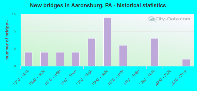
- New bridges - historical statistics
- 21910-1919
- 21920-1929
- 21930-1939
- 21940-1949
- 41950-1959
- 71960-1969
- 31970-1979
- 41990-1999
- 12010-2019
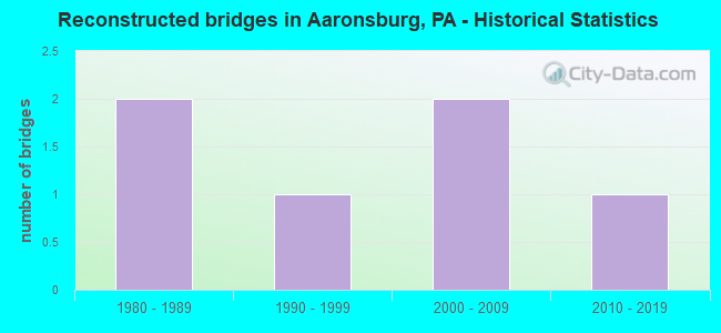
- Reconstructed bridges - Historical Statistics
- 21980-1989
- 11990-1999
- 22000-2009
- 12010-2019
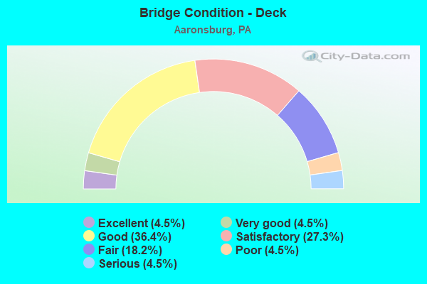
- Bridge Condition - Deck
- 4.5%Excellent
- 4.5%Very good
- 36.4%Good
- 27.3%Satisfactory
- 18.2%Fair
- 4.5%Poor
- 4.5%Serious
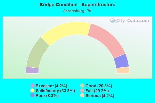
- Bridge Condition - Superstructure
- 4.2%Excellent
- 20.8%Good
- 33.3%Satisfactory
- 29.2%Fair
- 8.3%Poor
- 4.2%Serious
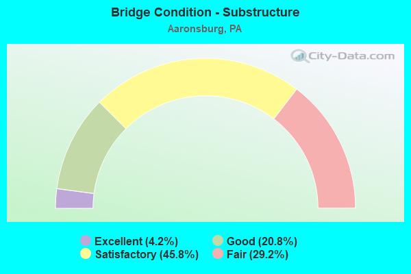
- Bridge Condition - Substructure
- 4.2%Excellent
- 20.8%Good
- 45.8%Satisfactory
- 29.2%Fair
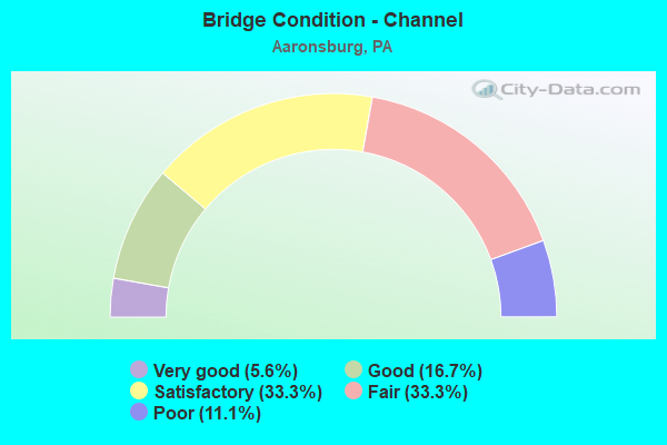
- Bridge Condition - Channel
- 5.6%Very good
- 16.7%Good
- 33.3%Satisfactory
- 33.3%Fair
- 11.1%Poor
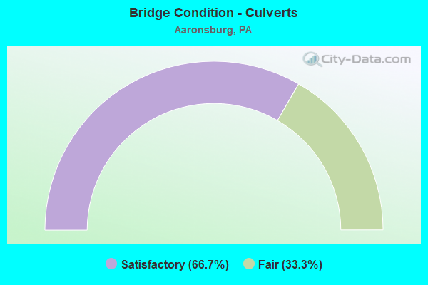
- Bridge Condition - Culverts
- 66.7%Satisfactory
- 33.3%Fair
Find on map >> Show street view
Structure Number: 367, Location: 1 MI N OF ARENDTSVILLE (Lat: 39.933919, Lng: -77.302583), Route carried "on" structure: State highway , Year Built: 1957, Status: Open, Structure Length: 1.28m (4.20ft), Average Daily Traffic: 1,146 (year 2022), Truck Traffic: 6%, Average Future Daily Traffic: 1,733 (year 2032), Design Load: HS 20, Features Intersected: CONEWAGO CREEK, Facility Carried by Structure: SR 4008
Minimum Vertical Clearance: 30+ m (98+ ft), Kilometerpoint: 0.000, Lanes on structure: 2, Owner: State Highway Agency, Approaching Roadway Width: 6.7m (22.0ft), Skew: 4 degrees, Material/Design: Steel, Design/Construction: Stringer/Multi-beam, Number Of Spans In Main Unit: 1, Length of Maximum Span: 10.4m (34.1ft), Curb or Sidewalk Widths: Left: 0.5m (1.6ft), Right: 0.5m (1.6ft), Curb-To-Curb Width: 9.1m (29.9ft), Out-to-Out Width: 10.8m (35.4ft)
Condition: Deck: Fair, Superstructure: Poor, Substructure: Satisfactory, Channel: Satisfactory, Operating Rating: 56.2 metric tons, Method Used To Determine Operating Rating: Load Factor (LF), Inventory Rating: 33.6 metric tons, Method Used To Determine Inventory Rating: Load Factor (LF), Structural Evaluation: Meets minimum limits, Deck Geometry: Somewhat better than minimum adequacy, Waterway Adequacy: Better than present minimum criteria, Approach Roadway Alignment: Better than present minimum criteria, Length Of Structure Improvement: 1.90m (6.23ft), Designated Inspection Frequency: Every 24 months, Inspection Date: April 2021, Bridge Improvement Cost: $5,000, Roadway Improvement Cost: $15,000, Total Project Cost: $68,000, Deck Structure Type: Concrete Cast-file-Place, Wearing Surface/Protective System: Wearing Surface: Bituminous
Find on map >> Show street view
Structure Number: 896, Location: GROVETON-I79 SB OVER SR51 (Lat: 40.503653, Lng: -80.137583), Route carried "on" structure: Interstate 79, Year Built: 1974, Status: Open, Structure Length: 6.58m (21.59ft), Average Daily Traffic: 17,627 (year 2020), Truck Traffic: 25%, Average Future Daily Traffic: 20,054 (year 2032), Design Load: HS 20, Features Intersected: SR 0051 AT GROVETON, Facility Carried by Structure: RAYMOND SHAFER HW
Minimum Vertical Clearance: 30+ m (98+ ft), Kilometerpoint: 23.813, Lanes on structure: 2, Lanes under structure: 10, Base Highway Network: Yes, Owner: State Highway Agency, Approaching Roadway Width: 12.2m (40.0ft), Skew: 16 degrees, Material/Design: Steel continuous, Design/Construction: Stringer/Multi-beam, Number Of Spans In Main Unit: 3, Length of Maximum Span: 31.7m (104.0ft), Curb or Sidewalk Widths: Left: 0.2m (0.7ft), Right: 0.2m (0.7ft), Curb-To-Curb Width: 12.2m (40.0ft), Out-to-Out Width: 13.4m (44.0ft)
Condition: Deck: Good, Superstructure: Satisfactory, Substructure: Good, Operating Rating: 54.4 metric tons, Method Used To Determine Operating Rating: Load Factor (LF), Inventory Rating: 32.7 metric tons, Method Used To Determine Inventory Rating: Load Factor (LF), Structural Evaluation: Equal to present minimum criteria, Deck Geometry: Better than present minimum criteria, Underclear: Equal to present minimum criteria, Approach Roadway Alignment: Equal to present desirable criteria, Length Of Structure Improvement: 6.60m (21.65ft), Designated Inspection Frequency: Every 24 months, Inspection Date: May 2020, Bridge Improvement Cost: $14,000, Roadway Improvement Cost: $41,000, Total Project Cost: $188,000, Deck Structure Type: Concrete Cast-file-Place, Wearing Surface/Protective System: Wearing Surface: Monolithic Concrete
Find on map >> Show street view
Structure Number: 2264, Location: OPA109 AP05 AIRPORT 10-1 (Lat: 40.498300, Lng: -80.258300), Route carried "on" structure: Ramp Other road , Year Built: 1992, Status: Open, Structure Length: 3.05m (10.01ft), Average Daily Traffic: 5,055 (year 2002), Truck Traffic: 6%, Average Future Daily Traffic: 5,055 (year 2019), Design Load: HS 25 or greater, Features Intersected: RAMP EP-E(NORTH), Facility Carried by Structure: RAMP EP-W RD
Minimum Vertical Clearance: 30+ m (98+ ft), Kilometerpoint: 0.000, Lanes on structure: 2, Lanes under structure: 2, Owner: Local Agency, Approaching Roadway Width: 8.5m (27.9ft), Skew: 4 degrees, Material/Design: Steel, Design/Construction: Stringer/Multi-beam, Number Of Spans In Main Unit: 1, Length of Maximum Span: 28.7m (94.2ft), Curb or Sidewalk Widths: Left: 0.2m (0.7ft), Right: 0.2m (0.7ft), Curb-To-Curb Width: 10.8m (35.4ft), Out-to-Out Width: 11.2m (36.7ft)
Condition: Deck: Good, Superstructure: Fair, Substructure: Good, Operating Rating: 75.3 metric tons, Method Used To Determine Operating Rating: Load Factor (LF), Inventory Rating: 45.4 metric tons, Method Used To Determine Inventory Rating: Load Factor (LF), Structural Evaluation: Somewhat better than minimum adequacy, Deck Geometry: Better than present minimum criteria, Underclear: Equal to present minimum criteria, Approach Roadway Alignment: Equal to present desirable criteria, Length Of Structure Improvement: 3.00m (9.84ft), Designated Inspection Frequency: Every 24 months, Inspection Date: June 2021, Deck Structure Type: Concrete Cast-file-Place, Wearing Surface/Protective System: Wearing Surface: Latex Concrete, Deck Protection: Epoxy Coated Reinforcing
Find on map >> Show street view
Structure Number: 3507, Location: 1.6 MI S OF GREENGARDEN R (Lat: 40.578533, Lng: -80.289339), Route carried "on" structure: Interstate 376, Year Built: 1969, Year Reconstructed: 2008, Status: Open, Structure Length: 3.23m (10.60ft), Average Daily Traffic: 16,688 (year 2021), Truck Traffic: 12%, Average Future Daily Traffic: 10,656 (year 2032), Design Load: HS 20, Features Intersected: BRYSON ROAD, Facility Carried by Structure: BEAVER VALLEY EXPY
Minimum Vertical Clearance: 30+ m (98+ ft), Kilometerpoint: 23.630, Lanes on structure: 2, Lanes under structure: 2, Base Highway Network: Yes, Owner: State Highway Agency, Approaching Roadway Width: 12.2m (40.0ft), Skew: 11 degrees, Material/Design: Steel, Design/Construction: Stringer/Multi-beam, Number Of Spans In Main Unit: 1, Length of Maximum Span: 31.1m (102.0ft), Curb or Sidewalk Widths: Left: 0.2m (0.7ft), Right: 0.2m (0.7ft), Curb-To-Curb Width: 12.2m (40.0ft), Out-to-Out Width: 13.4m (44.0ft)
Condition: Deck: Satisfactory, Superstructure: Satisfactory, Substructure: Satisfactory, Operating Rating: 63.5 metric tons, Method Used To Determine Operating Rating: Load Factor (LF), Inventory Rating: 38.1 metric tons, Method Used To Determine Inventory Rating: Load Factor (LF), Structural Evaluation: Equal to present minimum criteria, Deck Geometry: Better than present minimum criteria, Approach Roadway Alignment: Equal to present desirable criteria, Length Of Structure Improvement: 4.10m (13.45ft), Designated Inspection Frequency: Every 24 months, Inspection Date: April 2021, Bridge Improvement Cost: $48,000, Roadway Improvement Cost: $140,000, Total Project Cost: $642,000, Deck Structure Type: Concrete Cast-file-Place, Wearing Surface/Protective System: Wearing Surface: Latex Concrete
Find on map >> Show street view
Structure Number: 373, Location: RAMP G OVER APPL 294 (Lat: 40.592222, Lng: -80.240725), Route carried "on" structure: Ramp State highway , Year Built: 1965, Year Reconstructed: 1987, Status: Open, Structure Length: 1.71m (5.61ft), Average Daily Traffic: 2,192 (year 2022), Truck Traffic: 5%, Average Future Daily Traffic: 2,551 (year 2032), Design Load: HS 20, Features Intersected: SR 51 NB, Facility Carried by Structure: RAMP G RD
Minimum Vertical Clearance: 30+ m (98+ ft), Kilometerpoint: 0.000, Lanes on structure: 2, Lanes under structure: 2, Owner: State Highway Agency, Approaching Roadway Width: 8.5m (27.9ft), Material/Design: Steel, Design/Construction: Stringer/Multi-beam, Number Of Spans In Main Unit: 1, Length of Maximum Span: 16.5m (54.1ft), Curb or Sidewalk Widths: Left: 0.0m, Right: 1.5m (4.9ft), Curb-To-Curb Width: 8.5m (27.9ft), Out-to-Out Width: 11.3m (37.1ft)
Condition: Deck: Good, Superstructure: Good, Substructure: Satisfactory, Operating Rating: 55.3 metric tons, Method Used To Determine Operating Rating: Load Factor (LF), Inventory Rating: 33.6 metric tons, Method Used To Determine Inventory Rating: Load Factor (LF), Structural Evaluation: Equal to present minimum criteria, Deck Geometry: High priority of corrective action, Underclear: Meets minimum limits, Approach Roadway Alignment: Equal to present desirable criteria, Length Of Structure Improvement: 1.80m (5.91ft), Designated Inspection Frequency: Every 24 months, Inspection Date: April 2021, Bridge Improvement Cost: $3,000, Roadway Improvement Cost: $10,000, Total Project Cost: $44,000, Deck Structure Type: Concrete Cast-file-Place, Wearing Surface/Protective System: Wearing Surface: Monolithic Concrete
Find on map >> Show street view
Structure Number: 5406, Location: SUNDAYS MILL (Lat: 40.419522, Lng: -76.163972), Route carried "on" structure: City street , Year Built: 1993, Status: Open, Structure Length: 0.67m (2.20ft), Average Daily Traffic: 289 (year 2017), Truck Traffic: 6%, Average Future Daily Traffic: 325 (year 2033), Design Load: HS 25 or greater, Features Intersected: MILL RACE, Facility Carried by Structure: STATION ROAD
Minimum Vertical Clearance: 30+ m (98+ ft), Kilometerpoint: 0.000, Lanes on structure: 2, Owner: County Highway Agency, Approaching Roadway Width: 6.4m (21.0ft), Skew: 2 degrees, Material/Design: Steel, Design/Construction: Culvert, Number Of Spans In Main Unit: 1, Length of Maximum Span: 6.7m (22.0ft)
Condition: Channel: Good, Culverts: Satisfactory, Operating Rating: 87.1 metric tons, Method Used To Determine Operating Rating: Load Factor (LF), Inventory Rating: 51.7 metric tons, Method Used To Determine Inventory Rating: Load Factor (LF), Structural Evaluation: Equal to present minimum criteria, Waterway Adequacy: Better than present minimum criteria, Approach Roadway Alignment: Equal to present desirable criteria, Designated Inspection Frequency: Every 24 months, Inspection Date: May 2020
Find on map >> Show street view
Structure Number: 6413, Location: VILLAGE OF FRANKLINDALE (Lat: 41.701856, Lng: -76.554517), Route carried "on" structure: State highway , Year Built: 1965, Status: Open, Structure Length: 4.72m (15.49ft), Average Daily Traffic: 197 (year 2020), Truck Traffic: 8%, Average Future Daily Traffic: 209 (year 2032), Features Intersected: TOWANDA CREEK, Facility Carried by Structure: SR 3008
Minimum Vertical Clearance: 30+ m (98+ ft), Kilometerpoint: 25.846, Lanes on structure: 2, Owner: State Highway Agency, Approaching Roadway Width: 6.1m (20.0ft), Skew: 3 degrees, Material/Design: Steel continuous, Design/Construction: Stringer/Multi-beam, Number Of Spans In Main Unit: 2, Length of Maximum Span: 22.9m (75.1ft), Curb or Sidewalk Widths: Left: 0.5m (1.6ft), Right: 0.5m (1.6ft), Curb-To-Curb Width: 8.5m (27.9ft), Out-to-Out Width: 10.2m (33.5ft)
Condition: Deck: Good, Superstructure: Good, Substructure: Satisfactory, Channel: Good, Operating Rating: 57.2 metric tons, Method Used To Determine Operating Rating: Load Factor (LF), Inventory Rating: 34.5 metric tons, Method Used To Determine Inventory Rating: Load Factor (LF), Structural Evaluation: Equal to present minimum criteria, Deck Geometry: Equal to present minimum criteria, Waterway Adequacy: Superior to present desirable criteria, Approach Roadway Alignment: Better than present minimum criteria, Length Of Structure Improvement: 4.70m (15.42ft), Designated Inspection Frequency: Every 24 months, Inspection Date: October 2020, Bridge Improvement Cost: $6,000, Roadway Improvement Cost: $25,000, Total Project Cost: $83,000, Deck Structure Type: Concrete Cast-file-Place, Wearing Surface/Protective System: Wearing Surface: Bituminous, Membrane: Preformed Fabric
Find on map >> Show street view
Structure Number: 6415, Location: .25 MI.N.OF LEROY (Lat: 41.672950, Lng: -76.706553), Route carried "on" structure: State highway , Year Built: 1962, Status: Open, Structure Length: 2.71m (8.89ft), Average Daily Traffic: 425 (year 2022), Truck Traffic: 12%, Average Future Daily Traffic: 476 (year 2032), Design Load: H 20, Features Intersected: TOWANDA CREEK, Facility Carried by Structure: SR 3010
Minimum Vertical Clearance: 30+ m (98+ ft), Kilometerpoint: 0.000, Lanes on structure: 2, Owner: State Highway Agency, Approaching Roadway Width: 6.1m (20.0ft), Skew: 3 degrees, Material/Design: Steel, Design/Construction: Stringer/Multi-beam, Number Of Spans In Main Unit: 1, Length of Maximum Span: 25.3m (83.0ft), Curb or Sidewalk Widths: Left: 0.5m (1.6ft), Right: 0.5m (1.6ft), Curb-To-Curb Width: 9.1m (29.9ft), Out-to-Out Width: 10.8m (35.4ft)
Condition: Deck: Satisfactory, Superstructure: Good, Substructure: Fair, Channel: Satisfactory, Inventory Rating: 63.5 metric tons, Method Used To Determine Inventory Rating: Load Factor (LF), Structural Evaluation: Somewhat better than minimum adequacy, Deck Geometry: Equal to present minimum criteria, Waterway Adequacy: Superior to present desirable criteria, Approach Roadway Alignment: Equal to present desirable criteria, Length Of Structure Improvement: 2.70m (8.86ft), Designated Inspection Frequency: Every 24 months, Inspection Date: July 2020, Bridge Improvement Cost: $8,000, Roadway Improvement Cost: $50,000, Total Project Cost: $111,000, Deck Structure Type: Concrete Cast-file-Place, Wearing Surface/Protective System: Wearing Surface: Bituminous, Membrane: Preformed Fabric
Find on map >> Show street view
Structure Number: 662, Location: ST GM LND 36, OVERTON TWP (Lat: 41.636539, Lng: -76.519264), Route carried "on" structure: City street , Year Built: 1977, Status: Posted for load, Structure Length: 0.91m (2.99ft), Average Daily Traffic: 50 (year 2021), Average Future Daily Traffic: 77 (year 2043), Design Load: HS 20, Features Intersected: SOUTH BR. MILLSTONE CREE, Facility Carried by Structure: T-372 (TWP. BR#4)
Minimum Vertical Clearance: 30+ m (98+ ft), Kilometerpoint: 0.000, Lanes on structure: 2, Owner: Town or Township Highway Agency, Approaching Roadway Width: 4.6m (15.1ft), Skew: 4 degrees, Material/Design: Prestressed concrete, Design/Construction: Box Beam or Girders - Multiple, Number Of Spans In Main Unit: 1, Length of Maximum Span: 8.5m (27.9ft), Curb or Sidewalk Widths: Left: 0.2m (0.7ft), Right: 0.2m (0.7ft), Curb-To-Curb Width: 5.5m (18.0ft), Out-to-Out Width: 6.6m (21.7ft)
Condition: Deck: Serious, Superstructure: Serious, Substructure: Fair, Channel: Fair, Operating Rating: 49.9 metric tons, Method Used To Determine Operating Rating: Load Factor (LF), Inventory Rating: 26.3 metric tons, Method Used To Determine Inventory Rating: Load Factor (LF), Structural Evaluation: High priority of corrective action, Deck Geometry: Meets minimum limits, Waterway Adequacy: Better than present minimum criteria, Approach Roadway Alignment: Equal to present desirable criteria, Length Of Structure Improvement: 0.90m (2.95ft), Designated Inspection Frequency: Every 24 months, Other Special Inspection Frequency: Every 6 months, Inspection Date: July 2021, Other Special Inspection Date: July 2021, Bridge Improvement Cost: $5,000, Roadway Improvement Cost: $50,000, Total Project Cost: $71,000, Deck Structure Type: Other, Wearing Surface/Protective System: Wearing Surface: Bituminous
Find on map >> Show street view
Structure Number: 664, Location: 2 MI. NORTH OF ULSTER (Lat: 41.872147, Lng: -76.486489), Route carried "on" structure: City street , Year Built: 1977, Status: Open, Structure Length: 0.82m (2.69ft), Average Daily Traffic: 500 (year 2021), Truck Traffic: 25%, Average Future Daily Traffic: 770 (year 2043), Design Load: HS 20, Features Intersected: SNYDER CREEK, Facility Carried by Structure: T-687 (BR.#1)
Minimum Vertical Clearance: 30+ m (98+ ft), Kilometerpoint: 0.000, Lanes on structure: 2, Owner: Town or Township Highway Agency, Approaching Roadway Width: 5.8m (19.0ft), Skew: 4 degrees, Material/Design: Concrete, Design/Construction: Culvert, Number Of Spans In Main Unit: 1, Length of Maximum Span: 7.6m (24.9ft), Curb-To-Curb Width: 6.6m (21.7ft), Out-to-Out Width: 7.7m (25.3ft)
Condition: Channel: Poor, Culverts: Fair, Operating Rating: 54.4 metric tons, Method Used To Determine Operating Rating: Field evaluation and documented engineering judgment, Inventory Rating: 32.7 metric tons, Method Used To Determine Inventory Rating: Field evaluation and documented engineering judgment, Structural Evaluation: Somewhat better than minimum adequacy, Deck Geometry: High priority of corrective action, Waterway Adequacy: Better than present minimum criteria, Approach Roadway Alignment: Equal to present desirable criteria, Length Of Structure Improvement: 1.40m (4.59ft), Designated Inspection Frequency: Every 24 months, Other Special Inspection Frequency: Every 6 months, Inspection Date: June 2021, Other Special Inspection Date: December 2021, Wearing Surface/Protective System: Wearing Surface: Gravel
Find on map >> Show street view
Structure Number: 998, Location: E.OF DOWNINGTOWN 21A13 (Lat: 40.019114, Lng: -75.675597), Route carried "on" structure: US 30, Year Built: 1961, Year Reconstructed: 1995, Status: Open, Structure Length: 8.75m (28.71ft), Average Daily Traffic: 38,891 (year 2022), Truck Traffic: 6%, Average Future Daily Traffic: 34,326 (year 2032), Design Load: HS 20, Features Intersected: ROUTE US 30 BUSINESS, Facility Carried by Structure: EXTON BYPASS(EB)
Minimum Vertical Clearance: 30+ m (98+ ft), Kilometerpoint: 26.097, Lanes on structure: 2, Lanes under structure: 4, Base Highway Network: Yes, Owner: State Highway Agency, Approaching Roadway Width: 11.0m (36.1ft), Skew: 15 degrees, Material/Design: Steel continuous, Design/Construction: Stringer/Multi-beam, Number Of Spans In Main Unit: 3, Length of Maximum Span: 42.4m (139.1ft), Curb or Sidewalk Widths: Left: 0.2m (0.7ft), Right: 0.2m (0.7ft), Curb-To-Curb Width: 10.4m (34.1ft), Out-to-Out Width: 11.4m (37.4ft)
Condition: Deck: Good, Superstructure: Satisfactory, Substructure: Satisfactory, Operating Rating: 81.6 metric tons, Method Used To Determine Operating Rating: Load Factor (LF), Inventory Rating: 49.0 metric tons, Method Used To Determine Inventory Rating: Load Factor (LF), Structural Evaluation: Equal to present minimum criteria, Deck Geometry: Meets minimum limits, Underclear: High priority of corrective action, Approach Roadway Alignment: Equal to present desirable criteria, Length Of Structure Improvement: 9.40m (30.84ft), Designated Inspection Frequency: Every 24 months, Inspection Date: June 2020, Deck Structure Type: Concrete Cast-file-Place, Wearing Surface/Protective System: Wearing Surface: Monolithic Concrete, Deck Protection: Epoxy Coated Reinforcing
Find on map >> Show street view
Structure Number: 10316, Location: BERWYN 24E8 (Lat: 40.046736, Lng: -75.445308), Route carried "on" structure: State highway , Year Built: 1957, Year Reconstructed: 2018, Status: Open, Structure Length: 2.04m (6.69ft), Average Daily Traffic: 5,514 (year 2022), Truck Traffic: 7%, Average Future Daily Traffic: 6,835 (year 2032), Design Load: HS 20, Features Intersected: AMTRAK (PHILA TO PITT), Facility Carried by Structure: OLD LANCASTER ROAD
Minimum Vertical Clearance: 30.18m (99.02ft), Kilometerpoint: 0.000, Lanes on structure: 2, Owner: Railroad, Approaching Roadway Width: 7.6m (24.9ft), Material/Design: Steel, Design/Construction: Girder and Floorbeam System, Number Of Spans In Main Unit: 1, Length of Maximum Span: 20.1m (65.9ft), Curb or Sidewalk Widths: Left: 1.6m (5.2ft), Right: 0.0m, Curb-To-Curb Width: 6.3m (20.7ft), Out-to-Out Width: 8.1m (26.6ft)
Condition: Deck: Very good, Superstructure: Satisfactory, Substructure: Satisfactory, Operating Rating: 81.6 metric tons, Method Used To Determine Operating Rating: Load Factor (LF), Inventory Rating: 49.0 metric tons, Method Used To Determine Inventory Rating: Load Factor (LF), Structural Evaluation: Equal to present minimum criteria, Deck Geometry: High priority of replacement, Underclear: High priority of corrective action, Approach Roadway Alignment: Meets minimum limits, Length Of Structure Improvement: 2.60m (8.53ft), Designated Inspection Frequency: Every 24 months, Critical Feature Inspection Frequency: Every 24 months, Inspection Date: June 2021, Critical Feature Inspection Date: June 2021, Bridge Improvement Cost: $24,000, Roadway Improvement Cost: $72,000, Total Project Cost: $329,000, Deck Structure Type: Steel plate, Wearing Surface/Protective System: Wearing Surface: Bituminous
Find on map >> Show street view
Structure Number: 10413, Location: THORBURY TWP;CHEYEY 41H12 (Lat: 39.929325, Lng: -75.532978), Route carried "on" structure: State highway , Year Built: 1990, Status: Open, Structure Length: 1.49m (4.89ft), Average Daily Traffic: 2,430 (year 2022), Truck Traffic: 9%, Average Future Daily Traffic: 2,758 (year 2032), Design Load: HS 25 or greater, Features Intersected: CHESTER CREEK, Facility Carried by Structure: DILWORTHTOWN ROAD
Minimum Vertical Clearance: 30+ m (98+ ft), Kilometerpoint: 0.000, Lanes on structure: 2, Owner: State Highway Agency, Approaching Roadway Width: 8.8m (28.9ft), Material/Design: Prestressed concrete, Design/Construction: Box Beam or Girders - Multiple, Number Of Spans In Main Unit: 1, Length of Maximum Span: 14.9m (48.9ft), Curb or Sidewalk Widths: Left: 0.2m (0.7ft), Right: 0.2m (0.7ft), Curb-To-Curb Width: 8.7m (28.5ft), Out-to-Out Width: 9.9m (32.5ft)
Condition: Deck: Good, Superstructure: Good, Substructure: Good, Channel: Good, Inventory Rating: 50.8 metric tons, Method Used To Determine Inventory Rating: Load Factor (LF), Structural Evaluation: Better than present minimum criteria, Deck Geometry: Meets minimum limits, Waterway Adequacy: Somewhat better than minimum adequacy, Approach Roadway Alignment: Somewhat better than minimum adequacy, Length Of Structure Improvement: 2.20m (7.22ft), Designated Inspection Frequency: Every 24 months, Inspection Date: August 2020, Deck Structure Type: Concrete Cast-file-Place, Wearing Surface/Protective System: Wearing Surface: Monolithic Concrete, Deck Protection: Epoxy Coated Reinforcing
Find on map >> Show street view
Structure Number: 13982, Location: UPPER MIFFLIN TWP (Lat: 40.188481, Lng: -77.458828), Route carried "on" structure: Interstate 76, Year Built: 1938, Status: Open, Structure Length: 0.67m (2.20ft), Average Daily Traffic: 21,102 (year 2001), Truck Traffic: 38%, Average Future Daily Traffic: 23,285 (year 2030), Design Load: HS 20, Features Intersected: WHISKEY RUN
Minimum Vertical Clearance: 30+ m (98+ ft), Kilometerpoint: 0.000, Lanes on structure: 6, Base Highway Network: Yes, Toll: On toll road, Owner: State Toll Authority, Approaching Roadway Width: 23.8m (78.1ft), Skew: 32 degrees, Material/Design: Concrete, Design/Construction: Culvert, Number Of Spans In Main Unit: 1, Length of Maximum Span: 6.7m (22.0ft)
Condition: Channel: Satisfactory, Culverts: Satisfactory, Operating Rating: 89.8 metric tons, Method Used To Determine Operating Rating: Load Factor (LF), Inventory Rating: 32.7 metric tons, Method Used To Determine Inventory Rating: Load Factor (LF), Structural Evaluation: Equal to present minimum criteria, Waterway Adequacy: Superior to present desirable criteria, Approach Roadway Alignment: Equal to present desirable criteria, Length Of Structure Improvement: 1.60m (5.25ft), Designated Inspection Frequency: Every 48 months, Inspection Date: January 2019
Find on map >> Show street view
Structure Number: 14191, Location: 2.5 MI N.E. KILLINGER (Lat: 40.577844, Lng: -76.887647), Route carried "on" structure: State highway 25, Year Built: 1930, Status: Open, Structure Length: 0.73m (2.40ft), Average Daily Traffic: 2,053 (year 2022), Truck Traffic: 7%, Average Future Daily Traffic: 3,799 (year 2032), Design Load: H 15, Features Intersected: LITTLE WICONISCO CREEK
Minimum Vertical Clearance: 30+ m (98+ ft), Kilometerpoint: 7.321, Lanes on structure: 2, Owner: State Highway Agency, Approaching Roadway Width: 8.8m (28.9ft), Material/Design: Concrete, Design/Construction: Arch - Deck, Number Of Spans In Main Unit: 1, Length of Maximum Span: 7.3m (24.0ft), Curb-To-Curb Width: 9.2m (30.2ft), Out-to-Out Width: 10.0m (32.8ft)
Condition: Superstructure: Fair, Substructure: Fair, Channel: Fair, Operating Rating: 63.5 metric tons, Method Used To Determine Operating Rating: Allowable Stress (AS), Inventory Rating: 42.6 metric tons, Method Used To Determine Inventory Rating: Allowable Stress (AS), Structural Evaluation: Somewhat better than minimum adequacy, Deck Geometry: Meets minimum limits, Waterway Adequacy: Superior to present desirable criteria, Approach Roadway Alignment: Equal to present desirable criteria, Length Of Structure Improvement: 1.40m (4.59ft), Designated Inspection Frequency: Every 24 months, Inspection Date: August 2020, Bridge Improvement Cost: $7,000, Roadway Improvement Cost: $20,000, Total Project Cost: $91,000
Find on map >> Show street view
Structure Number: 14845, Location: CHURCH LANE 36B01 (Lat: 39.939600, Lng: -75.256453), Route carried "on" structure: US 13, Year Built: 1993, Status: Open, Structure Length: 5.55m (18.21ft), Average Daily Traffic: 15,247 (year 2021), Truck Traffic: 3%, Average Future Daily Traffic: 16,183 (year 2032), Design Load: HS 25 or greater, Features Intersected: SEPTA,FAIRVIEW,RAILRD AV, Facility Carried by Structure: CHURCH LANE
Minimum Vertical Clearance: 30+ m (98+ ft), Kilometerpoint: 23.316, Lanes on structure: 2, Lanes under structure: 4, Base Highway Network: Yes, Owner: State Highway Agency, Approaching Roadway Width: 8.8m (28.9ft), Material/Design: Prestressed concrete, Design/Construction: Box Beam or Girders - Multiple, Number Of Spans In Main Unit: 1, Number Of Approach Spans: 2, Length of Maximum Span: 23.8m (78.1ft), Curb or Sidewalk Widths: Left: 1.7m (5.6ft), Right: 1.7m (5.6ft), Curb-To-Curb Width: 9.1m (29.9ft), Out-to-Out Width: 14.2m (46.6ft)
Condition: Deck: Satisfactory, Superstructure: Good, Substructure: Good, Operating Rating: 72.6 metric tons, Method Used To Determine Operating Rating: Load Factor (LF), Inventory Rating: 43.5 metric tons, Method Used To Determine Inventory Rating: Load Factor (LF), Structural Evaluation: Better than present minimum criteria, Deck Geometry: High priority of corrective action, Underclear: Meets minimum limits, Approach Roadway Alignment: Equal to present minimum criteria, Length Of Structure Improvement: 11.60m (38.06ft), Designated Inspection Frequency: Every 24 months, Inspection Date: November 2019, Deck Structure Type: Concrete Cast-file-Place, Wearing Surface/Protective System: Wearing Surface: Monolithic Concrete, Deck Protection: Epoxy Coated Reinforcing
Find on map >> Show street view
Structure Number: 16352, Location: WASHINGTON TOWNSHIP (Lat: 41.899728, Lng: -80.055072), Route carried "on" structure: State highway , Year Built: 1956, Status: Open, Structure Length: 1.31m (4.30ft), Average Daily Traffic: 511 (year 2021), Truck Traffic: 6%, Average Future Daily Traffic: 555 (year 2032), Design Load: HS 20, Features Intersected: OVER LT CONNEAUTTEE CK, Facility Carried by Structure: SR 3025,CONNEAUTEE
Minimum Vertical Clearance: 30+ m (98+ ft), Kilometerpoint: 5.795, Lanes on structure: 2, Owner: State Highway Agency, Approaching Roadway Width: 6.4m (21.0ft), Skew: 6 degrees, Material/Design: Steel, Design/Construction: Stringer/Multi-beam, Number Of Spans In Main Unit: 1, Length of Maximum Span: 12.5m (41.0ft), Curb-To-Curb Width: 7.4m (24.3ft), Out-to-Out Width: 7.9m (25.9ft)
Condition: Deck: Good, Superstructure: Fair, Substructure: Fair, Channel: Fair, Operating Rating: 59.9 metric tons, Method Used To Determine Operating Rating: Load Factor (LF), Inventory Rating: 36.3 metric tons, Method Used To Determine Inventory Rating: Load Factor (LF), Structural Evaluation: Somewhat better than minimum adequacy, Deck Geometry: Meets minimum limits, Waterway Adequacy: Equal to present minimum criteria, Approach Roadway Alignment: Better than present minimum criteria, Length Of Structure Improvement: 2.00m (6.56ft), Designated Inspection Frequency: Every 24 months, Inspection Date: August 2021, Deck Structure Type: Closed Grating, Wearing Surface/Protective System: Wearing Surface: Bituminous, Membrane: Preformed Fabric
Find on map >> Show street view
Structure Number: 17879, Location: 1.5 MI.W.OF MCCONNELSBURG (Lat: 39.938056, Lng: -78.016731), Route carried "on" structure: State highway , Year Built: 1966, Year Reconstructed: 2008, Status: Open, Structure Length: 4.91m (16.11ft), Average Daily Traffic: 2,103 (year 2022), Truck Traffic: 5%, Average Future Daily Traffic: 3,019 (year 2032), Design Load: HS 20, Features Intersected: US 30, Facility Carried by Structure: SR 1004
Minimum Vertical Clearance: 30+ m (98+ ft), Kilometerpoint: 1.065, Lanes on structure: 2, Lanes under structure: 3, Base Highway Network: Yes, Owner: State Highway Agency, Approaching Roadway Width: 9.1m (29.9ft), Skew: 2 degrees, Material/Design: Prestressed concrete, Design/Construction: Box Beam or Girders - Single/Spread, Number Of Spans In Main Unit: 3, Length of Maximum Span: 22.6m (74.1ft), Curb-To-Curb Width: 9.8m (32.2ft), Out-to-Out Width: 11.4m (37.4ft)
Condition: Deck: Good, Superstructure: Satisfactory, Substructure: Satisfactory, Operating Rating: 78.9 metric tons, Method Used To Determine Operating Rating: Load Factor (LF), Inventory Rating: 33.6 metric tons, Method Used To Determine Inventory Rating: Load Factor (LF), Structural Evaluation: Equal to present minimum criteria, Deck Geometry: Meets minimum limits, Underclear: Superior to present desirable criteria, Approach Roadway Alignment: Better than present minimum criteria, Length Of Structure Improvement: 6.10m (20.01ft), Designated Inspection Frequency: Every 24 months, Inspection Date: July 2020, Bridge Improvement Cost: $148,000, Roadway Improvement Cost: $436,000, Total Project Cost: $1,997,000, Deck Structure Type: Concrete Cast-file-Place, Wearing Surface/Protective System: Wearing Surface: Latex Concrete
Find on map >> Show street view
Structure Number: 19871, Location: 1.3 MILES WEST OF SR 119 (Lat: 40.922139, Lng: -79.006056), Route carried "on" structure: City street , Year Built: 1969, Status: Open, Structure Length: 4.15m (13.62ft), Average Daily Traffic: 311 (year 2021), Truck Traffic: 9%, Average Future Daily Traffic: 435 (year 2041), Design Load: HS 20, Features Intersected: MAHONING CREEK, Facility Carried by Structure: T-375 GRESOCK RD
Minimum Vertical Clearance: 30+ m (98+ ft), Kilometerpoint: 0.000, Lanes on structure: 2, Owner: County Highway Agency, Approaching Roadway Width: 6.1m (20.0ft), Material/Design: Prestressed concrete, Design/Construction: Box Beam or Girders - Multiple, Number Of Spans In Main Unit: 2, Length of Maximum Span: 20.1m (65.9ft), Curb or Sidewalk Widths: Left: 0.2m (0.7ft), Right: 0.2m (0.7ft), Curb-To-Curb Width: 6.6m (21.7ft), Out-to-Out Width: 7.8m (25.6ft)
Condition: Deck: Poor, Superstructure: Poor, Substructure: Good, Channel: Satisfactory, Inventory Rating: 53.5 metric tons, Method Used To Determine Inventory Rating: Load Factor (LF), Structural Evaluation: Meets minimum limits, Deck Geometry: Meets minimum limits, Waterway Adequacy: Better than present minimum criteria, Approach Roadway Alignment: Equal to present desirable criteria, Length Of Structure Improvement: 5.00m (16.40ft), Designated Inspection Frequency: Every 24 months, Inspection Date: July 2021, Deck Structure Type: Other, Wearing Surface/Protective System: Wearing Surface: Bituminous, Membrane: Preformed Fabric
Find on map >> Show street view
Structure Number: 1999, Location: OAKLAND MILLS (Lat: 40.614856, Lng: -77.315367), Route carried "on" structure: State highway 35, Year Built: 1941, Status: Open, Structure Length: 1.68m (5.51ft), Average Daily Traffic: 4,713 (year 2021), Truck Traffic: 12%, Average Future Daily Traffic: 6,107 (year 2041), Design Load: H 20, Features Intersected: LOST CREEK
Minimum Vertical Clearance: 30+ m (98+ ft), Kilometerpoint: 49.053, Lanes on structure: 2, Base Highway Network: Yes, Owner: State Highway Agency, Approaching Roadway Width: 8.5m (27.9ft), Skew: 1 degrees, Material/Design: Concrete, Design/Construction: Tee Beam, Number Of Spans In Main Unit: 2, Length of Maximum Span: 7.9m (25.9ft), Curb or Sidewalk Widths: Left: 0.2m (0.7ft), Right: 1.5m (4.9ft), Curb-To-Curb Width: 7.3m (24.0ft), Out-to-Out Width: 9.9m (32.5ft)
Condition: Deck: Fair, Superstructure: Fair, Substructure: Fair, Channel: Fair, Operating Rating: 52.6 metric tons, Method Used To Determine Operating Rating: Allowable Stress (AS), Inventory Rating: 30.8 metric tons, Method Used To Determine Inventory Rating: Allowable Stress (AS), Structural Evaluation: Somewhat better than minimum adequacy, Deck Geometry: High priority of replacement, Waterway Adequacy: Equal to present minimum criteria, Approach Roadway Alignment: Equal to present desirable criteria, Length Of Structure Improvement: 1.70m (5.58ft), Designated Inspection Frequency: Every 24 months, Inspection Date: September 2021, Bridge Improvement Cost: $39,000, Roadway Improvement Cost: $250,000, Total Project Cost: $522,000, Deck Structure Type: Concrete Cast-file-Place, Wearing Surface/Protective System: Wearing Surface: Bituminous
Find on map >> Show street view
Structure Number: 27088, Location: NEAR KELLERSVILLE (Lat: 40.942125, Lng: -75.302033), Route carried "on" structure: City street , Year Built: 1912, Status: Posted for load, Structure Length: 1.62m (5.31ft), Average Daily Traffic: 189 (year 2004), Truck Traffic: 1%, Average Future Daily Traffic: 450 (year 2030), Features Intersected: McMICHAEL CREEK, Facility Carried by Structure: BUSH LN T-233
Minimum Vertical Clearance: 30+ m (98+ ft), Kilometerpoint: 0.000, Lanes on structure: 2, Owner: County Highway Agency, Approaching Roadway Width: 4.9m (16.1ft), Material/Design: Masonry, Design/Construction: Arch - Deck, Number Of Spans In Main Unit: 2, Length of Maximum Span: 7.0m (23.0ft), Curb-To-Curb Width: 4.9m (16.1ft), Out-to-Out Width: 4.9m (16.1ft)
Condition: Superstructure: Fair, Substructure: Satisfactory, Channel: Fair, Operating Rating: 49.0 metric tons, Method Used To Determine Operating Rating: Field evaluation and documented engineering judgment, Inventory Rating: 32.7 metric tons, Method Used To Determine Inventory Rating: Field evaluation and documented engineering judgment, Structural Evaluation: Somewhat better than minimum adequacy, Deck Geometry: High priority of replacement, Waterway Adequacy: Better than present minimum criteria, Approach Roadway Alignment: Equal to present desirable criteria, Length Of Structure Improvement: 2.30m (7.55ft), Designated Inspection Frequency: Every 24 months, Other Special Inspection Frequency: Every 12 months, Inspection Date: April 2020, Other Special Inspection Date: April 2021, Bridge Improvement Cost: $6,000, Roadway Improvement Cost: $18,000, Total Project Cost: $82,000
Find on map >> Show street view
Structure Number: 27089, Location: SW OF HAMILTON SQUARE (Lat: 40.919311, Lng: -75.305172), Route carried "on" structure: City street , Year Built: 1922, Status: Closed, Structure Length: 0.79m (2.59ft), Average Daily Traffic: 278 (year 2003), Truck Traffic: 1%, Average Future Daily Traffic: 250 (year 2000), Features Intersected: LAKE CREEK, Facility Carried by Structure: METZGAR RD (T-237)
Minimum Vertical Clearance: 30+ m (98+ ft), Kilometerpoint: 0.000, Lanes on structure: 2, Owner: County Highway Agency, Approaching Roadway Width: 4.9m (16.1ft), Skew: 2 degrees, Material/Design: Steel, Design/Construction: Stringer/Multi-beam, Number Of Spans In Main Unit: 1, Length of Maximum Span: 7.3m (24.0ft), Curb-To-Curb Width: 5.0m (16.4ft), Out-to-Out Width: 5.4m (17.7ft)
Condition: Deck: Satisfactory, Superstructure: Fair, Substructure: Satisfactory, Channel: Satisfactory, Operating Rating: 20.0 metric tons, Method Used To Determine Operating Rating: Field evaluation and documented engineering judgment, Inventory Rating: 14.5 metric tons, Method Used To Determine Inventory Rating: Field evaluation and documented engineering judgment, Structural Evaluation: Meets minimum limits, Waterway Adequacy: Equal to present minimum criteria, Approach Roadway Alignment: Equal to present minimum criteria, Bridge Posting: Required (Relationship of Operating Rating to Maximum Legal Load: > 39.9% below), Length Of Structure Improvement: 0.80m (2.62ft), Designated Inspection Frequency: Every 24 months, Other Special Inspection Frequency: Every 12 months, Inspection Date: April 2020, Other Special Inspection Date: April 2021, Bridge Improvement Cost: $29,000, Roadway Improvement Cost: $87,000, Total Project Cost: $395,000, Deck Structure Type: Concrete Cast-file-Place, Wearing Surface/Protective System: Wearing Surface: Bituminous
Find on map >> Show street view
Structure Number: 28744, Location: BETHMAN RD.OVER U.S.22 (Lat: 40.683014, Lng: -75.278542), Route carried "on" structure: State highway , Year Built: 1954, Status: Open, Structure Length: 2.59m (8.50ft), Average Daily Traffic: 2,835 (year 2022), Truck Traffic: 4%, Average Future Daily Traffic: 3,302 (year 2036), Design Load: HS 20, Features Intersected: US 22 (LR 772), Facility Carried by Structure: SR 2028 (LR 48017)
Minimum Vertical Clearance: 30+ m (98+ ft), Kilometerpoint: 7.081, Lanes on structure: 2, Lanes under structure: 8, Owner: State Highway Agency, Approaching Roadway Width: 9.1m (29.9ft), Material/Design: Concrete, Design/Construction: Frame, Number Of Spans In Main Unit: 1, Length of Maximum Span: 25.9m (85.0ft), Curb or Sidewalk Widths: Left: 0.3m (1.0ft), Right: 0.3m (1.0ft), Curb-To-Curb Width: 9.8m (32.2ft), Out-to-Out Width: 10.8m (35.4ft)
Condition: Deck: Fair, Superstructure: Satisfactory, Substructure: Satisfactory, Operating Rating: 81.6 metric tons, Method Used To Determine Operating Rating: Load Factor (LF), Inventory Rating: 49.0 metric tons, Method Used To Determine Inventory Rating: Load Factor (LF), Structural Evaluation: Equal to present minimum criteria, Deck Geometry: Meets minimum limits, Underclear: High priority of corrective action, Approach Roadway Alignment: Equal to present desirable criteria, Length Of Structure Improvement: 3.70m (12.14ft), Designated Inspection Frequency: Every 24 months, Inspection Date: October 2021, Bridge Improvement Cost: $16,000, Roadway Improvement Cost: $47,000, Total Project Cost: $216,000, Deck Structure Type: Concrete Cast-file-Place, Wearing Surface/Protective System: Wearing Surface: Monolithic Concrete
Find on map >> Show street view
Structure Number: 29296, Location: 1.5 MI SOUTH OF SUNBURY (Lat: 40.830953, Lng: -76.798669), Route carried "on" structure: State highway , Year Built: 1911, Year Reconstructed: 1992, Status: Open, Structure Length: 0.73m (2.40ft), Average Daily Traffic: 2,983 (year 2022), Truck Traffic: 6%, Average Future Daily Traffic: 5,466 (year 2032), Features Intersected: INDIAN SPRINGS, Facility Carried by Structure: SR 4018
Minimum Vertical Clearance: 30+ m (98+ ft), Kilometerpoint: 0.763, Lanes on structure: 2, Owner: State Highway Agency, Approaching Roadway Width: 7.6m (24.9ft), Material/Design: Concrete, Design/Construction: Slab, Number Of Spans In Main Unit: 1, Length of Maximum Span: 7.0m (23.0ft), Curb-To-Curb Width: 8.3m (27.2ft), Out-to-Out Width: 8.7m (28.5ft)
Condition: Deck: Satisfactory, Superstructure: Satisfactory, Substructure: Satisfactory, Channel: Poor, Operating Rating: 89.8 metric tons, Method Used To Determine Operating Rating: Load Factor (LF), Inventory Rating: 63.5 metric tons, Method Used To Determine Inventory Rating: Load Factor (LF), Structural Evaluation: Equal to present minimum criteria, Deck Geometry: High priority of corrective action, Waterway Adequacy: Somewhat better than minimum adequacy, Approach Roadway Alignment: Equal to present desirable criteria, Length Of Structure Improvement: 0.70m (2.30ft), Designated Inspection Frequency: Every 24 months, Inspection Date: November 2021, Bridge Improvement Cost: $7,000, Roadway Improvement Cost: $50,000, Total Project Cost: $92,000, Wearing Surface/Protective System: Wearing Surface: Bituminous, Membrane: Preformed Fabric
Find on map >> Show street view
Structure Number: 32607, Location: SPRNGVLE TP 1.5M W SR3013 (Lat: 41.663767, Lng: -75.966706), Route carried "on" structure: State highway , Year Built: 1949, Status: Open, Structure Length: 1.46m (4.79ft), Average Daily Traffic: 364 (year 2022), Truck Traffic: 8%, Average Future Daily Traffic: 132 (year 2032), Design Load: HS 20, Features Intersected: WHITE CREEK, Facility Carried by Structure: SR 3012 TWP RD 404
Minimum Vertical Clearance: 30+ m (98+ ft), Kilometerpoint: 0.000, Lanes on structure: 1, Owner: State Highway Agency, Approaching Roadway Width: 4.0m (13.1ft), Skew: 2 degrees, Material/Design: Concrete, Design/Construction: Slab, Number Of Spans In Main Unit: 2, Length of Maximum Span: 6.7m (22.0ft), Curb or Sidewalk Widths: Left: 0.2m (0.7ft), Right: 0.2m (0.7ft), Curb-To-Curb Width: 4.6m (15.1ft), Out-to-Out Width: 5.5m (18.0ft)
Condition: Deck: Fair, Superstructure: Fair, Substructure: Fair, Channel: Satisfactory, Operating Rating: 75.3 metric tons, Method Used To Determine Operating Rating: Field evaluation and documented engineering judgment, Inventory Rating: 45.4 metric tons, Method Used To Determine Inventory Rating: Field evaluation and documented engineering judgment, Structural Evaluation: Somewhat better than minimum adequacy, Deck Geometry: High priority of replacement, Waterway Adequacy: Better than present minimum criteria, Approach Roadway Alignment: Equal to present desirable criteria, Length Of Structure Improvement: 1.50m (4.92ft), Designated Inspection Frequency: Every 24 months, Inspection Date: April 2020, Bridge Improvement Cost: $24,000, Roadway Improvement Cost: $100,000, Total Project Cost: $323,000, Wearing Surface/Protective System: Wearing Surface: Monolithic Concrete
Find on map >> Show street view
Structure Number: 34971, Location: BETWEEN SR 88 & MON RIVER (Lat: 40.010978, Lng: -79.993933), Route carried "on" structure: City street , Year Built: 1920, Status: Open, Structure Length: 1.31m (4.30ft), Average Daily Traffic: 5 (year 2006), Average Future Daily Traffic: 100 (year 2026), Design Load: H 15, Features Intersected: FISHPOT RUN, Facility Carried by Structure: FLUSHING ROAD
Minimum Vertical Clearance: 30+ m (98+ ft), Kilometerpoint: 0.000, Lanes on structure: 1, Owner: Town or Township Highway Agency, Approaching Roadway Width: 4.3m (14.1ft), Material/Design: Steel, Design/Construction: Stringer/Multi-beam, Number Of Spans In Main Unit: 1, Length of Maximum Span: 12.5m (41.0ft), Curb-To-Curb Width: 4.6m (15.1ft), Out-to-Out Width: 5.2m (17.1ft)
Condition: Deck: Satisfactory, Superstructure: Satisfactory, Substructure: Fair, Channel: Fair, Operating Rating: 99.8 metric tons, Method Used To Determine Operating Rating: Load Factor (LF), Inventory Rating: 59.9 metric tons, Method Used To Determine Inventory Rating: Load Factor (LF), Structural Evaluation: Somewhat better than minimum adequacy, Deck Geometry: Better than present minimum criteria, Waterway Adequacy: Better than present minimum criteria, Approach Roadway Alignment: Equal to present desirable criteria, Length Of Structure Improvement: 1.40m (4.59ft), Designated Inspection Frequency: Every 24 months, Inspection Date: October 2020, Bridge Improvement Cost: $26,000, Roadway Improvement Cost: $100,000, Total Project Cost: $351,000, Deck Structure Type: Open Grating
Find on map >> Show street view
Structure Number: 54129, Location: 2 MI NE COBURN (Lat: 40.881992, Lng: -77.419431), Route carried "on" structure: State highway , Year Built: 2017, Status: Open, Structure Length: 2.01m (6.59ft), Average Daily Traffic: 123 (year 2020), Truck Traffic: 2%, Average Future Daily Traffic: 174 (year 2037), Design Load: HL 93, Features Intersected: Pine Creek, Facility Carried by Structure: Bower Hollow Road
Minimum Vertical Clearance: 30+ m (98+ ft), Kilometerpoint: 0.000, Lanes on structure: 2, Owner: State Highway Agency, Maintenance Responsibility: Private, Approaching Roadway Width: 4.9m (16.1ft), Material/Design: Prestressed concrete, Design/Construction: Box Beam or Girders - Single/Spread, Number Of Spans In Main Unit: 1, Length of Maximum Span: 19.2m (63.0ft), Curb-To-Curb Width: 8.6m (28.2ft), Out-to-Out Width: 9.2m (30.2ft)
Condition: Deck: Excellent, Superstructure: Excellent, Substructure: Excellent, Channel: Very good, Operating Rating: 54.8 metric tons, Method Used To Determine Operating Rating: Assigned ratings based on Load and Resistance Factor Design (LRFD) reported by rating factor (RF) using HL93 loadings, Inventory Rating: 42.4 metric tons, Method Used To Determine Inventory Rating: Assigned ratings based on Load and Resistance Factor Design (LRFD) reported by rating factor (RF) using HL93 loadings, Structural Evaluation: Superior to present desirable criteria, Deck Geometry: Equal to present minimum criteria, Waterway Adequacy: Equal to present desirable criteria, Approach Roadway Alignment: Somewhat better than minimum adequacy, Designated Inspection Frequency: Every 24 months, Inspection Date: August 2021, Deck Structure Type: Concrete Cast-file-Place, Wearing Surface/Protective System: Wearing Surface: Integral Concrete, Deck Protection: Epoxy Coated Reinforcing