Bridge Statistics for Abbeville, Alabama (AL)
Condition, Traffic, Stress, Structural Evaluation, Project Costs
- National Bridge Inventory (NBI) Statistics
- 24Number of bridges
- 285ft / 87.2mTotal length
- $28,006,000Total costs
- 29,621Total average daily traffic
- 3,098Total average daily truck traffic
- 39,463Total future (year 2033) average daily traffic
- National Bridge Inventory (NBI) Registered Bridges for Abbeville
- No street view available for this location
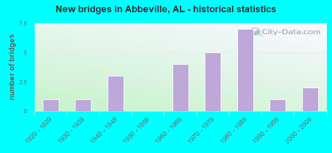
- New bridges - historical statistics
- 11920-1929
- 11930-1939
- 31940-1949
- 41960-1969
- 51970-1979
- 71980-1989
- 11990-1999
- 22000-2009


- Bridge Condition - Deck
- 77.8%Good
- 22.2%Fair

- Bridge Condition - Superstructure
- 88.9%Good
- 11.1%Satisfactory

- Bridge Condition - Substructure
- 55.6%Good
- 44.4%Satisfactory

- Bridge Condition - Channel
- 9.1%Very good
- 45.5%Good
- 36.4%Satisfactory
- 9.1%Fair

- Bridge Condition - Culverts
- 20.0%Very good
- 13.3%Good
- 46.7%Satisfactory
- 20.0%Fair
Find on map >> Show street view
Structure Number: 648, Location: 1 MI. N. HENRY CO.32 (Lat: 31.513317, Lng: -85.329267), Route carried "on" structure: State highway 27, Year Built: 1929, Status: Open, Structure Length: 0.98m (3.22ft), Average Daily Traffic: 880 (year 2013), Truck Traffic: 11%, Average Future Daily Traffic: 1,277 (year 2033), Design Load: H 15, Features Intersected: WATSON CREEK
Minimum Vertical Clearance: 30+ m (98+ ft), Kilometerpoint: 112.965, Lanes on structure: 2, Owner: State Highway Agency, Approaching Roadway Width: 9.8m (32.2ft), Material/Design: Concrete, Design/Construction: Culvert, Number Of Spans In Main Unit: 3, Length of Maximum Span: 3.0m (9.8ft), Curb-To-Curb Width: 9.1m (29.9ft), Out-to-Out Width: 9.7m (31.8ft)
Condition: Channel: Fair, Culverts: Fair, Operating Rating: 55.3 metric tons, Method Used To Determine Operating Rating: Load Factor (LF), Inventory Rating: 33.2 metric tons, Method Used To Determine Inventory Rating: Load Factor (LF), Structural Evaluation: Somewhat better than minimum adequacy, Deck Geometry: Equal to present minimum criteria, Waterway Adequacy: Equal to present desirable criteria, Approach Roadway Alignment: Equal to present desirable criteria, Length Of Structure Improvement: 1.65m (5.41ft), Designated Inspection Frequency: Every 24 months, Inspection Date: May 2020, Bridge Improvement Cost: $306,000, Roadway Improvement Cost: $31,000, Total Project Cost: $337,000 ( Estimate for 2022)
Find on map >> Show street view
Structure Number: 1991, Location: 0.8 MI. S. U.S. 431 (Lat: 31.555450, Lng: -85.264917), Route carried "on" structure: State highway 27, Year Built: 1939, Status: Open, Structure Length: 0.64m (2.10ft), Average Daily Traffic: 4,220 (year 2013), Truck Traffic: 5%, Average Future Daily Traffic: 6,125 (year 2033), Design Load: H 15, Features Intersected: SKIPPERS CREEK
Minimum Vertical Clearance: 30+ m (98+ ft), Kilometerpoint: 121.507, Lanes on structure: 2, Owner: State Highway Agency, Approaching Roadway Width: 9.8m (32.2ft), Material/Design: Concrete, Design/Construction: Culvert, Number Of Spans In Main Unit: 2, Length of Maximum Span: 3.0m (9.8ft)
Condition: Channel: Satisfactory, Culverts: Satisfactory, Operating Rating: 39.6 metric tons, Method Used To Determine Operating Rating: Load Factor (LF), Inventory Rating: 23.7 metric tons, Method Used To Determine Inventory Rating: Load Factor (LF), Structural Evaluation: Equal to present minimum criteria, Waterway Adequacy: Equal to present desirable criteria, Approach Roadway Alignment: Equal to present desirable criteria, Length Of Structure Improvement: 1.26m (4.13ft), Designated Inspection Frequency: Every 24 months, Inspection Date: May 2020, Bridge Improvement Cost: $284,000, Roadway Improvement Cost: $28,000, Total Project Cost: $312,000 ( Estimate for 2022)
Find on map >> Show street view
Structure Number: 2539, Location: IN ABBEVILLE (Lat: 31.569000, Lng: -85.231283), Route carried "on" structure: State highway 10, Year Built: 1941, Status: Open, Structure Length: 2.07m (6.79ft), Average Daily Traffic: 4,030 (year 2013), Truck Traffic: 6%, Average Future Daily Traffic: 5,218 (year 2033), Design Load: H 15, Features Intersected: VAN MILL CREEK
Minimum Vertical Clearance: 30+ m (98+ ft), Kilometerpoint: 351.572, Lanes on structure: 2, Owner: State Highway Agency, Approaching Roadway Width: 10.7m (35.1ft), Material/Design: Steel, Design/Construction: Stringer/Multi-beam, Number Of Spans In Main Unit: 3, Length of Maximum Span: 6.7m (22.0ft), Curb or Sidewalk Widths: Left: 0.5m (1.6ft), Right: 0.5m (1.6ft), Curb-To-Curb Width: 7.3m (24.0ft), Out-to-Out Width: 8.4m (27.6ft)
Condition: Deck: Fair, Superstructure: Good, Substructure: Satisfactory, Channel: Satisfactory, Operating Rating: 47.2 metric tons, Method Used To Determine Operating Rating: Load Factor (LF), Inventory Rating: 28.3 metric tons, Method Used To Determine Inventory Rating: Load Factor (LF), Structural Evaluation: Equal to present minimum criteria, Deck Geometry: High priority of replacement, Waterway Adequacy: Equal to present desirable criteria, Approach Roadway Alignment: Equal to present desirable criteria, Length Of Structure Improvement: 2.84m (9.32ft), Designated Inspection Frequency: Every 24 months, Underwater Inspection Frequency: Every 24 months, Inspection Date: November 2021, Underwater Inspection Date: January 2021, Bridge Improvement Cost: $526,000, Roadway Improvement Cost: $53,000, Total Project Cost: $579,000 ( Estimate for 2022), Deck Structure Type: Concrete Cast-file-Place
Find on map >> Show street view
Structure Number: 254, Location: 1.5 MI. E. OF ABBEVILLE (Lat: 31.562300, Lng: -85.205250), Route carried "on" structure: State highway 10, Year Built: 1941, Status: Open, Structure Length: 16.79m (55.09ft), Average Daily Traffic: 2,290 (year 2013), Truck Traffic: 8%, Average Future Daily Traffic: 2,965 (year 2033), Design Load: H 15, Features Intersected: ABBIE CREEK
Minimum Vertical Clearance: 30+ m (98+ ft), Kilometerpoint: 354.180, Lanes on structure: 2, Owner: State Highway Agency, Approaching Roadway Width: 10.7m (35.1ft), Material/Design: Steel continuous, Design/Construction: Stringer/Multi-beam, Number Of Spans In Main Unit: 25, Length of Maximum Span: 6.7m (22.0ft), Curb or Sidewalk Widths: Left: 0.5m (1.6ft), Right: 0.5m (1.6ft), Curb-To-Curb Width: 7.3m (24.0ft), Out-to-Out Width: 8.4m (27.6ft)
Condition: Deck: Fair, Superstructure: Satisfactory, Substructure: Satisfactory, Channel: Satisfactory, Operating Rating: 47.2 metric tons, Method Used To Determine Operating Rating: Load Factor (LF), Inventory Rating: 28.3 metric tons, Method Used To Determine Inventory Rating: Load Factor (LF), Structural Evaluation: Equal to present minimum criteria, Deck Geometry: High priority of replacement, Waterway Adequacy: Equal to present desirable criteria, Approach Roadway Alignment: Equal to present desirable criteria, Length Of Structure Improvement: 17.52m (57.48ft), Designated Inspection Frequency: Every 24 months, Inspection Date: November 2021, Bridge Improvement Cost: $3,244,000, Roadway Improvement Cost: $324,000, Total Project Cost: $3,568,000 ( Estimate for 2022), Deck Structure Type: Concrete Cast-file-Place
Find on map >> Show street view
Structure Number: 2925, Location: 5.8 MI.E. SR 105 (Lat: 31.596533, Lng: -85.326117), Route carried "on" structure: State highway 10, Year Built: 1946, Status: Open, Structure Length: 0.98m (3.22ft), Average Daily Traffic: 1,710 (year 2013), Truck Traffic: 15%, Average Future Daily Traffic: 2,214 (year 2033), Design Load: H 15, Features Intersected: BRANCH
Minimum Vertical Clearance: 7.56m (24.80ft), Kilometerpoint: 341.298, Lanes on structure: 2, Owner: State Highway Agency, Approaching Roadway Width: 10.4m (34.1ft), Material/Design: Concrete, Design/Construction: Culvert, Number Of Spans In Main Unit: 3, Length of Maximum Span: 3.0m (9.8ft)
Condition: Channel: Satisfactory, Culverts: Satisfactory, Operating Rating: 72.2 metric tons, Method Used To Determine Operating Rating: Load Factor (LF), Inventory Rating: 43.3 metric tons, Method Used To Determine Inventory Rating: Load Factor (LF), Structural Evaluation: Equal to present minimum criteria, Waterway Adequacy: Equal to present desirable criteria, Approach Roadway Alignment: Equal to present desirable criteria, Length Of Structure Improvement: 1.65m (5.41ft), Designated Inspection Frequency: Every 24 months, Inspection Date: November 2021, Bridge Improvement Cost: $344,000, Roadway Improvement Cost: $34,000, Total Project Cost: $378,000 ( Estimate for 2022)
Find on map >> Show street view
Structure Number: 7884, Location: 1.2 MI. NO. OF AL 10 (Lat: 31.614869, Lng: -85.326569), Route carried "on" structure: County highway 81, Year Built: 1963, Status: Open, Structure Length: 0.67m (2.20ft), Average Daily Traffic: 70 (year 2014), Truck Traffic: 2%, Average Future Daily Traffic: 90 (year 2034), Design Load: H 20, Features Intersected: UNNAMED BRANCH
Minimum Vertical Clearance: 30+ m (98+ ft), Kilometerpoint: 0.010, Lanes on structure: 2, Owner: County Highway Agency, Approaching Roadway Width: 10.4m (34.1ft), Material/Design: Concrete, Design/Construction: Culvert, Number Of Spans In Main Unit: 2, Length of Maximum Span: 3.0m (9.8ft)
Condition: Channel: Good, Culverts: Satisfactory, Operating Rating: 35.8 metric tons, Method Used To Determine Operating Rating: Load Factor (LF), Inventory Rating: 21.1 metric tons, Method Used To Determine Inventory Rating: Load Factor (LF), Structural Evaluation: Equal to present minimum criteria, Waterway Adequacy: Better than present minimum criteria, Approach Roadway Alignment: Better than present minimum criteria, Length Of Structure Improvement: 1.30m (4.27ft), Designated Inspection Frequency: Every 24 months, Inspection Date: November 2020, Bridge Improvement Cost: $240,000, Roadway Improvement Cost: $24,000, Total Project Cost: $264,000 ( Estimate for 2022)
Find on map >> Show street view
Structure Number: 7885, Location: 2.1 MI. OF AL #10 (Lat: 31.625589, Lng: -85.329383), Route carried "on" structure: County highway 81, Year Built: 1963, Status: Open, Structure Length: 0.79m (2.59ft), Average Daily Traffic: 70 (year 2014), Truck Traffic: 2%, Average Future Daily Traffic: 90 (year 2034), Design Load: H 20, Features Intersected: ROBINSON BRANCH
Minimum Vertical Clearance: 7.56m (24.80ft), Kilometerpoint: 0.010, Lanes on structure: 2, Owner: County Highway Agency, Approaching Roadway Width: 9.8m (32.2ft), Material/Design: Concrete, Design/Construction: Culvert, Number Of Spans In Main Unit: 2, Length of Maximum Span: 3.7m (12.1ft)
Condition: Channel: Good, Culverts: Satisfactory, Operating Rating: 40.9 metric tons, Method Used To Determine Operating Rating: Load Factor (LF), Inventory Rating: 24.5 metric tons, Method Used To Determine Inventory Rating: Load Factor (LF), Structural Evaluation: Equal to present minimum criteria, Waterway Adequacy: Better than present minimum criteria, Approach Roadway Alignment: Equal to present minimum criteria, Length Of Structure Improvement: 1.44m (4.72ft), Designated Inspection Frequency: Every 24 months, Inspection Date: December 2020, Bridge Improvement Cost: $300,000, Roadway Improvement Cost: $30,000, Total Project Cost: $330,000 ( Estimate for 2022)
Find on map >> Show street view
Structure Number: 8419, Location: 0.5 MI. N. ABBEVILLE (Lat: 31.580350, Lng: -85.241833), Route carried "on" structure: State highway 95, Year Built: 1964, Status: Open, Structure Length: 1.52m (4.99ft), Average Daily Traffic: 1,050 (year 2013), Truck Traffic: 10%, Average Future Daily Traffic: 1,454 (year 2033), Design Load: H 20, Features Intersected: OWENS BRANCH
Minimum Vertical Clearance: 30+ m (98+ ft), Kilometerpoint: 74.632, Lanes on structure: 2, Owner: State Highway Agency, Approaching Roadway Width: 16.8m (55.1ft), Material/Design: Concrete, Design/Construction: Culvert, Number Of Spans In Main Unit: 4, Length of Maximum Span: 3.7m (12.1ft)
Condition: Channel: Fair, Culverts: Fair, Operating Rating: 88.9 metric tons, Method Used To Determine Operating Rating: Load Factor (LF), Inventory Rating: 55.3 metric tons, Method Used To Determine Inventory Rating: Load Factor (LF), Structural Evaluation: Somewhat better than minimum adequacy, Waterway Adequacy: Equal to present desirable criteria, Approach Roadway Alignment: Equal to present desirable criteria, Length Of Structure Improvement: 2.20m (7.22ft), Designated Inspection Frequency: Every 24 months, Inspection Date: March 2021, Bridge Improvement Cost: $840,000, Roadway Improvement Cost: $84,000, Total Project Cost: $924,000 ( Estimate for 2022)
Find on map >> Show street view
Structure Number: 9021, Location: BR. CULVT. ON PAVEDRD. 32 (Lat: 31.486933, Lng: -85.266675), Route carried "on" structure: County highway , Year Built: 1966, Status: Open, Structure Length: 1.16m (3.81ft), Average Daily Traffic: 320 (year 2015), Truck Traffic: 3%, Average Future Daily Traffic: 350 (year 2035), Design Load: H 15, Features Intersected: WARD MILL CREEK, Facility Carried by Structure: ROAD
Minimum Vertical Clearance: 30+ m (98+ ft), Kilometerpoint: 0.010, Lanes on structure: 2, Owner: County Highway Agency, Approaching Roadway Width: 7.3m (24.0ft), Material/Design: Concrete, Design/Construction: Culvert, Number Of Spans In Main Unit: 3, Length of Maximum Span: 3.7m (12.1ft)
Condition: Channel: Good, Culverts: Satisfactory, Operating Rating: 42.8 metric tons, Method Used To Determine Operating Rating: Load Factor (LF), Inventory Rating: 25.7 metric tons, Method Used To Determine Inventory Rating: Load Factor (LF), Structural Evaluation: Equal to present minimum criteria, Waterway Adequacy: Better than present minimum criteria, Approach Roadway Alignment: Better than present minimum criteria, Length Of Structure Improvement: 1.84m (6.04ft), Designated Inspection Frequency: Every 24 months, Inspection Date: January 2021, Bridge Improvement Cost: $403,000, Roadway Improvement Cost: $40,000, Total Project Cost: $443,000 ( Estimate for 2022)
Find on map >> Show street view
Structure Number: 10222, Location: RCDG BR. ON PAVED RD. 46 (Lat: 31.609939, Lng: -85.202558), Route carried "on" structure: County highway , Year Built: 1970, Status: Open, Structure Length: 9.33m (30.61ft), Average Daily Traffic: 500 (year 2014), Truck Traffic: 5%, Average Future Daily Traffic: 600 (year 2034), Design Load: H 15, Features Intersected: ABBIE CREEK, Facility Carried by Structure: ROAD
Minimum Vertical Clearance: 30+ m (98+ ft), Kilometerpoint: 0.010, Lanes on structure: 2, Owner: County Highway Agency, Approaching Roadway Width: 7.3m (24.0ft), Material/Design: Concrete, Design/Construction: Tee Beam, Number Of Spans In Main Unit: 9, Length of Maximum Span: 10.4m (34.1ft), Curb-To-Curb Width: 8.5m (27.9ft), Out-to-Out Width: 9.5m (31.2ft)
Condition: Deck: Good, Superstructure: Good, Substructure: Good, Channel: Good, Operating Rating: 63.8 metric tons, Method Used To Determine Operating Rating: Allowable Stress (AS), Inventory Rating: 39.2 metric tons, Method Used To Determine Inventory Rating: Allowable Stress (AS), Structural Evaluation: Better than present minimum criteria, Deck Geometry: Somewhat better than minimum adequacy, Waterway Adequacy: Equal to present desirable criteria, Approach Roadway Alignment: Better than present minimum criteria, Length Of Structure Improvement: 10.28m (33.73ft), Designated Inspection Frequency: Every 24 months, Underwater Inspection Frequency: Every 48 months, Inspection Date: November 2020, Underwater Inspection Date: December 2018, Bridge Improvement Cost: $2,186,000, Roadway Improvement Cost: $219,000, Total Project Cost: $2,405,000 ( Estimate for 2022), Deck Structure Type: Concrete Cast-file-Place
Find on map >> Show street view
Structure Number: 10903, Location: BR. CULVT. ON PAVEDRD.107 (Lat: 31.512811, Lng: -85.274317), Route carried "on" structure: County highway , Year Built: 1973, Status: Open, Structure Length: 0.94m (3.08ft), Average Daily Traffic: 120 (year 2015), Average Future Daily Traffic: 150 (year 2035), Design Load: H 15, Features Intersected: WARD BRANCH, Facility Carried by Structure: ROAD
Minimum Vertical Clearance: 30+ m (98+ ft), Kilometerpoint: 0.010, Lanes on structure: 2, Owner: County Highway Agency, Approaching Roadway Width: 7.3m (24.0ft), Skew: 4 degrees, Material/Design: Concrete, Design/Construction: Culvert, Number Of Spans In Main Unit: 2, Length of Maximum Span: 3.7m (12.1ft)
Condition: Channel: Good, Culverts: Fair, Operating Rating: 34.7 metric tons, Method Used To Determine Operating Rating: Load Factor (LF), Inventory Rating: 20.9 metric tons, Method Used To Determine Inventory Rating: Load Factor (LF), Structural Evaluation: Somewhat better than minimum adequacy, Waterway Adequacy: Better than present minimum criteria, Approach Roadway Alignment: Better than present minimum criteria, Length Of Structure Improvement: 1.61m (5.28ft), Designated Inspection Frequency: Every 24 months, Inspection Date: January 2021, Bridge Improvement Cost: $464,000, Roadway Improvement Cost: $46,000, Total Project Cost: $510,000 ( Estimate for 2022)
Find on map >> Show street view
Structure Number: 10914, Location: 2 MI. N JCT. SR 27 (Lat: 31.576500, Lng: -85.280600), Route carried "on" structure: US 431, Year Built: 1973, Status: Open, Structure Length: 6.52m (21.39ft), Average Daily Traffic: 3,885 (year 2013), Truck Traffic: 16%, Average Future Daily Traffic: 5,030 (year 2033), Design Load: HS 20, Features Intersected: SEABOARD RR(ABANDONED)
Minimum Vertical Clearance: 30+ m (98+ ft), Kilometerpoint: 66.852, Lanes on structure: 2, Base Highway Network: Yes, Owner: State Highway Agency, Approaching Roadway Width: 13.7m (44.9ft), Skew: 15 degrees, Material/Design: Steel continuous, Design/Construction: Stringer/Multi-beam, Number Of Spans In Main Unit: 3, Length of Maximum Span: 21.9m (71.9ft), Curb or Sidewalk Widths: Left: 0.2m (0.7ft), Right: 0.2m (0.7ft), Curb-To-Curb Width: 12.0m (39.4ft), Out-to-Out Width: 13.0m (42.7ft)
Condition: Deck: Good, Superstructure: Good, Substructure: Good, Operating Rating: 60.0 metric tons, Method Used To Determine Operating Rating: Load Factor (LF), Inventory Rating: 35.9 metric tons, Method Used To Determine Inventory Rating: Load Factor (LF), Structural Evaluation: Better than present minimum criteria, Deck Geometry: Better than present minimum criteria, Approach Roadway Alignment: Equal to present desirable criteria, Length Of Structure Improvement: 7.56m (24.80ft), Designated Inspection Frequency: Every 24 months, Inspection Date: July 2021, Bridge Improvement Cost: $2,178,000, Roadway Improvement Cost: $218,000, Total Project Cost: $2,396,000 ( Estimate for 2022), Deck Structure Type: Concrete Cast-file-Place
Find on map >> Show street view
Structure Number: 10915, Location: 2 MI. N JCT. SR.-27 (Lat: 31.576433, Lng: -85.280350), Route carried "on" structure: US 431, Year Built: 1973, Status: Open, Structure Length: 6.52m (21.39ft), Average Daily Traffic: 3,885 (year 2013), Truck Traffic: 16%, Average Future Daily Traffic: 5,030 (year 2033), Design Load: HS 20, Features Intersected: SEABOARD RR (ABANDONED)
Minimum Vertical Clearance: 30+ m (98+ ft), Kilometerpoint: 66.852, Lanes on structure: 2, Base Highway Network: Yes, Owner: State Highway Agency, Approaching Roadway Width: 13.7m (44.9ft), Skew: 15 degrees, Material/Design: Steel continuous, Design/Construction: Stringer/Multi-beam, Number Of Spans In Main Unit: 3, Length of Maximum Span: 21.9m (71.9ft), Curb or Sidewalk Widths: Left: 0.2m (0.7ft), Right: 0.2m (0.7ft), Curb-To-Curb Width: 12.0m (39.4ft), Out-to-Out Width: 13.0m (42.7ft)
Condition: Deck: Good, Superstructure: Good, Substructure: Good, Operating Rating: 60.0 metric tons, Method Used To Determine Operating Rating: Load Factor (LF), Inventory Rating: 35.9 metric tons, Method Used To Determine Inventory Rating: Load Factor (LF), Structural Evaluation: Better than present minimum criteria, Deck Geometry: Better than present minimum criteria, Approach Roadway Alignment: Equal to present desirable criteria, Length Of Structure Improvement: 7.56m (24.80ft), Designated Inspection Frequency: Every 24 months, Inspection Date: July 2021, Bridge Improvement Cost: $2,178,000, Roadway Improvement Cost: $218,000, Total Project Cost: $2,396,000 ( Estimate for 2022), Deck Structure Type: Concrete Cast-file-Place
Find on map >> Show street view
Structure Number: 11366, Location: RC CULVERT ON FAS RT 18 (Lat: 31.551697, Lng: -85.312750), Route carried "on" structure: County highway 40, Year Built: 1975, Status: Open, Structure Length: 1.16m (3.81ft), Average Daily Traffic: 650 (year 2014), Truck Traffic: 5%, Average Future Daily Traffic: 900 (year 2034), Design Load: H 15, Features Intersected: POOR CREEK
Minimum Vertical Clearance: 7.56m (24.80ft), Kilometerpoint: 0.010, Lanes on structure: 2, Owner: County Highway Agency, Approaching Roadway Width: 7.3m (24.0ft), Material/Design: Concrete, Design/Construction: Culvert, Number Of Spans In Main Unit: 3, Length of Maximum Span: 3.7m (12.1ft)
Condition: Channel: Good, Culverts: Good, Operating Rating: 63.4 metric tons, Method Used To Determine Operating Rating: Load Factor (LF), Inventory Rating: 38.0 metric tons, Method Used To Determine Inventory Rating: Load Factor (LF), Structural Evaluation: Better than present minimum criteria, Waterway Adequacy: Better than present minimum criteria, Approach Roadway Alignment: Equal to present minimum criteria, Length Of Structure Improvement: 1.84m (6.04ft), Designated Inspection Frequency: Every 24 months, Inspection Date: December 2020, Bridge Improvement Cost: $414,000, Roadway Improvement Cost: $41,000, Total Project Cost: $455,000 ( Estimate for 2022)
Find on map >> Show street view
Structure Number: 12516, Location: RCDG BRIDGE ON FAS RT. 01 (Lat: 31.507661, Lng: -85.220878), Route carried "on" structure: County highway 53, Year Built: 1981, Status: Open, Structure Length: 5.18m (16.99ft), Average Daily Traffic: 300 (year 2014), Truck Traffic: 10%, Average Future Daily Traffic: 400 (year 2034), Design Load: H 20, Features Intersected: ABBIE CREEK
Minimum Vertical Clearance: 30+ m (98+ ft), Kilometerpoint: 0.010, Lanes on structure: 2, Owner: County Highway Agency, Approaching Roadway Width: 7.3m (24.0ft), Material/Design: Concrete, Design/Construction: Tee Beam, Number Of Spans In Main Unit: 5, Length of Maximum Span: 10.4m (34.1ft), Curb-To-Curb Width: 7.3m (24.0ft), Out-to-Out Width: 8.2m (26.9ft)
Condition: Deck: Good, Superstructure: Good, Substructure: Satisfactory, Channel: Good, Operating Rating: 45.1 metric tons, Method Used To Determine Operating Rating: Load Factor (LF), Inventory Rating: 27.1 metric tons, Method Used To Determine Inventory Rating: Load Factor (LF), Structural Evaluation: Equal to present minimum criteria, Deck Geometry: Somewhat better than minimum adequacy, Waterway Adequacy: Better than present minimum criteria, Approach Roadway Alignment: Equal to present minimum criteria, Length Of Structure Improvement: 6.20m (20.34ft), Designated Inspection Frequency: Every 24 months, Inspection Date: November 2020, Bridge Improvement Cost: $1,106,000, Roadway Improvement Cost: $111,000, Total Project Cost: $1,217,000 ( Estimate for 2022), Deck Structure Type: Concrete Cast-file-Place
Find on map >> Show street view
Structure Number: 12517, Location: RCDG BRIDGE ON FAS RT. 01 (Lat: 31.507756, Lng: -85.222544), Route carried "on" structure: County highway 53, Year Built: 1981, Status: Open, Structure Length: 6.22m (20.41ft), Average Daily Traffic: 300 (year 2014), Truck Traffic: 5%, Average Future Daily Traffic: 400 (year 2034), Design Load: H 20, Features Intersected: ABBIE CREEK
Minimum Vertical Clearance: 30+ m (98+ ft), Kilometerpoint: 0.010, Lanes on structure: 2, Owner: County Highway Agency, Approaching Roadway Width: 7.3m (24.0ft), Material/Design: Concrete, Design/Construction: Tee Beam, Number Of Spans In Main Unit: 6, Length of Maximum Span: 10.4m (34.1ft), Curb-To-Curb Width: 7.3m (24.0ft), Out-to-Out Width: 8.2m (26.9ft)
Condition: Deck: Good, Superstructure: Good, Substructure: Good, Channel: Good, Operating Rating: 45.1 metric tons, Method Used To Determine Operating Rating: Load Factor (LF), Inventory Rating: 27.1 metric tons, Method Used To Determine Inventory Rating: Load Factor (LF), Structural Evaluation: Equal to present minimum criteria, Deck Geometry: Somewhat better than minimum adequacy, Waterway Adequacy: Better than present minimum criteria, Approach Roadway Alignment: Equal to present minimum criteria, Length Of Structure Improvement: 7.26m (23.82ft), Designated Inspection Frequency: Every 24 months, Underwater Inspection Frequency: Every 48 months, Inspection Date: November 2020, Underwater Inspection Date: December 2018, Bridge Improvement Cost: $1,295,000, Roadway Improvement Cost: $130,000, Total Project Cost: $1,425,000 ( Estimate for 2022), Deck Structure Type: Concrete Cast-file-Place
Find on map >> Show street view
Structure Number: 13199, Location: RC BR CULVT ON CAPPS RD. (Lat: 31.540575, Lng: -85.325250), Route carried "on" structure: County highway , Year Built: 1984, Status: Open, Structure Length: 1.86m (6.10ft), Average Daily Traffic: 25 (year 2015), Average Future Daily Traffic: 30 (year 2035), Design Load: H 20, Features Intersected: POOR CREEK, Facility Carried by Structure: ROAD NO 25
Minimum Vertical Clearance: 7.56m (24.80ft), Kilometerpoint: 0.010, Lanes on structure: 2, Owner: County Highway Agency, Approaching Roadway Width: 7.3m (24.0ft), Material/Design: Concrete, Design/Construction: Culvert, Number Of Spans In Main Unit: 4, Length of Maximum Span: 4.3m (14.1ft)
Condition: Channel: Good, Culverts: Good, Operating Rating: 66.0 metric tons, Method Used To Determine Operating Rating: Load Factor (LF), Inventory Rating: 39.6 metric tons, Method Used To Determine Inventory Rating: Load Factor (LF), Structural Evaluation: Better than present minimum criteria, Waterway Adequacy: Better than present minimum criteria, Approach Roadway Alignment: Better than present minimum criteria, Length Of Structure Improvement: 2.58m (8.46ft), Designated Inspection Frequency: Every 24 months, Inspection Date: January 2021, Bridge Improvement Cost: $656,000, Roadway Improvement Cost: $66,000, Total Project Cost: $722,000 ( Estimate for 2022)
Find on map >> Show street view
Structure Number: 13359, Location: 2.1 MI.S. ABBEVILLE (Lat: 31.532283, Lng: -85.209333), Route carried "on" structure: State highway 95, Year Built: 1984, Status: Open, Structure Length: 1.02m (3.35ft), Average Daily Traffic: 1,020 (year 2013), Truck Traffic: 14%, Average Future Daily Traffic: 1,412 (year 2033), Design Load: HS 20, Features Intersected: HOG BRANCH
Minimum Vertical Clearance: 30+ m (98+ ft), Kilometerpoint: 67.275, Lanes on structure: 2, Owner: State Highway Agency, Approaching Roadway Width: 12.2m (40.0ft), Material/Design: Concrete, Design/Construction: Culvert, Number Of Spans In Main Unit: 4, Length of Maximum Span: 2.4m (7.9ft)
Condition: Channel: Satisfactory, Culverts: Satisfactory, Operating Rating: 79.0 metric tons, Method Used To Determine Operating Rating: Load Factor (LF), Inventory Rating: 47.4 metric tons, Method Used To Determine Inventory Rating: Load Factor (LF), Structural Evaluation: Equal to present minimum criteria, Waterway Adequacy: Equal to present desirable criteria, Approach Roadway Alignment: Equal to present desirable criteria, Length Of Structure Improvement: 1.69m (5.54ft), Designated Inspection Frequency: Every 24 months, Inspection Date: March 2021, Bridge Improvement Cost: $783,000, Roadway Improvement Cost: $78,000, Total Project Cost: $861,000 ( Estimate for 2022)
Find on map >> Show street view
Structure Number: 1336, Location: 2.0 MI.S.ABBEVILLE (Lat: 31.533133, Lng: -85.209333), Route carried "on" structure: State highway 95, Year Built: 1984, Status: Open, Structure Length: 8.75m (28.71ft), Average Daily Traffic: 1,020 (year 2013), Truck Traffic: 14%, Average Future Daily Traffic: 1,412 (year 2033), Design Load: HS 20, Features Intersected: ABBIE CREEK SOUTH FORK
Minimum Vertical Clearance: 30+ m (98+ ft), Kilometerpoint: 67.452, Lanes on structure: 2, Owner: State Highway Agency, Approaching Roadway Width: 12.2m (40.0ft), Material/Design: Prestressed concrete continuous, Design/Construction: Stringer/Multi-beam, Number Of Spans In Main Unit: 7, Length of Maximum Span: 12.5m (41.0ft), Curb or Sidewalk Widths: Left: 0.2m (0.7ft), Right: 0.2m (0.7ft), Curb-To-Curb Width: 12.2m (40.0ft), Out-to-Out Width: 13.0m (42.7ft)
Condition: Deck: Good, Superstructure: Good, Substructure: Satisfactory, Channel: Satisfactory, Operating Rating: 49.0 metric tons, Method Used To Determine Operating Rating: Load Factor (LF), Inventory Rating: 29.3 metric tons, Method Used To Determine Inventory Rating: Load Factor (LF), Structural Evaluation: Equal to present minimum criteria, Deck Geometry: Better than present minimum criteria, Waterway Adequacy: Equal to present desirable criteria, Approach Roadway Alignment: Equal to present desirable criteria, Length Of Structure Improvement: 9.73m (31.92ft), Designated Inspection Frequency: Every 24 months, Inspection Date: March 2021, Bridge Improvement Cost: $2,802,000, Roadway Improvement Cost: $280,000, Total Project Cost: $3,082,000 ( Estimate for 2022), Deck Structure Type: Concrete Cast-file-Place
Find on map >> Show street view
Structure Number: 13361, Location: 1.9 MI. S. OF ABBEVILLE (Lat: 31.534133, Lng: -85.212867), Route carried "on" structure: State highway 95, Year Built: 1984, Status: Open, Structure Length: 7.50m (24.61ft), Average Daily Traffic: 1,020 (year 2013), Truck Traffic: 14%, Average Future Daily Traffic: 1,412 (year 2033), Design Load: HS 20, Features Intersected: ABBIE CREEK NORTH FORK
Minimum Vertical Clearance: 30+ m (98+ ft), Kilometerpoint: 67.689, Lanes on structure: 2, Owner: State Highway Agency, Approaching Roadway Width: 12.2m (40.0ft), Material/Design: Prestressed concrete continuous, Design/Construction: Stringer/Multi-beam, Number Of Spans In Main Unit: 6, Length of Maximum Span: 12.5m (41.0ft), Curb-To-Curb Width: 12.2m (40.0ft), Out-to-Out Width: 13.0m (42.7ft)
Condition: Deck: Good, Superstructure: Good, Substructure: Good, Channel: Satisfactory, Operating Rating: 49.0 metric tons, Method Used To Determine Operating Rating: Load Factor (LF), Inventory Rating: 29.3 metric tons, Method Used To Determine Inventory Rating: Load Factor (LF), Structural Evaluation: Better than present minimum criteria, Deck Geometry: Better than present minimum criteria, Waterway Adequacy: Equal to present desirable criteria, Approach Roadway Alignment: Equal to present desirable criteria, Length Of Structure Improvement: 8.52m (27.95ft), Designated Inspection Frequency: Every 24 months, Inspection Date: March 2021, Bridge Improvement Cost: $2,454,000, Roadway Improvement Cost: $245,000, Total Project Cost: $2,699,000 ( Estimate for 2022), Deck Structure Type: Concrete Cast-file-Place
Find on map >> Show street view
Structure Number: 13362, Location: 1 MI.N.HENRY CO.37 (Lat: 31.647533, Lng: -85.221550), Route carried "on" structure: State highway 95, Year Built: 1984, Status: Open, Structure Length: 0.95m (3.12ft), Average Daily Traffic: 900 (year 2013), Truck Traffic: 10%, Average Future Daily Traffic: 1,246 (year 2033), Design Load: HS 20, Features Intersected: BOGGY CREEK
Minimum Vertical Clearance: 30+ m (98+ ft), Kilometerpoint: 82.976, Lanes on structure: 2, Owner: State Highway Agency, Approaching Roadway Width: 12.2m (40.0ft), Material/Design: Concrete, Design/Construction: Culvert, Number Of Spans In Main Unit: 3, Length of Maximum Span: 3.0m (9.8ft)
Condition: Channel: Satisfactory, Culverts: Satisfactory, Operating Rating: 68.8 metric tons, Method Used To Determine Operating Rating: Load Factor (LF), Inventory Rating: 41.3 metric tons, Method Used To Determine Inventory Rating: Load Factor (LF), Structural Evaluation: Equal to present minimum criteria, Waterway Adequacy: Equal to present desirable criteria, Approach Roadway Alignment: Equal to present desirable criteria, Length Of Structure Improvement: 1.63m (5.35ft), Designated Inspection Frequency: Every 24 months, Inspection Date: March 2021, Bridge Improvement Cost: $385,000, Roadway Improvement Cost: $39,000, Total Project Cost: $424,000 ( Estimate for 2022)
Find on map >> Show street view
Structure Number: 16222, Location: RC BR CULV ON FAS 08 (Lat: 31.536606, Lng: -85.254811), Route carried "on" structure: County highway 99, Year Built: 1994, Status: Open, Structure Length: 2.04m (6.69ft), Average Daily Traffic: 850 (year 2014), Truck Traffic: 10%, Average Future Daily Traffic: 1,000 (year 2034), Design Load: H 20, Features Intersected: SKIPPER CREEK
Minimum Vertical Clearance: 7.56m (24.80ft), Kilometerpoint: 0.010, Lanes on structure: 2, Owner: County Highway Agency, Approaching Roadway Width: 8.5m (27.9ft), Material/Design: Concrete, Design/Construction: Culvert, Number Of Spans In Main Unit: 4, Length of Maximum Span: 4.9m (16.1ft), Curb-To-Curb Width: 9.1m (29.9ft), Out-to-Out Width: 9.9m (32.5ft)
Condition: Channel: Very good, Culverts: Very good, Operating Rating: 77.0 metric tons, Method Used To Determine Operating Rating: Load Factor (LF), Inventory Rating: 46.2 metric tons, Method Used To Determine Inventory Rating: Load Factor (LF), Structural Evaluation: Equal to present desirable criteria, Deck Geometry: Equal to present minimum criteria, Waterway Adequacy: Better than present minimum criteria, Approach Roadway Alignment: Equal to present desirable criteria, Length Of Structure Improvement: 2.80m (9.19ft), Designated Inspection Frequency: Every 24 months, Inspection Date: November 2020, Bridge Improvement Cost: $808,000, Roadway Improvement Cost: $81,000, Total Project Cost: $889,000 ( Estimate for 2022)
Find on map >> Show street view
Structure Number: 18526, Location: 1 MILE EAST OF HWY 95 (Lat: 31.602886, Lng: -85.218078), Route carried "on" structure: County highway 46, Year Built: 2002, Status: Open, Structure Length: 2.64m (8.66ft), Average Daily Traffic: 500 (year 2014), Truck Traffic: 10%, Average Future Daily Traffic: 650 (year 2034), Design Load: HS 15, Features Intersected: LITTLE ABBIE
Minimum Vertical Clearance: 30+ m (98+ ft), Kilometerpoint: 0.016, Lanes on structure: 2, Owner: County Highway Agency, Approaching Roadway Width: 6.1m (20.0ft), Material/Design: Concrete, Design/Construction: Culvert, Number Of Spans In Main Unit: 6, Length of Maximum Span: 4.3m (14.1ft)
Condition: Channel: Good, Culverts: Very good, Operating Rating: 83.9 metric tons, Method Used To Determine Operating Rating: Load Factor (LF), Inventory Rating: 50.3 metric tons, Method Used To Determine Inventory Rating: Load Factor (LF), Structural Evaluation: Equal to present desirable criteria, Waterway Adequacy: Equal to present minimum criteria, Approach Roadway Alignment: Better than present minimum criteria, Length Of Structure Improvement: 3.55m (11.65ft), Designated Inspection Frequency: Every 24 months, Inspection Date: November 2020, Bridge Improvement Cost: $983,000, Roadway Improvement Cost: $98,000, Total Project Cost: $1,081,000 ( Estimate for 2022)
Find on map >> Show street view
Structure Number: 19213, Location: MARY NELSON ROAD (Lat: 31.626711, Lng: -85.270031), Route carried "on" structure: County highway 90, Year Built: 2005, Status: Open, Structure Length: 0.95m (3.12ft), Average Daily Traffic: 6 (year 2014), Average Future Daily Traffic: 8 (year 2034), Design Load: H 20, Features Intersected: CAT BRANCH
Minimum Vertical Clearance: 30+ m (98+ ft), Kilometerpoint: 0.000, Lanes on structure: 2, Owner: County Highway Agency, Approaching Roadway Width: 7.3m (24.0ft), Material/Design: Concrete, Design/Construction: Culvert, Number Of Spans In Main Unit: 3, Length of Maximum Span: 3.0m (9.8ft), Curb-To-Curb Width: 8.6m (28.2ft), Out-to-Out Width: 9.1m (29.9ft)
Condition: Channel: Very good, Culverts: Very good, Operating Rating: 82.6 metric tons, Method Used To Determine Operating Rating: Load Factor (LF), Inventory Rating: 49.6 metric tons, Method Used To Determine Inventory Rating: Load Factor (LF), Structural Evaluation: Equal to present desirable criteria, Deck Geometry: Better than present minimum criteria, Waterway Adequacy: Equal to present minimum criteria, Approach Roadway Alignment: Equal to present desirable criteria, Length Of Structure Improvement: 1.62m (5.31ft), Designated Inspection Frequency: Every 24 months, Inspection Date: December 2020, Bridge Improvement Cost: $281,000, Roadway Improvement Cost: $28,000, Total Project Cost: $309,000 ( Estimate for 2022), Deck Structure Type: Concrete Cast-file-Place