Bridge Statistics for Aberdeen, Ohio (OH)
Condition, Traffic, Stress, Structural Evaluation, Project Costs
- National Bridge Inventory (NBI) Statistics
- 24Number of bridges
- 682ft / 208mTotal length
- 43,638Total average daily traffic
- 5,198Total average daily truck traffic
- National Bridge Inventory (NBI) Registered Bridges for Aberdeen
- No street view available for this location
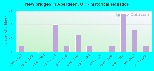
- New bridges - historical statistics
- 11900-1909
- 51930-1939
- 11940-1949
- 31950-1959
- 11960-1969
- 11980-1989
- 71990-1999
- 42000-2009
- 12010-2019

- Reconstructed bridges - Historical Statistics
- 21950-1959
- 01960-1969
- 11970-1979
- 11980-1989
- 11990-1999
- 12000-2009


- Bridge Condition - Deck
- 37.5%Very good
- 37.5%Good
- 18.8%Satisfactory
- 6.3%Fair

- Bridge Condition - Superstructure
- 37.5%Very good
- 31.3%Good
- 6.3%Satisfactory
- 6.3%Fair
- 18.8%Poor

- Bridge Condition - Substructure
- 37.5%Very good
- 31.3%Good
- 12.5%Satisfactory
- 12.5%Fair
- 6.3%Poor

- Bridge Condition - Channel
- 5.6%Excellent
- 44.4%Very good
- 33.3%Good
- 5.6%Satisfactory
- 11.1%Fair

- Bridge Condition - Culverts
- 33.3%Very good
- 33.3%Good
- 33.3%Fair
Find on map >> Show street view
Structure Number: 800333, Location: 0.186 MI S OF USR 52 (Lat: 38.651500, Lng: -83.758719), Route carried "on" structure: Business US 62B, Year Built: 1931, Year Reconstructed: 2001, Status: Posted for load, Structure Length: 96.44m (316.40ft), Average Daily Traffic: 6,478 (year 2017), Truck Traffic: 19%, Average Future Daily Traffic: 8,991 (year 2040), Design Load: H 15, Features Intersected: OHIO RIVER CSX RR LOCAL, Facility Carried by Structure: BUS.62
Minimum Vertical Clearance: 30+ m (98+ ft), Kilometerpoint: 0.000, Lanes on structure: 2, Lanes under structure: 6, Base Highway Network: Yes, Owner: State Highway Agency, Approaching Roadway Width: 6.1m (20.0ft), Navigation Control: Yes ( Vertical Clearance: 24.4m (80.1ft), Horizontal Clearance: 272.5m (894.0ft)), Material/Design: Steel, Design/Construction: Suspension, Number Of Spans In Main Unit: 3, Number Of Approach Spans: 12, Length of Maximum Span: 323.1m (1,060.0ft), Curb or Sidewalk Widths: Left: 1.4m (4.6ft), Right: 0.3m (1.0ft), Curb-To-Curb Width: 6.1m (20.0ft), Out-to-Out Width: 7.8m (25.6ft)
Condition: Deck: Satisfactory, Superstructure: Poor, Substructure: Fair, Channel: Very good, Operating Rating: 32.4 metric tons, Method Used To Determine Operating Rating: Load Factor (LF) rating reported by rating factor (RF) method using MS18 loading, Inventory Rating: 25.9 metric tons, Method Used To Determine Inventory Rating: Load Factor (LF) rating reported by rating factor (RF) method using MS18 loading, Structural Evaluation: Meets minimum limits, Deck Geometry: High priority of replacement, Underclear: High priority of corrective action, Waterway Adequacy: Equal to present desirable criteria, Approach Roadway Alignment: Better than present minimum criteria, Bridge Posting: Required (Relationship of Operating Rating to Maximum Legal Load: > 39.9% below), Designated Inspection Frequency: Every 24 months, Critical Feature Inspection Frequency: Every 24 months, Underwater Inspection Frequency: Every 60 months, Other Special Inspection Frequency: Every 12 months, Inspection Date: July 2021, Critical Feature Inspection Date: July 2021, Underwater Inspection Date: August 2017, Other Special Inspection Date: July 2021, Deck Structure Type: Concrete Cast-file-Place, Wearing Surface/Protective System: Wearing Surface: Monolithic Concrete
Find on map >> Show street view
Structure Number: 801232, Location: 1.06 MI W OF ABERDEEN (Lat: 38.696711, Lng: -83.782561), Route carried "on" structure: US 52, Year Built: 1955, Year Reconstructed: 1964, Status: Open, Structure Length: 8.66m (28.41ft), Average Daily Traffic: 6,397 (year 2015), Truck Traffic: 14%, Average Future Daily Traffic: 8,879 (year 2035), Design Load: HS 20, Features Intersected: BIG THREEMILE CREEK
Minimum Vertical Clearance: 30+ m (98+ ft), Kilometerpoint: 28.099, Lanes on structure: 2, Base Highway Network: Yes, Owner: State Highway Agency, Approaching Roadway Width: 12.8m (42.0ft), Material/Design: Steel continuous, Design/Construction: Stringer/Multi-beam, Number Of Spans In Main Unit: 5, Length of Maximum Span: 17.7m (58.1ft), Curb-To-Curb Width: 9.2m (30.2ft), Out-to-Out Width: 10.4m (34.1ft)
Condition: Deck: Satisfactory, Superstructure: Satisfactory, Substructure: Satisfactory, Channel: Good, Operating Rating: 42.1 metric tons, Method Used To Determine Operating Rating: Load Factor (LF) rating reported by rating factor (RF) method using MS18 loading, Inventory Rating: 32.4 metric tons, Method Used To Determine Inventory Rating: Load Factor (LF) rating reported by rating factor (RF) method using MS18 loading, Structural Evaluation: Equal to present minimum criteria, Deck Geometry: Meets minimum limits, Waterway Adequacy: Equal to present desirable criteria, Approach Roadway Alignment: Better than present minimum criteria, Designated Inspection Frequency: Every 12 months, Underwater Inspection Frequency: Every 60 months, Inspection Date: Febuary 2022, Underwater Inspection Date: July 2019, Deck Structure Type: Concrete Cast-file-Place, Wearing Surface/Protective System: Wearing Surface: Integral Concrete
Find on map >> Show street view
Structure Number: 801267, Location: ABERDEEN (Lat: 38.657250, Lng: -83.764911), Route carried "on" structure: US 52, Year Built: 1931, Year Reconstructed: 1955, Status: Open, Structure Length: 0.88m (2.89ft), Average Daily Traffic: 7,662 (year 2015), Truck Traffic: 5%, Average Future Daily Traffic: 10,635 (year 2035), Design Load: H 15, Features Intersected: FISHNG GUT CR-SUBMERGED
Minimum Vertical Clearance: 30+ m (98+ ft), Kilometerpoint: 32.831, Lanes on structure: 4, Base Highway Network: Yes, Owner: State Highway Agency, Approaching Roadway Width: 16.5m (54.1ft), Skew: 4 degrees, Material/Design: Concrete, Design/Construction: Culvert, Number Of Spans In Main Unit: 1, Length of Maximum Span: 7.3m (24.0ft)
Condition: Channel: Fair, Culverts: Fair, Operating Rating: 97.2 metric tons, Method Used To Determine Operating Rating: Load Factor (LF) rating reported by rating factor (RF) method using MS18 loading, Inventory Rating: 68.0 metric tons, Method Used To Determine Inventory Rating: Load Factor (LF) rating reported by rating factor (RF) method using MS18 loading, Structural Evaluation: Somewhat better than minimum adequacy, Waterway Adequacy: Meets minimum limits, Approach Roadway Alignment: Equal to present minimum criteria, Designated Inspection Frequency: Every 12 months, Underwater Inspection Frequency: Every 60 months, Inspection Date: January 2022, Underwater Inspection Date: July 2019
Find on map >> Show street view
Structure Number: 801305, Location: 0.527MI S OF USR 52 (Lat: 38.685069, Lng: -83.779789), Route carried "on" structure: US 68, Year Built: 2000, Status: Posted for load, Structure Length: 73.76m (241.99ft), Average Daily Traffic: 5,525 (year 2015), Truck Traffic: 15%, Design Load: HS 25 or greater, Features Intersected: OHIO RIVER CSX RR KY 8
Minimum Vertical Clearance: 30+ m (98+ ft), Kilometerpoint: 0.000, Lanes on structure: 2, Lanes under structure: 2, Base Highway Network: Yes, Owner: State Highway Agency, Approaching Roadway Width: 14.6m (47.9ft), Navigation Control: Yes ( Vertical Clearance: 22.9m (75.1ft), Horizontal Clearance: 304.8m (1,000.0ft)), Material/Design: Steel, Design/Construction: Stayed Girder, Number Of Spans In Main Unit: 5, Number Of Approach Spans: 3, Length of Maximum Span: 320.0m (1,049.9ft), Curb-To-Curb Width: 14.6m (47.9ft), Out-to-Out Width: 15.6m (51.2ft)
Condition: Deck: Satisfactory, Superstructure: Poor, Substructure: Fair, Channel: Very good, Operating Rating: 42.1 metric tons, Method Used To Determine Operating Rating: Load Factor (LF) rating reported by rating factor (RF) method using MS18 loading, Inventory Rating: 32.4 metric tons, Method Used To Determine Inventory Rating: Load Factor (LF) rating reported by rating factor (RF) method using MS18 loading, Structural Evaluation: Meets minimum limits, Deck Geometry: Superior to present desirable criteria, Underclear: Superior to present desirable criteria, Waterway Adequacy: Equal to present desirable criteria, Approach Roadway Alignment: Better than present minimum criteria, Designated Inspection Frequency: Every 24 months, Critical Feature Inspection Frequency: Every 24 months, Underwater Inspection Frequency: Every 60 months, Other Special Inspection Frequency: Every 12 months, Inspection Date: July 2021, Critical Feature Inspection Date: July 2021, Underwater Inspection Date: August 2017, Other Special Inspection Date: July 2021, Deck Structure Type: Concrete Cast-file-Place, Wearing Surface/Protective System: Wearing Surface: Latex Concrete
Find on map >> Show street view
Structure Number: 801313, Location: .14 MI N OF OHIO RIVER (Lat: 38.685831, Lng: -83.776839), Route carried "on" structure: US 62, Year Built: 1998, Status: Open, Structure Length: 5.82m (19.09ft), Average Daily Traffic: 5,525 (year 2015), Truck Traffic: 15%, Average Future Daily Traffic: 7,669 (year 2035), Design Load: HS 20+Mod, Features Intersected: OVER USR 52
Minimum Vertical Clearance: 30+ m (98+ ft), Kilometerpoint: 0.274, Lanes on structure: 2, Lanes under structure: 2, Base Highway Network: Yes, Owner: State Highway Agency, Approaching Roadway Width: 15.2m (49.9ft), Skew: 1 degrees, Material/Design: Prestressed concrete, Design/Construction: Stringer/Multi-beam, Number Of Spans In Main Unit: 3, Length of Maximum Span: 27.7m (90.9ft), Curb-To-Curb Width: 14.6m (47.9ft), Out-to-Out Width: 15.5m (50.9ft)
Condition: Deck: Good, Superstructure: Very good, Substructure: Good, Operating Rating: 42.1 metric tons, Method Used To Determine Operating Rating: Load Factor (LF) rating reported by rating factor (RF) method using MS18 loading, Inventory Rating: 32.4 metric tons, Method Used To Determine Inventory Rating: Load Factor (LF) rating reported by rating factor (RF) method using MS18 loading, Structural Evaluation: Better than present minimum criteria, Deck Geometry: Superior to present desirable criteria, Underclear: Better than present minimum criteria, Approach Roadway Alignment: Equal to present desirable criteria, Designated Inspection Frequency: Every 24 months, Inspection Date: April 2021, Deck Structure Type: Concrete Cast-file-Place, Wearing Surface/Protective System: Wearing Surface: Monolithic Concrete, Membrane: Built-up, Deck Protection: Epoxy Coated Reinforcing
Find on map >> Show street view
Structure Number: 803766, Location: .16 MI N OF JCT SR 41 (Lat: 38.672811, Lng: -83.747939), Route carried "on" structure: State highway 763, Year Built: 1989, Status: Open, Structure Length: 2.26m (7.41ft), Average Daily Traffic: 404 (year 2015), Truck Traffic: 1%, Average Future Daily Traffic: 561 (year 2035), Design Load: HS 20+Mod, Features Intersected: BIG THREE MILE CREEK
Minimum Vertical Clearance: 30+ m (98+ ft), Kilometerpoint: 0.257, Lanes on structure: 2, Owner: State Highway Agency, Approaching Roadway Width: 7.3m (24.0ft), Skew: 2 degrees, Material/Design: Prestressed concrete, Design/Construction: Box Beam or Girders - Multiple, Number Of Spans In Main Unit: 1, Length of Maximum Span: 21.0m (68.9ft), Curb-To-Curb Width: 9.8m (32.2ft), Out-to-Out Width: 9.8m (32.2ft)
Condition: Deck: Good, Superstructure: Good, Substructure: Very good, Channel: Good, Operating Rating: 51.8 metric tons, Method Used To Determine Operating Rating: Load and Resistance Factor Rating (LRFR) rating reported by rating factor(RF) method using HL-93 loadings, Inventory Rating: 22.7 metric tons, Method Used To Determine Inventory Rating: Load and Resistance Factor Rating (LRFR) rating reported by rating factor(RF) method using HL-93 loadings, Structural Evaluation: Equal to present minimum criteria, Deck Geometry: Equal to present minimum criteria, Waterway Adequacy: Equal to present desirable criteria, Approach Roadway Alignment: Equal to present minimum criteria, Designated Inspection Frequency: Every 24 months, Inspection Date: March 2021, Deck Structure Type: Concrete Cast-file-Place, Wearing Surface/Protective System: Wearing Surface: Epoxy Overlay, Deck Protection: Epoxy Coated Reinforcing
Find on map >> Show street view
Structure Number: 803774, Location: .58 MI N OF SR 41 (Lat: 38.677839, Lng: -83.749200), Route carried "on" structure: State highway 763, Year Built: 1996, Status: Open, Structure Length: 1.56m (5.12ft), Average Daily Traffic: 404 (year 2015), Truck Traffic: 1%, Average Future Daily Traffic: 561 (year 2035), Design Load: HS 20+Mod, Features Intersected: SLICKAWAY RUN
Minimum Vertical Clearance: 30+ m (98+ ft), Kilometerpoint: 0.901, Lanes on structure: 2, Owner: State Highway Agency, Approaching Roadway Width: 8.9m (29.2ft), Skew: 5 degrees, Material/Design: Steel, Design/Construction: Stringer/Multi-beam, Number Of Spans In Main Unit: 1, Length of Maximum Span: 14.9m (48.9ft), Curb-To-Curb Width: 8.5m (27.9ft), Out-to-Out Width: 8.5m (27.9ft)
Condition: Deck: Good, Superstructure: Good, Substructure: Satisfactory, Channel: Satisfactory, Operating Rating: 42.1 metric tons, Method Used To Determine Operating Rating: Load Factor (LF) rating reported by rating factor (RF) method using MS18 loading, Inventory Rating: 32.4 metric tons, Method Used To Determine Inventory Rating: Load Factor (LF) rating reported by rating factor (RF) method using MS18 loading, Structural Evaluation: Equal to present minimum criteria, Deck Geometry: Somewhat better than minimum adequacy, Waterway Adequacy: Equal to present desirable criteria, Approach Roadway Alignment: Better than present minimum criteria, Designated Inspection Frequency: Every 12 months, Inspection Date: January 2022, Deck Structure Type: Concrete Cast-file-Place, Wearing Surface/Protective System: Wearing Surface: Monolithic Concrete, Membrane: Built-up, Deck Protection: Epoxy Coated Reinforcing
Find on map >> Show street view
Structure Number: 803848, Location: 1.02 M N OF SR41 (Lat: 38.683661, Lng: -83.746581), Route carried "on" structure: State highway 763, Year Built: 2018, Status: Open, Structure Length: 3.44m (11.29ft), Average Daily Traffic: 380 (year 2015), Truck Traffic: 3%, Average Future Daily Traffic: 390 (year 2035), Design Load: HL 93, Features Intersected: SLICKWAY RUN
Minimum Vertical Clearance: 30+ m (98+ ft), Kilometerpoint: 1.585, Lanes on structure: 2, Owner: State Highway Agency, Approaching Roadway Width: 8.5m (27.9ft), Skew: 6 degrees, Material/Design: Concrete, Design/Construction: Culvert, Number Of Spans In Main Unit: 1, Length of Maximum Span: 11.0m (36.1ft)
Condition: Channel: Excellent, Culverts: Very good, Operating Rating: 42.1 metric tons, Method Used To Determine Operating Rating: Load and Resistance Factor Rating (LRFR) rating reported by rating factor(RF) method using HL-93 loadings, Inventory Rating: 32.4 metric tons, Method Used To Determine Inventory Rating: Load and Resistance Factor Rating (LRFR) rating reported by rating factor(RF) method using HL-93 loadings, Structural Evaluation: Equal to present desirable criteria, Waterway Adequacy: Better than present minimum criteria, Approach Roadway Alignment: Equal to present desirable criteria, Designated Inspection Frequency: Every 24 months, Inspection Date: March 2021, Wearing Surface/Protective System: Wearing Surface: Bituminous, Membrane: Preformed Fabric, Deck Protection: Epoxy Coated Reinforcing
Find on map >> Show street view
Structure Number: 803901, Location: 1.51 MI N OF SR 41 (Lat: 38.690839, Lng: -83.745189), Route carried "on" structure: State highway 763, Year Built: 1952, Year Reconstructed: 1985, Status: Open, Structure Length: 0.64m (2.10ft), Average Daily Traffic: 404 (year 2015), Truck Traffic: 1%, Average Future Daily Traffic: 561 (year 2035), Design Load: HS 20, Features Intersected: TRIB OF SLICKAWAY RUN
Minimum Vertical Clearance: 30+ m (98+ ft), Kilometerpoint: 2.430, Lanes on structure: 2, Owner: State Highway Agency, Approaching Roadway Width: 6.1m (20.0ft), Skew: 4 degrees, Material/Design: Wood or Timber, Design/Construction: Slab, Number Of Spans In Main Unit: 1, Length of Maximum Span: 4.6m (15.1ft), Curb-To-Curb Width: 6.0m (19.7ft), Out-to-Out Width: 6.2m (20.3ft)
Condition: Deck: Fair, Superstructure: Fair, Substructure: Poor, Channel: Fair, Operating Rating: 42.1 metric tons, Method Used To Determine Operating Rating: Allowable Stress (AS) rating reported by rating factor (RF) method using MS18 loading, Inventory Rating: 32.4 metric tons, Method Used To Determine Inventory Rating: Allowable Stress (AS) rating reported by rating factor (RF) method using MS18 loading, Structural Evaluation: Meets minimum limits, Deck Geometry: High priority of replacement, Waterway Adequacy: Equal to present minimum criteria, Approach Roadway Alignment: Somewhat better than minimum adequacy, Designated Inspection Frequency: Every 12 months, Inspection Date: January 2022, Deck Structure Type: Wood or Timber, Wearing Surface/Protective System: Wearing Surface: Bituminous
Find on map >> Show street view
Structure Number: 803952, Location: 4.23 MI N OF SR 41 (Lat: 38.719569, Lng: -83.725750), Route carried "on" structure: State highway 763, Year Built: 1993, Status: Open, Structure Length: 2.68m (8.79ft), Average Daily Traffic: 404 (year 2015), Truck Traffic: 1%, Average Future Daily Traffic: 561 (year 2035), Design Load: HS 20+Mod, Features Intersected: BEETLE CREEK
Minimum Vertical Clearance: 30+ m (98+ ft), Kilometerpoint: 6.695, Lanes on structure: 2, Owner: State Highway Agency, Approaching Roadway Width: 8.8m (28.9ft), Skew: 5 degrees, Material/Design: Steel, Design/Construction: Stringer/Multi-beam, Number Of Spans In Main Unit: 1, Length of Maximum Span: 24.1m (79.1ft), Curb-To-Curb Width: 8.6m (28.2ft), Out-to-Out Width: 8.6m (28.2ft)
Condition: Deck: Good, Superstructure: Very good, Substructure: Very good, Channel: Good, Operating Rating: 42.1 metric tons, Method Used To Determine Operating Rating: Load Factor (LF) rating reported by rating factor (RF) method using MS18 loading, Inventory Rating: 32.4 metric tons, Method Used To Determine Inventory Rating: Load Factor (LF) rating reported by rating factor (RF) method using MS18 loading, Structural Evaluation: Equal to present desirable criteria, Deck Geometry: Somewhat better than minimum adequacy, Waterway Adequacy: Equal to present desirable criteria, Approach Roadway Alignment: Equal to present minimum criteria, Designated Inspection Frequency: Every 24 months, Inspection Date: March 2021, Deck Structure Type: Concrete Cast-file-Place, Wearing Surface/Protective System: Wearing Surface: Monolithic Concrete, Membrane: Built-up, Deck Protection: Epoxy Coated Reinforcing
Find on map >> Show street view
Structure Number: 803987, Location: 1.39 M. N. OF ST.RT.41 (Lat: 38.688781, Lng: -83.745469), Route carried "on" structure: State highway 763, Year Built: 1996, Status: Open, Structure Length: 0.67m (2.20ft), Average Daily Traffic: 404 (year 2015), Truck Traffic: 1%, Average Future Daily Traffic: 561 (year 2035), Design Load: HS 20+Mod, Features Intersected: SLICKAWAY RUN
Minimum Vertical Clearance: 30+ m (98+ ft), Kilometerpoint: 2.189, Lanes on structure: 2, Owner: State Highway Agency, Approaching Roadway Width: 6.7m (22.0ft), Skew: 5 degrees, Material/Design: Concrete, Design/Construction: Culvert, Number Of Spans In Main Unit: 1, Length of Maximum Span: 6.1m (20.0ft)
Condition: Channel: Good, Culverts: Good, Operating Rating: 42.1 metric tons, Method Used To Determine Operating Rating: Load Factor (LF) rating reported by rating factor (RF) method using MS18 loading, Inventory Rating: 25.9 metric tons, Method Used To Determine Inventory Rating: Load Factor (LF) rating reported by rating factor (RF) method using MS18 loading, Structural Evaluation: Equal to present minimum criteria, Waterway Adequacy: Equal to present desirable criteria, Approach Roadway Alignment: Equal to present minimum criteria, Designated Inspection Frequency: Every 24 months, Inspection Date: March 2021
Find on map >> Show street view
Structure Number: 831328, Location: .39 MI. E. OF JCT. SR41 (Lat: 38.663211, Lng: -83.754669), Route carried "on" structure: County highway T0060, Year Built: 1900, Status: Posted for load, Structure Length: 1.59m (5.22ft), Average Daily Traffic: 175 (year 2015), Truck Traffic: 7%, Average Future Daily Traffic: 243 (year 2035), Design Load: HS 15, Features Intersected: FISHING GUT CREEK, Facility Carried by Structure: FISHING GUT ROAD
Minimum Vertical Clearance: 30+ m (98+ ft), Kilometerpoint: 0.628, Lanes on structure: 1, Owner: County Highway Agency, Approaching Roadway Width: 5.2m (17.1ft), Skew: 1 degrees, Material/Design: Steel, Design/Construction: Truss - Thru, Number Of Spans In Main Unit: 1, Length of Maximum Span: 14.0m (45.9ft), Curb-To-Curb Width: 4.9m (16.1ft), Out-to-Out Width: 4.9m (16.1ft)
Condition: Deck: Good, Superstructure: Poor, Substructure: Good, Channel: Good, Operating Rating: 32.4 metric tons, Method Used To Determine Operating Rating: Allowable Stress (AS) rating reported by rating factor (RF) method using MS18 loading, Inventory Rating: 25.9 metric tons, Method Used To Determine Inventory Rating: Allowable Stress (AS) rating reported by rating factor (RF) method using MS18 loading, Structural Evaluation: Meets minimum limits, Deck Geometry: High priority of replacement, Waterway Adequacy: Equal to present desirable criteria, Approach Roadway Alignment: Meets minimum limits, Bridge Posting: Required (Relationship of Operating Rating to Maximum Legal Load: > 39.9% below), Designated Inspection Frequency: Every 12 months, Critical Feature Inspection Frequency: Every 24 months, Inspection Date: August 2021, Critical Feature Inspection Date: August 2020, Deck Structure Type: Concrete Cast-file-Place, Wearing Surface/Protective System: Wearing Surface: Bituminous
Find on map >> Show street view
Structure Number: 831352, Location: 1.15 MI. E. OF JCT. SR41 (Lat: 38.657661, Lng: -83.743531), Route carried "on" structure: County highway T0060, Year Built: 1940, Year Reconstructed: 1970, Status: Open, Structure Length: 0.73m (2.40ft), Average Daily Traffic: 175 (year 2015), Truck Traffic: 7%, Average Future Daily Traffic: 243 (year 2035), Design Load: HS 20, Features Intersected: FISHING GUT CREEK, Facility Carried by Structure: FISHING GUT ROAD
Minimum Vertical Clearance: 30+ m (98+ ft), Kilometerpoint: 1.851, Lanes on structure: 1, Owner: County Highway Agency, Approaching Roadway Width: 5.2m (17.1ft), Skew: 3 degrees, Material/Design: Steel, Design/Construction: Stringer/Multi-beam, Number Of Spans In Main Unit: 1, Length of Maximum Span: 7.3m (24.0ft), Curb-To-Curb Width: 4.8m (15.7ft), Out-to-Out Width: 5.0m (16.4ft)
Condition: Deck: Very good, Superstructure: Good, Substructure: Good, Channel: Good, Operating Rating: 48.6 metric tons, Method Used To Determine Operating Rating: Load Factor (LF) rating reported by rating factor (RF) method using MS18 loading, Inventory Rating: 29.2 metric tons, Method Used To Determine Inventory Rating: Load Factor (LF) rating reported by rating factor (RF) method using MS18 loading, Structural Evaluation: Better than present minimum criteria, Deck Geometry: High priority of corrective action, Waterway Adequacy: Equal to present minimum criteria, Approach Roadway Alignment: Equal to present minimum criteria, Designated Inspection Frequency: Every 24 months, Inspection Date: November 2021, Deck Structure Type: Concrete Cast-file-Place, Wearing Surface/Protective System: Wearing Surface: Monolithic Concrete
Find on map >> Show street view
Structure Number: 832383, Location: 1.14 MI. S. OF JCT. C49B (Lat: 38.711139, Lng: -83.744861), Route carried "on" structure: County highway T0247, Year Built: 1958, Status: Open, Structure Length: 1.07m (3.51ft), Average Daily Traffic: 20 (year 1951), Average Future Daily Traffic: 28 (year 1971), Design Load: HS 15, Features Intersected: BEETLE CREEK, Facility Carried by Structure: EAST FORK ROAD
Minimum Vertical Clearance: 30+ m (98+ ft), Kilometerpoint: 4.023, Lanes on structure: 1, Owner: County Highway Agency, Approaching Roadway Width: 4.9m (16.1ft), Material/Design: Steel, Design/Construction: Stringer/Multi-beam, Number Of Spans In Main Unit: 1, Length of Maximum Span: 9.8m (32.2ft), Curb-To-Curb Width: 4.8m (15.7ft), Out-to-Out Width: 4.9m (16.1ft)
Condition: Deck: Very good, Superstructure: Good, Substructure: Good, Channel: Very good, Operating Rating: 32.4 metric tons, Method Used To Determine Operating Rating: Allowable Stress (AS) rating reported by rating factor (RF) method using MS18 loading, Inventory Rating: 25.9 metric tons, Method Used To Determine Inventory Rating: Allowable Stress (AS) rating reported by rating factor (RF) method using MS18 loading, Structural Evaluation: Equal to present minimum criteria, Deck Geometry: Equal to present desirable criteria, Waterway Adequacy: Equal to present desirable criteria, Approach Roadway Alignment: Equal to present minimum criteria, Designated Inspection Frequency: Every 24 months, Inspection Date: October 2021, Deck Structure Type: Concrete Cast-file-Place, Wearing Surface/Protective System: Wearing Surface: Monolithic Concrete
Find on map >> Show street view
Structure Number: 834769, Location: .05 MI S OF JCT C49 (Lat: 38.719319, Lng: -83.761569), Route carried "on" structure: County highway T0346, Year Built: 1991, Status: Open, Structure Length: 0.64m (2.10ft), Average Daily Traffic: 155 (year 2015), Truck Traffic: 8%, Average Future Daily Traffic: 215 (year 2035), Design Load: HS 20, Features Intersected: STREAM, Facility Carried by Structure: LOWER EAST FORK RD
Minimum Vertical Clearance: 30+ m (98+ ft), Kilometerpoint: 0.016, Lanes on structure: 2, Owner: County Highway Agency, Approaching Roadway Width: 4.3m (14.1ft), Skew: 1 degrees, Material/Design: Concrete, Design/Construction: Box Beam or Girders - Multiple, Number Of Spans In Main Unit: 1, Length of Maximum Span: 6.4m (21.0ft), Curb-To-Curb Width: 6.4m (21.0ft), Out-to-Out Width: 6.4m (21.0ft)
Condition: Deck: Very good, Superstructure: Very good, Substructure: Very good, Channel: Very good, Operating Rating: 42.1 metric tons, Method Used To Determine Operating Rating: Load Factor (LF) rating reported by rating factor (RF) method using MS18 loading, Inventory Rating: 29.2 metric tons, Method Used To Determine Inventory Rating: Load Factor (LF) rating reported by rating factor (RF) method using MS18 loading, Structural Evaluation: Better than present minimum criteria, Deck Geometry: Meets minimum limits, Waterway Adequacy: Superior to present desirable criteria, Approach Roadway Alignment: Superior to present desirable criteria, Designated Inspection Frequency: Every 24 months, Inspection Date: October 2021, Deck Structure Type: Concrete Cast-file-Place, Wearing Surface/Protective System: Wearing Surface: Bituminous
Find on map >> Show street view
Structure Number: 834882, Location: .23 MI. W. JCT. C49B (Lat: 38.723969, Lng: -83.732069), Route carried "on" structure: County highway C0013, Year Built: 1993, Status: Open, Structure Length: 0.91m (2.99ft), Average Daily Traffic: 41 (year 2015), Truck Traffic: 7%, Average Future Daily Traffic: 57 (year 2035), Design Load: HS 20+Mod, Features Intersected: STREAM, Facility Carried by Structure: NORTHPOLE RD
Minimum Vertical Clearance: 30+ m (98+ ft), Kilometerpoint: 11.233, Lanes on structure: 2, Owner: County Highway Agency, Approaching Roadway Width: 7.9m (25.9ft), Skew: 4 degrees, Material/Design: Concrete, Design/Construction: Box Beam or Girders - Multiple, Number Of Spans In Main Unit: 1, Length of Maximum Span: 8.8m (28.9ft), Curb-To-Curb Width: 7.3m (24.0ft), Out-to-Out Width: 7.3m (24.0ft)
Condition: Deck: Good, Superstructure: Good, Substructure: Good, Channel: Very good, Operating Rating: 38.9 metric tons, Method Used To Determine Operating Rating: Load Factor (LF) rating reported by rating factor (RF) method using MS18 loading, Inventory Rating: 22.7 metric tons, Method Used To Determine Inventory Rating: Load Factor (LF) rating reported by rating factor (RF) method using MS18 loading, Structural Evaluation: Equal to present minimum criteria, Deck Geometry: Equal to present minimum criteria, Waterway Adequacy: Superior to present desirable criteria, Approach Roadway Alignment: Equal to present desirable criteria, Designated Inspection Frequency: Every 24 months, Inspection Date: October 2021, Deck Structure Type: Concrete Cast-file-Place, Wearing Surface/Protective System: Wearing Surface: Bituminous
Find on map >> Show street view
Structure Number: 83539, Location: .9 M. E. OF ST. RT. 41 (Lat: 38.659881, Lng: -83.746719), Route carried "on" structure: County highway T0060, Year Built: 2002, Status: Open, Structure Length: 1.34m (4.40ft), Average Daily Traffic: 175 (year 2015), Truck Traffic: 7%, Average Future Daily Traffic: 243 (year 2035), Design Load: HS 20+Mod, Features Intersected: FISHING GUT CREEK, Facility Carried by Structure: FISHING GUT RD.
Minimum Vertical Clearance: 30+ m (98+ ft), Kilometerpoint: 1.448, Lanes on structure: 2, Owner: County Highway Agency, Approaching Roadway Width: 6.1m (20.0ft), Skew: 4 degrees, Material/Design: Prestressed concrete, Design/Construction: Box Beam or Girders - Multiple, Number Of Spans In Main Unit: 1, Length of Maximum Span: 13.1m (43.0ft), Curb-To-Curb Width: 8.5m (27.9ft), Out-to-Out Width: 8.5m (27.9ft)
Condition: Deck: Very good, Superstructure: Very good, Substructure: Very good, Channel: Very good, Operating Rating: 42.1 metric tons, Method Used To Determine Operating Rating: Load Factor (LF) rating reported by rating factor (RF) method using MS18 loading, Inventory Rating: 32.4 metric tons, Method Used To Determine Inventory Rating: Load Factor (LF) rating reported by rating factor (RF) method using MS18 loading, Structural Evaluation: Equal to present desirable criteria, Deck Geometry: Equal to present minimum criteria, Waterway Adequacy: Equal to present desirable criteria, Approach Roadway Alignment: Equal to present desirable criteria, Designated Inspection Frequency: Every 24 months, Inspection Date: November 2021, Deck Structure Type: Concrete Cast-file-Place, Wearing Surface/Protective System: Wearing Surface: Bituminous, Deck Protection: Other
Find on map >> Show street view
Structure Number: 835528, Location: 200 FT. W. OF SR763 (Lat: 38.675139, Lng: -83.749931), Route carried "on" structure: County highway T0251, Year Built: 2007, Status: Open, Structure Length: 0.91m (2.99ft), Average Daily Traffic: 951 (year 2015), Truck Traffic: 5%, Average Future Daily Traffic: 1,320 (year 2035), Design Load: HS 20+Mod, Features Intersected: STREAM, Facility Carried by Structure: STRINGTOWN RD.
Minimum Vertical Clearance: 30+ m (98+ ft), Kilometerpoint: 3.798, Lanes on structure: 2, Owner: County Highway Agency, Approaching Roadway Width: 3.7m (12.1ft), Skew: 1 degrees, Material/Design: Concrete, Design/Construction: Box Beam or Girders - Multiple, Number Of Spans In Main Unit: 1, Length of Maximum Span: 8.8m (28.9ft), Curb-To-Curb Width: 6.1m (20.0ft), Out-to-Out Width: 8.2m (26.9ft)
Condition: Deck: Very good, Superstructure: Very good, Substructure: Very good, Channel: Very good, Operating Rating: 42.1 metric tons, Method Used To Determine Operating Rating: Load Factor (LF) rating reported by rating factor (RF) method using MS18 loading, Inventory Rating: 32.4 metric tons, Method Used To Determine Inventory Rating: Load Factor (LF) rating reported by rating factor (RF) method using MS18 loading, Structural Evaluation: Equal to present desirable criteria, Deck Geometry: High priority of corrective action, Waterway Adequacy: Equal to present desirable criteria, Approach Roadway Alignment: Equal to present desirable criteria, Designated Inspection Frequency: Every 24 months, Inspection Date: October 2021, Deck Structure Type: Concrete Cast-file-Place, Wearing Surface/Protective System: Wearing Surface: Bituminous, Deck Protection: Other
Find on map >> Show street view
Structure Number: 835579, Location: .44 MI. N. OF US 52 (Lat: 38.687981, Lng: -83.771919), Route carried "on" structure: County highway T0307, Year Built: 1963, Year Reconstructed: 2005, Status: Open, Structure Length: 3.66m (12.01ft), Average Daily Traffic: 226 (year 2015), Truck Traffic: 5%, Average Future Daily Traffic: 314 (year 2035), Design Load: HS 20+Mod, Features Intersected: THREE MILE CREEK, Facility Carried by Structure: FLAUGHER HILL RD.
Minimum Vertical Clearance: 30+ m (98+ ft), Kilometerpoint: 0.708, Lanes on structure: 2, Owner: County Highway Agency, Approaching Roadway Width: 4.9m (16.1ft), Material/Design: Prestressed concrete, Design/Construction: Box Beam or Girders - Multiple, Number Of Spans In Main Unit: 2, Length of Maximum Span: 17.7m (58.1ft), Curb-To-Curb Width: 5.5m (18.0ft), Out-to-Out Width: 5.5m (18.0ft)
Condition: Deck: Very good, Superstructure: Very good, Substructure: Very good, Channel: Very good, Operating Rating: 42.1 metric tons, Method Used To Determine Operating Rating: Allowable Stress (AS) rating reported by rating factor (RF) method using MS18 loading, Inventory Rating: 32.4 metric tons, Method Used To Determine Inventory Rating: Allowable Stress (AS) rating reported by rating factor (RF) method using MS18 loading, Structural Evaluation: Equal to present desirable criteria, Deck Geometry: High priority of corrective action, Waterway Adequacy: Superior to present desirable criteria, Approach Roadway Alignment: Equal to present minimum criteria, Designated Inspection Frequency: Every 24 months, Inspection Date: October 2021, Deck Structure Type: Concrete Cast-file-Place, Wearing Surface/Protective System: Wearing Surface: Epoxy Overlay, Deck Protection: Other
Find on map >> Show street view
Structure Number: 800333, Location: 0.186 MI S OF USR 52 (Lat: 38.651500, Lng: -83.758719), Route carried "under" structure: City street SECON, Year Built: 1931, Structure Length: 0. m, Features Intersected: overlap 41, Facility Carried by Structure: BUS.62
Minimum Vertical Clearance: 4.12m (13.52ft), Kilometerpoint: 0.161, Lanes on structure: 2, Lanes under structure: 6, Material/Design: Steel, Design/Construction: Suspension, Length of Maximum Span: 323.1m (1,060.0ft)
Find on map >> Show street view
Structure Number: 800333, Location: 0.186 MI S OF USR 52 (Lat: 38.651500, Lng: -83.758719), Route carried "under" structure: City street FRONT, Year Built: 1931, Structure Length: 0. m, Features Intersected: ST RTE 41, Facility Carried by Structure: BUS.62
Minimum Vertical Clearance: 4.57m (14.99ft), Kilometerpoint: 1.609, Lanes on structure: 2, Lanes under structure: 6, Material/Design: Steel, Design/Construction: Suspension, Length of Maximum Span: 323.1m (1,060.0ft)
Find on map >> Show street view
Structure Number: 800333, Location: 0.186 MI S OF USR 52 (Lat: 38.651500, Lng: -83.758719), Route carried "under" structure: City street SECKY, Year Built: 1931, Structure Length: 0. m, Features Intersected: ST RTE 41, Facility Carried by Structure: BUS.62
Minimum Vertical Clearance: 4.57m (14.99ft), Kilometerpoint: 1.609, Lanes on structure: 2, Lanes under structure: 6, Material/Design: Steel, Design/Construction: Suspension, Length of Maximum Span: 323.1m (1,060.0ft)
Find on map >> Show street view
Structure Number: 801305, Location: 0.527MI S OF USR 52 (Lat: 38.685069, Lng: -83.779789), Route carried "under" structure: State highway KY-8, Year Built: 2000, Structure Length: 0. m, Average Daily Traffic: 1,336 (year 2015), Features Intersected: USR-62/68 WIL HARSH BRG, Facility Carried by Structure: US ROUTES 62/68
Minimum Vertical Clearance: 8.13m (26.67ft), Kilometerpoint: 14.800, Lanes on structure: 2, Lanes under structure: 2, Material/Design: Steel, Design/Construction: Stayed Girder, Length of Maximum Span: 320.0m (1,049.9ft)
Find on map >> Show street view
Structure Number: 801313, Location: .14 MI N OF OHIO RIVER (Lat: 38.685831, Lng: -83.776839), Route carried "under" structure: US 52, Year Built: 1998, Structure Length: 0. m, Average Daily Traffic: 6,397 (year 2015), Truck Traffic: 14%, Features Intersected: STATE ROUTE 62, Facility Carried by Structure: US ROUTE 62
Minimum Vertical Clearance: 5.23m (17.16ft), Kilometerpoint: 28.968, Lanes on structure: 2, Lanes under structure: 2, Material/Design: Prestressed concrete, Design/Construction: Stringer/Multi-beam, Length of Maximum Span: 27.7m (90.9ft)