Bridge Statistics for Acton, Massachusetts (MA)
Condition, Traffic, Stress, Structural Evaluation, Project Costs
- National Bridge Inventory (NBI) Statistics
- 26Number of bridges
- 95ft / 28.9mTotal length
- $20,832,000Total costs
- 392,003Total average daily traffic
- 10,280Total average daily truck traffic
- National Bridge Inventory (NBI) Registered Bridges for Acton
- No street view available for this location
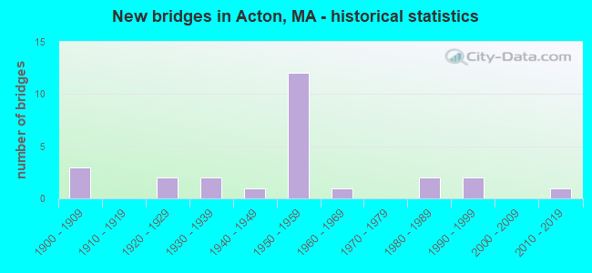
- New bridges - historical statistics
- 31900-1909
- 21920-1929
- 21930-1939
- 11940-1949
- 121950-1959
- 11960-1969
- 21980-1989
- 21990-1999
- 12010-2019

- Reconstructed bridges - Historical Statistics
- 11980-1989
- 51990-1999


- Bridge Condition - Deck
- 18.2%Good
- 72.7%Satisfactory
- 9.1%Fair

- Bridge Condition - Superstructure
- 23.1%Good
- 23.1%Satisfactory
- 53.8%Fair

- Bridge Condition - Substructure
- 38.5%Good
- 38.5%Satisfactory
- 23.1%Fair

- Bridge Condition - Channel
- 14.3%Good
- 35.7%Satisfactory
- 21.4%Fair
- 28.6%Poor

- Bridge Condition - Culverts
- 50.0%Good
- 33.3%Satisfactory
- 16.7%Fair
Find on map >> Show street view
Structure Number: A0200128RDOTNBI, Location: .1 MI NW. OF CONCORD LINE (Lat: 42.440939, Lng: -71.429483), Route carried "on" structure: State highway 62, Year Built: 1953, Status: Posted for load, Structure Length: 2.37m (7.78ft), Average Daily Traffic: 12,997 (year 2019), Truck Traffic: 2%, Average Future Daily Traffic: 43,905 (year 2033), Design Load: H 20, Features Intersected: WATER ASSABET RIVER
Minimum Vertical Clearance: 30+ m (98+ ft), Kilometerpoint: 70.384, Lanes on structure: 3, Base Highway Network: Yes, Owner: State Highway Agency, Approaching Roadway Width: 12.2m (40.0ft), Skew: 1 degrees, Material/Design: Steel, Design/Construction: Stringer/Multi-beam, Number Of Spans In Main Unit: 1, Length of Maximum Span: 22.6m (74.1ft), Curb or Sidewalk Widths: Left: 0.8m (2.6ft), Right: 2.0m (6.6ft), Curb-To-Curb Width: 12.2m (40.0ft), Out-to-Out Width: 15.0m (49.2ft)
Condition: Deck: Satisfactory, Superstructure: Fair, Substructure: Fair, Channel: Poor, Operating Rating: 53.1 metric tons, Method Used To Determine Operating Rating: Load Factor (LF), Inventory Rating: 32.8 metric tons, Method Used To Determine Inventory Rating: Load Factor (LF), Structural Evaluation: Somewhat better than minimum adequacy, Deck Geometry: Meets minimum limits, Waterway Adequacy: Equal to present desirable criteria, Approach Roadway Alignment: Equal to present desirable criteria, Length Of Structure Improvement: 2.40m (7.87ft), Designated Inspection Frequency: Every 12 months, Underwater Inspection Frequency: Every 36 months, Other Special Inspection Frequency: Every 12 months, Inspection Date: Febuary 2022, Underwater Inspection Date: May 2019, Bridge Improvement Cost: $1,415,000, Roadway Improvement Cost: $142,000, Total Project Cost: $2,123,000 ( Estimate for 2022), Deck Structure Type: Concrete Cast-file-Place, Wearing Surface/Protective System: Wearing Surface: Bituminous, Membrane: Built-up
Find on map >> Show street view
Structure Number: A0200429ADOT634, Location: 100 FT S OF SCHOOL ST (Lat: 42.460067, Lng: -71.454461), Route carried "on" structure: State highway 27, Year Built: 1906, Year Reconstructed: 1997, Status: Open, Structure Length: 2.60m (8.53ft), Average Daily Traffic: 13,600 (year 2014), Truck Traffic: 5%, Average Future Daily Traffic: 21,478 (year 2033), Design Load: HS 20, Features Intersected: RR MBTA/BMRR
Minimum Vertical Clearance: 30+ m (98+ ft), Kilometerpoint: 99.786, Lanes on structure: 3, Base Highway Network: Yes, Owner: State Highway Agency, Approaching Roadway Width: 11.0m (36.1ft), Skew: 1 degrees, Material/Design: Prestressed concrete continuous, Design/Construction: Slab, Number Of Spans In Main Unit: 3, Length of Maximum Span: 13.1m (43.0ft), Curb or Sidewalk Widths: Left: 1.6m (5.2ft), Right: 1.6m (5.2ft), Curb-To-Curb Width: 11.0m (36.1ft), Out-to-Out Width: 15.2m (49.9ft)
Condition: Deck: Satisfactory, Superstructure: Satisfactory, Substructure: Good, Operating Rating: 55.0 metric tons, Method Used To Determine Operating Rating: Load Factor (LF), Inventory Rating: 46.3 metric tons, Method Used To Determine Inventory Rating: Load Factor (LF), Structural Evaluation: Equal to present minimum criteria, Deck Geometry: High priority of replacement, Underclear: Meets minimum limits, Approach Roadway Alignment: Equal to present minimum criteria, Length Of Structure Improvement: 2.70m (8.86ft), Designated Inspection Frequency: Every 24 months, Inspection Date: January 2022, Bridge Improvement Cost: $1,884,000, Roadway Improvement Cost: $189,000, Total Project Cost: $2,827,000 ( Estimate for 2022), Deck Structure Type: Concrete Precast Panels, Wearing Surface/Protective System: Wearing Surface: Bituminous, Membrane: Built-up, Deck Protection: Epoxy Coated Reinforcing
Find on map >> Show street view
Structure Number: A0200628KDOTNBI, Location: 1.5 MI W RT 2 & ST 111 (Lat: 42.475944, Lng: -71.467742), Route carried "on" structure: State highway 111, Year Built: 1907, Year Reconstructed: 1998, Status: Open, Structure Length: 0.67m (2.20ft), Average Daily Traffic: 41,000 (year 1996), Truck Traffic: 3%, Average Future Daily Traffic: 12,161 (year 2031), Features Intersected: WATER FORT POND BROOK
Minimum Vertical Clearance: 30+ m (98+ ft), Kilometerpoint: 5.826, Lanes on structure: 2, Owner: State Highway Agency, Approaching Roadway Width: 7.9m (25.9ft), Skew: 1 degrees, Material/Design: Concrete continuous, Design/Construction: Tee Beam, Number Of Spans In Main Unit: 2, Length of Maximum Span: 2.7m (8.9ft), Curb or Sidewalk Widths: Left: 0.0m, Right: 1.2m (3.9ft), Curb-To-Curb Width: 8.1m (26.6ft), Out-to-Out Width: 11.0m (36.1ft)
Condition: Deck: Satisfactory, Superstructure: Fair, Substructure: Satisfactory, Channel: Satisfactory, Operating Rating: 74.9 metric tons, Method Used To Determine Operating Rating: Load Factor (LF), Inventory Rating: 44.9 metric tons, Method Used To Determine Inventory Rating: Load Factor (LF), Structural Evaluation: Somewhat better than minimum adequacy, Deck Geometry: High priority of replacement, Waterway Adequacy: Equal to present desirable criteria, Approach Roadway Alignment: Equal to present desirable criteria, Length Of Structure Improvement: 0.70m (2.30ft), Designated Inspection Frequency: Every 24 months, Underwater Inspection Frequency: Every 24 months, Inspection Date: December 2020, Underwater Inspection Date: January 2021, Bridge Improvement Cost: $303,000, Roadway Improvement Cost: $31,000, Total Project Cost: $455,000 ( Estimate for 2022), Deck Structure Type: Concrete Cast-file-Place, Wearing Surface/Protective System: Wearing Surface: Bituminous
Find on map >> Show street view
Structure Number: A0200723XMUNNBI, Location: 100 FT SE OF SCHOOL ST (Lat: 42.463756, Lng: -71.422706), Route carried "on" structure: City street , Year Built: 1928, Status: Open, Structure Length: 0.79m (2.59ft), Average Daily Traffic: 5,424 (year 2018), Truck Traffic: 5%, Average Future Daily Traffic: 5,212 (year 2032), Features Intersected: WATER FORT POND BROOK, Facility Carried by Structure: HWY LAWSBROOK RD
Minimum Vertical Clearance: 30+ m (98+ ft), Kilometerpoint: 0.032, Lanes on structure: 2, Owner: Town or Township Highway Agency, Approaching Roadway Width: 7.3m (24.0ft), Material/Design: Concrete, Design/Construction: Tee Beam, Number Of Spans In Main Unit: 1, Length of Maximum Span: 7.0m (23.0ft), Curb or Sidewalk Widths: Left: 0.1m (0.3ft), Right: 0.1m (0.3ft), Curb-To-Curb Width: 7.9m (25.9ft), Out-to-Out Width: 8.7m (28.5ft)
Condition: Deck: Satisfactory, Superstructure: Fair, Substructure: Good, Channel: Satisfactory, Operating Rating: 81.4 metric tons, Method Used To Determine Operating Rating: Load Factor (LF), Inventory Rating: 48.7 metric tons, Method Used To Determine Inventory Rating: Load Factor (LF), Structural Evaluation: Somewhat better than minimum adequacy, Deck Geometry: High priority of replacement, Waterway Adequacy: Better than present minimum criteria, Approach Roadway Alignment: Equal to present minimum criteria, Length Of Structure Improvement: 0.80m (2.62ft), Designated Inspection Frequency: Every 12 months, Underwater Inspection Frequency: Every 36 months, Other Special Inspection Frequency: Every 12 months, Inspection Date: July 2021, Underwater Inspection Date: September 2021, Other Special Inspection Date: July 2021, Bridge Improvement Cost: $274,000, Roadway Improvement Cost: $28,000, Total Project Cost: $412,000 ( Estimate for 2022), Deck Structure Type: Concrete Cast-file-Place, Wearing Surface/Protective System: Wearing Surface: Bituminous
Find on map >> Show street view
Structure Number: A02008255MUNNBI, Location: @ CORNER OF CARRIAGE ST (Lat: 42.456856, Lng: -71.436844), Route carried "on" structure: City street , Year Built: 1937, Status: Open, Structure Length: 1.58m (5.18ft), Average Daily Traffic: 600 (year 2021), Truck Traffic: 2%, Average Future Daily Traffic: 3,159 (year 2032), Features Intersected: WATER FORT POND BROOK, Facility Carried by Structure: HWY RIVER ST
Minimum Vertical Clearance: 30+ m (98+ ft), Kilometerpoint: 1.288, Lanes on structure: 2, Owner: Town or Township Highway Agency, Approaching Roadway Width: 5.8m (19.0ft), Skew: 3 degrees, Material/Design: Steel, Design/Construction: Arch - Deck, Number Of Spans In Main Unit: 1, Length of Maximum Span: 7.0m (23.0ft), Curb-To-Curb Width: 6.2m (20.3ft), Out-to-Out Width: 7.6m (24.9ft)
Condition: Superstructure: Satisfactory, Substructure: Good, Channel: Fair, Operating Rating: 32.4 metric tons, Method Used To Determine Operating Rating: Allowable Stress (AS), Inventory Rating: 23.1 metric tons, Method Used To Determine Inventory Rating: Allowable Stress (AS), Structural Evaluation: Equal to present minimum criteria, Deck Geometry: High priority of corrective action, Waterway Adequacy: Better than present minimum criteria, Approach Roadway Alignment: Better than present minimum criteria, Length Of Structure Improvement: 1.60m (5.25ft), Designated Inspection Frequency: Every 24 months, Inspection Date: December 2021, Bridge Improvement Cost: $478,000, Roadway Improvement Cost: $48,000, Total Project Cost: $718,000 ( Estimate for 2022)
Find on map >> Show street view
Structure Number: A0200923YMUNNBI, Location: .25 MI. W OF RTE. 2A (Lat: 42.493975, Lng: -71.420139), Route carried "on" structure: City street , Year Built: 1938, Status: Open, Structure Length: 0.79m (2.59ft), Average Daily Traffic: 8,060 (year 2013), Truck Traffic: 8%, Average Future Daily Traffic: 12,729 (year 2032), Features Intersected: WATER NASHOBA BROOK, Facility Carried by Structure: HWY BROOK ST
Minimum Vertical Clearance: 30+ m (98+ ft), Kilometerpoint: 0.354, Lanes on structure: 2, Owner: Town or Township Highway Agency, Approaching Roadway Width: 8.2m (26.9ft), Material/Design: Steel, Design/Construction: Culvert, Number Of Spans In Main Unit: 2, Length of Maximum Span: 3.3m (10.8ft), Curb or Sidewalk Widths: Left: 0.7m (2.3ft), Right: 0.9m (3.0ft), Curb-To-Curb Width: 8.2m (26.9ft), Out-to-Out Width: 11.0m (36.1ft)
Condition: Channel: Fair, Culverts: Satisfactory, Inventory Rating: 99.2 metric tons, Method Used To Determine Inventory Rating: Load Factor (LF), Structural Evaluation: Equal to present minimum criteria, Deck Geometry: High priority of replacement, Waterway Adequacy: Better than present minimum criteria, Approach Roadway Alignment: Better than present minimum criteria, Length Of Structure Improvement: 0.60m (1.97ft), Designated Inspection Frequency: Every 24 months, Underwater Inspection Frequency: Every 36 months, Inspection Date: December 2021, Underwater Inspection Date: July 2021, Bridge Improvement Cost: $449,000, Roadway Improvement Cost: $45,000, Total Project Cost: $674,000 ( Estimate for 2022)
Find on map >> Show street view
Structure Number: A02010BTTMUNNBI, Location: CORNER OF CLOVER HILL RD (Lat: 42.458011, Lng: -71.433656), Route carried "on" structure: City street , Year Built: 2018, Status: Open, Structure Length: 0.70m (2.30ft), Average Daily Traffic: 3,000 (year 2018), Truck Traffic: 5%, Design Load: HS 20, Features Intersected: WATER FORT POND BROOK, Facility Carried by Structure: HWY PARKER ST
Minimum Vertical Clearance: 30+ m (98+ ft), Kilometerpoint: 0.241, Lanes on structure: 2, Owner: Town or Township Highway Agency, Approaching Roadway Width: 6.7m (22.0ft), Skew: 4 degrees, Material/Design: Concrete, Design/Construction: Frame, Number Of Spans In Main Unit: 1, Length of Maximum Span: 7.0m (23.0ft), Curb or Sidewalk Widths: Left: 0.0m, Right: 1.7m (5.6ft), Curb-To-Curb Width: 6.7m (22.0ft), Out-to-Out Width: 9.0m (29.5ft)
Condition: Deck: Good, Superstructure: Good, Substructure: Good, Channel: Good, Operating Rating: 58.3 metric tons, Method Used To Determine Operating Rating: Load and Resistance Factor Rating (LRFR) rating reported by rating factor(RF) method using HL-93 loadings, Inventory Rating: 45.4 metric tons, Method Used To Determine Inventory Rating: Load and Resistance Factor Rating (LRFR) rating reported by rating factor(RF) method using HL-93 loadings, Structural Evaluation: Better than present minimum criteria, Deck Geometry: High priority of replacement, Waterway Adequacy: Better than present minimum criteria, Approach Roadway Alignment: Equal to present desirable criteria, Designated Inspection Frequency: Every 24 months, Inspection Date: June 2020
Find on map >> Show street view
Structure Number: A02011257MUNNBI, Location: 500 FT S OF RT 2A (Lat: 42.475147, Lng: -71.410894), Route carried "on" structure: City street , Year Built: 1997, Status: Open, Structure Length: 1.46m (4.79ft), Average Daily Traffic: 1,040 (year 2014), Truck Traffic: 3%, Average Future Daily Traffic: 1,642 (year 2033), Design Load: HS 20, Features Intersected: WATER NASHOBA BROOK, Facility Carried by Structure: HWY WETHERBEE ST
Minimum Vertical Clearance: 30+ m (98+ ft), Kilometerpoint: 0.338, Lanes on structure: 2, Owner: Town or Township Highway Agency, Approaching Roadway Width: 7.5m (24.6ft), Skew: 4 degrees, Material/Design: Concrete, Design/Construction: Culvert, Number Of Spans In Main Unit: 3, Length of Maximum Span: 3.0m (9.8ft), Curb or Sidewalk Widths: Left: 0.2m (0.7ft), Right: 1.3m (4.3ft), Curb-To-Curb Width: 7.5m (24.6ft), Out-to-Out Width: 9.8m (32.2ft)
Condition: Channel: Fair, Culverts: Good, Operating Rating: 59.6 metric tons, Method Used To Determine Operating Rating: Load Factor (LF), Inventory Rating: 35.7 metric tons, Method Used To Determine Inventory Rating: Load Factor (LF), Structural Evaluation: Better than present minimum criteria, Deck Geometry: Meets minimum limits, Waterway Adequacy: Equal to present desirable criteria, Approach Roadway Alignment: Equal to present minimum criteria, Length Of Structure Improvement: 0.90m (2.95ft), Designated Inspection Frequency: Every 24 months, Underwater Inspection Frequency: Every 36 months, Inspection Date: January 2022, Underwater Inspection Date: December 2021, Bridge Improvement Cost: $877,000, Roadway Improvement Cost: $88,000, Total Project Cost: $1,316,000 ( Estimate for 2022)
Find on map >> Show street view
Structure Number: A02012286DOTNBI, Location: 1 MI. S. OF SCHOOL ST (Lat: 42.459414, Lng: -71.454181), Route carried "on" structure: State highway 27, Year Built: 1900, Status: Open, Structure Length: 0.67m (2.20ft), Average Daily Traffic: 12,300 (year 2014), Truck Traffic: 5%, Average Future Daily Traffic: 19,425 (year 2033), Design Load: H 20, Features Intersected: WATER FORT POND BROOK
Minimum Vertical Clearance: 30+ m (98+ ft), Kilometerpoint: 99.981, Lanes on structure: 3, Base Highway Network: Yes, Owner: State Highway Agency, Approaching Roadway Width: 10.4m (34.1ft), Material/Design: Masonry, Design/Construction: Arch - Deck, Number Of Spans In Main Unit: 1, Length of Maximum Span: 6.7m (22.0ft), Curb or Sidewalk Widths: Left: 1.6m (5.2ft), Right: 1.6m (5.2ft), Curb-To-Curb Width: 10.4m (34.1ft), Out-to-Out Width: 15.2m (49.9ft)
Condition: Superstructure: Good, Substructure: Satisfactory, Channel: Poor, Structural Evaluation: Equal to present minimum criteria, Deck Geometry: High priority of replacement, Waterway Adequacy: Equal to present desirable criteria, Approach Roadway Alignment: Better than present minimum criteria, Length Of Structure Improvement: 0.70m (2.30ft), Designated Inspection Frequency: Every 24 months, Underwater Inspection Frequency: Every 36 months, Inspection Date: Febuary 2022, Underwater Inspection Date: August 2020, Bridge Improvement Cost: $528,000, Roadway Improvement Cost: $53,000, Total Project Cost: $793,000 ( Estimate for 2022)
Find on map >> Show street view
Structure Number: A0201326KDOTNBI, Location: 0.25 MI S OF 27 & 2A (Lat: 42.499036, Lng: -71.418306), Route carried "on" structure: State highway 119, Year Built: 1940, Status: Open, Structure Length: 0.88m (2.89ft), Average Daily Traffic: 19,368 (year 2018), Truck Traffic: 8%, Average Future Daily Traffic: 31,586 (year 2032), Design Load: H 20, Features Intersected: WATER NASHOBA BROOK
Minimum Vertical Clearance: 30+ m (98+ ft), Kilometerpoint: 53.342, Lanes on structure: 2, Base Highway Network: Yes, Owner: State Highway Agency, Approaching Roadway Width: 12.2m (40.0ft), Skew: 1 degrees, Material/Design: Concrete, Design/Construction: Tee Beam, Number Of Spans In Main Unit: 1, Length of Maximum Span: 7.9m (25.9ft), Curb-To-Curb Width: 12.2m (40.0ft), Out-to-Out Width: 13.4m (44.0ft)
Condition: Deck: Fair, Superstructure: Fair, Substructure: Satisfactory, Channel: Satisfactory, Operating Rating: 54.4 metric tons, Method Used To Determine Operating Rating: Load Factor (LF), Inventory Rating: 33.9 metric tons, Method Used To Determine Inventory Rating: Load Factor (LF), Structural Evaluation: Somewhat better than minimum adequacy, Deck Geometry: Somewhat better than minimum adequacy, Waterway Adequacy: Equal to present desirable criteria, Approach Roadway Alignment: Equal to present desirable criteria, Length Of Structure Improvement: 0.90m (2.95ft), Designated Inspection Frequency: Every 24 months, Underwater Inspection Frequency: Every 36 months, Inspection Date: September 2021, Underwater Inspection Date: March 2019, Bridge Improvement Cost: $474,000, Roadway Improvement Cost: $48,000, Total Project Cost: $712,000 ( Estimate for 2022), Deck Structure Type: Concrete Cast-file-Place, Wearing Surface/Protective System: Wearing Surface: Bituminous
Find on map >> Show street view
Structure Number: A02018240MUNNBI, Location: .1 MI W OF RTE 2A (Lat: 42.477983, Lng: -71.414958), Route carried "on" structure: City street , Year Built: 1994, Status: Open, Structure Length: 0.61m (2.00ft), Average Daily Traffic: 6,263 (year 2018), Truck Traffic: 3%, Average Future Daily Traffic: 12,161 (year 2032), Design Load: HS 20, Features Intersected: WATER NASHOBA BROOK, Facility Carried by Structure: HWY CONCORD RD
Minimum Vertical Clearance: 30+ m (98+ ft), Kilometerpoint: 0.161, Lanes on structure: 2, Owner: Town or Township Highway Agency, Approaching Roadway Width: 7.3m (24.0ft), Material/Design: Concrete, Design/Construction: Culvert, Number Of Spans In Main Unit: 2, Length of Maximum Span: 2.7m (8.9ft), Curb or Sidewalk Widths: Left: 0.0m, Right: 1.8m (5.9ft), Curb-To-Curb Width: 7.3m (24.0ft), Out-to-Out Width: 10.8m (35.4ft)
Condition: Channel: Satisfactory, Culverts: Satisfactory, Operating Rating: 59.5 metric tons, Method Used To Determine Operating Rating: Load Factor (LF), Inventory Rating: 35.6 metric tons, Method Used To Determine Inventory Rating: Load Factor (LF), Structural Evaluation: Equal to present minimum criteria, Deck Geometry: High priority of replacement, Waterway Adequacy: Equal to present desirable criteria, Approach Roadway Alignment: Equal to present desirable criteria, Length Of Structure Improvement: 0.70m (2.30ft), Designated Inspection Frequency: Every 24 months, Underwater Inspection Frequency: Every 24 months, Inspection Date: March 2021, Underwater Inspection Date: March 2021, Bridge Improvement Cost: $401,000, Roadway Improvement Cost: $41,000, Total Project Cost: $602,000 ( Estimate for 2022)
Find on map >> Show street view
Structure Number: A02020258MUNNBI, Location: .7 MI. E. OF ST. 27 (Lat: 42.458281, Lng: -71.440133), Route carried "on" structure: City street , Year Built: 1981, Status: Open, Structure Length: 0.76m (2.49ft), Average Daily Traffic: 600 (year 2020), Truck Traffic: 6%, Average Future Daily Traffic: 790 (year 2033), Design Load: H 20, Features Intersected: WATER FORT POND BROOK, Facility Carried by Structure: HWY RIVER ST
Minimum Vertical Clearance: 30+ m (98+ ft), Kilometerpoint: 1.046, Lanes on structure: 2, Owner: Town or Township Highway Agency, Approaching Roadway Width: 8.2m (26.9ft), Material/Design: Steel, Design/Construction: Culvert, Number Of Spans In Main Unit: 2, Length of Maximum Span: 3.0m (9.8ft), Curb-To-Curb Width: 8.6m (28.2ft), Out-to-Out Width: 15.2m (49.9ft)
Condition: Channel: Poor, Culverts: Good, Structural Evaluation: Better than present minimum criteria, Deck Geometry: Somewhat better than minimum adequacy, Waterway Adequacy: Equal to present minimum criteria, Approach Roadway Alignment: Better than present minimum criteria, Length Of Structure Improvement: 0.40m (1.31ft), Designated Inspection Frequency: Every 24 months, Inspection Date: January 2022, Bridge Improvement Cost: $287,000, Roadway Improvement Cost: $29,000, Total Project Cost: $431,000 ( Estimate for 2022)
Find on map >> Show street view
Structure Number: A02021259MUNNBI, Location: .6 MI. E. OF ST. 27 (Lat: 42.459331, Lng: -71.442589), Route carried "on" structure: City street , Year Built: 1981, Status: Open, Structure Length: 0.88m (2.89ft), Average Daily Traffic: 600 (year 2020), Truck Traffic: 5%, Average Future Daily Traffic: 948 (year 2033), Features Intersected: WATER FORT POND BROOK, Facility Carried by Structure: HWY RIVER ST
Minimum Vertical Clearance: 30+ m (98+ ft), Kilometerpoint: 0.805, Lanes on structure: 2, Owner: Town or Township Highway Agency, Approaching Roadway Width: 5.2m (17.1ft), Skew: 4 degrees, Material/Design: Steel, Design/Construction: Culvert, Number Of Spans In Main Unit: 2, Length of Maximum Span: 2.7m (8.9ft), Curb-To-Curb Width: 8.4m (27.6ft), Out-to-Out Width: 11.0m (36.1ft)
Condition: Channel: Poor, Culverts: Fair, Structural Evaluation: Somewhat better than minimum adequacy, Deck Geometry: Somewhat better than minimum adequacy, Waterway Adequacy: Equal to present minimum criteria, Approach Roadway Alignment: Equal to present minimum criteria, Length Of Structure Improvement: 1.20m (3.94ft), Designated Inspection Frequency: Every 12 months, Other Special Inspection Frequency: Every 12 months, Inspection Date: January 2022, Bridge Improvement Cost: $314,000, Roadway Improvement Cost: $32,000, Total Project Cost: $472,000 ( Estimate for 2022)
Find on map >> Show street view
Structure Number: A0202225AMUNNBI, Location: .3MI. W. OF ST-27 (Lat: 42.458478, Lng: -71.459439), Route carried "on" structure: City street , Year Built: 1924, Status: Open, Structure Length: 0.91m (2.99ft), Average Daily Traffic: 3,141 (year 2018), Truck Traffic: 10%, Average Future Daily Traffic: 1,358 (year 2032), Features Intersected: WATER FORT POND BROOK, Facility Carried by Structure: HWY STOW ST
Minimum Vertical Clearance: 30+ m (98+ ft), Kilometerpoint: 1.207, Lanes on structure: 2, Owner: Town or Township Highway Agency, Approaching Roadway Width: 7.3m (24.0ft), Skew: 2 degrees, Material/Design: Steel, Design/Construction: Stringer/Multi-beam, Number Of Spans In Main Unit: 2, Length of Maximum Span: 3.0m (9.8ft), Curb-To-Curb Width: 7.4m (24.3ft), Out-to-Out Width: 8.3m (27.2ft)
Condition: Deck: Satisfactory, Superstructure: Fair, Substructure: Satisfactory, Channel: Satisfactory, Operating Rating: 56.9 metric tons, Method Used To Determine Operating Rating: Allowable Stress (AS), Inventory Rating: 34.4 metric tons, Method Used To Determine Inventory Rating: Allowable Stress (AS), Structural Evaluation: Somewhat better than minimum adequacy, Deck Geometry: High priority of replacement, Waterway Adequacy: Better than present minimum criteria, Approach Roadway Alignment: Equal to present desirable criteria, Length Of Structure Improvement: 1.00m (3.28ft), Designated Inspection Frequency: Every 24 months, Inspection Date: October 2021, Bridge Improvement Cost: $327,000, Roadway Improvement Cost: $33,000, Total Project Cost: $491,000 ( Estimate for 2022), Deck Structure Type: Concrete Cast-file-Place, Wearing Surface/Protective System: Wearing Surface: Bituminous
Find on map >> Show street view
Structure Number: A0202325BMUNNBI, Location: 0.2 MI S. OF CENTRAL ST. (Lat: 42.458914, Lng: -71.461697), Route carried "on" structure: City street , Year Built: 1965, Status: Open, Structure Length: 0.64m (2.10ft), Average Daily Traffic: 3,300 (year 2014), Truck Traffic: 6%, Average Future Daily Traffic: 5,212 (year 2033), Design Load: H 20, Features Intersected: WATER FORT POND BROOK, Facility Carried by Structure: HWY MARTIN ST
Minimum Vertical Clearance: 30+ m (98+ ft), Kilometerpoint: 0.386, Lanes on structure: 2, Owner: Town or Township Highway Agency, Approaching Roadway Width: 7.9m (25.9ft), Skew: 1 degrees, Material/Design: Steel, Design/Construction: Culvert, Number Of Spans In Main Unit: 2, Length of Maximum Span: 2.7m (8.9ft), Curb or Sidewalk Widths: Left: 0.0m, Right: 0.9m (3.0ft)
Condition: Channel: Good, Culverts: Good, Structural Evaluation: Better than present minimum criteria, Waterway Adequacy: Equal to present minimum criteria, Approach Roadway Alignment: Better than present minimum criteria, Length Of Structure Improvement: 0.60m (1.97ft), Designated Inspection Frequency: Every 24 months, Inspection Date: January 2022, Bridge Improvement Cost: $355,000, Roadway Improvement Cost: $36,000, Total Project Cost: $533,000 ( Estimate for 2022)
Find on map >> Show street view
Structure Number: A0202928JDOTNBI, Location: 1500 FT E OF ST-27 (Lat: 42.474050, Lng: -71.445556), Route carried "on" structure: State highway 2, Year Built: 1950, Year Reconstructed: 1990, Status: Open, Structure Length: 1.43m (4.69ft), Average Daily Traffic: 35,000 (year 2014), Truck Traffic: 5%, Average Future Daily Traffic: 55,276 (year 2031), Design Load: HS 20, Features Intersected: ST 2 EB, Facility Carried by Structure: ST111 NB/MASS AVE
Minimum Vertical Clearance: 30+ m (98+ ft), Kilometerpoint: 3.299, Lanes on structure: 2, Lanes under structure: 2, Owner: State Highway Agency, Approaching Roadway Width: 10.7m (35.1ft), Skew: 4 degrees, Material/Design: Steel, Design/Construction: Stringer/Multi-beam, Number Of Spans In Main Unit: 1, Length of Maximum Span: 13.7m (44.9ft), Curb or Sidewalk Widths: Left: 1.8m (5.9ft), Right: 0.5m (1.6ft), Curb-To-Curb Width: 10.7m (35.1ft), Out-to-Out Width: 13.7m (44.9ft)
Condition: Deck: Satisfactory, Superstructure: Good, Substructure: Fair, Operating Rating: 68.1 metric tons, Method Used To Determine Operating Rating: Load Factor (LF), Inventory Rating: 40.8 metric tons, Method Used To Determine Inventory Rating: Load Factor (LF), Structural Evaluation: Somewhat better than minimum adequacy, Deck Geometry: Somewhat better than minimum adequacy, Underclear: High priority of corrective action, Approach Roadway Alignment: Equal to present desirable criteria, Length Of Structure Improvement: 1.50m (4.92ft), Designated Inspection Frequency: Every 24 months, Inspection Date: June 2020, Bridge Improvement Cost: $808,000, Roadway Improvement Cost: $81,000, Total Project Cost: $1,213,000 ( Estimate for 2022), Deck Structure Type: Concrete Cast-file-Place, Wearing Surface/Protective System: Wearing Surface: Bituminous, Membrane: Built-up, Deck Protection: Epoxy Coated Reinforcing
Find on map >> Show street view
Structure Number: A02035295DOTNBI, Location: 1 MI NW ST-27 (Lat: 42.490944, Lng: -71.459817), Route carried "on" structure: City street , Year Built: 1950, Year Reconstructed: 1990, Status: Open, Structure Length: 3.41m (11.19ft), Average Daily Traffic: 550 (year 2013), Truck Traffic: 6%, Average Future Daily Traffic: 869 (year 2032), Design Load: HS 20, Features Intersected: ST 2, Facility Carried by Structure: HWY ARLINGTON ST
Minimum Vertical Clearance: 30+ m (98+ ft), Kilometerpoint: 1.529, Lanes on structure: 2, Lanes under structure: 4, Owner: State Highway Agency, Approaching Roadway Width: 10.4m (34.1ft), Material/Design: Steel continuous, Design/Construction: Stringer/Multi-beam, Number Of Spans In Main Unit: 2, Length of Maximum Span: 14.9m (48.9ft), Curb or Sidewalk Widths: Left: 0.0m, Right: 1.8m (5.9ft), Curb-To-Curb Width: 10.4m (34.1ft), Out-to-Out Width: 13.3m (43.6ft)
Condition: Deck: Good, Superstructure: Fair, Substructure: Fair, Operating Rating: 66.3 metric tons, Method Used To Determine Operating Rating: Load Factor (LF), Inventory Rating: 39.7 metric tons, Method Used To Determine Inventory Rating: Load Factor (LF), Structural Evaluation: Somewhat better than minimum adequacy, Deck Geometry: Equal to present minimum criteria, Underclear: High priority of corrective action, Approach Roadway Alignment: Equal to present minimum criteria, Length Of Structure Improvement: 3.50m (11.48ft), Designated Inspection Frequency: Every 24 months, Inspection Date: May 2021, Bridge Improvement Cost: $1,829,000, Roadway Improvement Cost: $183,000, Total Project Cost: $2,744,000 ( Estimate for 2022), Deck Structure Type: Concrete Cast-file-Place, Wearing Surface/Protective System: Wearing Surface: Bituminous, Membrane: Built-up, Deck Protection: Epoxy Coated Reinforcing
Find on map >> Show street view
Structure Number: A02036294DOTNBI, Location: 0.25 MI W OF RT 27 (Lat: 42.481272, Lng: -71.450914), Route carried "on" structure: City street , Year Built: 1950, Year Reconstructed: 1990, Status: Open, Structure Length: 4.69m (15.39ft), Average Daily Traffic: 3,000 (year 2013), Truck Traffic: 6%, Average Future Daily Traffic: 4,738 (year 2032), Design Load: HS 20, Features Intersected: ST 2, Facility Carried by Structure: HWY HAYWARD RD
Minimum Vertical Clearance: 30+ m (98+ ft), Kilometerpoint: 1.448, Lanes on structure: 2, Lanes under structure: 4, Owner: State Highway Agency, Approaching Roadway Width: 10.4m (34.1ft), Material/Design: Steel continuous, Design/Construction: Stringer/Multi-beam, Number Of Spans In Main Unit: 2, Number Of Approach Spans: 2, Length of Maximum Span: 14.7m (48.2ft), Curb or Sidewalk Widths: Left: 1.8m (5.9ft), Right: 0.2m (0.7ft), Curb-To-Curb Width: 10.4m (34.1ft), Out-to-Out Width: 13.3m (43.6ft)
Condition: Deck: Satisfactory, Superstructure: Fair, Substructure: Satisfactory, Operating Rating: 62.7 metric tons, Method Used To Determine Operating Rating: Load Factor (LF), Inventory Rating: 37.6 metric tons, Method Used To Determine Inventory Rating: Load Factor (LF), Structural Evaluation: Somewhat better than minimum adequacy, Deck Geometry: Somewhat better than minimum adequacy, Underclear: Somewhat better than minimum adequacy, Approach Roadway Alignment: Equal to present desirable criteria, Length Of Structure Improvement: 4.70m (15.42ft), Designated Inspection Frequency: Every 24 months, Inspection Date: June 2021, Bridge Improvement Cost: $2,456,000, Roadway Improvement Cost: $246,000, Total Project Cost: $3,685,000 ( Estimate for 2022), Deck Structure Type: Concrete Cast-file-Place, Wearing Surface/Protective System: Wearing Surface: Bituminous, Membrane: Built-up, Deck Protection: Epoxy Coated Reinforcing
Find on map >> Show street view
Structure Number: A02037287DOTNBI, Location: RT 27 AT RT 2 (Lat: 42.477936, Lng: -71.448519), Route carried "on" structure: State highway 27, Year Built: 1952, Year Reconstructed: 1987, Status: Open, Structure Length: 3.11m (10.20ft), Average Daily Traffic: 21,110 (year 2014), Truck Traffic: 10%, Average Future Daily Traffic: 26,216 (year 2031), Design Load: H 20, Features Intersected: ST 2
Minimum Vertical Clearance: 30+ m (98+ ft), Kilometerpoint: 102.026, Lanes on structure: 2, Lanes under structure: 4, Base Highway Network: Yes, Owner: State Highway Agency, Approaching Roadway Width: 13.4m (44.0ft), Skew: 1 degrees, Material/Design: Steel continuous, Design/Construction: Stringer/Multi-beam, Number Of Spans In Main Unit: 2, Length of Maximum Span: 14.6m (47.9ft), Curb or Sidewalk Widths: Left: 2.1m (6.9ft), Right: 0.0m, Curb-To-Curb Width: 13.4m (44.0ft), Out-to-Out Width: 16.7m (54.8ft)
Condition: Deck: Satisfactory, Superstructure: Satisfactory, Substructure: Good, Operating Rating: 67.5 metric tons, Method Used To Determine Operating Rating: Load Factor (LF), Inventory Rating: 40.5 metric tons, Method Used To Determine Inventory Rating: Load Factor (LF), Structural Evaluation: Equal to present minimum criteria, Deck Geometry: Equal to present minimum criteria, Underclear: High priority of corrective action, Approach Roadway Alignment: Equal to present desirable criteria, Length Of Structure Improvement: 3.20m (10.50ft), Designated Inspection Frequency: Every 24 months, Inspection Date: November 2020, Bridge Improvement Cost: $420,000, Roadway Improvement Cost: $43,000, Total Project Cost: $631,000 ( Estimate for 2022), Deck Structure Type: Concrete Cast-file-Place, Wearing Surface/Protective System: Wearing Surface: Bituminous, Membrane: Built-up, Deck Protection: Epoxy Coated Reinforcing
Find on map >> Show street view
Structure Number: A0202928JDOTNBI, Location: RT 111 AT RT 2 (Lat: 42.466667, Lng: -71.450000), Route carried "under" structure: State highway 2, Year Built: 1951, Structure Length: 0. m, Average Daily Traffic: 33,550 (year 0000), Features Intersected: ST 2 EB
Minimum Vertical Clearance: 4.42m (14.50ft), Kilometerpoint: 0.000, Lanes on structure: 2, Lanes under structure: 2, Material/Design: Steel, Design/Construction: Stringer/Multi-beam, Length of Maximum Span: 13.7m (44.9ft)
Find on map >> Show street view
Structure Number: A02035295DOTNBI, Location: 1 MI NW RT 27 (Lat: 42.483333, Lng: -71.466667), Route carried "under" structure: State highway 2, Year Built: 1950, Structure Length: 0. m, Average Daily Traffic: 33,500 (year 0000), Features Intersected: ST 2 WB, Facility Carried by Structure: HWY ARLINGTON ST
Minimum Vertical Clearance: 4.27m (14.01ft), Kilometerpoint: 0.000, Lanes on structure: 2, Lanes under structure: 2, Material/Design: Steel, Design/Construction: Stringer/Multi-beam, Length of Maximum Span: 14.9m (48.9ft)
Find on map >> Show street view
Structure Number: A02035295DOTNBI, Location: 1 MI NW RT 27 (Lat: 42.483333, Lng: -71.466667), Route carried "under" structure: State highway 2, Year Built: 1950, Structure Length: 0. m, Average Daily Traffic: 33,500 (year 0000), Features Intersected: ST 2 EB, Facility Carried by Structure: HWY ARLINGTON ST
Minimum Vertical Clearance: 4.27m (14.01ft), Kilometerpoint: 0.000, Lanes on structure: 2, Lanes under structure: 2, Material/Design: Steel, Design/Construction: Stringer/Multi-beam, Length of Maximum Span: 14.9m (48.9ft)
Find on map >> Show street view
Structure Number: A02036294DOTNBI, Location: 0.25 MI NW RT 27 (Lat: 42.483333, Lng: -71.450000), Route carried "under" structure: State highway 2, Year Built: 1950, Structure Length: 0. m, Average Daily Traffic: 6,000 (year 0000), Features Intersected: ST 2 EB, Facility Carried by Structure: HWY HAYWARD RD
Minimum Vertical Clearance: 4.27m (14.01ft), Kilometerpoint: 0.000, Lanes on structure: 2, Lanes under structure: 4, Material/Design: Steel continuous, Design/Construction: Stringer/Multi-beam, Length of Maximum Span: 14.6m (47.9ft)
Find on map >> Show street view
Structure Number: A02036294DOTNBI, Location: 0.25 MI NW RT 27 (Lat: 42.483333, Lng: -71.450000), Route carried "under" structure: State highway 2, Year Built: 1950, Structure Length: 0. m, Average Daily Traffic: 33,500 (year 0000), Features Intersected: ST 2 WB, Facility Carried by Structure: HWY HAYWARD RD
Minimum Vertical Clearance: 4.27m (14.01ft), Kilometerpoint: 0.000, Lanes on structure: 2, Lanes under structure: 2, Material/Design: Steel, Design/Construction: Stringer/Multi-beam, Length of Maximum Span: 14.6m (47.9ft)
Find on map >> Show street view
Structure Number: A02037287DOTNBI, Location: RT 27 AT RT 2 (Lat: 42.483333, Lng: -71.450000), Route carried "under" structure: State highway 2, Year Built: 1952, Structure Length: 0. m, Average Daily Traffic: 30,500 (year 0000), Features Intersected: ST 2 EB
Minimum Vertical Clearance: 4.42m (14.50ft), Kilometerpoint: 0.000, Lanes on structure: 2, Lanes under structure: 2, Material/Design: Steel, Design/Construction: Stringer/Multi-beam, Length of Maximum Span: 14.6m (47.9ft)
Find on map >> Show street view
Structure Number: A02037287DOTNBI, Location: RT 27 AT RT 2 (Lat: 42.483333, Lng: -71.450000), Route carried "under" structure: State highway 2, Year Built: 1952, Structure Length: 0. m, Average Daily Traffic: 30,500 (year 0000), Features Intersected: ST 2 WB
Minimum Vertical Clearance: 4.42m (14.50ft), Kilometerpoint: 0.000, Lanes on structure: 2, Lanes under structure: 2, Material/Design: Steel, Design/Construction: Stringer/Multi-beam, Length of Maximum Span: 14.6m (47.9ft)