Bridge Statistics for Adams Center, New York (NY)
Condition, Traffic, Stress, Structural Evaluation, Project Costs
- National Bridge Inventory (NBI) Statistics
- 18Number of bridges
- 131ft / 39.8mTotal length
- $17,481,000Total costs
- 122,317Total average daily traffic
- 8,432Total average daily truck traffic
- National Bridge Inventory (NBI) Registered Bridges for Adams Center
- No street view available for this location
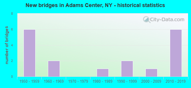
- New bridges - historical statistics
- 61950-1959
- 21960-1969
- 11980-1989
- 21990-1999
- 12000-2009
- 62010-2019


- Bridge Condition - Deck
- 12.5%Excellent
- 12.5%Very good
- 50.0%Good
- 12.5%Satisfactory
- 12.5%Fair

- Bridge Condition - Superstructure
- 12.5%Excellent
- 37.5%Very good
- 37.5%Good
- 12.5%Satisfactory

- Bridge Condition - Substructure
- 25.0%Excellent
- 25.0%Very good
- 12.5%Good
- 12.5%Satisfactory
- 25.0%Fair

- Bridge Condition - Channel
- 25.0%Good
- 50.0%Satisfactory
- 25.0%Poor

- Bridge Condition - Culverts
- 25.0%Very good
- 50.0%Good
- 25.0%Satisfactory
Find on map >> Show street view
Structure Number: 103209, Location: 2.0 MI N RTS I-81 + 178 (Lat: 43.840775, Lng: -76.025058), Route carried "on" structure: Other road , Year Built: 1959, Year Reconstructed: 2010, Status: Open, Structure Length: 3.72m (12.20ft), Average Daily Traffic: 287 (year 2017), Truck Traffic: 7%, Average Future Daily Traffic: 402 (year 2037), Design Load: HS 20, Features Intersected: RTE I81, Facility Carried by Structure: MICHAEL ROAD
Minimum Vertical Clearance: 30+ m (98+ ft), Kilometerpoint: 2.237, Lanes on structure: 2, Lanes under structure: 2, Owner: State Highway Agency, Approaching Roadway Width: 6.1m (20.0ft), Material/Design: Prestressed concrete, Design/Construction: Box Beam or Girders - Multiple, Number Of Spans In Main Unit: 1, Number Of Approach Spans: 2, Length of Maximum Span: 12.8m (42.0ft), Curb-To-Curb Width: 9.1m (29.9ft), Out-to-Out Width: 10.6m (34.8ft)
Condition: Deck: Good, Superstructure: Very good, Substructure: Satisfactory, Operating Rating: 66.2 metric tons, Method Used To Determine Operating Rating: Load Factor (LF), Inventory Rating: 39.0 metric tons, Method Used To Determine Inventory Rating: Load Factor (LF), Structural Evaluation: Equal to present minimum criteria, Deck Geometry: Equal to present minimum criteria, Underclear: High priority of corrective action, Approach Roadway Alignment: Equal to present desirable criteria, Length Of Structure Improvement: 3.71m (12.17ft), Designated Inspection Frequency: Every 24 months, Inspection Date: September 2020, Bridge Improvement Cost: $639,000, Roadway Improvement Cost: $374,000, Total Project Cost: $1,014,000 ( Estimate for 2021), Deck Structure Type: Concrete Cast-file-Place, Wearing Surface/Protective System: Wearing Surface: Bituminous, Membrane: Other
Find on map >> Show street view
Structure Number: 10321, Location: 4 MI S JCT I81 & SH 232 (Lat: 43.868797, Lng: -76.015378), Route carried "on" structure: State highway 177, Year Built: 2015, Status: Open, Structure Length: 8.53m (27.99ft), Average Daily Traffic: 2,445 (year 2015), Truck Traffic: 17%, Average Future Daily Traffic: 2,550 (year 2040), Design Load: HL 93, Features Intersected: RTE I81, RTE I81
Minimum Vertical Clearance: 30+ m (98+ ft), Kilometerpoint: 0.048, Lanes on structure: 2, Lanes under structure: 4, Base Highway Network: Yes, Owner: State Highway Agency, Approaching Roadway Width: 10.4m (34.1ft), Skew: 2 degrees, Material/Design: Steel continuous, Design/Construction: Stringer/Multi-beam, Number Of Spans In Main Unit: 2, Length of Maximum Span: 42.4m (139.1ft), Curb-To-Curb Width: 10.4m (34.1ft), Out-to-Out Width: 11.4m (37.4ft)
Condition: Deck: Excellent, Superstructure: Excellent, Substructure: Excellent, Operating Rating: 46.0 metric tons, Method Used To Determine Operating Rating: Load and Resistance Factor Rating (LRFR) rating reported by rating factor(RF) method using HL-93 loadings, Inventory Rating: 35.6 metric tons, Method Used To Determine Inventory Rating: Load and Resistance Factor Rating (LRFR) rating reported by rating factor(RF) method using HL-93 loadings, Structural Evaluation: Superior to present desirable criteria, Deck Geometry: Somewhat better than minimum adequacy, Underclear: High priority of corrective action, Approach Roadway Alignment: Equal to present desirable criteria, Length Of Structure Improvement: 8.53m (27.99ft), Designated Inspection Frequency: Every 24 months, Inspection Date: December 2021, Bridge Improvement Cost: $2,185,000, Roadway Improvement Cost: $1,279,000, Total Project Cost: $3,464,000 ( Estimate for 2021), Deck Structure Type: Concrete Cast-file-Place, Wearing Surface/Protective System: Wearing Surface: Integral Concrete, Deck Protection: Epoxy Coated Reinforcing
Find on map >> Show street view
Structure Number: 103211, Location: .2 MI SE EXIT 43 OF I81 (Lat: 43.885428, Lng: -75.995833), Route carried "on" structure: Ramp State highway 971, Year Built: 1959, Status: Open, Structure Length: 4.39m (14.40ft), Average Daily Traffic: 984 (year 2016), Truck Traffic: 13%, Average Future Daily Traffic: 1,378 (year 2036), Design Load: HS 20, Features Intersected: CSX TRANSPRTATION
Minimum Vertical Clearance: 30+ m (98+ ft), Kilometerpoint: 0.837, Lanes on structure: 2, Base Highway Network: Yes, Owner: State Highway Agency, Approaching Roadway Width: 12.5m (41.0ft), Material/Design: Steel, Design/Construction: Stringer/Multi-beam, Number Of Spans In Main Unit: 3, Length of Maximum Span: 16.1m (52.8ft), Curb or Sidewalk Widths: Left: 0.5m (1.6ft), Right: 0.5m (1.6ft), Curb-To-Curb Width: 9.1m (29.9ft), Out-to-Out Width: 10.8m (35.4ft)
Condition: Deck: Satisfactory, Superstructure: Good, Substructure: Good, Operating Rating: 59.6 metric tons, Method Used To Determine Operating Rating: Load and Resistance Factor Rating (LRFR) rating reported by rating factor(RF) method using HL-93 loadings, Inventory Rating: 46.0 metric tons, Method Used To Determine Inventory Rating: Load and Resistance Factor Rating (LRFR) rating reported by rating factor(RF) method using HL-93 loadings, Structural Evaluation: Better than present minimum criteria, Deck Geometry: Meets minimum limits, Underclear: Somewhat better than minimum adequacy, Approach Roadway Alignment: Equal to present desirable criteria, Length Of Structure Improvement: 4.38m (14.37ft), Designated Inspection Frequency: Every 24 months, Inspection Date: June 2020, Bridge Improvement Cost: $927,000, Roadway Improvement Cost: $543,000, Total Project Cost: $1,470,000 ( Estimate for 2021), Deck Structure Type: Concrete Cast-file-Place, Wearing Surface/Protective System: Wearing Surface: Integral Concrete
Find on map >> Show street view
Structure Number: 103212, Location: 2.3 MI S JCT RTS I81& 232 (Lat: 43.887228, Lng: -75.998953), Route carried "on" structure: Ramp State highway 971P, Year Built: 1998, Status: Open, Structure Length: 6.77m (22.21ft), Average Daily Traffic: 984 (year 2016), Truck Traffic: 13%, Average Future Daily Traffic: 1,378 (year 2036), Design Load: HS 25 or greater, Features Intersected: 81I 81I73051158 - NB, RT
Minimum Vertical Clearance: 30+ m (98+ ft), Kilometerpoint: 0.483, Lanes on structure: 2, Lanes under structure: 4, Base Highway Network: Yes, Owner: State Highway Agency, Approaching Roadway Width: 11.0m (36.1ft), Material/Design: Steel continuous, Design/Construction: Stringer/Multi-beam, Number Of Spans In Main Unit: 2, Length of Maximum Span: 33.5m (109.9ft), Curb-To-Curb Width: 10.7m (35.1ft), Out-to-Out Width: 11.6m (38.1ft)
Condition: Deck: Good, Superstructure: Good, Substructure: Very good, Operating Rating: 71.7 metric tons, Method Used To Determine Operating Rating: Load Factor (LF), Inventory Rating: 43.5 metric tons, Method Used To Determine Inventory Rating: Load Factor (LF), Structural Evaluation: Better than present minimum criteria, Deck Geometry: Better than present minimum criteria, Underclear: High priority of corrective action, Approach Roadway Alignment: Equal to present desirable criteria, Length Of Structure Improvement: 6.76m (22.18ft), Designated Inspection Frequency: Every 24 months, Inspection Date: September 2020, Bridge Improvement Cost: $1,635,000, Roadway Improvement Cost: $957,000, Total Project Cost: $2,592,000 ( Estimate for 2021), Deck Structure Type: Concrete Cast-file-Place, Wearing Surface/Protective System: Wearing Surface: Integral Concrete, Deck Protection: Epoxy Coated Reinforcing
Find on map >> Show street view
Structure Number: 1032141, Location: JCT I81 & SH 232 (Lat: 43.916764, Lng: -75.975867), Route carried "on" structure: Interstate 81, Year Built: 2014, Status: Open, Structure Length: 2.19m (7.19ft), Average Daily Traffic: 10,968 (year 2015), Truck Traffic: 21%, Design Load: HL 93, Features Intersected: RTE 232
Minimum Vertical Clearance: 30+ m (98+ ft), Kilometerpoint: 29.268, Lanes on structure: 3, Lanes under structure: 2, Base Highway Network: Yes, Owner: State Highway Agency, Approaching Roadway Width: 14.6m (47.9ft), Material/Design: Prestressed concrete, Design/Construction: Box Beam or Girders - Multiple, Number Of Spans In Main Unit: 1, Length of Maximum Span: 20.7m (67.9ft), Curb-To-Curb Width: 14.6m (47.9ft), Out-to-Out Width: 15.8m (51.8ft)
Condition: Deck: Very good, Superstructure: Very good, Substructure: Very good, Inventory Rating: 62.6 metric tons, Method Used To Determine Inventory Rating: Load Factor (LF), Structural Evaluation: Equal to present desirable criteria, Deck Geometry: Meets minimum limits, Underclear: Meets minimum limits, Approach Roadway Alignment: Equal to present desirable criteria, Length Of Structure Improvement: 2.19m (7.19ft), Designated Inspection Frequency: Every 24 months, Inspection Date: May 2020, Bridge Improvement Cost: $1,158,000, Roadway Improvement Cost: $678,000, Total Project Cost: $1,836,000 ( Estimate for 2021), Deck Structure Type: Concrete Cast-file-Place, Wearing Surface/Protective System: Wearing Surface: Integral Concrete, Deck Protection: Epoxy Coated Reinforcing
Find on map >> Show street view
Structure Number: 1032142, Location: JCT I-81 & SH 232 (Lat: 43.916708, Lng: -75.975642), Route carried "on" structure: Interstate 81, Year Built: 2013, Status: Open, Structure Length: 2.19m (7.19ft), Average Daily Traffic: 7,976 (year 2019), Truck Traffic: 19%, Average Future Daily Traffic: 10,408 (year 2040), Design Load: HL 93, Features Intersected: RTE 232
Minimum Vertical Clearance: 30+ m (98+ ft), Kilometerpoint: 29.268, Lanes on structure: 3, Lanes under structure: 2, Base Highway Network: Yes, Owner: State Highway Agency, Approaching Roadway Width: 14.6m (47.9ft), Material/Design: Prestressed concrete, Design/Construction: Box Beam or Girders - Single/Spread, Number Of Spans In Main Unit: 1, Length of Maximum Span: 20.7m (67.9ft), Curb-To-Curb Width: 14.6m (47.9ft), Out-to-Out Width: 15.8m (51.8ft)
Condition: Deck: Good, Superstructure: Satisfactory, Substructure: Excellent, Inventory Rating: 62.6 metric tons, Method Used To Determine Inventory Rating: Load Factor (LF), Structural Evaluation: Equal to present minimum criteria, Deck Geometry: Meets minimum limits, Underclear: Meets minimum limits, Approach Roadway Alignment: Equal to present desirable criteria, Length Of Structure Improvement: 2.19m (7.19ft), Designated Inspection Frequency: Every 24 months, Inspection Date: November 2021, Bridge Improvement Cost: $1,041,000, Roadway Improvement Cost: $610,000, Total Project Cost: $1,650,000 ( Estimate for 2021), Deck Structure Type: Concrete Cast-file-Place, Wearing Surface/Protective System: Wearing Surface: Integral Concrete, Deck Protection: Epoxy Coated Reinforcing
Find on map >> Show street view
Structure Number: 103215, Location: 0.1 MI N JCT I-81 + 232 (Lat: 43.917417, Lng: -75.975572), Route carried "on" structure: Interstate 81, Year Built: 1959, Status: Open, Structure Length: 0.73m (2.40ft), Average Daily Traffic: 15,952 (year 2019), Truck Traffic: 19%, Average Future Daily Traffic: 20,817 (year 2040), Design Load: HS 20, Features Intersected: MILL CREEK
Minimum Vertical Clearance: 30+ m (98+ ft), Kilometerpoint: 29.348, Lanes on structure: 5, Base Highway Network: Yes, Owner: State Highway Agency, Approaching Roadway Width: 21.9m (71.9ft), Skew: 31 degrees, Material/Design: Concrete, Design/Construction: Culvert, Number Of Spans In Main Unit: 2, Length of Maximum Span: 3.0m (9.8ft)
Condition: Channel: Good, Culverts: Good, Structural Evaluation: Better than present minimum criteria, Waterway Adequacy: Equal to present minimum criteria, Approach Roadway Alignment: Equal to present desirable criteria, Length Of Structure Improvement: 0.73m (2.40ft), Designated Inspection Frequency: Every 24 months, Inspection Date: August 2021, Bridge Improvement Cost: $717,000, Roadway Improvement Cost: $420,000, Total Project Cost: $1,138,000 ( Estimate for 2021)
Find on map >> Show street view
Structure Number: 106054, Location: .3 MI E JCT I81 & SH 232 (Lat: 43.915764, Lng: -75.970592), Route carried "on" structure: State highway 232, Year Built: 1969, Status: Open, Structure Length: 5.03m (16.50ft), Average Daily Traffic: 5,247 (year 2020), Truck Traffic: 6%, Average Future Daily Traffic: 6,374 (year 2040), Design Load: HS 20, Features Intersected: CSX TRANSPRTATION
Minimum Vertical Clearance: 30+ m (98+ ft), Kilometerpoint: 0.724, Lanes on structure: 2, Base Highway Network: Yes, Owner: State Highway Agency, Approaching Roadway Width: 14.6m (47.9ft), Skew: 1 degrees, Material/Design: Steel, Design/Construction: Stringer/Multi-beam, Number Of Spans In Main Unit: 3, Length of Maximum Span: 17.3m (56.8ft), Curb-To-Curb Width: 14.3m (46.9ft), Out-to-Out Width: 15.2m (49.9ft)
Condition: Deck: Fair, Superstructure: Good, Substructure: Fair, Operating Rating: 71.7 metric tons, Method Used To Determine Operating Rating: Load Factor (LF), Inventory Rating: 42.6 metric tons, Method Used To Determine Inventory Rating: Load Factor (LF), Structural Evaluation: Somewhat better than minimum adequacy, Deck Geometry: Superior to present desirable criteria, Underclear: Superior to present desirable criteria, Approach Roadway Alignment: Equal to present desirable criteria, Length Of Structure Improvement: 5.02m (16.47ft), Designated Inspection Frequency: Every 24 months, Inspection Date: June 2020, Bridge Improvement Cost: $1,480,000, Roadway Improvement Cost: $866,000, Total Project Cost: $2,346,000 ( Estimate for 2021), Deck Structure Type: Concrete Cast-file-Place, Wearing Surface/Protective System: Wearing Surface: Monolithic Concrete
Find on map >> Show street view
Structure Number: 106206, Location: 2.0 MI N JCT I-81 + 178 (Lat: 43.840503, Lng: -76.024289), Route carried "on" structure: Other road , Year Built: 1959, Year Reconstructed: 2010, Status: Open, Structure Length: 3.72m (12.20ft), Average Daily Traffic: 287 (year 2017), Truck Traffic: 7%, Average Future Daily Traffic: 402 (year 2037), Design Load: HS 20, Features Intersected: RTE I81, Facility Carried by Structure: MICHAEL ROAD
Minimum Vertical Clearance: 30+ m (98+ ft), Kilometerpoint: 2.317, Lanes on structure: 2, Lanes under structure: 2, Owner: State Highway Agency, Approaching Roadway Width: 7.0m (23.0ft), Material/Design: Prestressed concrete, Design/Construction: Box Beam or Girders - Multiple, Number Of Spans In Main Unit: 1, Number Of Approach Spans: 2, Length of Maximum Span: 12.8m (42.0ft), Curb-To-Curb Width: 9.1m (29.9ft), Out-to-Out Width: 10.6m (34.8ft)
Condition: Deck: Good, Superstructure: Very good, Substructure: Fair, Operating Rating: 66.2 metric tons, Method Used To Determine Operating Rating: Load Factor (LF), Inventory Rating: 39.0 metric tons, Method Used To Determine Inventory Rating: Load Factor (LF), Structural Evaluation: Somewhat better than minimum adequacy, Deck Geometry: Equal to present minimum criteria, Underclear: High priority of corrective action, Approach Roadway Alignment: Equal to present desirable criteria, Length Of Structure Improvement: 3.71m (12.17ft), Designated Inspection Frequency: Every 24 months, Inspection Date: September 2020, Bridge Improvement Cost: $639,000, Roadway Improvement Cost: $374,000, Total Project Cost: $1,014,000 ( Estimate for 2021), Deck Structure Type: Concrete Cast-file-Place, Wearing Surface/Protective System: Wearing Surface: Bituminous, Membrane: Other
Find on map >> Show street view
Structure Number: 107365, Location: 0.3 M E JCT I-81 & 232 (Lat: 43.915908, Lng: -75.968683), Route carried "on" structure: State highway 232, Year Built: 1969, Status: Open, Structure Length: 0.70m (2.30ft), Average Daily Traffic: 5,247 (year 2020), Truck Traffic: 6%, Average Future Daily Traffic: 6,374 (year 2040), Design Load: H 20, Features Intersected: MILL CREEK
Minimum Vertical Clearance: 30+ m (98+ ft), Kilometerpoint: 0.901, Lanes on structure: 2, Base Highway Network: Yes, Owner: State Highway Agency, Approaching Roadway Width: 14.3m (46.9ft), Skew: 1 degrees, Material/Design: Steel, Design/Construction: Culvert, Number Of Spans In Main Unit: 2, Length of Maximum Span: 2.7m (8.9ft)
Condition: Channel: Satisfactory, Culverts: Satisfactory, Operating Rating: 71.8 metric tons, Method Used To Determine Operating Rating: Field evaluation and documented engineering judgment, Inventory Rating: 29.4 metric tons, Method Used To Determine Inventory Rating: Field evaluation and documented engineering judgment, Structural Evaluation: Equal to present minimum criteria, Waterway Adequacy: Meets minimum limits, Approach Roadway Alignment: Equal to present desirable criteria, Length Of Structure Improvement: 0.70m (2.30ft), Designated Inspection Frequency: Every 24 months, Inspection Date: November 2021, Bridge Improvement Cost: $201,000, Roadway Improvement Cost: $118,000, Total Project Cost: $319,000 ( Estimate for 2021)
Find on map >> Show street view
Structure Number: 333865, Location: 3.0 MI NW OF ADAMS CENTER (Lat: 43.881589, Lng: -76.063933), Route carried "on" structure: County highway , Year Built: 1987, Status: Open, Structure Length: 1.16m (3.81ft), Average Daily Traffic: 1,458 (year 2019), Truck Traffic: 15%, Average Future Daily Traffic: 2,041 (year 2039), Features Intersected: STONY CREEK, Facility Carried by Structure: SOUTH HARBOR ROAD
Minimum Vertical Clearance: 30+ m (98+ ft), Kilometerpoint: 4.199, Lanes on structure: 2, Owner: County Highway Agency, Approaching Roadway Width: 6.7m (22.0ft), Material/Design: Steel, Design/Construction: Culvert, Number Of Spans In Main Unit: 2, Length of Maximum Span: 4.5m (14.8ft)
Condition: Channel: Satisfactory, Culverts: Good, Operating Rating: 75.8 metric tons, Method Used To Determine Operating Rating: Field evaluation and documented engineering judgment, Inventory Rating: 32.7 metric tons, Method Used To Determine Inventory Rating: Field evaluation and documented engineering judgment, Structural Evaluation: Better than present minimum criteria, Waterway Adequacy: Meets minimum limits, Approach Roadway Alignment: Equal to present minimum criteria, Length Of Structure Improvement: 1.15m (3.77ft), Designated Inspection Frequency: Every 24 months, Inspection Date: September 2020, Bridge Improvement Cost: $155,000, Roadway Improvement Cost: $91,000, Total Project Cost: $246,000 ( Estimate for 2021)
Find on map >> Show street view
Structure Number: 333955, Location: 5.7 MI N OF ADAMS CENTRE (Lat: 43.915450, Lng: -75.963147), Route carried "on" structure: Other road , Year Built: 2007, Status: Open, Structure Length: 0.70m (2.30ft), Average Daily Traffic: 366 (year 2019), Truck Traffic: 8%, Average Future Daily Traffic: 512 (year 2039), Features Intersected: MILL CREEK, Facility Carried by Structure: IVES STREET ROAD
Minimum Vertical Clearance: 30+ m (98+ ft), Kilometerpoint: 2.204, Lanes on structure: 2, Owner: Town or Township Highway Agency, Approaching Roadway Width: 6.1m (20.0ft), Material/Design: Concrete, Design/Construction: Culvert, Number Of Spans In Main Unit: 1, Length of Maximum Span: 6.1m (20.0ft), Curb-To-Curb Width: 6.6m (21.7ft), Out-to-Out Width: 10.4m (34.1ft)
Condition: Channel: Poor, Culverts: Very good, Operating Rating: 76.9 metric tons, Method Used To Determine Operating Rating: Field evaluation and documented engineering judgment, Inventory Rating: 40.8 metric tons, Method Used To Determine Inventory Rating: Field evaluation and documented engineering judgment, Structural Evaluation: Equal to present desirable criteria, Deck Geometry: Meets minimum limits, Waterway Adequacy: Somewhat better than minimum adequacy, Approach Roadway Alignment: Equal to present desirable criteria, Length Of Structure Improvement: 0.70m (2.30ft), Designated Inspection Frequency: Every 24 months, Inspection Date: April 2021, Bridge Improvement Cost: $247,000, Roadway Improvement Cost: $145,000, Total Project Cost: $392,000 ( Estimate for 2021)
Find on map >> Show street view
Structure Number: 103209, Location: 2.0 MI N RTS I-81 + 178 (Lat: 43.840775, Lng: -76.025058), Route carried "under" structure: Interstate 81, Year Built: 1959, Structure Length: 0. m, Average Daily Traffic: 19,510 (year 1970), Features Intersected: RTE I81, Facility Carried by Structure: MICHAEL ROAD
Minimum Vertical Clearance: 5.13m (16.83ft), Kilometerpoint: 19.710, Lanes on structure: 2, Lanes under structure: 2, Material/Design: Prestressed concrete, Design/Construction: Box Beam or Girders - Multiple, Length of Maximum Span: 12.8m (42.0ft)
Find on map >> Show street view
Structure Number: 10321, Location: 4 MI S JCT I81 & SH 232 (Lat: 43.868797, Lng: -76.015378), Route carried "under" structure: Interstate 81, Year Built: 2015, Structure Length: 0. m, Average Daily Traffic: 9,100 (year 1971), Features Intersected: RTE I81, RTE I81, Facility Carried by Structure: RTE 177
Minimum Vertical Clearance: 5.18m (16.99ft), Kilometerpoint: 22.848, Lanes on structure: 2, Lanes under structure: 2, Material/Design: Steel continuous, Design/Construction: Stringer/Multi-beam, Length of Maximum Span: 42.4m (139.1ft)
Find on map >> Show street view
Structure Number: 103212, Location: 2.3 MI S JCT RTS I81& 232 (Lat: 43.887228, Lng: -75.998953), Route carried "under" structure: Interstate 81, Year Built: 1998, Structure Length: 0. m, Average Daily Traffic: 15,662 (year 1995), Features Intersected: 81I 81I73051158 - NB, RT, Facility Carried by Structure: RTE 971P
Minimum Vertical Clearance: 5.33m (17.49ft), Kilometerpoint: 25.583, Lanes on structure: 2, Lanes under structure: 2, Material/Design: Steel continuous, Design/Construction: Stringer/Multi-beam, Length of Maximum Span: 33.5m (109.9ft)
Find on map >> Show street view
Structure Number: 1032141, Location: JCT I81 & SH 232 (Lat: 43.916764, Lng: -75.975867), Route carried "under" structure: State highway 232, Year Built: 2014, Structure Length: 0. m, Average Daily Traffic: 3,167 (year 1988), Features Intersected: RTE 232, Facility Carried by Structure: RTE I81
Minimum Vertical Clearance: 6.32m (20.73ft), Kilometerpoint: 4.023, Lanes on structure: 3, Lanes under structure: 2, Material/Design: Prestressed concrete, Design/Construction: Box Beam or Girders - Multiple, Length of Maximum Span: 20.7m (67.9ft)
Find on map >> Show street view
Structure Number: 1032142, Location: JCT I-81 & SH 232 (Lat: 43.916708, Lng: -75.975642), Route carried "under" structure: State highway 232, Year Built: 2013, Structure Length: 0. m, Average Daily Traffic: 3,167 (year 1988), Features Intersected: RTE 232, Facility Carried by Structure: RTE I81
Minimum Vertical Clearance: 4.80m (15.75ft), Kilometerpoint: 0.805, Lanes on structure: 3, Lanes under structure: 2, Material/Design: Prestressed concrete, Design/Construction: Box Beam or Girders - Single/Spread, Length of Maximum Span: 20.7m (67.9ft)
Find on map >> Show street view
Structure Number: 106206, Location: 2.0 MI N JCT I-81 + 178 (Lat: 43.840503, Lng: -76.024289), Route carried "under" structure: Interstate 81, Year Built: 1959, Structure Length: 0. m, Average Daily Traffic: 19,510 (year 1970), Features Intersected: RTE I81, Facility Carried by Structure: MICHAEL ROAD
Minimum Vertical Clearance: 5.23m (17.16ft), Kilometerpoint: 19.710, Lanes on structure: 2, Lanes under structure: 2, Material/Design: Prestressed concrete, Design/Construction: Box Beam or Girders - Multiple, Length of Maximum Span: 12.8m (42.0ft)