Bridge Statistics for Adamstown, Maryland (MD)
Condition, Traffic, Stress, Structural Evaluation, Project Costs
- National Bridge Inventory (NBI) Statistics
- 19Number of bridges
- 184ft / 56.0mTotal length
- 17,015Total average daily traffic
- 1,043Total average daily truck traffic
- 45,040Total future (year 2015) average daily traffic
- National Bridge Inventory (NBI) Registered Bridges for Adamstown
- No street view available for this location
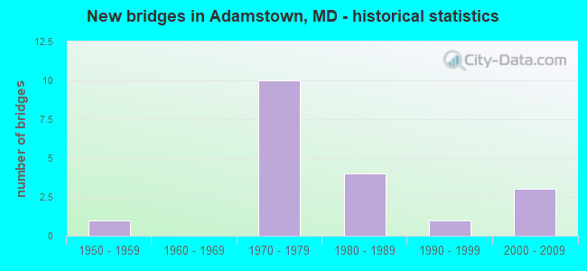
- New bridges - historical statistics
- 11950-1959
- 101970-1979
- 41980-1989
- 11990-1999
- 32000-2009

- Reconstructed bridges - Historical Statistics
- 21990-1999
- 22000-2009


- Bridge Condition - Deck
- 71.4%Good
- 28.6%Satisfactory

- Bridge Condition - Superstructure
- 42.9%Very good
- 28.6%Good
- 28.6%Satisfactory

- Bridge Condition - Substructure
- 28.6%Very good
- 14.3%Good
- 57.1%Satisfactory

- Bridge Condition - Channel
- 15.8%Very good
- 63.2%Good
- 10.5%Satisfactory
- 10.5%Fair

- Bridge Condition - Culverts
- 66.7%Good
- 16.7%Satisfactory
- 8.3%Fair
- 8.3%Poor
Find on map >> Show street view
Structure Number: 10000010001401, Location: 1.85 MILES WEST OF MD 85 (Lat: 39.268581, Lng: -77.490853), Route carried "on" structure: State highway 28, Year Built: 2007, Status: Open, Structure Length: 3.47m (11.38ft), Average Daily Traffic: 3,212 (year 2009), Truck Traffic: 11%, Average Future Daily Traffic: 3,452 (year 2029), Design Load: HS 25 or greater, Features Intersected: TUSCARORA CREEK
Minimum Vertical Clearance: 30+ m (98+ ft), Kilometerpoint: 4.634, Lanes on structure: 2, Base Highway Network: Yes, Owner: State Highway Agency, Approaching Roadway Width: 98.8m (324.1ft), Skew: 3 degrees, Material/Design: Prestressed concrete continuous, Design/Construction: Slab, Number Of Spans In Main Unit: 2, Length of Maximum Span: 16.8m (55.1ft), Curb or Sidewalk Widths: Left: 0.6m (2.0ft), Right: 0.6m (2.0ft), Curb-To-Curb Width: 9.8m (32.2ft), Out-to-Out Width: 11.0m (36.1ft)
Condition: Deck: Good, Superstructure: Good, Substructure: Good, Channel: Good, Operating Rating: 54.0 metric tons, Method Used To Determine Operating Rating: Load Factor (LF), Inventory Rating: 32.2 metric tons, Method Used To Determine Inventory Rating: Load Factor (LF), Structural Evaluation: Better than present minimum criteria, Deck Geometry: Meets minimum limits, Waterway Adequacy: Better than present minimum criteria, Approach Roadway Alignment: Equal to present desirable criteria, Designated Inspection Frequency: Every 24 months, Inspection Date: October 2021, Deck Structure Type: Concrete Cast-file-Place, Wearing Surface/Protective System: Wearing Surface: Integral Concrete, Deck Protection: Epoxy Coated Reinforcing
Find on map >> Show street view
Structure Number: 200000F-010102, Location: 0.19 MI NE OF ADAMSTOWN R (Lat: 39.313472, Lng: -77.476867), Route carried "on" structure: County highway 287, Year Built: 1989, Status: Open, Structure Length: 1.01m (3.31ft), Average Daily Traffic: 3,284 (year 2008), Truck Traffic: 5%, Average Future Daily Traffic: 3,940 (year 2032), Design Load: HS 20+Mod, Features Intersected: TUSCARORA CREEK, Facility Carried by Structure: MOUNTVILLE ROAD
Minimum Vertical Clearance: 30+ m (98+ ft), Kilometerpoint: 0.402, Lanes on structure: 2, Owner: County Highway Agency, Approaching Roadway Width: 8.5m (27.9ft), Material/Design: Concrete, Design/Construction: Culvert, Number Of Spans In Main Unit: 2, Length of Maximum Span: 4.9m (16.1ft), Curb-To-Curb Width: 8.6m (28.2ft), Out-to-Out Width: 9.3m (30.5ft)
Condition: Channel: Very good, Culverts: Good, Inventory Rating: 57.1 metric tons, Method Used To Determine Inventory Rating: Load Factor (LF), Structural Evaluation: Better than present minimum criteria, Deck Geometry: Meets minimum limits, Waterway Adequacy: Better than present minimum criteria, Approach Roadway Alignment: Equal to present desirable criteria, Designated Inspection Frequency: Every 24 months, Inspection Date: March 2020
Find on map >> Show street view
Structure Number: 200000F-010201, Location: SOUTH OF CAP STINE RD INT (Lat: 39.330222, Lng: -77.487889), Route carried "on" structure: County highway 294, Year Built: 2009, Status: Open, Structure Length: 0.82m (2.69ft), Average Daily Traffic: 1,797 (year 2009), Truck Traffic: 5%, Average Future Daily Traffic: 2,157 (year 2032), Design Load: HS 25 or greater, Features Intersected: BR OF TUSCARORA CREEK, Facility Carried by Structure: BALLENGER CREEK PI
Minimum Vertical Clearance: 30+ m (98+ ft), Kilometerpoint: 8.640, Lanes on structure: 2, Owner: County Highway Agency, Approaching Roadway Width: 7.0m (23.0ft), Skew: 3 degrees, Material/Design: Prestressed concrete, Design/Construction: Slab, Number Of Spans In Main Unit: 1, Length of Maximum Span: 7.9m (25.9ft), Curb or Sidewalk Widths: Left: 0.5m (1.6ft), Right: 0.5m (1.6ft), Curb-To-Curb Width: 9.8m (32.2ft), Out-to-Out Width: 10.6m (34.8ft)
Condition: Deck: Good, Superstructure: Very good, Substructure: Very good, Channel: Good, Operating Rating: 86.6 metric tons, Method Used To Determine Operating Rating: Load Factor (LF), Inventory Rating: 48.1 metric tons, Method Used To Determine Inventory Rating: Load Factor (LF), Structural Evaluation: Equal to present desirable criteria, Deck Geometry: Somewhat better than minimum adequacy, Waterway Adequacy: Better than present minimum criteria, Approach Roadway Alignment: Equal to present desirable criteria, Designated Inspection Frequency: Every 24 months, Inspection Date: March 2020, Wearing Surface/Protective System: Wearing Surface: Monolithic Concrete, Deck Protection: Epoxy Coated Reinforcing
Find on map >> Show street view
Structure Number: 200000F-010301, Location: 1.14 MI N OF MD RTE 28 (Lat: 39.286344, Lng: -77.488967), Route carried "on" structure: County highway 728, Year Built: 1982, Year Reconstructed: 1999, Status: Open, Structure Length: 0.73m (2.40ft), Average Daily Traffic: 191 (year 2009), Truck Traffic: 5%, Average Future Daily Traffic: 229 (year 2032), Features Intersected: TUSCARORA CREEK, Facility Carried by Structure: PLEASANT VIEW RD
Minimum Vertical Clearance: 30+ m (98+ ft), Kilometerpoint: 1.947, Lanes on structure: 2, Owner: County Highway Agency, Approaching Roadway Width: 3.7m (12.1ft), Material/Design: Steel, Design/Construction: Stringer/Multi-beam, Number Of Spans In Main Unit: 1, Length of Maximum Span: 6.4m (21.0ft), Curb-To-Curb Width: 6.1m (20.0ft), Out-to-Out Width: 6.1m (20.0ft)
Condition: Deck: Good, Superstructure: Very good, Substructure: Satisfactory, Channel: Good, Operating Rating: 67.6 metric tons, Method Used To Determine Operating Rating: Load Factor (LF), Inventory Rating: 40.8 metric tons, Method Used To Determine Inventory Rating: Load Factor (LF), Structural Evaluation: Equal to present minimum criteria, Deck Geometry: Meets minimum limits, Waterway Adequacy: High priority of corrective action, Approach Roadway Alignment: Equal to present minimum criteria, Designated Inspection Frequency: Every 24 months, Inspection Date: May 2020, Deck Structure Type: Wood or Timber, Wearing Surface/Protective System: Wearing Surface: Bituminous
Find on map >> Show street view
Structure Number: 200000F-010401, Location: 1 MI E OF MD RTE 85 (Lat: 39.293981, Lng: -77.438106), Route carried "on" structure: Alternate County highway 325, Year Built: 1977, Status: Open, Structure Length: 19.05m (62.50ft), Average Daily Traffic: 610 (year 2020), Truck Traffic: 5%, Average Future Daily Traffic: 910 (year 2040), Design Load: HS 20, Features Intersected: MONOCACY RIVER, Facility Carried by Structure: LILY PONS ROAD
Minimum Vertical Clearance: 30+ m (98+ ft), Kilometerpoint: 1.496, Lanes on structure: 2, Owner: County Highway Agency, Approaching Roadway Width: 12.2m (40.0ft), Material/Design: Steel continuous, Design/Construction: Stringer/Multi-beam, Number Of Spans In Main Unit: 5, Length of Maximum Span: 37.8m (124.0ft), Curb-To-Curb Width: 12.2m (40.0ft), Out-to-Out Width: 13.2m (43.3ft)
Condition: Deck: Satisfactory, Superstructure: Satisfactory, Substructure: Satisfactory, Channel: Good, Operating Rating: 73.5 metric tons, Method Used To Determine Operating Rating: Load Factor (LF), Inventory Rating: 43.5 metric tons, Method Used To Determine Inventory Rating: Load Factor (LF), Structural Evaluation: Equal to present minimum criteria, Deck Geometry: Equal to present desirable criteria, Waterway Adequacy: Superior to present desirable criteria, Approach Roadway Alignment: Equal to present desirable criteria, Designated Inspection Frequency: Every 24 months, Inspection Date: June 2020, Deck Structure Type: Concrete Cast-file-Place, Wearing Surface/Protective System: Wearing Surface: Monolithic Concrete
Find on map >> Show street view
Structure Number: 200000F-010501, Location: 1 MI N OF MD RTE 28 (Lat: 39.262564, Lng: -77.436297), Route carried "on" structure: County highway 332, Year Built: 1979, Status: Open, Structure Length: 19.45m (63.81ft), Average Daily Traffic: 515 (year 2018), Truck Traffic: 5%, Average Future Daily Traffic: 765 (year 2038), Design Load: HS 20, Features Intersected: MONOCACY RIVER, Facility Carried by Structure: PARK MILLS ROAD
Minimum Vertical Clearance: 30+ m (98+ ft), Kilometerpoint: 1.738, Lanes on structure: 2, Owner: County Highway Agency, Approaching Roadway Width: 12.2m (40.0ft), Material/Design: Steel continuous, Design/Construction: Stringer/Multi-beam, Number Of Spans In Main Unit: 3, Number Of Approach Spans: 1, Length of Maximum Span: 73.2m (240.2ft), Curb-To-Curb Width: 12.2m (40.0ft), Out-to-Out Width: 13.2m (43.3ft)
Condition: Deck: Good, Superstructure: Satisfactory, Substructure: Satisfactory, Channel: Good, Operating Rating: 66.2 metric tons, Method Used To Determine Operating Rating: Load Factor (LF), Inventory Rating: 39.5 metric tons, Method Used To Determine Inventory Rating: Load Factor (LF), Structural Evaluation: Equal to present minimum criteria, Deck Geometry: Equal to present desirable criteria, Waterway Adequacy: Superior to present desirable criteria, Approach Roadway Alignment: Equal to present minimum criteria, Designated Inspection Frequency: Every 24 months, Inspection Date: June 2020, Deck Structure Type: Concrete Cast-file-Place, Wearing Surface/Protective System: Wearing Surface: Integral Concrete
Find on map >> Show street view
Structure Number: 200000F-010603, Location: 0.53 MI S OF MD RTE 28 (Lat: 39.251761, Lng: -77.480417), Route carried "on" structure: County highway 1753, Year Built: 1982, Status: Open, Structure Length: 0.70m (2.30ft), Average Daily Traffic: 125 (year 2008), Truck Traffic: 5%, Average Future Daily Traffic: 150 (year 2032), Features Intersected: TUSCARORA CREEK, Facility Carried by Structure: NEW DESIGN ROAD
Minimum Vertical Clearance: 30+ m (98+ ft), Kilometerpoint: 0.885, Lanes on structure: 2, Owner: County Highway Agency, Approaching Roadway Width: 3.0m (9.8ft), Material/Design: Steel, Design/Construction: Culvert, Length of Maximum Span: 0.0m
Condition: Channel: Fair, Culverts: Good, Structural Evaluation: Better than present minimum criteria, Waterway Adequacy: Equal to present minimum criteria, Approach Roadway Alignment: Equal to present desirable criteria, Designated Inspection Frequency: Every 24 months, Inspection Date: April 2020
Find on map >> Show street view
Structure Number: 200000F-010701, Location: 1.23 MI W OF NEW DESIGN R (Lat: 39.302825, Lng: -77.485939), Route carried "on" structure: County highway 297, Year Built: 1950, Year Reconstructed: 1996, Status: Open, Structure Length: 0.82m (2.69ft), Average Daily Traffic: 525 (year 2008), Truck Traffic: 10%, Average Future Daily Traffic: 1,200 (year 2036), Design Load: HS 20, Features Intersected: TUSCARORA CREEK, Facility Carried by Structure: DOUBS ROAD
Minimum Vertical Clearance: 30+ m (98+ ft), Kilometerpoint: 1.947, Lanes on structure: 2, Owner: County Highway Agency, Approaching Roadway Width: 4.6m (15.1ft), Skew: 3 degrees, Material/Design: Steel, Design/Construction: Stringer/Multi-beam, Number Of Spans In Main Unit: 1, Length of Maximum Span: 7.3m (24.0ft), Curb-To-Curb Width: 5.9m (19.4ft), Out-to-Out Width: 6.0m (19.7ft)
Condition: Deck: Satisfactory, Superstructure: Good, Substructure: Satisfactory, Channel: Good, Operating Rating: 60.3 metric tons, Method Used To Determine Operating Rating: Load Factor (LF), Inventory Rating: 36.3 metric tons, Method Used To Determine Inventory Rating: Load Factor (LF), Structural Evaluation: Equal to present minimum criteria, Deck Geometry: High priority of replacement, Waterway Adequacy: Equal to present minimum criteria, Approach Roadway Alignment: Equal to present desirable criteria, Designated Inspection Frequency: Every 24 months, Inspection Date: May 2021, Deck Structure Type: Wood or Timber, Wearing Surface/Protective System: Wearing Surface: Bituminous
Find on map >> Show street view
Structure Number: 200000F-011003, Location: 0.53 MI E OF BALLENGER CR (Lat: 39.337444, Lng: -77.469744), Route carried "on" structure: County highway 308, Year Built: 1970, Status: Open, Structure Length: 1.01m (3.31ft), Average Daily Traffic: 965 (year 2009), Truck Traffic: 5%, Average Future Daily Traffic: 1,158 (year 2032), Features Intersected: TUSCARORA CREEK, Facility Carried by Structure: MANOR WOODS ROAD
Minimum Vertical Clearance: 30+ m (98+ ft), Kilometerpoint: 3.765, Lanes on structure: 2, Owner: County Highway Agency, Approaching Roadway Width: 6.1m (20.0ft), Skew: 4 degrees, Material/Design: Concrete, Design/Construction: Culvert, Length of Maximum Span: 0.0m
Condition: Channel: Fair, Culverts: Satisfactory, Structural Evaluation: Equal to present minimum criteria, Waterway Adequacy: Better than present minimum criteria, Approach Roadway Alignment: Equal to present desirable criteria, Designated Inspection Frequency: Every 24 months, Inspection Date: March 2020
Find on map >> Show street view
Structure Number: 200000F-011103, Location: 0.07 MI EAST OF MD RTE 85 (Lat: 39.295106, Lng: -77.444819), Route carried "on" structure: County highway 325, Year Built: 1977, Status: Open, Structure Length: 0.64m (2.10ft), Average Daily Traffic: 394 (year 2009), Truck Traffic: 5%, Average Future Daily Traffic: 473 (year 2032), Design Load: HS 20, Features Intersected: LOCUST RUN, Facility Carried by Structure: LILY PONS ROAD
Minimum Vertical Clearance: 30+ m (98+ ft), Kilometerpoint: 0.772, Lanes on structure: 2, Owner: County Highway Agency, Approaching Roadway Width: 12.2m (40.0ft), Material/Design: Steel, Design/Construction: Culvert, Length of Maximum Span: 0.0m
Condition: Channel: Very good, Culverts: Poor, Structural Evaluation: Meets minimum limits, Waterway Adequacy: Equal to present desirable criteria, Approach Roadway Alignment: Equal to present desirable criteria, Designated Inspection Frequency: Every 24 months, Inspection Date: April 2020
Find on map >> Show street view
Structure Number: 200000F-011203, Location: 0.1 MI EAST OF MD RTE 85 (Lat: 39.295008, Lng: -77.451744), Route carried "on" structure: County highway 325, Year Built: 1976, Status: Open, Structure Length: 0.88m (2.89ft), Average Daily Traffic: 394 (year 2009), Truck Traffic: 5%, Average Future Daily Traffic: 473 (year 2032), Design Load: HS 20, Features Intersected: SMALL STREAM, Facility Carried by Structure: LILY PONS ROAD
Minimum Vertical Clearance: 30+ m (98+ ft), Kilometerpoint: 0.161, Lanes on structure: 2, Owner: County Highway Agency, Approaching Roadway Width: 12.2m (40.0ft), Skew: 4 degrees, Material/Design: Steel, Design/Construction: Culvert, Length of Maximum Span: 0.0m
Condition: Channel: Good, Culverts: Fair, Operating Rating: 89.8 metric tons, Method Used To Determine Operating Rating: Load Factor (LF), Inventory Rating: 67.6 metric tons, Method Used To Determine Inventory Rating: Load Factor (LF), Structural Evaluation: Somewhat better than minimum adequacy, Waterway Adequacy: Equal to present desirable criteria, Approach Roadway Alignment: Equal to present desirable criteria, Designated Inspection Frequency: Every 24 months, Inspection Date: April 2020
Find on map >> Show street view
Structure Number: 200000F-011303, Location: 100' EAST OF BALLENGER CR (Lat: 39.307792, Lng: -77.491775), Route carried "on" structure: County highway 307, Year Built: 1986, Status: Open, Structure Length: 1.01m (3.31ft), Average Daily Traffic: 12 (year 2008), Truck Traffic: 1%, Average Future Daily Traffic: 15 (year 2032), Design Load: H 20, Features Intersected: DOUBS BRANCH, Facility Carried by Structure: FLAG POND ROAD
Minimum Vertical Clearance: 30+ m (98+ ft), Kilometerpoint: 0.000, Lanes on structure: 2, Owner: County Highway Agency, Approaching Roadway Width: 3.4m (11.2ft), Skew: 1 degrees, Material/Design: Steel, Design/Construction: Culvert, Length of Maximum Span: 0.0m
Condition: Channel: Good, Culverts: Good, Operating Rating: 73.5 metric tons, Method Used To Determine Operating Rating: Load Factor (LF), Inventory Rating: 44.0 metric tons, Method Used To Determine Inventory Rating: Load Factor (LF), Structural Evaluation: Better than present minimum criteria, Waterway Adequacy: Better than present minimum criteria, Approach Roadway Alignment: Equal to present desirable criteria, Designated Inspection Frequency: Every 24 months, Inspection Date: March 2020
Find on map >> Show street view
Structure Number: 200000F-011403, Location: 0.1 MI SW OF DOUBS ROAD (Lat: 39.308442, Lng: -77.492075), Route carried "on" structure: County highway 294, Year Built: 1975, Year Reconstructed: 2009, Status: Open, Structure Length: 0.61m (2.00ft), Average Daily Traffic: 1,065 (year 2009), Truck Traffic: 5%, Average Future Daily Traffic: 1,278 (year 2032), Design Load: H 20, Features Intersected: DOUBS BRANCH, Facility Carried by Structure: BALLENGER CREEK PI
Minimum Vertical Clearance: 30+ m (98+ ft), Kilometerpoint: 5.985, Lanes on structure: 2, Owner: County Highway Agency, Approaching Roadway Width: 8.2m (26.9ft), Skew: 3 degrees, Material/Design: Steel, Design/Construction: Culvert, Length of Maximum Span: 0.0m
Condition: Channel: Good, Culverts: Good, Operating Rating: 89.8 metric tons, Method Used To Determine Operating Rating: Load Factor (LF), Inventory Rating: 89.8 metric tons, Method Used To Determine Inventory Rating: Load Factor (LF), Structural Evaluation: Better than present minimum criteria, Waterway Adequacy: Better than present minimum criteria, Approach Roadway Alignment: Equal to present desirable criteria, Designated Inspection Frequency: Every 24 months, Inspection Date: March 2020
Find on map >> Show street view
Structure Number: 200000F-011503, Location: AT HOWARD STUP RD INTER (Lat: 39.336731, Lng: -77.495942), Route carried "on" structure: County highway 289, Year Built: 1975, Year Reconstructed: 2008, Status: Open, Structure Length: 0.64m (2.10ft), Average Daily Traffic: 183 (year 2009), Truck Traffic: 5%, Average Future Daily Traffic: 220 (year 2032), Design Load: H 20, Features Intersected: BR OF TUSCARORA CREEK, Facility Carried by Structure: CAP STINE ROAD
Minimum Vertical Clearance: 30+ m (98+ ft), Kilometerpoint: 0.531, Lanes on structure: 2, Owner: County Highway Agency, Approaching Roadway Width: 6.7m (22.0ft), Skew: 6 degrees, Material/Design: Steel, Design/Construction: Culvert, Length of Maximum Span: 0.0m
Condition: Channel: Good, Culverts: Good, Structural Evaluation: Better than present minimum criteria, Waterway Adequacy: Better than present minimum criteria, Approach Roadway Alignment: Equal to present desirable criteria, Designated Inspection Frequency: Every 24 months, Inspection Date: April 2020, Wearing Surface/Protective System: Wearing Surface: Bituminous
Find on map >> Show street view
Structure Number: 200000F-013203, Location: 0.1 MI E OF MOUNTVILLE RD (Lat: 39.338125, Lng: -77.503314), Route carried "on" structure: Business County highway 1977, Year Built: 1992, Status: Open, Structure Length: 0.76m (2.49ft), Average Daily Traffic: 350 (year 2009), Truck Traffic: 10%, Average Future Daily Traffic: 420 (year 2032), Design Load: HS 20, Features Intersected: TRIBUTARY OF TUSCARORA C, Facility Carried by Structure: WINCHESTER BOULEVA
Minimum Vertical Clearance: 30+ m (98+ ft), Kilometerpoint: 0.000, Lanes on structure: 2, Owner: County Highway Agency, Approaching Roadway Width: 12.5m (41.0ft), Skew: 1 degrees, Material/Design: Steel, Design/Construction: Culvert, Number Of Spans In Main Unit: 1, Length of Maximum Span: 7.6m (24.9ft)
Condition: Channel: Very good, Culverts: Good, Structural Evaluation: Better than present minimum criteria, Approach Roadway Alignment: Equal to present desirable criteria, Designated Inspection Frequency: Every 24 months, Inspection Date: May 2021
Find on map >> Show street view
Structure Number: 200000HO010801, Location: 0.3 MI S PINDELL SCHOOL (Lat: 39.305886, Lng: -77.505447), Route carried "on" structure: County highway 108, Year Built: 2003, Status: Open, Structure Length: 1.86m (6.10ft), Average Daily Traffic: 2,493 (year 1999), Truck Traffic: 4%, Average Future Daily Traffic: 27,300 (year 2015), Design Load: HS 25 or greater, Features Intersected: TRIB OF MIDDLE PATUXENT, Facility Carried by Structure: SANNER ROAD
Minimum Vertical Clearance: 2.99m (9.81ft), Kilometerpoint: 0.933, Lanes on structure: 2, Owner: County Highway Agency, Approaching Roadway Width: 12.8m (42.0ft), Material/Design: Prestressed concrete, Design/Construction: Stringer/Multi-beam, Number Of Spans In Main Unit: 1, Length of Maximum Span: 17.4m (57.1ft), Curb or Sidewalk Widths: Left: 0.0m, Right: 1.5m (4.9ft), Curb-To-Curb Width: 12.8m (42.0ft), Out-to-Out Width: 15.9m (52.2ft)
Condition: Deck: Good, Superstructure: Very good, Substructure: Very good, Channel: Good, Inventory Rating: 41.7 metric tons, Method Used To Determine Inventory Rating: Load Factor (LF), Structural Evaluation: Equal to present desirable criteria, Deck Geometry: Equal to present minimum criteria, Waterway Adequacy: Equal to present desirable criteria, Approach Roadway Alignment: Equal to present minimum criteria, Designated Inspection Frequency: Every 24 months, Inspection Date: March 2020, Deck Structure Type: Concrete Cast-file-Place, Wearing Surface/Protective System: Wearing Surface: Monolithic Concrete
Find on map >> Show street view
Structure Number: 200000HO026703, Location: 500' N of Owen Brown Rd (Lat: 39.337731, Lng: -77.471789), Route carried "on" structure: County highway , Year Built: 1972, Status: Open, Structure Length: 0.64m (2.10ft), Average Daily Traffic: 100 (year 2016), Truck Traffic: 2%, Average Future Daily Traffic: 100 (year 2037), Features Intersected: TRIB TO LITTLE PATUXENT, Facility Carried by Structure: SUNNY SPRING
Minimum Vertical Clearance: 30+ m (98+ ft), Kilometerpoint: 0.000, Lanes on structure: 2, Owner: County Highway Agency, Approaching Roadway Width: 9.8m (32.2ft), Skew: 1 degrees, Material/Design: Steel, Design/Construction: Culvert, Length of Maximum Span: 2.7m (8.9ft)
Condition: Channel: Good, Culverts: Good, Structural Evaluation: Better than present minimum criteria, Approach Roadway Alignment: Equal to present desirable criteria, Designated Inspection Frequency: Every 24 months, Inspection Date: Febuary 2020
Find on map >> Show street view
Structure Number: 200000HO026803, Location: At Quarterstaff Rd (Lat: 39.323039, Lng: -77.452392), Route carried "on" structure: County highway , Year Built: 1972, Status: Open, Structure Length: 0.79m (2.59ft), Average Daily Traffic: 500 (year 2016), Truck Traffic: 5%, Average Future Daily Traffic: 500 (year 2037), Features Intersected: TRIB TO LITTLE PATUXENT, Facility Carried by Structure: MARTIN ROAD
Minimum Vertical Clearance: 2.99m (9.81ft), Kilometerpoint: 0.000, Lanes on structure: 2, Owner: County Highway Agency, Approaching Roadway Width: 10.7m (35.1ft), Skew: 5 degrees, Material/Design: Steel, Design/Construction: Culvert, Length of Maximum Span: 2.4m (7.9ft)
Condition: Channel: Satisfactory, Culverts: Satisfactory, Structural Evaluation: Equal to present minimum criteria, Approach Roadway Alignment: Equal to present desirable criteria, Designated Inspection Frequency: Every 24 months, Inspection Date: Febuary 2020
Find on map >> Show street view
Structure Number: 200000HO026903, Location: 1000' NW of Martin Ln (Lat: 39.326411, Lng: -77.461297), Route carried "on" structure: County highway , Year Built: 1972, Status: Open, Structure Length: 1.07m (3.51ft), Average Daily Traffic: 300 (year 2016), Truck Traffic: 2%, Average Future Daily Traffic: 300 (year 2037), Features Intersected: TRIB TO LITTLE PATUXENT, Facility Carried by Structure: QUARTER STAFF ROAD
Minimum Vertical Clearance: 30+ m (98+ ft), Kilometerpoint: 0.000, Lanes on structure: 2, Owner: County Highway Agency, Approaching Roadway Width: 9.8m (32.2ft), Skew: 1 degrees, Material/Design: Steel, Design/Construction: Culvert, Length of Maximum Span: 2.4m (7.9ft)
Condition: Channel: Satisfactory, Culverts: Good, Structural Evaluation: Better than present minimum criteria, Approach Roadway Alignment: Equal to present desirable criteria, Designated Inspection Frequency: Every 24 months, Inspection Date: Febuary 2020