Bridge Statistics for Admire, Kansas (KS)
Condition, Traffic, Stress, Structural Evaluation, Project Costs
- National Bridge Inventory (NBI) Statistics
- 33Number of bridges
- 331ft / 101mTotal length
- $610,000Total costs
- 55,372Total average daily traffic
- 15,944Total average daily truck traffic
- National Bridge Inventory (NBI) Registered Bridges for Admire
- No street view available for this location
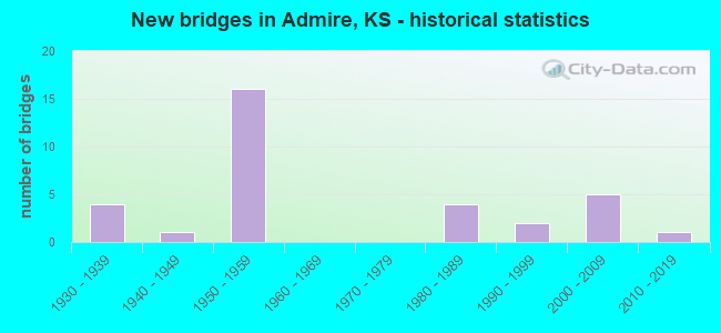
- New bridges - historical statistics
- 41930-1939
- 11940-1949
- 161950-1959
- 41980-1989
- 21990-1999
- 52000-2009
- 12010-2019

- Reconstructed bridges - Historical Statistics
- 21970-1979
- 41980-1989
- 01990-1999
- 02000-2009
- 02010-2019
- 12020-2022


- Bridge Condition - Deck
- 16.7%Very good
- 66.7%Good
- 12.5%Satisfactory
- 4.2%Fair

- Bridge Condition - Superstructure
- 16.7%Very good
- 70.8%Good
- 12.5%Satisfactory

- Bridge Condition - Substructure
- 16.7%Very good
- 79.2%Good
- 4.2%Satisfactory

- Bridge Condition - Channel
- 4.5%Very good
- 59.1%Good
- 36.4%Satisfactory

- Bridge Condition - Culverts
- 25.0%Good
- 75.0%Satisfactory
Find on map >> Show street view
Structure Number: 56069, Location: 4.0N 1.0E OF ADMIRE (Lat: 38.695333, Lng: -96.076444), Route carried "on" structure: County highway 1509, Year Built: 1959, Status: Open, Structure Length: 6.11m (20.05ft), Average Daily Traffic: 60 (year 2007), Average Future Daily Traffic: 95 (year 2039), Design Load: H 15, Features Intersected: ELM CREEK, Facility Carried by Structure: RD 370 (S-370)
Minimum Vertical Clearance: 30.47m (99.97ft), Kilometerpoint: 0.000, Lanes on structure: 2, Owner: County Highway Agency, Approaching Roadway Width: 5.7m (18.7ft), Material/Design: Steel continuous, Design/Construction: Stringer/Multi-beam, Number Of Spans In Main Unit: 3, Length of Maximum Span: 23.5m (77.1ft), Curb or Sidewalk Widths: Left: 0.4m (1.3ft), Right: 0.4m (1.3ft), Curb-To-Curb Width: 7.3m (24.0ft), Out-to-Out Width: 8.1m (26.6ft)
Condition: Deck: Satisfactory, Superstructure: Good, Substructure: Good, Channel: Good, Operating Rating: 29.6 metric tons, Method Used To Determine Operating Rating: Load Factor (LF), Inventory Rating: 17.7 metric tons, Method Used To Determine Inventory Rating: Load Factor (LF), Structural Evaluation: Somewhat better than minimum adequacy, Deck Geometry: Equal to present minimum criteria, Waterway Adequacy: Equal to present desirable criteria, Approach Roadway Alignment: Equal to present desirable criteria, Length Of Structure Improvement: 21.44m (70.34ft), Designated Inspection Frequency: Every 24 months, Inspection Date: Febuary 2021, Bridge Improvement Cost: $201,000, Roadway Improvement Cost: $70,000, Total Project Cost: $312,000, Deck Structure Type: Concrete Cast-file-Place
Find on map >> Show street view
Structure Number: 5609476049, Location: 2.0S 1.6E OF ALLEN (Lat: 38.622361, Lng: -96.141000), Route carried "on" structure: County highway , Year Built: 1994, Status: Open, Structure Length: 0.73m (2.40ft), Average Daily Traffic: 45 (year 2007), Average Future Daily Traffic: 50 (year 2039), Features Intersected: DUCK CREEK, Facility Carried by Structure: RD 320 947.6-490
Minimum Vertical Clearance: 30.47m (99.97ft), Kilometerpoint: 0.000, Lanes on structure: 2, Owner: County Highway Agency, Approaching Roadway Width: 5.7m (18.7ft), Material/Design: Steel, Design/Construction: Stringer/Multi-beam, Number Of Spans In Main Unit: 1, Length of Maximum Span: 7.0m (23.0ft), Curb-To-Curb Width: 7.1m (23.3ft), Out-to-Out Width: 7.3m (24.0ft)
Condition: Deck: Satisfactory, Superstructure: Satisfactory, Substructure: Good, Channel: Good, Operating Rating: 58.2 metric tons, Method Used To Determine Operating Rating: Load Factor (LF), Inventory Rating: 34.8 metric tons, Method Used To Determine Inventory Rating: Load Factor (LF), Structural Evaluation: Equal to present minimum criteria, Deck Geometry: Somewhat better than minimum adequacy, Waterway Adequacy: Somewhat better than minimum adequacy, Approach Roadway Alignment: Equal to present desirable criteria, Designated Inspection Frequency: Every 24 months, Inspection Date: Febuary 2021, Deck Structure Type: Corrugated Steel, Wearing Surface/Protective System: Wearing Surface: Bituminous
Find on map >> Show street view
Structure Number: 560949004907, Location: 2.7S 2.0E OF ALLEN (Lat: 38.612472, Lng: -96.132722), Route carried "on" structure: County highway , Year Built: 1994, Status: Open, Structure Length: 0.91m (2.99ft), Average Daily Traffic: 45 (year 2007), Average Future Daily Traffic: 50 (year 2039), Features Intersected: DUCK CREEK, Facility Carried by Structure: RD N 949.0-490.7
Minimum Vertical Clearance: 30.47m (99.97ft), Kilometerpoint: 0.000, Lanes on structure: 2, Owner: County Highway Agency, Approaching Roadway Width: 5.4m (17.7ft), Material/Design: Steel, Design/Construction: Stringer/Multi-beam, Number Of Spans In Main Unit: 1, Length of Maximum Span: 8.8m (28.9ft), Curb-To-Curb Width: 7.1m (23.3ft), Out-to-Out Width: 7.3m (24.0ft)
Condition: Deck: Good, Superstructure: Good, Substructure: Good, Channel: Satisfactory, Operating Rating: 51.1 metric tons, Method Used To Determine Operating Rating: Load Factor (LF), Inventory Rating: 30.6 metric tons, Method Used To Determine Inventory Rating: Load Factor (LF), Structural Evaluation: Better than present minimum criteria, Deck Geometry: Somewhat better than minimum adequacy, Waterway Adequacy: Somewhat better than minimum adequacy, Approach Roadway Alignment: Equal to present desirable criteria, Designated Inspection Frequency: Every 24 months, Inspection Date: Febuary 2021, Deck Structure Type: Corrugated Steel, Wearing Surface/Protective System: Wearing Surface: Bituminous
Find on map >> Show street view
Structure Number: 56094950492, Location: 2.0S 1.0W OF ADMIRE (Lat: 38.607833, Lng: -96.124806), Route carried "on" structure: County highway , Year Built: 1988, Status: Posted for load, Structure Length: 3.12m (10.24ft), Average Daily Traffic: 40 (year 2007), Average Future Daily Traffic: 40 (year 2039), Design Load: HS 20, Features Intersected: DUCK CREEK, Facility Carried by Structure: RD 310 (N.5-310)
Minimum Vertical Clearance: 30.47m (99.97ft), Kilometerpoint: 0.000, Lanes on structure: 2, Owner: County Highway Agency, Approaching Roadway Width: 5.4m (17.7ft), Material/Design: Concrete continuous, Design/Construction: Slab, Number Of Spans In Main Unit: 3, Length of Maximum Span: 12.2m (40.0ft), Curb or Sidewalk Widths: Left: 0.3m (1.0ft), Right: 0.3m (1.0ft), Curb-To-Curb Width: 7.3m (24.0ft), Out-to-Out Width: 7.9m (25.9ft)
Condition: Deck: Good, Superstructure: Good, Substructure: Very good, Channel: Good, Operating Rating: 31.8 metric tons, Method Used To Determine Operating Rating: Load Factor (LF), Inventory Rating: 19.1 metric tons, Method Used To Determine Inventory Rating: Load Factor (LF), Structural Evaluation: Somewhat better than minimum adequacy, Deck Geometry: Equal to present minimum criteria, Waterway Adequacy: Equal to present minimum criteria, Approach Roadway Alignment: Equal to present desirable criteria, Bridge Posting: Required (Relationship of Operating Rating to Maximum Legal Load: 20.0 - 29.9% below), Designated Inspection Frequency: Every 24 months, Inspection Date: Febuary 2021, Deck Structure Type: Concrete Cast-file-Place
Find on map >> Show street view
Structure Number: 560949904825, Location: 2.0N 0.5W OF ADMIRE (Lat: 38.673278, Lng: -96.117028), Route carried "on" structure: County highway , Year Built: 1934, Status: Posted for load, Structure Length: 0.88m (2.89ft), Average Daily Traffic: 20 (year 2007), Average Future Daily Traffic: 20 (year 2039), Design Load: HS 20, Features Intersected: STREAM, Facility Carried by Structure: N7 949.9-482.5
Minimum Vertical Clearance: 30.47m (99.97ft), Kilometerpoint: 0.000, Lanes on structure: 2, Owner: County Highway Agency, Approaching Roadway Width: 5.1m (16.7ft), Material/Design: Concrete, Design/Construction: Culvert, Number Of Spans In Main Unit: 3, Length of Maximum Span: 2.7m (8.9ft), Curb-To-Curb Width: 6.4m (21.0ft), Out-to-Out Width: 7.2m (23.6ft)
Condition: Channel: Satisfactory, Culverts: Satisfactory, Operating Rating: 40.0 metric tons, Method Used To Determine Operating Rating: Load Factor (LF), Inventory Rating: 25.0 metric tons, Method Used To Determine Inventory Rating: Load Factor (LF), Structural Evaluation: Equal to present minimum criteria, Deck Geometry: Somewhat better than minimum adequacy, Waterway Adequacy: Equal to present minimum criteria, Approach Roadway Alignment: Meets minimum limits, Designated Inspection Frequency: Every 24 months, Inspection Date: Febuary 2021
Find on map >> Show street view
Structure Number: 560951004828, Location: 2.0N 0.5W OF ADMIRE (Lat: 38.669694, Lng: -96.116139), Route carried "on" structure: County highway , Year Built: 1940, Status: Open, Structure Length: 1.41m (4.63ft), Average Daily Traffic: 20 (year 2007), Average Future Daily Traffic: 20 (year 2039), Design Load: HS 20, Features Intersected: 142 MILE CREEK, Facility Carried by Structure: RD. P 951.0-482.8
Minimum Vertical Clearance: 30.47m (99.97ft), Kilometerpoint: 0.000, Lanes on structure: 2, Owner: County Highway Agency, Approaching Roadway Width: 5.4m (17.7ft), Material/Design: Steel, Design/Construction: Stringer/Multi-beam, Number Of Spans In Main Unit: 1, Length of Maximum Span: 11.5m (37.7ft), Curb-To-Curb Width: 5.9m (19.4ft), Out-to-Out Width: 6.1m (20.0ft)
Condition: Deck: Good, Superstructure: Satisfactory, Substructure: Satisfactory, Channel: Satisfactory, Operating Rating: 20.0 metric tons, Method Used To Determine Operating Rating: Load Factor (LF), Inventory Rating: 12.0 metric tons, Method Used To Determine Inventory Rating: Load Factor (LF), Structural Evaluation: Meets minimum limits, Deck Geometry: Meets minimum limits, Waterway Adequacy: Meets minimum limits, Approach Roadway Alignment: Meets minimum limits, Length Of Structure Improvement: 7.46m (24.48ft), Designated Inspection Frequency: Every 24 months, Inspection Date: Febuary 2021, Bridge Improvement Cost: $48,000, Roadway Improvement Cost: $24,000, Total Project Cost: $84,000, Deck Structure Type: Corrugated Steel, Wearing Surface/Protective System: Wearing Surface: Bituminous
Find on map >> Show street view
Structure Number: 560951004922, Location: 2.0S 0.5W OF ADMIRE (Lat: 38.605444, Lng: -96.115972), Route carried "on" structure: County highway , Year Built: 2005, Status: Open, Structure Length: 1.23m (4.04ft), Average Daily Traffic: 20 (year 2007), Average Future Daily Traffic: 20 (year 2039), Design Load: HS 20, Features Intersected: DUCK CREEK, Facility Carried by Structure: LOCAL RD (P.0-308)
Minimum Vertical Clearance: 30.47m (99.97ft), Kilometerpoint: 0.000, Lanes on structure: 2, Owner: County Highway Agency, Approaching Roadway Width: 5.4m (17.7ft), Material/Design: Steel, Design/Construction: Stringer/Multi-beam, Number Of Spans In Main Unit: 1, Length of Maximum Span: 11.7m (38.4ft), Curb-To-Curb Width: 7.1m (23.3ft), Out-to-Out Width: 7.3m (24.0ft)
Condition: Deck: Good, Superstructure: Good, Substructure: Good, Channel: Satisfactory, Operating Rating: 51.7 metric tons, Method Used To Determine Operating Rating: Load Factor (LF), Inventory Rating: 30.9 metric tons, Method Used To Determine Inventory Rating: Load Factor (LF), Structural Evaluation: Better than present minimum criteria, Deck Geometry: Somewhat better than minimum adequacy, Waterway Adequacy: Better than present minimum criteria, Approach Roadway Alignment: Equal to present desirable criteria, Length Of Structure Improvement: 0.82m (2.69ft), Designated Inspection Frequency: Every 24 months, Inspection Date: Febuary 2021, Bridge Improvement Cost: $23,000, Roadway Improvement Cost: $2,000, Total Project Cost: $34,000, Deck Structure Type: Corrugated Steel, Wearing Surface/Protective System: Wearing Surface: Bituminous
Find on map >> Show street view
Structure Number: 56095110488, Location: 0.5W OF ADMIRE (Lat: 38.637000, Lng: -96.115306), Route carried "on" structure: County highway , Year Built: 1930, Status: Posted for load, Structure Length: 1.51m (4.95ft), Average Daily Traffic: 20 (year 2007), Average Future Daily Traffic: 20 (year 2039), Design Load: HS 20, Features Intersected: HILL CREEK, Facility Carried by Structure: RD 330 (N.1-7.0)
Minimum Vertical Clearance: 10.66m (34.97ft), Kilometerpoint: 0.000, Lanes on structure: 1, Owner: County Highway Agency, Approaching Roadway Width: 5.7m (18.7ft), Material/Design: Masonry, Design/Construction: Culvert, Number Of Spans In Main Unit: 1, Length of Maximum Span: 15.1m (49.5ft), Curb-To-Curb Width: 4.6m (15.1ft), Out-to-Out Width: 5.7m (18.7ft)
Condition: Channel: Satisfactory, Culverts: Satisfactory, Operating Rating: 19.9 metric tons, Method Used To Determine Operating Rating: Allowable Stress (AS), Inventory Rating: 19.9 metric tons, Method Used To Determine Inventory Rating: Allowable Stress (AS), Structural Evaluation: Somewhat better than minimum adequacy, Deck Geometry: Better than present minimum criteria, Waterway Adequacy: Equal to present minimum criteria, Approach Roadway Alignment: High priority of corrective action, Bridge Posting: Required (Relationship of Operating Rating to Maximum Legal Load: 30.0 - 39.9% below), Length Of Structure Improvement: 1.52m (4.99ft), Designated Inspection Frequency: Every 24 months, Inspection Date: Febuary 2021, Bridge Improvement Cost: $58,000, Roadway Improvement Cost: $5,000, Total Project Cost: $69,000, Deck Structure Type: Other, Wearing Surface/Protective System: Wearing Surface: Gravel
Find on map >> Show street view
Structure Number: 560955004948, Location: 4.0S 1.0E OF ADMIRE (Lat: 38.582472, Lng: -96.079083), Route carried "on" structure: County highway , Year Built: 2006, Status: Open, Structure Length: 1.23m (4.04ft), Average Daily Traffic: 40 (year 2007), Average Future Daily Traffic: 40 (year 2039), Design Load: HS 20, Features Intersected: DUCK CREEK, Facility Carried by Structure: RD. S 955-494.8
Minimum Vertical Clearance: 30.47m (99.97ft), Kilometerpoint: 0.000, Lanes on structure: 2, Owner: County Highway Agency, Approaching Roadway Width: 4.8m (15.7ft), Material/Design: Steel, Design/Construction: Stringer/Multi-beam, Number Of Spans In Main Unit: 1, Length of Maximum Span: 11.7m (38.4ft), Curb-To-Curb Width: 7.1m (23.3ft), Out-to-Out Width: 7.3m (24.0ft)
Condition: Deck: Good, Superstructure: Good, Substructure: Good, Channel: Good, Operating Rating: 51.7 metric tons, Method Used To Determine Operating Rating: Load Factor (LF), Inventory Rating: 30.9 metric tons, Method Used To Determine Inventory Rating: Load Factor (LF), Structural Evaluation: Better than present minimum criteria, Deck Geometry: Somewhat better than minimum adequacy, Waterway Adequacy: Somewhat better than minimum adequacy, Approach Roadway Alignment: Better than present minimum criteria, Length Of Structure Improvement: 1.13m (3.71ft), Designated Inspection Frequency: Every 24 months, Inspection Date: Febuary 2021, Bridge Improvement Cost: $36,000, Roadway Improvement Cost: $4,000, Total Project Cost: $53,000, Deck Structure Type: Corrugated Steel, Wearing Surface/Protective System: Wearing Surface: Bituminous
Find on map >> Show street view
Structure Number: 56095550492, Location: 2.0S 1.5E OF ADMIRE (Lat: 38.608306, Lng: -96.068694), Route carried "on" structure: County highway , Year Built: 1988, Status: Open, Structure Length: 3.12m (10.24ft), Average Daily Traffic: 30 (year 2007), Average Future Daily Traffic: 30 (year 2039), Design Load: H 20, Features Intersected: HILL CREEK, Facility Carried by Structure: RD. 310 (S.5-310)
Minimum Vertical Clearance: 30.47m (99.97ft), Kilometerpoint: 0.000, Lanes on structure: 2, Owner: County Highway Agency, Approaching Roadway Width: 5.4m (17.7ft), Material/Design: Concrete continuous, Design/Construction: Slab, Number Of Spans In Main Unit: 3, Length of Maximum Span: 12.2m (40.0ft), Curb or Sidewalk Widths: Left: 0.3m (1.0ft), Right: 0.3m (1.0ft), Curb-To-Curb Width: 7.3m (24.0ft), Out-to-Out Width: 7.9m (25.9ft)
Condition: Deck: Good, Superstructure: Good, Substructure: Good, Channel: Satisfactory, Operating Rating: 66.5 metric tons, Method Used To Determine Operating Rating: Load Factor (LF), Inventory Rating: 39.8 metric tons, Method Used To Determine Inventory Rating: Load Factor (LF), Structural Evaluation: Better than present minimum criteria, Deck Geometry: Equal to present minimum criteria, Waterway Adequacy: Equal to present minimum criteria, Approach Roadway Alignment: Somewhat better than minimum adequacy, Designated Inspection Frequency: Every 24 months, Inspection Date: Febuary 2021, Deck Structure Type: Concrete Cast-file-Place
Find on map >> Show street view
Structure Number: 56095570488, Location: 2.0E of Admire (Lat: 38.637139, Lng: -96.066361), Route carried "on" structure: County highway , Year Built: 2012, Status: Open, Structure Length: 4.71m (15.45ft), Average Daily Traffic: 10 (year 2012), Truck Traffic: 10%, Average Future Daily Traffic: 25 (year 2039), Design Load: HL 93, Features Intersected: 142 Mile Creek, Facility Carried by Structure: RD 330 955.7-488.0
Minimum Vertical Clearance: 30.47m (99.97ft), Kilometerpoint: 0.000, Lanes on structure: 2, Owner: County Highway Agency, Approaching Roadway Width: 5.4m (17.7ft), Material/Design: Concrete continuous, Design/Construction: Slab, Number Of Spans In Main Unit: 3, Length of Maximum Span: 21.9m (71.9ft), Curb or Sidewalk Widths: Left: 0.3m (1.0ft), Right: 0.3m (1.0ft), Curb-To-Curb Width: 9.1m (29.9ft), Out-to-Out Width: 9.8m (32.2ft)
Condition: Deck: Very good, Superstructure: Very good, Substructure: Very good, Channel: Good, Operating Rating: 48.9 metric tons, Method Used To Determine Operating Rating: Load and Resistance Factor Rating (LRFR) rating reported by rating factor(RF) method using HL-93 loadings, Inventory Rating: 37.6 metric tons, Method Used To Determine Inventory Rating: Load and Resistance Factor Rating (LRFR) rating reported by rating factor(RF) method using HL-93 loadings, Structural Evaluation: Equal to present desirable criteria, Deck Geometry: Better than present minimum criteria, Waterway Adequacy: Better than present minimum criteria, Approach Roadway Alignment: Equal to present desirable criteria, Designated Inspection Frequency: Every 24 months, Inspection Date: Febuary 2021, Deck Structure Type: Concrete Cast-file-Place
Find on map >> Show street view
Structure Number: 56095700488, Location: 2.0E OF ADMIRE (Lat: 38.637111, Lng: -96.059222), Route carried "on" structure: County highway , Year Built: 2004, Status: Open, Structure Length: 1.22m (4.00ft), Average Daily Traffic: 10 (year 2007), Average Future Daily Traffic: 10 (year 2039), Design Load: HS 20, Features Intersected: STREAM, Facility Carried by Structure: RD. 330 (Q.0-7.0)
Minimum Vertical Clearance: 30.47m (99.97ft), Kilometerpoint: 0.000, Lanes on structure: 2, Owner: County Highway Agency, Approaching Roadway Width: 5.4m (17.7ft), Material/Design: Steel, Design/Construction: Stringer/Multi-beam, Number Of Spans In Main Unit: 1, Length of Maximum Span: 11.7m (38.4ft), Curb-To-Curb Width: 7.0m (23.0ft), Out-to-Out Width: 7.2m (23.6ft)
Condition: Deck: Good, Superstructure: Satisfactory, Substructure: Good, Channel: Good, Operating Rating: 47.1 metric tons, Method Used To Determine Operating Rating: Load Factor (LF), Inventory Rating: 28.2 metric tons, Method Used To Determine Inventory Rating: Load Factor (LF), Structural Evaluation: Equal to present minimum criteria, Deck Geometry: Somewhat better than minimum adequacy, Waterway Adequacy: Better than present minimum criteria, Approach Roadway Alignment: Equal to present desirable criteria, Length Of Structure Improvement: 1.25m (4.10ft), Designated Inspection Frequency: Every 24 months, Inspection Date: Febuary 2021, Bridge Improvement Cost: $38,000, Roadway Improvement Cost: $4,000, Total Project Cost: $58,000, Deck Structure Type: Corrugated Steel, Wearing Surface/Protective System: Wearing Surface: Bituminous
Find on map >> Show street view
Structure Number: 999905600560321, Location: 0.67 MI E K99 (Lat: 38.651667, Lng: -96.085000), Route carried "on" structure: US 56, Year Built: 1931, Status: Open, Structure Length: 0.77m (2.53ft), Average Daily Traffic: 895 (year 2020), Truck Traffic: 21%, Average Future Daily Traffic: 1,050 (year 2041), Design Load: H 15, Features Intersected: 142 MILE CREEK DRAINAGE
Minimum Vertical Clearance: 30.47m (99.97ft), Kilometerpoint: 23.702, Lanes on structure: 2, Base Highway Network: Yes, Owner: State Highway Agency, Approaching Roadway Width: 7.3m (24.0ft), Material/Design: Concrete, Design/Construction: Culvert, Number Of Spans In Main Unit: 3, Length of Maximum Span: 2.4m (7.9ft), Curb-To-Curb Width: 9.1m (29.9ft), Out-to-Out Width: 9.9m (32.5ft)
Condition: Channel: Satisfactory, Culverts: Satisfactory, Operating Rating: 41.9 metric tons, Method Used To Determine Operating Rating: Load Factor (LF), Inventory Rating: 25.1 metric tons, Method Used To Determine Inventory Rating: Load Factor (LF), Structural Evaluation: Equal to present minimum criteria, Deck Geometry: Equal to present minimum criteria, Waterway Adequacy: Better than present minimum criteria, Approach Roadway Alignment: Meets minimum limits, Length Of Structure Improvement: 2.54m (8.33ft), Designated Inspection Frequency: Every 24 months, Inspection Date: June 2021, Deck Structure Type: Concrete Cast-file-Place, Wearing Surface/Protective System: Wearing Surface: Bituminous
Find on map >> Show street view
Structure Number: 999905600561531, Location: .11 MI E K-99 HIGHWAY (Lat: 38.651944, Lng: -96.095278), Route carried "on" structure: US 56, Year Built: 2002, Status: Open, Structure Length: 5.58m (18.31ft), Average Daily Traffic: 895 (year 2020), Truck Traffic: 21%, Average Future Daily Traffic: 1,050 (year 2041), Design Load: HS 25 or greater, Features Intersected: 142 MILE CREEK
Minimum Vertical Clearance: 30.47m (99.97ft), Kilometerpoint: 22.829, Lanes on structure: 2, Base Highway Network: Yes, Owner: State Highway Agency, Approaching Roadway Width: 13.4m (44.0ft), Material/Design: Concrete continuous, Design/Construction: Slab, Number Of Spans In Main Unit: 3, Length of Maximum Span: 22.0m (72.2ft), Curb-To-Curb Width: 13.4m (44.0ft), Out-to-Out Width: 14.0m (45.9ft)
Condition: Deck: Very good, Superstructure: Very good, Substructure: Good, Channel: Good, Operating Rating: 90.6 metric tons, Method Used To Determine Operating Rating: Load Factor (LF), Inventory Rating: 52.6 metric tons, Method Used To Determine Inventory Rating: Load Factor (LF), Structural Evaluation: Better than present minimum criteria, Deck Geometry: Superior to present desirable criteria, Waterway Adequacy: Equal to present desirable criteria, Approach Roadway Alignment: Meets minimum limits, Length Of Structure Improvement: 18.29m (60.01ft), Designated Inspection Frequency: Every 24 months, Inspection Date: June 2021, Wearing Surface/Protective System: Wearing Surface: Monolithic Concrete, Deck Protection: Epoxy Coated Reinforcing
Find on map >> Show street view
Structure Number: 999909900561331, Location: 1.80 MI N OF KTA N JCT (Lat: 38.598056, Lng: -96.097500), Route carried "on" structure: State highway 99, Year Built: 1981, Status: Open, Structure Length: 3.12m (10.24ft), Average Daily Traffic: 700 (year 2020), Truck Traffic: 23%, Average Future Daily Traffic: 837 (year 2041), Design Load: HS 20, Features Intersected: DUCK CREEK
Minimum Vertical Clearance: 30.47m (99.97ft), Kilometerpoint: 55.310, Lanes on structure: 2, Base Highway Network: Yes, Owner: State Highway Agency, Approaching Roadway Width: 7.3m (24.0ft), Material/Design: Concrete continuous, Design/Construction: Slab, Number Of Spans In Main Unit: 3, Length of Maximum Span: 12.2m (40.0ft), Curb-To-Curb Width: 11.0m (36.1ft), Out-to-Out Width: 11.6m (38.1ft)
Condition: Deck: Good, Superstructure: Good, Substructure: Good, Channel: Good, Operating Rating: 54.4 metric tons, Method Used To Determine Operating Rating: Load Factor (LF), Inventory Rating: 32.7 metric tons, Method Used To Determine Inventory Rating: Load Factor (LF), Structural Evaluation: Better than present minimum criteria, Deck Geometry: Better than present minimum criteria, Waterway Adequacy: Better than present minimum criteria, Approach Roadway Alignment: Somewhat better than minimum adequacy, Length Of Structure Improvement: 10.25m (33.63ft), Designated Inspection Frequency: Every 24 months, Inspection Date: April 2020, Deck Structure Type: Concrete Cast-file-Place, Wearing Surface/Protective System: Wearing Surface: Low Slump Concrete
Find on map >> Show street view
Structure Number: 999909900561341, Location: 3.70 MI N OF KTA N JCT (Lat: 38.625278, Lng: -96.097500), Route carried "on" structure: State highway 99, Year Built: 1981, Status: Open, Structure Length: 4.34m (14.24ft), Average Daily Traffic: 700 (year 2020), Truck Traffic: 23%, Average Future Daily Traffic: 837 (year 2041), Design Load: HS 20, Features Intersected: HILL CREEK
Minimum Vertical Clearance: 30.47m (99.97ft), Kilometerpoint: 58.348, Lanes on structure: 2, Base Highway Network: Yes, Owner: State Highway Agency, Approaching Roadway Width: 7.3m (24.0ft), Material/Design: Concrete continuous, Design/Construction: Slab, Number Of Spans In Main Unit: 3, Length of Maximum Span: 17.1m (56.1ft), Curb-To-Curb Width: 11.0m (36.1ft), Out-to-Out Width: 11.6m (38.1ft)
Condition: Deck: Good, Superstructure: Good, Substructure: Very good, Channel: Satisfactory, Operating Rating: 56.2 metric tons, Method Used To Determine Operating Rating: Load Factor (LF), Inventory Rating: 33.6 metric tons, Method Used To Determine Inventory Rating: Load Factor (LF), Structural Evaluation: Better than present minimum criteria, Deck Geometry: Better than present minimum criteria, Waterway Adequacy: Equal to present minimum criteria, Approach Roadway Alignment: Somewhat better than minimum adequacy, Length Of Structure Improvement: 14.25m (46.75ft), Designated Inspection Frequency: Every 24 months, Inspection Date: April 2020, Deck Structure Type: Concrete Cast-file-Place, Wearing Surface/Protective System: Wearing Surface: Low Slump Concrete
Find on map >> Show street view
Structure Number: 999909900561541, Location: 0.13 MI N US-56 HWY (Lat: 38.653889, Lng: -96.097500), Route carried "on" structure: State highway 99, Year Built: 2001, Year Reconstructed: 2020, Status: Open, Structure Length: 5.69m (18.67ft), Average Daily Traffic: 570 (year 2020), Truck Traffic: 15%, Average Future Daily Traffic: 682 (year 2041), Design Load: HL 93, Features Intersected: 142 MILE CREEK
Minimum Vertical Clearance: 30.47m (99.97ft), Kilometerpoint: 61.491, Lanes on structure: 2, Base Highway Network: Yes, Owner: State Highway Agency, Approaching Roadway Width: 11.0m (36.1ft), Material/Design: Prestressed concrete continuous, Design/Construction: Slab, Number Of Spans In Main Unit: 3, Length of Maximum Span: 22.0m (72.2ft), Curb-To-Curb Width: 11.0m (36.1ft), Out-to-Out Width: 11.6m (38.1ft)
Condition: Deck: Very good, Superstructure: Very good, Substructure: Very good, Channel: Good, Operating Rating: 68.4 metric tons, Method Used To Determine Operating Rating: Load and Resistance Factor Rating (LRFR) rating reported by rating factor(RF) method using HL-93 loadings, Inventory Rating: 44.4 metric tons, Method Used To Determine Inventory Rating: Load and Resistance Factor Rating (LRFR) rating reported by rating factor(RF) method using HL-93 loadings, Structural Evaluation: Equal to present desirable criteria, Deck Geometry: Better than present minimum criteria, Waterway Adequacy: Somewhat better than minimum adequacy, Approach Roadway Alignment: Somewhat better than minimum adequacy, Length Of Structure Improvement: 18.67m (61.25ft), Designated Inspection Frequency: Every 24 months, Inspection Date: June 2021, Deck Structure Type: Concrete Precast Panels, Wearing Surface/Protective System: Wearing Surface: Epoxy Overlay, Deck Protection: Epoxy Coated Reinforcing
Find on map >> Show street view
Structure Number: 999933500560953, Location: 1.73 MI NE N JCT K-99 (Lat: 38.592222, Lng: -96.077222), Route carried "on" structure: ServiceCounty highway 592, Year Built: 1956, Status: Open, Structure Length: 5.06m (16.60ft), Average Daily Traffic: 21 (year 2020), Average Future Daily Traffic: 6,837 (year 2041), Features Intersected: I-335 HWY (KTA), Facility Carried by Structure: LOCAL ROAD
Minimum Vertical Clearance: 30.47m (99.97ft), Kilometerpoint: 5.032, Lanes on structure: 2, Lanes under structure: 4, Owner: State Toll Authority, Approaching Roadway Width: 6.1m (20.0ft), Material/Design: Steel continuous, Design/Construction: Girder and Floorbeam System, Number Of Spans In Main Unit: 4, Length of Maximum Span: 14.6m (47.9ft), Curb-To-Curb Width: 6.1m (20.0ft), Out-to-Out Width: 7.7m (25.3ft)
Condition: Deck: Good, Superstructure: Good, Substructure: Good, Operating Rating: 29.3 metric tons, Method Used To Determine Operating Rating: Load Factor (LF), Inventory Rating: 17.6 metric tons, Method Used To Determine Inventory Rating: Load Factor (LF), Structural Evaluation: Somewhat better than minimum adequacy, Deck Geometry: Somewhat better than minimum adequacy, Underclear: High priority of corrective action, Approach Roadway Alignment: High priority of corrective action, Length Of Structure Improvement: 16.60m (54.46ft), Designated Inspection Frequency: Every 24 months, Critical Feature Inspection Frequency: Every 24 months, Inspection Date: October 2021, Critical Feature Inspection Date: October 2021, Deck Structure Type: Concrete Cast-file-Place, Wearing Surface/Protective System: Wearing Surface: Monolithic Concrete
Find on map >> Show street view
Structure Number: 999933500560963, Location: 2.85 MI NE N JCT K-99 (Lat: 38.604444, Lng: -96.064167), Route carried "on" structure: Interstate 335, Year Built: 1956, Year Reconstructed: 1978, Status: Open, Structure Length: 4.85m (15.91ft), Average Daily Traffic: 4,153 (year 2020), Truck Traffic: 31%, Average Future Daily Traffic: 5,934 (year 2041), Design Load: HS 20+Mod, Features Intersected: HILL CREEK
Minimum Vertical Clearance: 30.47m (99.97ft), Kilometerpoint: 26.709, Lanes on structure: 2, Base Highway Network: Yes, Toll: On Interstate toll segment, Owner: State Toll Authority, Approaching Roadway Width: 11.0m (36.1ft), Material/Design: Steel continuous, Design/Construction: Stringer/Multi-beam, Number Of Spans In Main Unit: 3, Length of Maximum Span: 18.6m (61.0ft), Curb-To-Curb Width: 9.8m (32.2ft), Out-to-Out Width: 10.5m (34.4ft)
Condition: Deck: Fair, Superstructure: Good, Substructure: Good, Channel: Good, Operating Rating: 62.7 metric tons, Method Used To Determine Operating Rating: Load Factor (LF), Inventory Rating: 37.6 metric tons, Method Used To Determine Inventory Rating: Load Factor (LF), Structural Evaluation: Better than present minimum criteria, Deck Geometry: High priority of replacement, Waterway Adequacy: Equal to present desirable criteria, Approach Roadway Alignment: Equal to present minimum criteria, Length Of Structure Improvement: 15.90m (52.17ft), Designated Inspection Frequency: Every 24 months, Inspection Date: June 2020, Deck Structure Type: Concrete Cast-file-Place, Wearing Surface/Protective System: Wearing Surface: Epoxy Overlay
Find on map >> Show street view
Structure Number: 999933500560973, Location: 2.84 MI NE N JCT K-99 (Lat: 38.604444, Lng: -96.064167), Route carried "on" structure: Interstate 335, Year Built: 1956, Year Reconstructed: 1978, Status: Open, Structure Length: 4.85m (15.91ft), Average Daily Traffic: 4,153 (year 2020), Truck Traffic: 31%, Average Future Daily Traffic: 5,934 (year 2041), Design Load: HS 20+Mod, Features Intersected: HILL CREEK
Minimum Vertical Clearance: 30.47m (99.97ft), Kilometerpoint: 26.390, Lanes on structure: 2, Base Highway Network: Yes, Toll: On Interstate toll segment, Owner: State Toll Authority, Approaching Roadway Width: 11.0m (36.1ft), Material/Design: Steel continuous, Design/Construction: Stringer/Multi-beam, Number Of Spans In Main Unit: 3, Length of Maximum Span: 18.6m (61.0ft), Curb-To-Curb Width: 9.8m (32.2ft), Out-to-Out Width: 10.5m (34.4ft)
Condition: Deck: Very good, Superstructure: Good, Substructure: Good, Channel: Very good, Operating Rating: 62.7 metric tons, Method Used To Determine Operating Rating: Load Factor (LF), Inventory Rating: 37.6 metric tons, Method Used To Determine Inventory Rating: Load Factor (LF), Structural Evaluation: Better than present minimum criteria, Deck Geometry: High priority of replacement, Waterway Adequacy: Equal to present desirable criteria, Approach Roadway Alignment: Equal to present minimum criteria, Length Of Structure Improvement: 15.90m (52.17ft), Designated Inspection Frequency: Every 24 months, Inspection Date: June 2020, Deck Structure Type: Concrete Cast-file-Place, Wearing Surface/Protective System: Wearing Surface: Epoxy Overlay
Find on map >> Show street view
Structure Number: 999933500560983, Location: 3.12 MI NE N JCT K-99 (Lat: 38.607500, Lng: -96.060556), Route carried "on" structure: ServiceCounty highway 484, Year Built: 1956, Status: Open, Structure Length: 5.30m (17.39ft), Average Daily Traffic: 21 (year 2020), Average Future Daily Traffic: 6,837 (year 2041), Features Intersected: I-335 HWY (KTA), Facility Carried by Structure: LOCAL ROAD
Minimum Vertical Clearance: 30.47m (99.97ft), Kilometerpoint: 6.111, Lanes on structure: 2, Lanes under structure: 4, Owner: State Toll Authority, Approaching Roadway Width: 6.1m (20.0ft), Material/Design: Steel continuous, Design/Construction: Girder and Floorbeam System, Number Of Spans In Main Unit: 4, Length of Maximum Span: 15.2m (49.9ft), Curb-To-Curb Width: 6.1m (20.0ft), Out-to-Out Width: 7.7m (25.3ft)
Condition: Deck: Good, Superstructure: Good, Substructure: Good, Operating Rating: 28.9 metric tons, Method Used To Determine Operating Rating: Load Factor (LF), Inventory Rating: 17.3 metric tons, Method Used To Determine Inventory Rating: Load Factor (LF), Structural Evaluation: Somewhat better than minimum adequacy, Deck Geometry: Somewhat better than minimum adequacy, Underclear: High priority of corrective action, Approach Roadway Alignment: Somewhat better than minimum adequacy, Length Of Structure Improvement: 17.40m (57.09ft), Designated Inspection Frequency: Every 24 months, Critical Feature Inspection Frequency: Every 24 months, Inspection Date: October 2021, Critical Feature Inspection Date: October 2021, Deck Structure Type: Concrete Cast-file-Place, Wearing Surface/Protective System: Wearing Surface: Monolithic Concrete
Find on map >> Show street view
Structure Number: 999933500560993, Location: 3.75 MI NE N JCT K-99 (Lat: 38.614444, Lng: -96.053611), Route carried "on" structure: Interstate 335, Year Built: 1956, Year Reconstructed: 1987, Status: Open, Structure Length: 6.55m (21.49ft), Average Daily Traffic: 4,153 (year 2020), Truck Traffic: 31%, Average Future Daily Traffic: 5,934 (year 2041), Design Load: HS 20+Mod, Features Intersected: 142 MILE CREEK
Minimum Vertical Clearance: 30.47m (99.97ft), Kilometerpoint: 28.168, Lanes on structure: 2, Base Highway Network: Yes, Toll: On Interstate toll segment, Owner: State Toll Authority, Approaching Roadway Width: 11.0m (36.1ft), Material/Design: Steel continuous, Design/Construction: Stringer/Multi-beam, Number Of Spans In Main Unit: 3, Length of Maximum Span: 25.3m (83.0ft), Curb-To-Curb Width: 9.8m (32.2ft), Out-to-Out Width: 10.4m (34.1ft)
Condition: Deck: Good, Superstructure: Good, Substructure: Good, Channel: Good, Operating Rating: 53.6 metric tons, Method Used To Determine Operating Rating: Load Factor (LF), Inventory Rating: 32.2 metric tons, Method Used To Determine Inventory Rating: Load Factor (LF), Structural Evaluation: Better than present minimum criteria, Deck Geometry: Meets minimum limits, Waterway Adequacy: Equal to present desirable criteria, Approach Roadway Alignment: Equal to present minimum criteria, Length Of Structure Improvement: 21.50m (70.54ft), Designated Inspection Frequency: Every 24 months, Inspection Date: June 2020, Deck Structure Type: Concrete Cast-file-Place, Wearing Surface/Protective System: Wearing Surface: Epoxy Overlay
Find on map >> Show street view
Structure Number: 999933500561003, Location: 3.74 MI NE N JCT K-9 (Lat: 38.614444, Lng: -96.053611), Route carried "on" structure: Interstate 335, Year Built: 1956, Year Reconstructed: 1987, Status: Open, Structure Length: 6.55m (21.49ft), Average Daily Traffic: 4,153 (year 2020), Truck Traffic: 31%, Average Future Daily Traffic: 5,934 (year 2041), Design Load: HS 20+Mod, Features Intersected: 142 MILE CREEK
Minimum Vertical Clearance: 30.47m (99.97ft), Kilometerpoint: 27.853, Lanes on structure: 2, Base Highway Network: Yes, Toll: On Interstate toll segment, Owner: State Toll Authority, Approaching Roadway Width: 11.0m (36.1ft), Material/Design: Steel continuous, Design/Construction: Stringer/Multi-beam, Number Of Spans In Main Unit: 3, Length of Maximum Span: 25.3m (83.0ft), Curb-To-Curb Width: 9.8m (32.2ft), Out-to-Out Width: 10.4m (34.1ft)
Condition: Deck: Good, Superstructure: Good, Substructure: Good, Channel: Good, Operating Rating: 53.6 metric tons, Method Used To Determine Operating Rating: Load Factor (LF), Inventory Rating: 32.2 metric tons, Method Used To Determine Inventory Rating: Load Factor (LF), Structural Evaluation: Better than present minimum criteria, Deck Geometry: Meets minimum limits, Waterway Adequacy: Equal to present minimum criteria, Approach Roadway Alignment: Equal to present minimum criteria, Length Of Structure Improvement: 21.50m (70.54ft), Designated Inspection Frequency: Every 24 months, Inspection Date: June 2020, Deck Structure Type: Concrete Cast-file-Place, Wearing Surface/Protective System: Wearing Surface: Epoxy Overlay
Find on map >> Show street view
Structure Number: 999933500561013, Location: 4.41 MI NE N JCT K-99 (Lat: 38.622500, Lng: -96.046667), Route carried "on" structure: ServiceCounty highway 486, Year Built: 1956, Status: Open, Structure Length: 5.97m (19.59ft), Average Daily Traffic: 21 (year 2020), Average Future Daily Traffic: 6,837 (year 2041), Features Intersected: I-335 HWY (KTA), Facility Carried by Structure: LOCAL ROAD
Minimum Vertical Clearance: 30.47m (99.97ft), Kilometerpoint: 4.839, Lanes on structure: 2, Lanes under structure: 4, Owner: State Toll Authority, Approaching Roadway Width: 6.1m (20.0ft), Material/Design: Steel continuous, Design/Construction: Girder and Floorbeam System, Number Of Spans In Main Unit: 4, Length of Maximum Span: 18.6m (61.0ft), Curb-To-Curb Width: 6.1m (20.0ft), Out-to-Out Width: 7.7m (25.3ft)
Condition: Deck: Good, Superstructure: Good, Substructure: Good, Operating Rating: 33.3 metric tons, Method Used To Determine Operating Rating: Load Factor (LF), Inventory Rating: 20.0 metric tons, Method Used To Determine Inventory Rating: Load Factor (LF), Structural Evaluation: Somewhat better than minimum adequacy, Deck Geometry: Somewhat better than minimum adequacy, Underclear: High priority of corrective action, Approach Roadway Alignment: Somewhat better than minimum adequacy, Length Of Structure Improvement: 19.60m (64.30ft), Designated Inspection Frequency: Every 24 months, Critical Feature Inspection Frequency: Every 24 months, Inspection Date: October 2021, Critical Feature Inspection Date: October 2021, Deck Structure Type: Concrete Cast-file-Place, Wearing Surface/Protective System: Wearing Surface: Monolithic Concrete
Find on map >> Show street view
Structure Number: 999933500561023, Location: 4.91 MI NE N JCT K-99 (Lat: 38.629444, Lng: -96.043889), Route carried "on" structure: Interstate 335, Year Built: 1956, Year Reconstructed: 1987, Status: Open, Structure Length: 4.79m (15.72ft), Average Daily Traffic: 4,153 (year 2020), Truck Traffic: 31%, Average Future Daily Traffic: 5,934 (year 2041), Design Load: HS 20+Mod, Features Intersected: ABAN. RR, ROCK RD. BIKE
Minimum Vertical Clearance: 30.47m (99.97ft), Kilometerpoint: 30.032, Lanes on structure: 2, Base Highway Network: Yes, Toll: On Interstate toll segment, Owner: State Toll Authority, Approaching Roadway Width: 11.0m (36.1ft), Material/Design: Steel continuous, Design/Construction: Stringer/Multi-beam, Number Of Spans In Main Unit: 3, Length of Maximum Span: 18.0m (59.1ft), Curb-To-Curb Width: 9.8m (32.2ft), Out-to-Out Width: 10.5m (34.4ft)
Condition: Deck: Satisfactory, Superstructure: Good, Substructure: Good, Operating Rating: 50.4 metric tons, Method Used To Determine Operating Rating: Load Factor (LF), Inventory Rating: 18.1 metric tons, Method Used To Determine Inventory Rating: Load Factor (LF), Structural Evaluation: Meets minimum limits, Deck Geometry: High priority of replacement, Approach Roadway Alignment: Equal to present minimum criteria, Length Of Structure Improvement: 15.70m (51.51ft), Designated Inspection Frequency: Every 24 months, Inspection Date: June 2020, Deck Structure Type: Concrete Cast-file-Place, Wearing Surface/Protective System: Wearing Surface: Bituminous
Find on map >> Show street view
Structure Number: 999933500561033, Location: 4.90 MI NE N JCT K-99 (Lat: 38.629444, Lng: -96.043889), Route carried "on" structure: Interstate 335, Year Built: 1956, Year Reconstructed: 1987, Status: Open, Structure Length: 4.79m (15.72ft), Average Daily Traffic: 4,153 (year 2020), Truck Traffic: 31%, Average Future Daily Traffic: 5,934 (year 2041), Design Load: HS 20+Mod, Features Intersected: ABAN. RR, BIKE TRAIL
Minimum Vertical Clearance: 30.47m (99.97ft), Kilometerpoint: 29.720, Lanes on structure: 2, Base Highway Network: Yes, Toll: On Interstate toll segment, Owner: State Toll Authority, Approaching Roadway Width: 11.0m (36.1ft), Material/Design: Steel continuous, Design/Construction: Stringer/Multi-beam, Number Of Spans In Main Unit: 3, Length of Maximum Span: 18.0m (59.1ft), Curb-To-Curb Width: 9.8m (32.2ft), Out-to-Out Width: 10.5m (34.4ft)
Condition: Deck: Good, Superstructure: Very good, Substructure: Good, Operating Rating: 50.4 metric tons, Method Used To Determine Operating Rating: Load Factor (LF), Inventory Rating: 18.1 metric tons, Method Used To Determine Inventory Rating: Load Factor (LF), Structural Evaluation: Meets minimum limits, Deck Geometry: High priority of replacement, Approach Roadway Alignment: Equal to present minimum criteria, Length Of Structure Improvement: 15.70m (51.51ft), Designated Inspection Frequency: Every 24 months, Inspection Date: June 2020, Deck Structure Type: Concrete Cast-file-Place, Wearing Surface/Protective System: Wearing Surface: Epoxy Overlay
Find on map >> Show street view
Structure Number: 999933500561043, Location: 5.33 MI NE N JCT K-99 (Lat: 38.635000, Lng: -96.040833), Route carried "on" structure: County highway 5627, Year Built: 1956, Status: Open, Structure Length: 5.00m (16.40ft), Average Daily Traffic: 14 (year 2020), Truck Traffic: 7%, Average Future Daily Traffic: 6,837 (year 2041), Features Intersected: I-335 HWY (KTA), Facility Carried by Structure: LOCAL ROAD
Minimum Vertical Clearance: 30.47m (99.97ft), Kilometerpoint: 19.238, Lanes on structure: 2, Lanes under structure: 4, Owner: State Toll Authority, Approaching Roadway Width: 6.1m (20.0ft), Material/Design: Steel continuous, Design/Construction: Girder and Floorbeam System, Number Of Spans In Main Unit: 4, Length of Maximum Span: 14.0m (45.9ft), Curb-To-Curb Width: 6.1m (20.0ft), Out-to-Out Width: 7.7m (25.3ft)
Condition: Deck: Good, Superstructure: Good, Substructure: Good, Operating Rating: 31.5 metric tons, Method Used To Determine Operating Rating: Load Factor (LF), Inventory Rating: 18.9 metric tons, Method Used To Determine Inventory Rating: Load Factor (LF), Structural Evaluation: Somewhat better than minimum adequacy, Deck Geometry: Somewhat better than minimum adequacy, Underclear: High priority of corrective action, Approach Roadway Alignment: High priority of corrective action, Length Of Structure Improvement: 16.40m (53.81ft), Designated Inspection Frequency: Every 24 months, Critical Feature Inspection Frequency: Every 24 months, Inspection Date: October 2021, Critical Feature Inspection Date: October 2021, Deck Structure Type: Concrete Cast-file-Place, Wearing Surface/Protective System: Wearing Surface: Monolithic Concrete
Find on map >> Show street view
Structure Number: 999933500561443, Location: 1.60 MI NE K-99 (Lat: 38.589722, Lng: -96.079722), Route carried "on" structure: Interstate 335, Year Built: 1955, Status: Open, Structure Length: 1.14m (3.74ft), Average Daily Traffic: 4,153 (year 2020), Truck Traffic: 31%, Average Future Daily Traffic: 5,934 (year 2041), Design Load: H 20, Features Intersected: DUCK CREEK
Minimum Vertical Clearance: 30.47m (99.97ft), Kilometerpoint: 24.581, Lanes on structure: 4, Base Highway Network: Yes, Toll: On Interstate toll segment, Owner: State Toll Authority, Approaching Roadway Width: 28.7m (94.2ft), Skew: 20 degrees, Material/Design: Concrete, Design/Construction: Culvert, Number Of Spans In Main Unit: 3, Length of Maximum Span: 3.7m (12.1ft), Curb-To-Curb Width: 28.7m (94.2ft), Out-to-Out Width: 44.1m (144.7ft)
Condition: Channel: Good, Culverts: Good, Operating Rating: 36.3 metric tons, Method Used To Determine Operating Rating: Load Factor (LF), Inventory Rating: 20.0 metric tons, Method Used To Determine Inventory Rating: Load Factor (LF), Structural Evaluation: Somewhat better than minimum adequacy, Deck Geometry: Superior to present desirable criteria, Waterway Adequacy: Better than present minimum criteria, Approach Roadway Alignment: Equal to present desirable criteria, Length Of Structure Improvement: 3.75m (12.30ft), Designated Inspection Frequency: Every 24 months, Inspection Date: May 2020, Deck Structure Type: Concrete Cast-file-Place, Wearing Surface/Protective System: Wearing Surface: Bituminous
Find on map >> Show street view
Structure Number: 999909900560544, Location: 0.75 MI S OF US-56 JCT (Lat: 38.639722, Lng: -96.097500), Route carried "under" structure: State highway 99, Year Built: 1936, Structure Length: 0. m, Average Daily Traffic: 700 (year 2020), Truck Traffic: 23%, Features Intersected: K99 HWY, Facility Carried by Structure: TRAIL RAILROAD
Minimum Vertical Clearance: 4.73m (15.52ft), Kilometerpoint: 59.942, Lanes under structure: 2, Material/Design: Steel, Design/Construction: Stringer/Multi-beam, Length of Maximum Span: 10.5m (34.4ft)
Find on map >> Show street view
Structure Number: 999933500560953, Location: 1.73 MI NE N JCT K-99 (Lat: 38.592222, Lng: -96.077222), Route carried "under" structure: Interstate 335, Year Built: 1956, Structure Length: 0. m, Average Daily Traffic: 5,351 (year 2020), Truck Traffic: 28%, Features Intersected: I-335 HWY (KTA), Facility Carried by Structure: LOCAL ROAD
Minimum Vertical Clearance: 4.46m (14.63ft), Kilometerpoint: 24.935, Lanes on structure: 2, Lanes under structure: 4, Toll: On Interstate toll segment, Material/Design: Steel continuous, Design/Construction: Girder and Floorbeam System, Length of Maximum Span: 14.6m (47.9ft)
Find on map >> Show street view
Structure Number: 999933500560983, Location: 3.12 MI NE N JCT K-99 (Lat: 38.607500, Lng: -96.060556), Route carried "under" structure: Interstate 335, Year Built: 1956, Structure Length: 0. m, Average Daily Traffic: 5,351 (year 2020), Truck Traffic: 28%, Features Intersected: I-335 HWY (KTA), Facility Carried by Structure: LOCAL ROAD
Minimum Vertical Clearance: 4.41m (14.47ft), Kilometerpoint: 27.161, Lanes on structure: 2, Lanes under structure: 4, Toll: On Interstate toll segment, Material/Design: Steel continuous, Design/Construction: Girder and Floorbeam System, Length of Maximum Span: 15.2m (49.9ft)
Find on map >> Show street view
Structure Number: 999933500561013, Location: 4.41 MI NE N JCT K-99 (Lat: 38.622500, Lng: -96.046667), Route carried "under" structure: Interstate 335, Year Built: 1956, Structure Length: 0. m, Average Daily Traffic: 5,351 (year 2020), Truck Traffic: 28%, Features Intersected: I-335 HWY (KTA), Facility Carried by Structure: LOCAL ROAD
Minimum Vertical Clearance: 4.49m (14.73ft), Kilometerpoint: 29.235, Lanes on structure: 2, Lanes under structure: 4, Toll: On Interstate toll segment, Material/Design: Steel continuous, Design/Construction: Girder and Floorbeam System, Length of Maximum Span: 18.6m (61.0ft)
Find on map >> Show street view
Structure Number: 999933500561043, Location: 5.33 MI NE N JCT K-99 (Lat: 38.635000, Lng: -96.040833), Route carried "under" structure: Interstate 335, Year Built: 1956, Structure Length: 0. m, Average Daily Traffic: 5,351 (year 2020), Truck Traffic: 28%, Features Intersected: I-335 HWY (KTA), Facility Carried by Structure: LOCAL ROAD
Minimum Vertical Clearance: 4.54m (14.90ft), Kilometerpoint: 30.724, Lanes on structure: 2, Lanes under structure: 4, Toll: On Interstate toll segment, Material/Design: Steel continuous, Design/Construction: Girder and Floorbeam System, Length of Maximum Span: 14.0m (45.9ft)