Bridge Statistics for Afton, New York (NY)
Condition, Traffic, Stress, Structural Evaluation, Project Costs
- National Bridge Inventory (NBI) Statistics
- 25Number of bridges
- 217ft / 66.2mTotal length
- $34,799,000Total costs
- 67,900Total average daily traffic
- 9,987Total average daily truck traffic
- National Bridge Inventory (NBI) Registered Bridges for Afton
- No street view available for this location
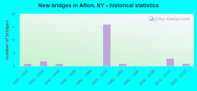
- New bridges - historical statistics
- 11920-1929
- 21930-1939
- 11940-1949
- 161970-1979
- 11980-1989
- 32010-2019
- 12020-2022

- Reconstructed bridges - Historical Statistics
- 11950-1959
- 01960-1969
- 01970-1979
- 01980-1989
- 01990-1999
- 42000-2009


- Bridge Condition - Deck
- 23.1%Excellent
- 7.7%Very good
- 7.7%Good
- 23.1%Satisfactory
- 38.5%Fair

- Bridge Condition - Superstructure
- 23.1%Excellent
- 61.5%Good
- 7.7%Satisfactory
- 7.7%Fair

- Bridge Condition - Substructure
- 15.4%Excellent
- 7.7%Very good
- 38.5%Good
- 30.8%Satisfactory
- 7.7%Fair

- Bridge Condition - Channel
- 11.1%Excellent
- 22.2%Good
- 33.3%Satisfactory
- 22.2%Fair
- 11.1%Poor

- Bridge Condition - Culverts
- 66.7%Good
- 33.3%Fair
Find on map >> Show street view
Structure Number: 100381, Location: .2 MI NE JCT SH 7 & SH 41 (Lat: 42.231108, Lng: -75.521761), Route carried "on" structure: State highway 7, Year Built: 2018, Status: Open, Structure Length: 2.47m (8.10ft), Average Daily Traffic: 1,530 (year 2019), Truck Traffic: 6%, Average Future Daily Traffic: 1,596 (year 2040), Design Load: HL 93, Features Intersected: KELSEY BROOK
Minimum Vertical Clearance: 30+ m (98+ ft), Kilometerpoint: 8.882, Lanes on structure: 2, Base Highway Network: Yes, Owner: State Highway Agency, Approaching Roadway Width: 12.2m (40.0ft), Material/Design: Prestressed concrete, Design/Construction: Box Beam or Girders - Multiple, Number Of Spans In Main Unit: 1, Length of Maximum Span: 23.8m (78.1ft), Curb-To-Curb Width: 12.3m (40.4ft), Out-to-Out Width: 13.3m (43.6ft)
Condition: Deck: Excellent, Superstructure: Excellent, Substructure: Excellent, Channel: Good, Inventory Rating: 58.1 metric tons, Method Used To Determine Inventory Rating: Load Factor (LF), Structural Evaluation: Superior to present desirable criteria, Deck Geometry: Better than present minimum criteria, Waterway Adequacy: Meets minimum limits, Approach Roadway Alignment: Equal to present desirable criteria, Length Of Structure Improvement: 2.46m (8.07ft), Designated Inspection Frequency: Every 24 months, Underwater Inspection Frequency: Every 60 months, Inspection Date: October 2021, Underwater Inspection Date: July 2018, Bridge Improvement Cost: $879,000, Roadway Improvement Cost: $515,000, Total Project Cost: $1,393,000 ( Estimate for 2021), Deck Structure Type: Concrete Cast-file-Place, Wearing Surface/Protective System: Wearing Surface: Integral Concrete, Deck Protection: Epoxy Coated Reinforcing
Find on map >> Show street view
Structure Number: 102475, Location: 2.0 MI S JCT RTS 41 + 7 (Lat: 42.206194, Lng: -75.536403), Route carried "on" structure: State highway 41, Year Built: 2020, Status: Open, Structure Length: 1.68m (5.51ft), Average Daily Traffic: 1,273 (year 2019), Truck Traffic: 11%, Average Future Daily Traffic: 1,782 (year 2039), Design Load: HL 93, Features Intersected: CORNELL CREEK
Minimum Vertical Clearance: 32.69m (107.25ft), Kilometerpoint: 1.738, Lanes on structure: 2, Owner: State Highway Agency, Approaching Roadway Width: 9.8m (32.2ft), Material/Design: Steel, Design/Construction: Stringer/Multi-beam, Number Of Spans In Main Unit: 1, Length of Maximum Span: 16.2m (53.1ft), Curb-To-Curb Width: 9.8m (32.2ft), Out-to-Out Width: 10.7m (35.1ft)
Condition: Deck: Excellent, Superstructure: Excellent, Substructure: Excellent, Channel: Excellent, Operating Rating: 68.9 metric tons, Method Used To Determine Operating Rating: Load Factor (LF), Inventory Rating: 40.8 metric tons, Method Used To Determine Inventory Rating: Load Factor (LF), Structural Evaluation: Superior to present desirable criteria, Deck Geometry: Somewhat better than minimum adequacy, Waterway Adequacy: Equal to present minimum criteria, Approach Roadway Alignment: Equal to present desirable criteria, Length Of Structure Improvement: 1.67m (5.48ft), Designated Inspection Frequency: Every 24 months, Inspection Date: October 2020, Bridge Improvement Cost: $534,000, Roadway Improvement Cost: $313,000, Total Project Cost: $847,000 ( Estimate for 2021), Deck Structure Type: Concrete Cast-file-Place, Wearing Surface/Protective System: Wearing Surface: Integral Concrete, Deck Protection: Epoxy Coated Reinforcing
Find on map >> Show street view
Structure Number: 102476, Location: JCT RTE 41+SUSQUEHANNA R (Lat: 42.227806, Lng: -75.523678), Route carried "on" structure: State highway 41, Year Built: 1948, Year Reconstructed: 2008, Status: Open, Structure Length: 11.67m (38.29ft), Average Daily Traffic: 2,408 (year 2016), Truck Traffic: 7%, Average Future Daily Traffic: 2,512 (year 2040), Design Load: HS 25 or greater, Features Intersected: SUSQUEHANNA RIVER
Minimum Vertical Clearance: 30+ m (98+ ft), Kilometerpoint: 4.586, Lanes on structure: 2, Base Highway Network: Yes, Owner: State Highway Agency, Approaching Roadway Width: 7.9m (25.9ft), Skew: 1 degrees, Material/Design: Steel, Design/Construction: Stringer/Multi-beam, Number Of Spans In Main Unit: 4, Length of Maximum Span: 28.6m (93.8ft), Curb or Sidewalk Widths: Left: 1.5m (4.9ft), Right: 1.5m (4.9ft), Curb-To-Curb Width: 7.9m (25.9ft), Out-to-Out Width: 11.5m (37.7ft)
Condition: Deck: Satisfactory, Superstructure: Good, Substructure: Satisfactory, Channel: Good, Operating Rating: 68.0 metric tons, Method Used To Determine Operating Rating: Load Factor (LF), Inventory Rating: 39.9 metric tons, Method Used To Determine Inventory Rating: Load Factor (LF), Structural Evaluation: Equal to present minimum criteria, Deck Geometry: High priority of corrective action, Waterway Adequacy: Somewhat better than minimum adequacy, Approach Roadway Alignment: Equal to present desirable criteria, Length Of Structure Improvement: 11.67m (38.29ft), Designated Inspection Frequency: Every 24 months, Underwater Inspection Frequency: Every 60 months, Inspection Date: August 2020, Underwater Inspection Date: August 2018, Bridge Improvement Cost: $3,313,000, Roadway Improvement Cost: $1,940,000, Total Project Cost: $5,253,000 ( Estimate for 2021), Deck Structure Type: Concrete Cast-file-Place, Wearing Surface/Protective System: Wearing Surface: Bituminous
Find on map >> Show street view
Structure Number: 102478, Location: 0.2 MI N JCT RTS 41 + 7 (Lat: 42.231506, Lng: -75.525936), Route carried "on" structure: State highway 41, Year Built: 1933, Year Reconstructed: 1963, Status: Open, Structure Length: 1.07m (3.51ft), Average Daily Traffic: 1,037 (year 2017), Truck Traffic: 8%, Average Future Daily Traffic: 1,081 (year 2040), Features Intersected: BUMPS CREEK
Minimum Vertical Clearance: 30+ m (98+ ft), Kilometerpoint: 5.181, Lanes on structure: 2, Base Highway Network: Yes, Owner: State Highway Agency, Approaching Roadway Width: 7.3m (24.0ft), Material/Design: Concrete, Design/Construction: Tee Beam, Number Of Spans In Main Unit: 1, Length of Maximum Span: 9.7m (31.8ft), Curb or Sidewalk Widths: Left: 1.5m (4.9ft), Right: 1.5m (4.9ft), Curb-To-Curb Width: 8.0m (26.2ft), Out-to-Out Width: 11.4m (37.4ft)
Condition: Deck: Fair, Superstructure: Fair, Substructure: Fair, Channel: Fair, Operating Rating: 45.4 metric tons, Method Used To Determine Operating Rating: Load Factor (LF), Inventory Rating: 27.2 metric tons, Method Used To Determine Inventory Rating: Load Factor (LF), Structural Evaluation: Somewhat better than minimum adequacy, Deck Geometry: Meets minimum limits, Waterway Adequacy: Somewhat better than minimum adequacy, Approach Roadway Alignment: Equal to present desirable criteria, Length Of Structure Improvement: 1.06m (3.48ft), Designated Inspection Frequency: Every 24 months, Inspection Date: July 2020, Bridge Improvement Cost: $500,000, Roadway Improvement Cost: $293,000, Total Project Cost: $793,000 ( Estimate for 2021), Deck Structure Type: Concrete Cast-file-Place, Wearing Surface/Protective System: Wearing Surface: Bituminous, Membrane: Preformed Fabric
Find on map >> Show street view
Structure Number: 1094911, Location: JCT RTS I-88 + 41 (Lat: 42.197983, Lng: -75.543747), Route carried "on" structure: Interstate 88, Year Built: 1974, Status: Open, Structure Length: 4.39m (14.40ft), Average Daily Traffic: 5,454 (year 2011), Truck Traffic: 21%, Design Load: HS 20, Features Intersected: RTE 41
Minimum Vertical Clearance: 30+ m (98+ ft), Kilometerpoint: 2.864, Lanes on structure: 2, Lanes under structure: 2, Base Highway Network: Yes, Owner: State Highway Agency, Approaching Roadway Width: 12.8m (42.0ft), Material/Design: Steel, Design/Construction: Stringer/Multi-beam, Number Of Spans In Main Unit: 1, Length of Maximum Span: 42.6m (139.8ft), Curb-To-Curb Width: 12.6m (41.3ft), Out-to-Out Width: 13.5m (44.3ft)
Condition: Deck: Fair, Superstructure: Good, Substructure: Good, Operating Rating: 58.6 metric tons, Method Used To Determine Operating Rating: Load and Resistance Factor Rating (LRFR) rating reported by rating factor(RF) method using HL-93 loadings, Inventory Rating: 45.0 metric tons, Method Used To Determine Inventory Rating: Load and Resistance Factor Rating (LRFR) rating reported by rating factor(RF) method using HL-93 loadings, Structural Evaluation: Better than present minimum criteria, Deck Geometry: Better than present minimum criteria, Underclear: Better than present minimum criteria, Approach Roadway Alignment: Equal to present desirable criteria, Length Of Structure Improvement: 4.38m (14.37ft), Designated Inspection Frequency: Every 24 months, Inspection Date: October 2021, Bridge Improvement Cost: $1,531,000, Roadway Improvement Cost: $896,000, Total Project Cost: $2,427,000 ( Estimate for 2021), Deck Structure Type: Concrete Cast-file-Place, Wearing Surface/Protective System: Wearing Surface: Monolithic Concrete
Find on map >> Show street view
Structure Number: 1094912, Location: JCT RTS I-88 + 41 (Lat: 42.197294, Lng: -75.543472), Route carried "on" structure: Interstate 88, Year Built: 1974, Status: Open, Structure Length: 4.39m (14.40ft), Average Daily Traffic: 3,823 (year 2020), Truck Traffic: 31%, Average Future Daily Traffic: 4,553 (year 2040), Design Load: HS 20, Features Intersected: RTE 41
Minimum Vertical Clearance: 30+ m (98+ ft), Kilometerpoint: 2.864, Lanes on structure: 2, Lanes under structure: 4, Base Highway Network: Yes, Owner: State Highway Agency, Approaching Roadway Width: 12.8m (42.0ft), Material/Design: Steel, Design/Construction: Stringer/Multi-beam, Number Of Spans In Main Unit: 1, Length of Maximum Span: 42.6m (139.8ft), Curb-To-Curb Width: 12.6m (41.3ft), Out-to-Out Width: 13.5m (44.3ft)
Condition: Deck: Fair, Superstructure: Good, Substructure: Good, Operating Rating: 58.6 metric tons, Method Used To Determine Operating Rating: Load and Resistance Factor Rating (LRFR) rating reported by rating factor(RF) method using HL-93 loadings, Inventory Rating: 45.0 metric tons, Method Used To Determine Inventory Rating: Load and Resistance Factor Rating (LRFR) rating reported by rating factor(RF) method using HL-93 loadings, Structural Evaluation: Better than present minimum criteria, Deck Geometry: Better than present minimum criteria, Underclear: Better than present minimum criteria, Approach Roadway Alignment: Equal to present desirable criteria, Length Of Structure Improvement: 4.38m (14.37ft), Designated Inspection Frequency: Every 24 months, Inspection Date: October 2021, Bridge Improvement Cost: $1,629,000, Roadway Improvement Cost: $954,000, Total Project Cost: $2,582,000 ( Estimate for 2021), Deck Structure Type: Concrete Cast-file-Place, Wearing Surface/Protective System: Wearing Surface: Monolithic Concrete
Find on map >> Show street view
Structure Number: 109492, Location: .3 MI E JCT I88 & SH 41 (Lat: 42.200508, Lng: -75.531047), Route carried "on" structure: Interstate 88, Year Built: 1974, Status: Open, Structure Length: 0.67m (2.20ft), Average Daily Traffic: 10,908 (year 2011), Truck Traffic: 21%, Average Future Daily Traffic: 15,271 (year 2031), Design Load: HS 20, Features Intersected: TRB CORNELL CREEK
Minimum Vertical Clearance: 30+ m (98+ ft), Kilometerpoint: 3.524, Lanes on structure: 2, Base Highway Network: Yes, Owner: State Highway Agency, Approaching Roadway Width: 12.2m (40.0ft), Skew: 4 degrees, Material/Design: Steel, Design/Construction: Culvert, Number Of Spans In Main Unit: 1, Length of Maximum Span: 6.4m (21.0ft)
Condition: Channel: Satisfactory, Culverts: Fair, Operating Rating: 77.1 metric tons, Method Used To Determine Operating Rating: Field evaluation and documented engineering judgment, Inventory Rating: 32.7 metric tons, Method Used To Determine Inventory Rating: Field evaluation and documented engineering judgment, Structural Evaluation: Somewhat better than minimum adequacy, Waterway Adequacy: High priority of corrective action, Approach Roadway Alignment: Equal to present desirable criteria, Length Of Structure Improvement: 0.67m (2.20ft), Designated Inspection Frequency: Every 24 months, Inspection Date: November 2020, Bridge Improvement Cost: $145,000, Roadway Improvement Cost: $85,000, Total Project Cost: $230,000 ( Estimate for 2021)
Find on map >> Show street view
Structure Number: 1094931, Location: 13 MI E JCT RTS I-88 + 41 (Lat: 42.206483, Lng: -75.521119), Route carried "on" structure: Interstate 88, Year Built: 1974, Year Reconstructed: 2013, Status: Open, Structure Length: 4.02m (13.19ft), Average Daily Traffic: 5,454 (year 2011), Truck Traffic: 21%, Design Load: HS 20, Features Intersected: IVES HILL ROAD
Minimum Vertical Clearance: 30+ m (98+ ft), Kilometerpoint: 5.020, Lanes on structure: 2, Lanes under structure: 2, Base Highway Network: Yes, Owner: State Highway Agency, Approaching Roadway Width: 12.2m (40.0ft), Skew: 4 degrees, Material/Design: Steel, Design/Construction: Stringer/Multi-beam, Number Of Spans In Main Unit: 1, Length of Maximum Span: 38.7m (127.0ft), Curb-To-Curb Width: 12.5m (41.0ft), Out-to-Out Width: 13.5m (44.3ft)
Condition: Deck: Fair, Superstructure: Good, Substructure: Good, Operating Rating: 52.8 metric tons, Method Used To Determine Operating Rating: Load and Resistance Factor Rating (LRFR) rating reported by rating factor(RF) method using HL-93 loadings, Inventory Rating: 40.5 metric tons, Method Used To Determine Inventory Rating: Load and Resistance Factor Rating (LRFR) rating reported by rating factor(RF) method using HL-93 loadings, Structural Evaluation: Better than present minimum criteria, Deck Geometry: Better than present minimum criteria, Underclear: Somewhat better than minimum adequacy, Approach Roadway Alignment: Equal to present desirable criteria, Length Of Structure Improvement: 4.02m (13.19ft), Designated Inspection Frequency: Every 24 months, Inspection Date: September 2021, Bridge Improvement Cost: $1,539,000, Roadway Improvement Cost: $901,000, Total Project Cost: $2,440,000 ( Estimate for 2021), Deck Structure Type: Concrete Cast-file-Place, Wearing Surface/Protective System: Wearing Surface: Monolithic Concrete
Find on map >> Show street view
Structure Number: 1094932, Location: 13 MI E JCT RTS I-88 + 41 (Lat: 42.205719, Lng: -75.520969), Route carried "on" structure: Interstate 88, Year Built: 1974, Year Reconstructed: 2013, Status: Open, Structure Length: 4.30m (14.11ft), Average Daily Traffic: 3,823 (year 2020), Truck Traffic: 31%, Average Future Daily Traffic: 4,553 (year 2040), Design Load: HS 20, Features Intersected: IVES HILL ROAD
Minimum Vertical Clearance: 30+ m (98+ ft), Kilometerpoint: 5.020, Lanes on structure: 2, Lanes under structure: 2, Base Highway Network: Yes, Owner: State Highway Agency, Approaching Roadway Width: 12.2m (40.0ft), Skew: 4 degrees, Material/Design: Steel, Design/Construction: Stringer/Multi-beam, Number Of Spans In Main Unit: 1, Length of Maximum Span: 42.0m (137.8ft), Curb-To-Curb Width: 12.5m (41.0ft), Out-to-Out Width: 13.5m (44.3ft)
Condition: Deck: Fair, Superstructure: Good, Substructure: Good, Operating Rating: 52.8 metric tons, Method Used To Determine Operating Rating: Load and Resistance Factor Rating (LRFR) rating reported by rating factor(RF) method using HL-93 loadings, Inventory Rating: 40.8 metric tons, Method Used To Determine Inventory Rating: Load and Resistance Factor Rating (LRFR) rating reported by rating factor(RF) method using HL-93 loadings, Structural Evaluation: Better than present minimum criteria, Deck Geometry: Better than present minimum criteria, Underclear: Meets minimum limits, Approach Roadway Alignment: Equal to present desirable criteria, Length Of Structure Improvement: 4.29m (14.07ft), Designated Inspection Frequency: Every 24 months, Inspection Date: September 2021, Bridge Improvement Cost: $1,857,000, Roadway Improvement Cost: $1,088,000, Total Project Cost: $2,945,000 ( Estimate for 2021), Deck Structure Type: Concrete Cast-file-Place, Wearing Surface/Protective System: Wearing Surface: Monolithic Concrete
Find on map >> Show street view
Structure Number: 1094949, Location: JCT RTE I-88 + AFTON CONN (Lat: 42.222564, Lng: -75.512544), Route carried "on" structure: Ramp State highway 991M, Year Built: 1974, Year Reconstructed: 2008, Status: Open, Structure Length: 8.66m (28.41ft), Average Daily Traffic: 1,884 (year 2019), Truck Traffic: 6%, Average Future Daily Traffic: 1,965 (year 2040), Design Load: HS 20, Features Intersected: 88I 88I92021044, RTE I88
Minimum Vertical Clearance: 30+ m (98+ ft), Kilometerpoint: 0.644, Lanes on structure: 2, Lanes under structure: 5, Base Highway Network: Yes, Owner: State Highway Agency, Approaching Roadway Width: 15.5m (50.9ft), Skew: 32 degrees, Material/Design: Steel continuous, Design/Construction: Stringer/Multi-beam, Number Of Spans In Main Unit: 2, Length of Maximum Span: 42.9m (140.7ft), Curb-To-Curb Width: 15.2m (49.9ft), Out-to-Out Width: 16.2m (53.1ft)
Condition: Deck: Good, Superstructure: Good, Substructure: Good, Operating Rating: 76.2 metric tons, Method Used To Determine Operating Rating: Load Factor (LF), Inventory Rating: 45.4 metric tons, Method Used To Determine Inventory Rating: Load Factor (LF), Structural Evaluation: Better than present minimum criteria, Deck Geometry: Superior to present desirable criteria, Underclear: Equal to present minimum criteria, Approach Roadway Alignment: Equal to present desirable criteria, Length Of Structure Improvement: 8.65m (28.38ft), Designated Inspection Frequency: Every 24 months, Inspection Date: August 2020, Bridge Improvement Cost: $3,358,000, Roadway Improvement Cost: $1,967,000, Total Project Cost: $5,325,000 ( Estimate for 2021), Deck Structure Type: Concrete Cast-file-Place, Wearing Surface/Protective System: Wearing Surface: Bituminous
Find on map >> Show street view
Structure Number: 1094951, Location: 42 MI SW JCT RTS I-88+206 (Lat: 42.234917, Lng: -75.493653), Route carried "on" structure: Interstate 88, Year Built: 1974, Status: Open, Structure Length: 8.81m (28.90ft), Average Daily Traffic: 4,926 (year 2014), Truck Traffic: 28%, Average Future Daily Traffic: 6,896 (year 2034), Design Load: HS 20, Features Intersected: MELONDY HILL RD
Minimum Vertical Clearance: 30+ m (98+ ft), Kilometerpoint: 9.413, Lanes on structure: 2, Lanes under structure: 2, Base Highway Network: Yes, Owner: State Highway Agency, Approaching Roadway Width: 12.2m (40.0ft), Material/Design: Steel continuous, Design/Construction: Stringer/Multi-beam, Number Of Spans In Main Unit: 3, Length of Maximum Span: 40.5m (132.9ft), Curb-To-Curb Width: 12.5m (41.0ft), Out-to-Out Width: 13.4m (44.0ft)
Condition: Deck: Satisfactory, Superstructure: Good, Substructure: Satisfactory, Operating Rating: 61.7 metric tons, Method Used To Determine Operating Rating: Load Factor (LF), Inventory Rating: 37.2 metric tons, Method Used To Determine Inventory Rating: Load Factor (LF), Structural Evaluation: Equal to present minimum criteria, Deck Geometry: Better than present minimum criteria, Underclear: Meets minimum limits, Approach Roadway Alignment: Equal to present desirable criteria, Length Of Structure Improvement: 8.80m (28.87ft), Designated Inspection Frequency: Every 24 months, Inspection Date: June 2020, Bridge Improvement Cost: $2,709,000, Roadway Improvement Cost: $1,586,000, Total Project Cost: $4,295,000 ( Estimate for 2021), Deck Structure Type: Concrete Cast-file-Place, Wearing Surface/Protective System: Wearing Surface: Monolithic Concrete
Find on map >> Show street view
Structure Number: 1094952, Location: 42 MI SW JCT RTS I-88+206 (Lat: 42.234947, Lng: -75.492856), Route carried "on" structure: Interstate 88, Year Built: 1974, Status: Open, Structure Length: 7.38m (24.21ft), Average Daily Traffic: 3,868 (year 2019), Truck Traffic: 26%, Average Future Daily Traffic: 4,607 (year 2040), Design Load: HS 20, Features Intersected: MELONDY HILL RD
Minimum Vertical Clearance: 30+ m (98+ ft), Kilometerpoint: 9.413, Lanes on structure: 2, Lanes under structure: 2, Base Highway Network: Yes, Owner: State Highway Agency, Approaching Roadway Width: 12.2m (40.0ft), Material/Design: Steel continuous, Design/Construction: Stringer/Multi-beam, Number Of Spans In Main Unit: 3, Length of Maximum Span: 36.5m (119.8ft), Curb-To-Curb Width: 12.5m (41.0ft), Out-to-Out Width: 13.4m (44.0ft)
Condition: Deck: Satisfactory, Superstructure: Satisfactory, Substructure: Satisfactory, Operating Rating: 53.5 metric tons, Method Used To Determine Operating Rating: Load Factor (LF), Inventory Rating: 31.8 metric tons, Method Used To Determine Inventory Rating: Load Factor (LF), Structural Evaluation: Equal to present minimum criteria, Deck Geometry: Better than present minimum criteria, Underclear: Meets minimum limits, Approach Roadway Alignment: Equal to present desirable criteria, Length Of Structure Improvement: 7.37m (24.18ft), Designated Inspection Frequency: Every 24 months, Inspection Date: June 2020, Bridge Improvement Cost: $2,280,000, Roadway Improvement Cost: $1,335,000, Total Project Cost: $3,615,000 ( Estimate for 2021), Deck Structure Type: Concrete Cast-file-Place, Wearing Surface/Protective System: Wearing Surface: Monolithic Concrete
Find on map >> Show street view
Structure Number: 335013, Location: .1 MI NORTH OF AFTON (Lat: 42.240286, Lng: -75.526333), Route carried "on" structure: Spur Other road , Year Built: 1984, Status: Open, Structure Length: 3.66m (12.01ft), Average Daily Traffic: 530 (year 2016), Truck Traffic: 3%, Average Future Daily Traffic: 742 (year 2036), Design Load: HS 20, Features Intersected: KELSEY CREEK, Facility Carried by Structure: ALGERINE ROAD
Minimum Vertical Clearance: 30+ m (98+ ft), Kilometerpoint: 0.113, Lanes on structure: 2, Owner: County Highway Agency, Approaching Roadway Width: 5.5m (18.0ft), Material/Design: Steel, Design/Construction: Stringer/Multi-beam, Number Of Spans In Main Unit: 1, Length of Maximum Span: 35.0m (114.8ft), Curb-To-Curb Width: 8.5m (27.9ft), Out-to-Out Width: 9.1m (29.9ft)
Condition: Deck: Very good, Superstructure: Good, Substructure: Satisfactory, Channel: Poor, Operating Rating: 45.4 metric tons, Method Used To Determine Operating Rating: Load Factor (LF), Inventory Rating: 26.3 metric tons, Method Used To Determine Inventory Rating: Load Factor (LF), Structural Evaluation: Equal to present minimum criteria, Deck Geometry: Somewhat better than minimum adequacy, Waterway Adequacy: Somewhat better than minimum adequacy, Approach Roadway Alignment: Equal to present desirable criteria, Length Of Structure Improvement: 3.65m (11.98ft), Designated Inspection Frequency: Every 24 months, Inspection Date: October 2021, Bridge Improvement Cost: $882,000, Roadway Improvement Cost: $517,000, Total Project Cost: $1,399,000 ( Estimate for 2021), Deck Structure Type: Concrete Cast-file-Place, Wearing Surface/Protective System: Wearing Surface: Integral Concrete, Deck Protection: Epoxy Coated Reinforcing
Find on map >> Show street view
Structure Number: 335015, Location: COUNTY ROAD 17 (Lat: 42.274039, Lng: -75.542500), Route carried "on" structure: County highway , Year Built: 2013, Status: Open, Structure Length: 1.52m (4.99ft), Average Daily Traffic: 313 (year 2017), Truck Traffic: 4%, Average Future Daily Traffic: 438 (year 2037), Features Intersected: WILKINS BROOK, Facility Carried by Structure: COUNTY ROAD 17
Minimum Vertical Clearance: 30+ m (98+ ft), Kilometerpoint: 0.692, Lanes on structure: 2, Owner: County Highway Agency, Approaching Roadway Width: 7.9m (25.9ft), Skew: 2 degrees, Material/Design: Prestressed concrete, Design/Construction: Box Beam or Girders - Multiple, Number Of Spans In Main Unit: 1, Length of Maximum Span: 14.6m (47.9ft), Curb-To-Curb Width: 9.1m (29.9ft), Out-to-Out Width: 9.8m (32.2ft)
Condition: Deck: Excellent, Superstructure: Excellent, Substructure: Very good, Channel: Satisfactory, Operating Rating: 64.4 metric tons, Method Used To Determine Operating Rating: Load Factor (LF), Inventory Rating: 29.9 metric tons, Method Used To Determine Inventory Rating: Load Factor (LF), Structural Evaluation: Better than present minimum criteria, Deck Geometry: Equal to present minimum criteria, Waterway Adequacy: Equal to present minimum criteria, Approach Roadway Alignment: Equal to present desirable criteria, Length Of Structure Improvement: 1.52m (4.99ft), Designated Inspection Frequency: Every 24 months, Inspection Date: October 2021, Bridge Improvement Cost: $544,000, Roadway Improvement Cost: $318,000, Total Project Cost: $862,000 ( Estimate for 2021), Wearing Surface/Protective System: Wearing Surface: Bituminous, Membrane: Other
Find on map >> Show street view
Structure Number: 335022, Location: 1/4 mi. north of NY 206 (Lat: 42.268106, Lng: -75.543269), Route carried "on" structure: County highway , Year Built: 2012, Status: Open, Structure Length: 0.67m (2.20ft), Average Daily Traffic: 313 (year 2017), Truck Traffic: 4%, Average Future Daily Traffic: 438 (year 2037), Features Intersected: TRIB.KELSEY CREEK, Facility Carried by Structure: COUNTY ROAD 17
Minimum Vertical Clearance: 30+ m (98+ ft), Kilometerpoint: 0.048, Lanes on structure: 2, Owner: County Highway Agency, Approaching Roadway Width: 11.0m (36.1ft), Skew: 1 degrees, Material/Design: Concrete, Design/Construction: Culvert, Number Of Spans In Main Unit: 1, Length of Maximum Span: 6.4m (21.0ft), Curb-To-Curb Width: 10.8m (35.4ft), Out-to-Out Width: 12.9m (42.3ft)
Condition: Channel: Fair, Culverts: Good, Operating Rating: 77.1 metric tons, Method Used To Determine Operating Rating: Field evaluation and documented engineering judgment, Inventory Rating: 40.8 metric tons, Method Used To Determine Inventory Rating: Field evaluation and documented engineering judgment, Structural Evaluation: Better than present minimum criteria, Deck Geometry: Better than present minimum criteria, Waterway Adequacy: Somewhat better than minimum adequacy, Approach Roadway Alignment: Equal to present desirable criteria, Length Of Structure Improvement: 0.67m (2.20ft), Designated Inspection Frequency: Every 24 months, Inspection Date: September 2020, Bridge Improvement Cost: $153,000, Roadway Improvement Cost: $89,000, Total Project Cost: $242,000 ( Estimate for 2021)
Find on map >> Show street view
Structure Number: 336722, Location: 1.5 MI E OF AFTON (Lat: 42.234911, Lng: -75.493267), Route carried "on" structure: Alternate Other road , Year Built: 1974, Status: Open, Structure Length: 0.88m (2.89ft), Average Daily Traffic: 207 (year 2016), Truck Traffic: 5%, Average Future Daily Traffic: 290 (year 2036), Design Load: HS 20, Features Intersected: LANDERS CREEK, RTE I88, Facility Carried by Structure: MELONDY HILL ROAD
Minimum Vertical Clearance: 5.38m (17.65ft), Kilometerpoint: 6.066, Lanes on structure: 2, Owner: County Highway Agency, Approaching Roadway Width: 6.1m (20.0ft), Skew: 4 degrees, Material/Design: Steel, Design/Construction: Culvert, Number Of Spans In Main Unit: 2, Length of Maximum Span: 3.6m (11.8ft)
Condition: Channel: Satisfactory, Culverts: Good, Operating Rating: 74.8 metric tons, Method Used To Determine Operating Rating: Field evaluation and documented engineering judgment, Inventory Rating: 29.4 metric tons, Method Used To Determine Inventory Rating: Field evaluation and documented engineering judgment, Structural Evaluation: Better than present minimum criteria, Waterway Adequacy: Meets minimum limits, Approach Roadway Alignment: Equal to present minimum criteria, Length Of Structure Improvement: 0.88m (2.89ft), Designated Inspection Frequency: Every 24 months, Inspection Date: July 2020, Bridge Improvement Cost: $95,000, Roadway Improvement Cost: $56,000, Total Project Cost: $151,000 ( Estimate for 2021)
Find on map >> Show street view
Structure Number: 1094911, Location: JCT RTS I-88 + 41 (Lat: 42.197983, Lng: -75.543747), Route carried "under" structure: State highway 41, Year Built: 1974, Structure Length: 0. m, Average Daily Traffic: 1,796 (year 1999), Features Intersected: RTE 41, Facility Carried by Structure: RTE I88
Minimum Vertical Clearance: 4.95m (16.24ft), Kilometerpoint: 0.322, Lanes on structure: 2, Lanes under structure: 2, Material/Design: Steel, Design/Construction: Stringer/Multi-beam, Length of Maximum Span: 42.6m (139.8ft)
Find on map >> Show street view
Structure Number: 1094912, Location: JCT RTS I-88 + 41 (Lat: 42.197294, Lng: -75.543472), Route carried "under" structure: State highway 41, Year Built: 1974, Structure Length: 0. m, Average Daily Traffic: 1,796 (year 1999), Features Intersected: RTE 41, Facility Carried by Structure: RTE I88
Minimum Vertical Clearance: 6.19m (20.31ft), Kilometerpoint: 0.241, Lanes on structure: 2, Lanes under structure: 4, Material/Design: Steel, Design/Construction: Stringer/Multi-beam, Length of Maximum Span: 42.6m (139.8ft)
Find on map >> Show street view
Structure Number: 1094931, Location: 13 MI E JCT RTS I-88 + 41 (Lat: 42.206483, Lng: -75.521119), Route carried "under" structure: Other road , Year Built: 1974, Structure Length: 0. m, Features Intersected: IVES HILL ROAD, Facility Carried by Structure: RTE I88
Minimum Vertical Clearance: 4.65m (15.26ft), Kilometerpoint: 0.000, Lanes on structure: 2, Lanes under structure: 2, Material/Design: Steel, Design/Construction: Stringer/Multi-beam, Length of Maximum Span: 38.7m (127.0ft)
Find on map >> Show street view
Structure Number: 1094932, Location: 13 MI E JCT RTS I-88 + 41 (Lat: 42.205719, Lng: -75.520969), Route carried "under" structure: Other road , Year Built: 1974, Structure Length: 0. m, Features Intersected: IVES HILL ROAD, Facility Carried by Structure: RTE I88
Minimum Vertical Clearance: 4.62m (15.16ft), Kilometerpoint: 0.933, Lanes on structure: 2, Lanes under structure: 2, Material/Design: Steel, Design/Construction: Stringer/Multi-beam, Length of Maximum Span: 42.0m (137.8ft)
Find on map >> Show street view
Structure Number: 1094949, Location: JCT RTE I-88 + AFTON CONN (Lat: 42.222564, Lng: -75.512544), Route carried "under" structure: Interstate 88, Year Built: 1974, Structure Length: 0. m, Average Daily Traffic: 10,024 (year 2000), Features Intersected: 88I 88I92021044, RTE I88, Facility Carried by Structure: RTE 991M
Minimum Vertical Clearance: 7.62m (25.00ft), Kilometerpoint: 7.160, Lanes on structure: 2, Lanes under structure: 3, Material/Design: Steel continuous, Design/Construction: Stringer/Multi-beam, Length of Maximum Span: 42.9m (140.7ft)
Find on map >> Show street view
Structure Number: 1094951, Location: 42 MI SW JCT RTS I-88+206 (Lat: 42.234917, Lng: -75.493653), Route carried "under" structure: Other road , Year Built: 1974, Structure Length: 0. m, Average Daily Traffic: 104 (year 2016), Truck Traffic: 5%, Features Intersected: MELONDY HILL RD, Facility Carried by Structure: RTE I88
Minimum Vertical Clearance: 5.86m (19.23ft), Kilometerpoint: 6.082, Lanes on structure: 2, Lanes under structure: 2, Material/Design: Steel continuous, Design/Construction: Stringer/Multi-beam, Length of Maximum Span: 40.5m (132.9ft)
Find on map >> Show street view
Structure Number: 1094952, Location: 42 MI SW JCT RTS I-88+206 (Lat: 42.234947, Lng: -75.492856), Route carried "under" structure: Other road , Year Built: 1974, Structure Length: 0. m, Average Daily Traffic: 104 (year 2016), Truck Traffic: 5%, Features Intersected: MELONDY HILL RD, Facility Carried by Structure: RTE I88
Minimum Vertical Clearance: 5.33m (17.49ft), Kilometerpoint: 6.066, Lanes on structure: 2, Lanes under structure: 2, Material/Design: Steel continuous, Design/Construction: Stringer/Multi-beam, Length of Maximum Span: 36.5m (119.8ft)
Find on map >> Show street view
Structure Number: 70038, Location: 2.9 MI SW JCT RTS 7 + 41 (Lat: 42.214172, Lng: -75.566956), Route carried "under" structure: State highway 7, Year Built: 1926, Structure Length: 0. m, Average Daily Traffic: 2,367 (year 1999), Features Intersected: RTE 7, Facility Carried by Structure: NORFOLK SOUTHERN M
Minimum Vertical Clearance: 4.70m (15.42ft), Kilometerpoint: 3.797, Lanes under structure: 2, Material/Design: Steel, Design/Construction: Girder and Floorbeam System, Length of Maximum Span: 19.5m (64.0ft)
Find on map >> Show street view
Structure Number: 702477, Location: 0.1 MI SE JCT RTS 41 + 7 (Lat: 42.228625, Lng: -75.524339), Route carried "under" structure: State highway 41, Year Built: 1934, Structure Length: 0. m, Average Daily Traffic: 3,958 (year 2000), Features Intersected: RTE 41, Facility Carried by Structure: NORFOLK SOUTHERN M
Minimum Vertical Clearance: 4.32m (14.17ft), Kilometerpoint: 4.827, Lanes under structure: 2, Material/Design: Steel, Design/Construction: Stringer/Multi-beam, Length of Maximum Span: 14.9m (48.9ft)