Bridge Statistics for Air Force Academy, Colorado (CO)
Condition, Traffic, Stress, Structural Evaluation, Project Costs
- National Bridge Inventory (NBI) Statistics
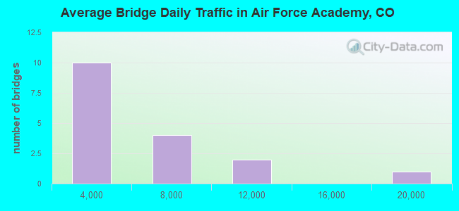
- 17Number of bridges
- 279ft / 84.8mTotal length
- $309,000Total costs
- 63,461Total average daily traffic
- 76,075Total future (year 2034) average daily traffic
- National Bridge Inventory (NBI) Registered Bridges for Air Force Academy
- No street view available for this location

- New bridges - historical statistics
- 141950-1959
- 11980-1989
- 12000-2009
- 12010-2019
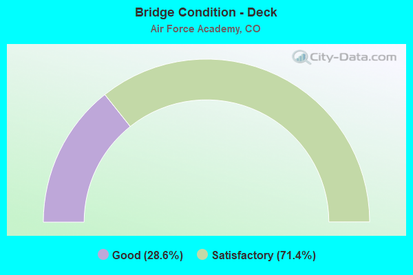
- Bridge Condition - Deck
- 28.6%Good
- 71.4%Satisfactory
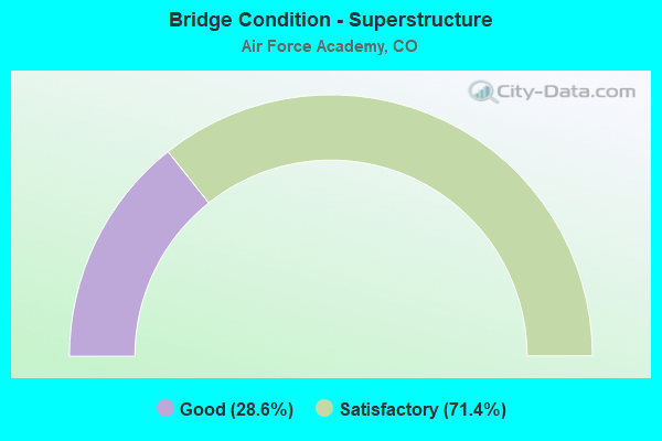
- Bridge Condition - Superstructure
- 28.6%Good
- 71.4%Satisfactory
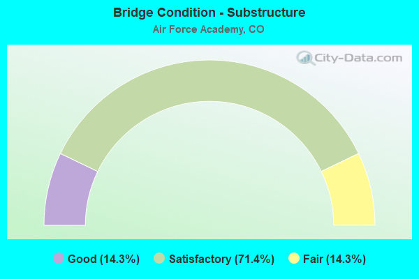
- Bridge Condition - Substructure
- 14.3%Good
- 71.4%Satisfactory
- 14.3%Fair
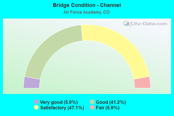
- Bridge Condition - Channel
- 5.9%Very good
- 41.2%Good
- 47.1%Satisfactory
- 5.9%Fair
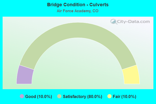
- Bridge Condition - Culverts
- 10.0%Good
- 80.0%Satisfactory
- 10.0%Fair
Find on map >> Show street view
Structure Number: AFCOXQPZ10553, Location: 0.5 MI WEST OF I-25 EXIT (Lat: 39.023611, Lng: -104.843889), Route carried "on" structure: Federal lands road , Year Built: 1958, Status: Open, Structure Length: 14.72m (48.29ft), Average Daily Traffic: 5,000 (year 2014), Average Future Daily Traffic: 6,000 (year 2034), Design Load: HS 20, Features Intersected: MONUMENT CREEK AND UPRR, Facility Carried by Structure: NORTH GATE BLVD WB
Minimum Vertical Clearance: 30+ m (98+ ft), Kilometerpoint: 0.000, Lanes on structure: 2, Owner: Air Force, Approaching Roadway Width: 9.1m (29.9ft), Material/Design: Prestressed concrete, Design/Construction: Stringer/Multi-beam, Number Of Spans In Main Unit: 4, Length of Maximum Span: 36.6m (120.1ft), Curb or Sidewalk Widths: Left: 0.9m (3.0ft), Right: 0.0m, Curb-To-Curb Width: 8.4m (27.6ft), Out-to-Out Width: 11.2m (36.7ft)
Condition: Deck: Satisfactory, Superstructure: Satisfactory, Substructure: Satisfactory, Channel: Good, Operating Rating: 69.8 metric tons, Method Used To Determine Operating Rating: Load Factor (LF), Inventory Rating: 29.9 metric tons, Method Used To Determine Inventory Rating: Load Factor (LF), Structural Evaluation: Equal to present minimum criteria, Deck Geometry: High priority of corrective action, Underclear: Equal to present desirable criteria, Waterway Adequacy: Superior to present desirable criteria, Approach Roadway Alignment: Equal to present desirable criteria, Length Of Structure Improvement: 14.72m (48.29ft), Designated Inspection Frequency: Every 24 months, Inspection Date: September 2020, Deck Structure Type: Concrete Cast-file-Place, Wearing Surface/Protective System: Wearing Surface: Epoxy Overlay
Find on map >> Show street view
Structure Number: AFCOXQPZ10554, Location: 0.5 MI WEST OF I-25 EXIT (Lat: 39.023444, Lng: -104.844417), Route carried "on" structure: Federal lands road , Year Built: 1958, Status: Open, Structure Length: 14.72m (48.29ft), Average Daily Traffic: 5,000 (year 2014), Average Future Daily Traffic: 6,000 (year 2034), Design Load: HS 20, Features Intersected: MONUMENT CREEK AND UPRR, Facility Carried by Structure: NORTH GATE BLVD EB
Minimum Vertical Clearance: 30+ m (98+ ft), Kilometerpoint: 0.000, Lanes on structure: 2, Owner: Air Force, Approaching Roadway Width: 9.1m (29.9ft), Material/Design: Prestressed concrete, Design/Construction: Stringer/Multi-beam, Number Of Spans In Main Unit: 4, Length of Maximum Span: 36.6m (120.1ft), Curb or Sidewalk Widths: Left: 0.9m (3.0ft), Right: 0.0m, Curb-To-Curb Width: 8.4m (27.6ft), Out-to-Out Width: 11.2m (36.7ft)
Condition: Deck: Satisfactory, Superstructure: Satisfactory, Substructure: Satisfactory, Channel: Good, Operating Rating: 70.7 metric tons, Method Used To Determine Operating Rating: Load Factor (LF), Inventory Rating: 31.7 metric tons, Method Used To Determine Inventory Rating: Load Factor (LF), Structural Evaluation: Equal to present minimum criteria, Deck Geometry: High priority of corrective action, Underclear: Equal to present desirable criteria, Waterway Adequacy: Superior to present desirable criteria, Approach Roadway Alignment: Equal to present desirable criteria, Length Of Structure Improvement: 14.72m (48.29ft), Designated Inspection Frequency: Every 24 months, Inspection Date: September 2020, Deck Structure Type: Concrete Cast-file-Place, Wearing Surface/Protective System: Wearing Surface: Epoxy Overlay
Find on map >> Show street view
Structure Number: AFCOXQPZ10555, Location: 2000' S. OF NORTH GATE DR (Lat: 39.015861, Lng: -104.849083), Route carried "on" structure: Federal lands road , Year Built: 1958, Year Reconstructed: 2011, Status: Open, Structure Length: 11.06m (36.29ft), Average Daily Traffic: 1,760 (year 2014), Average Future Daily Traffic: 2,112 (year 2034), Design Load: HS 20, Features Intersected: DEADMANS CREEK, Facility Carried by Structure: STADIUM BLVD NB
Minimum Vertical Clearance: 30+ m (98+ ft), Kilometerpoint: 0.000, Lanes on structure: 2, Owner: Air Force, Approaching Roadway Width: 7.3m (24.0ft), Material/Design: Prestressed concrete, Design/Construction: Stringer/Multi-beam, Number Of Spans In Main Unit: 3, Length of Maximum Span: 36.6m (120.1ft), Curb or Sidewalk Widths: Left: 0.0m, Right: 1.3m (4.3ft), Curb-To-Curb Width: 8.5m (27.9ft), Out-to-Out Width: 11.0m (36.1ft)
Condition: Deck: Satisfactory, Superstructure: Satisfactory, Substructure: Fair, Channel: Satisfactory, Operating Rating: 50.8 metric tons, Method Used To Determine Operating Rating: Load Factor (LF), Inventory Rating: 30.8 metric tons, Method Used To Determine Inventory Rating: Load Factor (LF), Structural Evaluation: Somewhat better than minimum adequacy, Deck Geometry: High priority of corrective action, Waterway Adequacy: Equal to present desirable criteria, Approach Roadway Alignment: Equal to present desirable criteria, Designated Inspection Frequency: Every 24 months, Inspection Date: September 2020, Deck Structure Type: Concrete Precast Panels, Wearing Surface/Protective System: Wearing Surface: Latex Concrete
Find on map >> Show street view
Structure Number: AFCOXQPZ10556, Location: 2000' S. OF NORTH GATE DR (Lat: 39.016389, Lng: -104.849722), Route carried "on" structure: Federal lands road , Year Built: 1958, Year Reconstructed: 2011, Status: Open, Structure Length: 11.06m (36.29ft), Average Daily Traffic: 1,760 (year 2014), Average Future Daily Traffic: 2,034 (year 2034), Design Load: HS 20, Features Intersected: DEADMANS CREEK, Facility Carried by Structure: STADIUM BLVD SB
Minimum Vertical Clearance: 30+ m (98+ ft), Kilometerpoint: 0.000, Lanes on structure: 2, Owner: Air Force, Approaching Roadway Width: 9.1m (29.9ft), Material/Design: Prestressed concrete, Design/Construction: Stringer/Multi-beam, Number Of Spans In Main Unit: 3, Length of Maximum Span: 36.6m (120.1ft), Curb or Sidewalk Widths: Left: 1.3m (4.3ft), Right: 0.0m, Curb-To-Curb Width: 8.5m (27.9ft), Out-to-Out Width: 11.0m (36.1ft)
Condition: Deck: Satisfactory, Superstructure: Satisfactory, Substructure: Satisfactory, Channel: Good, Operating Rating: 50.8 metric tons, Method Used To Determine Operating Rating: Load Factor (LF), Inventory Rating: 30.8 metric tons, Method Used To Determine Inventory Rating: Load Factor (LF), Structural Evaluation: Equal to present minimum criteria, Deck Geometry: High priority of corrective action, Waterway Adequacy: Superior to present desirable criteria, Approach Roadway Alignment: Equal to present desirable criteria, Designated Inspection Frequency: Every 24 months, Inspection Date: September 2020, Bridge Improvement Cost: $7,000, Roadway Improvement Cost: $1,000, Total Project Cost: $11,000 ( Estimate for 2020), Deck Structure Type: Concrete Precast Panels, Wearing Surface/Protective System: Wearing Surface: Low Slump Concrete
Find on map >> Show street view
Structure Number: AFCOXQPZ10557, Location: 0.1 MI. S. OF STADIUM BLV (Lat: 38.974467, Lng: -104.832494), Route carried "on" structure: Federal lands road , Year Built: 1958, Status: Open, Structure Length: 18.36m (60.24ft), Average Daily Traffic: 18,815 (year 2014), Average Future Daily Traffic: 22,578 (year 2034), Design Load: HS 20, Features Intersected: MONUMENT CREEK AND UPRR, Facility Carried by Structure: SOUTH GATE BLVD
Minimum Vertical Clearance: 30+ m (98+ ft), Kilometerpoint: 0.000, Lanes on structure: 4, Owner: Air Force, Approaching Roadway Width: 26.8m (87.9ft), Skew: 30 degrees, Material/Design: Prestressed concrete, Design/Construction: Stringer/Multi-beam, Number Of Spans In Main Unit: 5, Length of Maximum Span: 36.7m (120.4ft), Curb or Sidewalk Widths: Left: 0.9m (3.0ft), Right: 0.9m (3.0ft), Curb-To-Curb Width: 8.5m (27.9ft), Out-to-Out Width: 21.6m (70.9ft)
Condition: Deck: Satisfactory, Superstructure: Satisfactory, Substructure: Satisfactory, Channel: Satisfactory, Operating Rating: 52.2 metric tons, Method Used To Determine Operating Rating: Load Factor (LF), Inventory Rating: 30.4 metric tons, Method Used To Determine Inventory Rating: Load Factor (LF), Structural Evaluation: Equal to present minimum criteria, Deck Geometry: High priority of replacement, Underclear: Somewhat better than minimum adequacy, Waterway Adequacy: Superior to present desirable criteria, Approach Roadway Alignment: Equal to present desirable criteria, Designated Inspection Frequency: Every 24 months, Inspection Date: September 2020, Deck Structure Type: Concrete Cast-file-Place, Wearing Surface/Protective System: Wearing Surface: Bituminous
Find on map >> Show street view
Structure Number: AFCOXQPZ10559, Location: 100' N. OF NON-POTABLE RE (Lat: 39.001389, Lng: -104.833889), Route carried "on" structure: Federal lands road , Year Built: 2004, Status: Posted for load, Structure Length: 2.74m (8.99ft), Average Daily Traffic: 15 (year 2014), Average Future Daily Traffic: 18 (year 2034), Design Load: H 10, Features Intersected: NON-POTABLE RESERVOIR #1, Facility Carried by Structure: HUSTED ROAD
Minimum Vertical Clearance: 30+ m (98+ ft), Kilometerpoint: 0.000, Lanes on structure: 1, Owner: Air Force, Approaching Roadway Width: 3.0m (9.8ft), Material/Design: Steel, Design/Construction: Truss - Thru, Number Of Spans In Main Unit: 1, Length of Maximum Span: 27.4m (89.9ft), Curb-To-Curb Width: 3.5m (11.5ft), Out-to-Out Width: 3.7m (12.1ft)
Condition: Deck: Good, Superstructure: Good, Substructure: Satisfactory, Channel: Good, Deck Geometry: High priority of corrective action, Waterway Adequacy: Equal to present desirable criteria, Approach Roadway Alignment: Equal to present desirable criteria, Bridge Posting: Required (Relationship of Operating Rating to Maximum Legal Load: > 39.9% below), Designated Inspection Frequency: Every 24 months, Critical Feature Inspection Frequency: Every 24 months, Inspection Date: September 2020, Critical Feature Inspection Date: September 2020, Deck Structure Type: Open Grating
Find on map >> Show street view
Structure Number: AFCOXQPZ10621, Location: 0.5 MI SOUTHWEST OF PINE (Lat: 38.973250, Lng: -104.877083), Route carried "on" structure: Federal lands road , Year Built: 1980, Status: Open, Structure Length: 1.27m (4.17ft), Average Daily Traffic: 50 (year 2014), Average Future Daily Traffic: 60 (year 2034), Design Load: HS 20, Features Intersected: WEST MONUMENT CREEK, Facility Carried by Structure: WEST MONUMENT CREE
Minimum Vertical Clearance: 30+ m (98+ ft), Kilometerpoint: 0.000, Lanes on structure: 2, Owner: Air Force, Approaching Roadway Width: 7.9m (25.9ft), Material/Design: Steel, Design/Construction: Culvert, Number Of Spans In Main Unit: 2, Length of Maximum Span: 5.1m (16.7ft)
Condition: Channel: Satisfactory, Culverts: Good, Operating Rating: 89.8 metric tons, Method Used To Determine Operating Rating: Load Factor (LF), Inventory Rating: 89.8 metric tons, Method Used To Determine Inventory Rating: Load Factor (LF), Structural Evaluation: Better than present minimum criteria, Waterway Adequacy: Somewhat better than minimum adequacy, Approach Roadway Alignment: Equal to present desirable criteria, Designated Inspection Frequency: Every 24 months, Inspection Date: September 2020
Find on map >> Show street view
Structure Number: AFCOXQPZ10622, Location: 800' N OF COMMUNITY CENTE (Lat: 38.989194, Lng: -104.849806), Route carried "on" structure: Federal lands road , Year Built: 1958, Status: Open, Structure Length: 0.82m (2.69ft), Average Daily Traffic: 261 (year 2014), Average Future Daily Traffic: 313 (year 2034), Features Intersected: DOUGLASS VALLEY TRIBUTAR, Facility Carried by Structure: EAST DOUGLASS VALL
Minimum Vertical Clearance: 30+ m (98+ ft), Kilometerpoint: 0.000, Lanes on structure: 2, Owner: Air Force, Approaching Roadway Width: 11.7m (38.4ft), Skew: 2 degrees, Material/Design: Concrete, Design/Construction: Culvert, Number Of Spans In Main Unit: 2, Length of Maximum Span: 4.0m (13.1ft)
Condition: Channel: Satisfactory, Culverts: Satisfactory, Operating Rating: 54.4 metric tons, Method Used To Determine Operating Rating: Load Factor (LF), Inventory Rating: 32.7 metric tons, Method Used To Determine Inventory Rating: Load Factor (LF), Structural Evaluation: Equal to present minimum criteria, Waterway Adequacy: Equal to present minimum criteria, Approach Roadway Alignment: Equal to present desirable criteria, Designated Inspection Frequency: Every 24 months, Inspection Date: September 2020, Bridge Improvement Cost: $15,000, Roadway Improvement Cost: $2,000, Total Project Cost: $23,000 ( Estimate for 2020)
Find on map >> Show street view
Structure Number: AFCOXQPZ10623, Location: 1300' W OF STADIUM BLVD (Lat: 39.001917, Lng: -104.845750), Route carried "on" structure: Federal lands road , Year Built: 1958, Status: Open, Structure Length: 1.35m (4.43ft), Average Daily Traffic: 3,000 (year 2014), Average Future Daily Traffic: 3,600 (year 2034), Design Load: HS 20, Features Intersected: LEHMAN RUN, Facility Carried by Structure: ACADEMY DRIVE
Minimum Vertical Clearance: 30+ m (98+ ft), Kilometerpoint: 0.000, Lanes on structure: 2, Owner: Air Force, Approaching Roadway Width: 9.7m (31.8ft), Skew: 1 degrees, Material/Design: Concrete, Design/Construction: Culvert, Number Of Spans In Main Unit: 4, Length of Maximum Span: 3.7m (12.1ft)
Condition: Channel: Good, Culverts: Satisfactory, Operating Rating: 54.8 metric tons, Method Used To Determine Operating Rating: Load Factor (LF), Inventory Rating: 32.8 metric tons, Method Used To Determine Inventory Rating: Load Factor (LF), Structural Evaluation: Equal to present minimum criteria, Waterway Adequacy: Equal to present desirable criteria, Approach Roadway Alignment: Equal to present desirable criteria, Designated Inspection Frequency: Every 24 months, Inspection Date: September 2020, Bridge Improvement Cost: $16,000, Roadway Improvement Cost: $2,000, Total Project Cost: $24,000 ( Estimate for 2020)
Find on map >> Show street view
Structure Number: AFCOXQPZ10624, Location: 100' N. OF INTERIOR DR. O (Lat: 39.003611, Lng: -104.882778), Route carried "on" structure: Federal lands road , Year Built: 1958, Status: Open, Structure Length: 1.17m (3.84ft), Average Daily Traffic: 1,100 (year 2014), Average Future Daily Traffic: 1,320 (year 2034), Design Load: HS 20, Features Intersected: LEHMAN RUN, Facility Carried by Structure: CROSS DRIVE
Minimum Vertical Clearance: 30+ m (98+ ft), Kilometerpoint: 0.000, Lanes on structure: 2, Owner: Air Force, Approaching Roadway Width: 12.8m (42.0ft), Material/Design: Concrete, Design/Construction: Culvert, Number Of Spans In Main Unit: 4, Length of Maximum Span: 3.3m (10.8ft)
Condition: Channel: Satisfactory, Culverts: Fair, Operating Rating: 36.0 metric tons, Method Used To Determine Operating Rating: Load Factor (LF), Inventory Rating: 21.6 metric tons, Method Used To Determine Inventory Rating: Load Factor (LF), Structural Evaluation: Somewhat better than minimum adequacy, Waterway Adequacy: Equal to present desirable criteria, Approach Roadway Alignment: Equal to present desirable criteria, Designated Inspection Frequency: Every 24 months, Inspection Date: September 2020, Bridge Improvement Cost: $17,000, Roadway Improvement Cost: $2,000, Total Project Cost: $26,000 ( Estimate for 2020)
Find on map >> Show street view
Structure Number: AFCOXQPZ10625, Location: 500' N. OF INTERIOR DR. O (Lat: 39.003889, Lng: -104.893611), Route carried "on" structure: Federal lands road , Year Built: 1958, Status: Open, Structure Length: 1.02m (3.35ft), Average Daily Traffic: 285 (year 2014), Average Future Daily Traffic: 342 (year 2034), Design Load: HS 20, Features Intersected: LEHMAN RUN, Facility Carried by Structure: FACULTY DRIVE
Minimum Vertical Clearance: 30+ m (98+ ft), Kilometerpoint: 0.000, Lanes on structure: 2, Owner: Air Force, Approaching Roadway Width: 11.6m (38.1ft), Material/Design: Concrete, Design/Construction: Culvert, Number Of Spans In Main Unit: 3, Length of Maximum Span: 3.9m (12.8ft)
Condition: Channel: Satisfactory, Culverts: Satisfactory, Operating Rating: 69.7 metric tons, Method Used To Determine Operating Rating: Load Factor (LF), Inventory Rating: 41.7 metric tons, Method Used To Determine Inventory Rating: Load Factor (LF), Structural Evaluation: Equal to present minimum criteria, Waterway Adequacy: Equal to present desirable criteria, Approach Roadway Alignment: Equal to present desirable criteria, Designated Inspection Frequency: Every 24 months, Inspection Date: September 2020
Find on map >> Show street view
Structure Number: AFCOXQPZ10626, Location: 500' N. OF INTERIOR DR. O (Lat: 39.005000, Lng: -104.898889), Route carried "on" structure: Federal lands road , Year Built: 1958, Status: Open, Structure Length: 0.76m (2.49ft), Average Daily Traffic: 1,685 (year 2014), Average Future Daily Traffic: 2,022 (year 2034), Design Load: HS 20, Features Intersected: LEHMAN RUN, Facility Carried by Structure: ACADEMY DRIVE
Minimum Vertical Clearance: 30+ m (98+ ft), Kilometerpoint: 0.000, Lanes on structure: 2, Owner: Air Force, Approaching Roadway Width: 12.6m (41.3ft), Material/Design: Concrete, Design/Construction: Culvert, Number Of Spans In Main Unit: 3, Length of Maximum Span: 3.6m (11.8ft)
Condition: Channel: Good, Culverts: Satisfactory, Operating Rating: 65.1 metric tons, Method Used To Determine Operating Rating: Load Factor (LF), Inventory Rating: 39.1 metric tons, Method Used To Determine Inventory Rating: Load Factor (LF), Structural Evaluation: Equal to present minimum criteria, Waterway Adequacy: Equal to present desirable criteria, Approach Roadway Alignment: Equal to present desirable criteria, Designated Inspection Frequency: Every 24 months, Inspection Date: September 2020, Bridge Improvement Cost: $16,000, Roadway Improvement Cost: $2,000, Total Project Cost: $24,000 ( Estimate for 2020)
Find on map >> Show street view
Structure Number: AFCOXQPZ10627, Location: 100' S. OF N. GATE BLVD. (Lat: 39.017222, Lng: -104.872222), Route carried "on" structure: Federal lands road , Year Built: 1958, Status: Open, Structure Length: 1.16m (3.81ft), Average Daily Traffic: 4,015 (year 2014), Average Future Daily Traffic: 4,818 (year 2034), Design Load: HS 20, Features Intersected: DEADMANS CREEK, Facility Carried by Structure: PARADE LOOP DRIVE
Minimum Vertical Clearance: 30+ m (98+ ft), Kilometerpoint: 0.000, Lanes on structure: 2, Owner: Air Force, Approaching Roadway Width: 16.5m (54.1ft), Skew: 3 degrees, Material/Design: Concrete, Design/Construction: Culvert, Number Of Spans In Main Unit: 4, Length of Maximum Span: 3.1m (10.2ft)
Condition: Channel: Satisfactory, Culverts: Satisfactory, Operating Rating: 55.8 metric tons, Method Used To Determine Operating Rating: Load Factor (LF), Inventory Rating: 33.5 metric tons, Method Used To Determine Inventory Rating: Load Factor (LF), Structural Evaluation: Equal to present minimum criteria, Waterway Adequacy: Equal to present desirable criteria, Approach Roadway Alignment: Equal to present desirable criteria, Designated Inspection Frequency: Every 24 months, Inspection Date: September 2020
Find on map >> Show street view
Structure Number: AFCOXQPZ10628, Location: 1.5 MI. W. OF PARADE LOOP (Lat: 39.021944, Lng: -104.896111), Route carried "on" structure: Federal lands road , Year Built: 1958, Status: Open, Structure Length: 1.14m (3.74ft), Average Daily Traffic: 4,015 (year 2014), Average Future Daily Traffic: 4,818 (year 2034), Design Load: HS 20, Features Intersected: DEADMANS CREEK, Facility Carried by Structure: ACADEMY DRIVE
Minimum Vertical Clearance: 30+ m (98+ ft), Kilometerpoint: 0.000, Lanes on structure: 2, Owner: Air Force, Approaching Roadway Width: 11.2m (36.7ft), Material/Design: Concrete, Design/Construction: Culvert, Number Of Spans In Main Unit: 3, Length of Maximum Span: 4.5m (14.8ft)
Condition: Channel: Good, Culverts: Satisfactory, Operating Rating: 66.8 metric tons, Method Used To Determine Operating Rating: Load Factor (LF), Inventory Rating: 40.1 metric tons, Method Used To Determine Inventory Rating: Load Factor (LF), Structural Evaluation: Equal to present minimum criteria, Waterway Adequacy: Equal to present desirable criteria, Approach Roadway Alignment: Equal to present desirable criteria, Designated Inspection Frequency: Every 24 months, Inspection Date: September 2020, Bridge Improvement Cost: $35,000, Roadway Improvement Cost: $4,000, Total Project Cost: $53,000 ( Estimate for 2020)
Find on map >> Show street view
Structure Number: AFCOXQPZ10629, Location: 1000' N OF COMMUNITY CENT (Lat: 38.988389, Lng: -104.834333), Route carried "on" structure: Federal lands road , Year Built: 1958, Status: Open, Structure Length: 1.04m (3.41ft), Average Daily Traffic: 8,300 (year 2014), Average Future Daily Traffic: 9,960 (year 2034), Design Load: H 20, Features Intersected: DOUGLASS VALLEY TRIBUTAR, Facility Carried by Structure: STADIUM BLVD
Minimum Vertical Clearance: 30+ m (98+ ft), Kilometerpoint: 0.000, Lanes on structure: 4, Owner: Air Force, Approaching Roadway Width: 30.8m (101.0ft), Skew: 13 degrees, Material/Design: Concrete, Design/Construction: Culvert, Number Of Spans In Main Unit: 3, Length of Maximum Span: 3.7m (12.1ft)
Condition: Channel: Fair, Culverts: Satisfactory, Operating Rating: 89.8 metric tons, Method Used To Determine Operating Rating: Load Factor (LF), Inventory Rating: 89.8 metric tons, Method Used To Determine Inventory Rating: Load Factor (LF), Structural Evaluation: Equal to present minimum criteria, Waterway Adequacy: Equal to present desirable criteria, Approach Roadway Alignment: Equal to present desirable criteria, Designated Inspection Frequency: Every 24 months, Inspection Date: September 2020, Bridge Improvement Cost: $13,000, Roadway Improvement Cost: $1,000, Total Project Cost: $20,000 ( Estimate for 2020)
Find on map >> Show street view
Structure Number: AFCOXQPZ1063, Location: 1200' S. OF ACADEMY DR. (Lat: 39.000528, Lng: -104.839528), Route carried "on" structure: Federal lands road , Year Built: 1958, Status: Open, Structure Length: 1.35m (4.43ft), Average Daily Traffic: 8,300 (year 2014), Average Future Daily Traffic: 9,960 (year 2034), Design Load: HS 20, Features Intersected: LEHMAN RUN, Facility Carried by Structure: STADIUM BLVD
Minimum Vertical Clearance: 30+ m (98+ ft), Kilometerpoint: 0.000, Lanes on structure: 4, Owner: Air Force, Approaching Roadway Width: 25.1m (82.3ft), Skew: 10 degrees, Material/Design: Concrete, Design/Construction: Culvert, Number Of Spans In Main Unit: 4, Length of Maximum Span: 3.7m (12.1ft)
Condition: Channel: Satisfactory, Culverts: Satisfactory, Operating Rating: 24.8 metric tons, Method Used To Determine Operating Rating: Load Factor (LF), Inventory Rating: 14.9 metric tons, Method Used To Determine Inventory Rating: Load Factor (LF), Structural Evaluation: High priority of corrective action, Waterway Adequacy: Superior to present desirable criteria, Approach Roadway Alignment: Equal to present desirable criteria, Designated Inspection Frequency: Every 24 months, Inspection Date: September 2020, Bridge Improvement Cost: $15,000, Roadway Improvement Cost: $2,000, Total Project Cost: $23,000 ( Estimate for 2020), Wearing Surface/Protective System: Wearing Surface: Bituminous
Find on map >> Show street view
Structure Number: AFCOXQPZ10631, Location: 0.5 MI. FROM E. PINE LOOP (Lat: 38.965547, Lng: -104.855803), Route carried "on" structure: Federal lands road , Year Built: 2014, Status: Open, Structure Length: 1.10m (3.61ft), Average Daily Traffic: 100 (year 2014), Average Future Daily Traffic: 120 (year 2034), Features Intersected: NORTH MONUMENT CREEK, Facility Carried by Structure: COTTONWOOD DRIVE
Minimum Vertical Clearance: 30+ m (98+ ft), Kilometerpoint: 0.000, Lanes on structure: 2, Owner: Air Force, Approaching Roadway Width: 7.6m (24.9ft), Material/Design: Concrete, Design/Construction: Frame, Number Of Spans In Main Unit: 3, Length of Maximum Span: 3.7m (12.1ft), Curb-To-Curb Width: 10.1m (33.1ft), Out-to-Out Width: 10.5m (34.4ft)
Condition: Deck: Good, Superstructure: Good, Substructure: Good, Channel: Very good, Operating Rating: 54.5 metric tons, Method Used To Determine Operating Rating: Field evaluation and documented engineering judgment, Inventory Rating: 32.7 metric tons, Method Used To Determine Inventory Rating: Field evaluation and documented engineering judgment, Structural Evaluation: Better than present minimum criteria, Deck Geometry: Superior to present desirable criteria, Waterway Adequacy: Equal to present desirable criteria, Approach Roadway Alignment: Equal to present desirable criteria, Designated Inspection Frequency: Every 24 months, Inspection Date: September 2020, Bridge Improvement Cost: $70,000, Roadway Improvement Cost: $7,000, Total Project Cost: $105,000 ( Estimate for 2020), Deck Structure Type: Concrete Cast-file-Place, Wearing Surface/Protective System: Wearing Surface: Bituminous