Bridge Statistics for Alamo, Texas (TX)
Condition, Traffic, Stress, Structural Evaluation, Project Costs
- National Bridge Inventory (NBI) Statistics
- 15Number of bridges
- 144ft / 44.4mTotal length
- $1,000Total costs
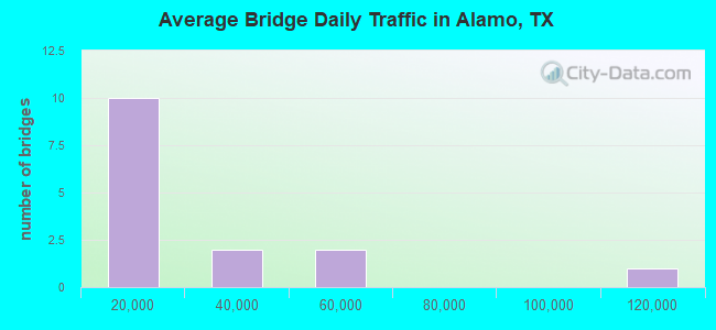
- 351,981Total average daily traffic
- 24,912Total average daily truck traffic
- National Bridge Inventory (NBI) Registered Bridges for Alamo
- No street view available for this location
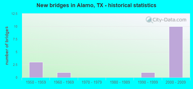
- New bridges - historical statistics
- 31950-1959
- 11960-1969
- 11990-1999
- 102000-2009
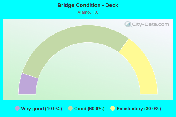
- Bridge Condition - Deck
- 10.0%Very good
- 60.0%Good
- 30.0%Satisfactory
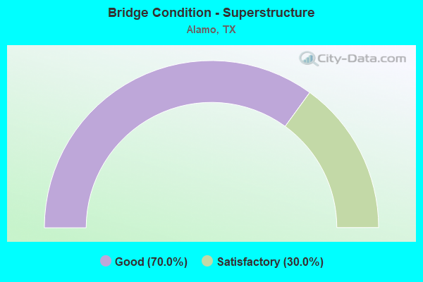
- Bridge Condition - Superstructure
- 70.0%Good
- 30.0%Satisfactory
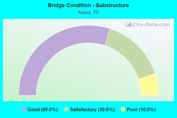
- Bridge Condition - Substructure
- 60.0%Good
- 30.0%Satisfactory
- 10.0%Poor
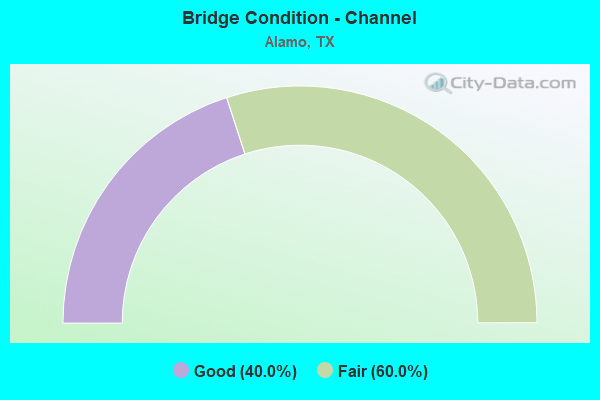
- Bridge Condition - Channel
- 40.0%Good
- 60.0%Fair
Find on map >> Show street view
Structure Number: 211090003918281, Location: 3.2 MI E OF US 281 (Lat: 26.193000, Lng: -98.133489), Route carried "on" structure: US 83, Year Built: 2002, Status: Open, Structure Length: 6.95m (22.80ft), Average Daily Traffic: 105,149 (year 2018), Truck Traffic: 9%, Average Future Daily Traffic: 90,000 (year 2033), Design Load: HS 20, Features Intersected: CESAR CHAVEZ ROAD
Minimum Vertical Clearance: 30+ m (98+ ft), Kilometerpoint: 49.307, Lanes on structure: 4, Lanes under structure: 6, Owner: State Highway Agency, Approaching Roadway Width: 20.4m (66.9ft), Material/Design: Prestressed concrete, Design/Construction: Stringer/Multi-beam, Number Of Spans In Main Unit: 1, Number Of Approach Spans: 2, Length of Maximum Span: 33.5m (109.9ft), Curb-To-Curb Width: 20.3m (66.6ft), Out-to-Out Width: 21.0m (68.9ft)
Condition: Deck: Good, Superstructure: Good, Substructure: Good, Operating Rating: 54.4 metric tons, Method Used To Determine Operating Rating: Assigned rating based on Load Factor Design (LFD) reported in metric tons, Inventory Rating: 32.7 metric tons, Method Used To Determine Inventory Rating: Assigned rating based on Load Factor Design (LFD) reported in metric tons, Structural Evaluation: Better than present minimum criteria, Deck Geometry: Equal to present minimum criteria, Underclear: Better than present minimum criteria, Approach Roadway Alignment: Equal to present desirable criteria, Designated Inspection Frequency: Every 24 months, Inspection Date: May 2021, Deck Structure Type: Concrete Precast Panels
Find on map >> Show street view
Structure Number: 211090003918283, Location: 3.9 MI E OF US 281 (Lat: 26.191342, Lng: -98.121553), Route carried "on" structure: US 83, Year Built: 2002, Status: Open, Structure Length: 6.95m (22.80ft), Average Daily Traffic: 43,450 (year 2011), Truck Traffic: 7%, Average Future Daily Traffic: 60,830 (year 2031), Design Load: HS 20, Features Intersected: FM 907 (ALAMO RD)
Minimum Vertical Clearance: 30+ m (98+ ft), Kilometerpoint: 50.519, Lanes on structure: 4, Lanes under structure: 8, Owner: State Highway Agency, Approaching Roadway Width: 20.4m (66.9ft), Material/Design: Prestressed concrete, Design/Construction: Stringer/Multi-beam, Number Of Spans In Main Unit: 1, Number Of Approach Spans: 2, Length of Maximum Span: 33.5m (109.9ft), Curb-To-Curb Width: 20.3m (66.6ft), Out-to-Out Width: 21.0m (68.9ft)
Condition: Deck: Good, Superstructure: Good, Substructure: Good, Operating Rating: 54.4 metric tons, Method Used To Determine Operating Rating: Assigned rating based on Load Factor Design (LFD) reported in metric tons, Inventory Rating: 32.7 metric tons, Method Used To Determine Inventory Rating: Assigned rating based on Load Factor Design (LFD) reported in metric tons, Structural Evaluation: Better than present minimum criteria, Deck Geometry: Equal to present minimum criteria, Underclear: Equal to present minimum criteria, Approach Roadway Alignment: Equal to present desirable criteria, Designated Inspection Frequency: Every 24 months, Inspection Date: April 2021, Deck Structure Type: Concrete Precast Panels
Find on map >> Show street view
Structure Number: 211090003918284, Location: 3.9 MI E OF US 281 (Lat: 26.191078, Lng: -98.122297), Route carried "on" structure: US 83, Year Built: 2002, Status: Open, Structure Length: 6.95m (22.80ft), Average Daily Traffic: 43,450 (year 2011), Truck Traffic: 7%, Average Future Daily Traffic: 60,830 (year 2031), Design Load: HS 20, Features Intersected: FM 907 (ALAMO RD)
Minimum Vertical Clearance: 30+ m (98+ ft), Kilometerpoint: 50.519, Lanes on structure: 4, Lanes under structure: 8, Owner: State Highway Agency, Approaching Roadway Width: 20.4m (66.9ft), Material/Design: Prestressed concrete, Design/Construction: Stringer/Multi-beam, Number Of Spans In Main Unit: 1, Number Of Approach Spans: 2, Length of Maximum Span: 33.5m (109.9ft), Curb-To-Curb Width: 20.3m (66.6ft), Out-to-Out Width: 21.0m (68.9ft)
Condition: Deck: Good, Superstructure: Good, Substructure: Good, Operating Rating: 54.4 metric tons, Method Used To Determine Operating Rating: Assigned rating based on Load Factor Design (LFD) reported in metric tons, Inventory Rating: 32.7 metric tons, Method Used To Determine Inventory Rating: Assigned rating based on Load Factor Design (LFD) reported in metric tons, Structural Evaluation: Better than present minimum criteria, Deck Geometry: Equal to present minimum criteria, Underclear: Equal to present minimum criteria, Approach Roadway Alignment: Equal to present desirable criteria, Designated Inspection Frequency: Every 24 months, Inspection Date: April 2021, Deck Structure Type: Concrete Precast Panels
Find on map >> Show street view
Structure Number: 211090003918285, Location: 4.65 MI E OF US 281 (Lat: 26.189683, Lng: -98.109619), Route carried "on" structure: US 83, Year Built: 2002, Status: Open, Structure Length: 6.95m (22.80ft), Average Daily Traffic: 35,990 (year 2011), Truck Traffic: 9%, Average Future Daily Traffic: 57,220 (year 2031), Design Load: HS 20, Features Intersected: TOWER RD
Minimum Vertical Clearance: 30+ m (98+ ft), Kilometerpoint: 51.719, Lanes on structure: 4, Lanes under structure: 6, Owner: State Highway Agency, Approaching Roadway Width: 20.4m (66.9ft), Material/Design: Prestressed concrete, Design/Construction: Stringer/Multi-beam, Number Of Spans In Main Unit: 1, Number Of Approach Spans: 2, Length of Maximum Span: 33.5m (109.9ft), Curb-To-Curb Width: 20.3m (66.6ft), Out-to-Out Width: 21.0m (68.9ft)
Condition: Deck: Good, Superstructure: Good, Substructure: Good, Operating Rating: 54.4 metric tons, Method Used To Determine Operating Rating: Assigned rating based on Load Factor Design (LFD) reported in metric tons, Inventory Rating: 32.7 metric tons, Method Used To Determine Inventory Rating: Assigned rating based on Load Factor Design (LFD) reported in metric tons, Structural Evaluation: Better than present minimum criteria, Deck Geometry: Equal to present minimum criteria, Underclear: Superior to present desirable criteria, Approach Roadway Alignment: Equal to present desirable criteria, Designated Inspection Frequency: Every 24 months, Inspection Date: April 2021, Deck Structure Type: Concrete Precast Panels
Find on map >> Show street view
Structure Number: 211090003918286, Location: 4.65 MI E OF US 281 (Lat: 26.189425, Lng: -98.110358), Route carried "on" structure: US 83, Year Built: 2002, Status: Open, Structure Length: 6.95m (22.80ft), Average Daily Traffic: 35,990 (year 2011), Truck Traffic: 9%, Average Future Daily Traffic: 57,220 (year 2031), Design Load: HS 20, Features Intersected: TOWER RD
Minimum Vertical Clearance: 30+ m (98+ ft), Kilometerpoint: 51.719, Lanes on structure: 4, Lanes under structure: 6, Owner: State Highway Agency, Approaching Roadway Width: 20.4m (66.9ft), Material/Design: Prestressed concrete, Design/Construction: Stringer/Multi-beam, Number Of Spans In Main Unit: 1, Number Of Approach Spans: 2, Length of Maximum Span: 33.5m (109.9ft), Curb-To-Curb Width: 20.3m (66.6ft), Out-to-Out Width: 21.0m (68.9ft)
Condition: Deck: Good, Superstructure: Good, Substructure: Good, Operating Rating: 54.4 metric tons, Method Used To Determine Operating Rating: Assigned rating based on Load Factor Design (LFD) reported in metric tons, Inventory Rating: 32.7 metric tons, Method Used To Determine Inventory Rating: Assigned rating based on Load Factor Design (LFD) reported in metric tons, Structural Evaluation: Better than present minimum criteria, Deck Geometry: Equal to present minimum criteria, Underclear: Better than present minimum criteria, Approach Roadway Alignment: Equal to present desirable criteria, Designated Inspection Frequency: Every 24 months, Inspection Date: April 2021, Deck Structure Type: Concrete Precast Panels
Find on map >> Show street view
Structure Number: 211090158601007, Location: 2.9 MI S OF BUS 83 (Lat: 26.141175, Lng: -98.130408), Route carried "on" structure: State highway 907, Year Built: 1996, Status: Open, Structure Length: 4.11m (13.48ft), Average Daily Traffic: 4,065 (year 2020), Truck Traffic: 5%, Average Future Daily Traffic: 5,160 (year 2033), Design Load: HS 20, Features Intersected: MAIN FLOODWAY PILOT CH
Minimum Vertical Clearance: 30+ m (98+ ft), Kilometerpoint: 22.661, Lanes on structure: 2, Owner: State Highway Agency, Approaching Roadway Width: 11.6m (38.1ft), Skew: 3 degrees, Material/Design: Prestressed concrete, Design/Construction: Box Beam or Girders - Multiple, Number Of Spans In Main Unit: 3, Length of Maximum Span: 13.7m (44.9ft), Curb-To-Curb Width: 12.1m (39.7ft), Out-to-Out Width: 12.9m (42.3ft)
Condition: Deck: Very good, Superstructure: Good, Substructure: Good, Channel: Good, Operating Rating: 54.4 metric tons, Method Used To Determine Operating Rating: Assigned rating based on Load Factor Design (LFD) reported in metric tons, Inventory Rating: 32.7 metric tons, Method Used To Determine Inventory Rating: Assigned rating based on Load Factor Design (LFD) reported in metric tons, Structural Evaluation: Better than present minimum criteria, Deck Geometry: Somewhat better than minimum adequacy, Waterway Adequacy: High priority of corrective action, Approach Roadway Alignment: Equal to present desirable criteria, Designated Inspection Frequency: Every 24 months, Inspection Date: April 2021, Deck Structure Type: Other, Wearing Surface/Protective System: Wearing Surface: Bituminous
Find on map >> Show street view
Structure Number: 211090AA0654001, Location: 1.0 MI E OF FM 907 (Lat: 26.112611, Lng: -98.118803), Route carried "on" structure: County highway , Year Built: 1950, Status: Open, Structure Length: 1.89m (6.20ft), Average Daily Traffic: 100 (year 2019), Average Future Daily Traffic: 75 (year 2032), Features Intersected: S FLOODWATER CHANNEL, Facility Carried by Structure: DICKER RD
Minimum Vertical Clearance: 30+ m (98+ ft), Kilometerpoint: 1.609, Lanes on structure: 2, Owner: County Highway Agency, Approaching Roadway Width: 4.9m (16.1ft), Material/Design: Concrete, Design/Construction: Slab, Number Of Spans In Main Unit: 3, Length of Maximum Span: 6.1m (20.0ft), Curb-To-Curb Width: 6.6m (21.7ft), Out-to-Out Width: 7.3m (24.0ft)
Condition: Deck: Satisfactory, Superstructure: Satisfactory, Substructure: Satisfactory, Channel: Fair, Operating Rating: 32.7 metric tons, Method Used To Determine Operating Rating: Field evaluation and documented engineering judgment, Inventory Rating: 24.5 metric tons, Method Used To Determine Inventory Rating: Field evaluation and documented engineering judgment, Structural Evaluation: Equal to present minimum criteria, Deck Geometry: Somewhat better than minimum adequacy, Waterway Adequacy: Better than present minimum criteria, Approach Roadway Alignment: Equal to present desirable criteria, Designated Inspection Frequency: Every 24 months, Inspection Date: April 2020, Deck Structure Type: Concrete Cast-file-Place
Find on map >> Show street view
Structure Number: 211090AA0655001, Location: 1.80 MI N OF JCT US 281 (Lat: 26.110078, Lng: -98.123592), Route carried "on" structure: County highway , Year Built: 1950, Status: Posted for load, Structure Length: 1.55m (5.09ft), Average Daily Traffic: 60 (year 2010), Average Future Daily Traffic: 90 (year 2032), Features Intersected: S FLOODWATER CHANNEL, Facility Carried by Structure: TOWER ROAD
Minimum Vertical Clearance: 30+ m (98+ ft), Kilometerpoint: 2.897, Lanes on structure: 2, Owner: County Highway Agency, Approaching Roadway Width: 4.9m (16.1ft), Material/Design: Concrete continuous, Design/Construction: Slab, Number Of Spans In Main Unit: 3, Length of Maximum Span: 5.5m (18.0ft), Curb-To-Curb Width: 6.6m (21.7ft), Out-to-Out Width: 7.3m (24.0ft)
Condition: Deck: Good, Superstructure: Good, Substructure: Poor, Channel: Fair, Operating Rating: 32.7 metric tons, Method Used To Determine Operating Rating: Field evaluation and documented engineering judgment, Inventory Rating: 24.5 metric tons, Method Used To Determine Inventory Rating: Field evaluation and documented engineering judgment, Structural Evaluation: Meets minimum limits, Deck Geometry: Somewhat better than minimum adequacy, Waterway Adequacy: Better than present minimum criteria, Approach Roadway Alignment: Equal to present desirable criteria, Bridge Posting: Required (Relationship of Operating Rating to Maximum Legal Load: 20.0 - 29.9% below), Designated Inspection Frequency: Every 24 months, Inspection Date: April 2020, Deck Structure Type: Concrete Cast-file-Place
Find on map >> Show street view
Structure Number: 211090AA0934001, Location: 0.03 MI E OF FM 1423 (Lat: 26.198311, Lng: -98.084144), Route carried "on" structure: County highway , Year Built: 1962, Status: Open, Structure Length: 0.79m (2.59ft), Average Daily Traffic: 893 (year 2019), Truck Traffic: 2%, Average Future Daily Traffic: 200 (year 2032), Features Intersected: DONNA EAST MAIN CANAL, Facility Carried by Structure: CO RD 934
Minimum Vertical Clearance: 30+ m (98+ ft), Kilometerpoint: 0.048, Lanes on structure: 2, Owner: County Highway Agency, Approaching Roadway Width: 4.9m (16.1ft), Material/Design: Concrete, Design/Construction: Slab, Number Of Spans In Main Unit: 2, Length of Maximum Span: 3.7m (12.1ft), Curb-To-Curb Width: 5.5m (18.0ft), Out-to-Out Width: 6.1m (20.0ft)
Condition: Deck: Satisfactory, Superstructure: Satisfactory, Substructure: Satisfactory, Channel: Good, Operating Rating: 32.7 metric tons, Method Used To Determine Operating Rating: Field evaluation and documented engineering judgment, Inventory Rating: 24.5 metric tons, Method Used To Determine Inventory Rating: Field evaluation and documented engineering judgment, Structural Evaluation: Equal to present minimum criteria, Deck Geometry: High priority of replacement, Waterway Adequacy: Better than present minimum criteria, Approach Roadway Alignment: Equal to present minimum criteria, Length Of Structure Improvement: 0.79m (2.59ft), Designated Inspection Frequency: Every 24 months, Inspection Date: April 2020, Bridge Improvement Cost: $1,000, Total Project Cost: $1,000, Deck Structure Type: Concrete Cast-file-Place
Find on map >> Show street view
Structure Number: 211090AA1013001, Location: 0.50 MI E OF TOWER ROAD (Lat: 26.176703, Lng: -98.104028), Route carried "on" structure: County highway , Year Built: 1950, Status: Open, Structure Length: 1.34m (4.40ft), Average Daily Traffic: 2,034 (year 2019), Truck Traffic: 2%, Average Future Daily Traffic: 400 (year 2032), Features Intersected: DRAINAGE DITCH, Facility Carried by Structure: EAST CROCKETT ST
Minimum Vertical Clearance: 30+ m (98+ ft), Kilometerpoint: 0.805, Lanes on structure: 2, Owner: County Highway Agency, Approaching Roadway Width: 5.5m (18.0ft), Material/Design: Concrete, Design/Construction: Slab, Number Of Spans In Main Unit: 3, Length of Maximum Span: 4.3m (14.1ft), Curb-To-Curb Width: 6.7m (22.0ft), Out-to-Out Width: 7.3m (24.0ft)
Condition: Deck: Satisfactory, Superstructure: Satisfactory, Substructure: Satisfactory, Channel: Fair, Operating Rating: 32.7 metric tons, Method Used To Determine Operating Rating: Field evaluation and documented engineering judgment, Inventory Rating: 24.5 metric tons, Method Used To Determine Inventory Rating: Field evaluation and documented engineering judgment, Structural Evaluation: Equal to present minimum criteria, Deck Geometry: High priority of replacement, Waterway Adequacy: Meets minimum limits, Approach Roadway Alignment: Equal to present desirable criteria, Designated Inspection Frequency: Every 24 months, Inspection Date: April 2020, Deck Structure Type: Concrete Cast-file-Place
Find on map >> Show street view
Structure Number: 211090003918281, Location: 3.2 MI E OF US 281 (Lat: 26.193000, Lng: -98.133489), Route carried "under" structure: City street , Year Built: 2002, Structure Length: 0. m, Average Daily Traffic: 9,360 (year 2009), Truck Traffic: 1%, Features Intersected: CESAR CHAVEZ ROAD, Facility Carried by Structure: US 83 WB
Minimum Vertical Clearance: 5.03m (16.50ft), Lanes on structure: 4, Lanes under structure: 6, Material/Design: Prestressed concrete, Design/Construction: Stringer/Multi-beam, Length of Maximum Span: 33.5m (109.9ft)
Find on map >> Show street view
Structure Number: 211090003918283, Location: 3.9 MI E OF US 281 (Lat: 26.191342, Lng: -98.121553), Route carried "under" structure: State highway 907, Year Built: 2002, Structure Length: 0. m, Average Daily Traffic: 18,470 (year 2013), Truck Traffic: 5%, Features Intersected: FM 907 (ALAMO RD), Facility Carried by Structure: US 83 WB
Minimum Vertical Clearance: 5.05m (16.57ft), Kilometerpoint: 17.114, Lanes on structure: 4, Lanes under structure: 8, Material/Design: Prestressed concrete, Design/Construction: Stringer/Multi-beam, Length of Maximum Span: 33.5m (109.9ft)
Find on map >> Show street view
Structure Number: 211090003918284, Location: 3.9 MI E OF US 281 (Lat: 26.191078, Lng: -98.122297), Route carried "under" structure: State highway 907, Year Built: 2002, Structure Length: 0. m, Average Daily Traffic: 18,470 (year 2013), Truck Traffic: 5%, Features Intersected: FM 907 (ALAMO RD), Facility Carried by Structure: US 83 EB
Minimum Vertical Clearance: 5.11m (16.77ft), Kilometerpoint: 17.128, Lanes on structure: 4, Lanes under structure: 8, Material/Design: Prestressed concrete, Design/Construction: Stringer/Multi-beam, Length of Maximum Span: 33.5m (109.9ft)
Find on map >> Show street view
Structure Number: 211090003918285, Location: 4.65 MI E OF US 281 (Lat: 26.189683, Lng: -98.109619), Route carried "under" structure: City street , Year Built: 2002, Structure Length: 0. m, Average Daily Traffic: 17,250 (year 2009), Truck Traffic: 2%, Features Intersected: TOWER RD, Facility Carried by Structure: US 83 WB
Minimum Vertical Clearance: 5.49m (18.01ft), Kilometerpoint: 0.000, Lanes on structure: 4, Lanes under structure: 6, Material/Design: Prestressed concrete, Design/Construction: Stringer/Multi-beam, Length of Maximum Span: 33.5m (109.9ft)
Find on map >> Show street view
Structure Number: 211090003918286, Location: 4.65 MI E OF US 281 (Lat: 26.189425, Lng: -98.110358), Route carried "under" structure: City street , Year Built: 2002, Structure Length: 0. m, Average Daily Traffic: 17,250 (year 2009), Truck Traffic: 2%, Features Intersected: TOWER RD, Facility Carried by Structure: US 83 EB
Minimum Vertical Clearance: 5.08m (16.67ft), Kilometerpoint: 0.000, Lanes on structure: 4, Lanes under structure: 6, Material/Design: Prestressed concrete, Design/Construction: Stringer/Multi-beam, Length of Maximum Span: 33.5m (109.9ft)