Bridge Statistics for Alexandria, Alabama (AL)
Condition, Traffic, Stress, Structural Evaluation, Project Costs
- National Bridge Inventory (NBI) Statistics
- 26Number of bridges
- 285ft / 86.7mTotal length
- $29,759,000Total costs
- 148,799Total average daily traffic
- 10,680Total average daily truck traffic
- National Bridge Inventory (NBI) Registered Bridges for Alexandria
- No street view available for this location
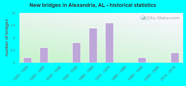
- New bridges - historical statistics
- 11920-1929
- 31930-1939
- 41950-1959
- 71960-1969
- 81970-1979
- 11990-1999
- 22010-2019

- Reconstructed bridges - Historical Statistics
- 11970-1979
- 11980-1989


- Bridge Condition - Deck
- 6.3%Excellent
- 6.3%Very good
- 18.8%Good
- 50.0%Satisfactory
- 18.8%Fair

- Bridge Condition - Superstructure
- 6.3%Excellent
- 6.3%Very good
- 31.3%Good
- 18.8%Satisfactory
- 37.5%Fair

- Bridge Condition - Substructure
- 6.3%Excellent
- 12.5%Very good
- 25.0%Good
- 25.0%Satisfactory
- 25.0%Fair
- 6.3%Poor

- Bridge Condition - Channel
- 4.5%Excellent
- 4.5%Very good
- 36.4%Good
- 40.9%Satisfactory
- 13.6%Fair

- Bridge Condition - Culverts
- 11.1%Very good
- 11.1%Good
- 66.7%Satisfactory
- 11.1%Fair
Find on map >> Show street view
Structure Number: 622, Location: 4.5 MI N OF MILLPORT (Lat: 33.621933, Lng: -88.072633), Route carried "on" structure: State highway 17, Year Built: 1929, Status: Open, Structure Length: 0.67m (2.20ft), Average Daily Traffic: 1,330 (year 2020), Truck Traffic: 22%, Average Future Daily Traffic: 1,715 (year 2040), Design Load: H 15, Features Intersected: Mud Creek
Minimum Vertical Clearance: 30+ m (98+ ft), Kilometerpoint: 375.450, Lanes on structure: 2, Base Highway Network: Yes, Owner: State Highway Agency, Approaching Roadway Width: 8.5m (27.9ft), Skew: 1 degrees, Material/Design: Concrete, Design/Construction: Culvert, Number Of Spans In Main Unit: 2, Length of Maximum Span: 3.2m (10.5ft)
Condition: Channel: Satisfactory, Culverts: Satisfactory, Operating Rating: 78.7 metric tons, Method Used To Determine Operating Rating: Load Factor (LF), Inventory Rating: 47.3 metric tons, Method Used To Determine Inventory Rating: Load Factor (LF), Structural Evaluation: Equal to present minimum criteria, Waterway Adequacy: Equal to present minimum criteria, Approach Roadway Alignment: Equal to present minimum criteria, Length Of Structure Improvement: 1.30m (4.27ft), Designated Inspection Frequency: Every 24 months, Inspection Date: April 2020, Bridge Improvement Cost: $353,000, Roadway Improvement Cost: $35,000, Total Project Cost: $388,000 ( Estimate for 2022)
Find on map >> Show street view
Structure Number: 1207, Location: ALEX-WELL RD (Lat: 33.770403, Lng: -85.882036), Route carried "on" structure: County highway 13, Year Built: 1935, Status: Posted for load, Structure Length: 1.22m (4.00ft), Average Daily Traffic: 2,573 (year 2015), Truck Traffic: 1%, Average Future Daily Traffic: 4,221 (year 2040), Features Intersected: ALEXANDRIA CREEK, Facility Carried by Structure: ALEX-WELL. RD.
Minimum Vertical Clearance: 30+ m (98+ ft), Kilometerpoint: 0.010, Lanes on structure: 2, Owner: County Highway Agency, Approaching Roadway Width: 6.7m (22.0ft), Skew: 1 degrees, Material/Design: Concrete, Design/Construction: Slab, Number Of Spans In Main Unit: 2, Length of Maximum Span: 3.0m (9.8ft), Curb-To-Curb Width: 5.8m (19.0ft), Out-to-Out Width: 6.1m (20.0ft)
Condition: Deck: Fair, Superstructure: Fair, Substructure: Poor, Channel: Good, Operating Rating: 16.3 metric tons, Method Used To Determine Operating Rating: Field evaluation and documented engineering judgment, Inventory Rating: 16.3 metric tons, Method Used To Determine Inventory Rating: Field evaluation and documented engineering judgment, Structural Evaluation: Meets minimum limits, Deck Geometry: High priority of replacement, Waterway Adequacy: Superior to present desirable criteria, Approach Roadway Alignment: Equal to present desirable criteria, Bridge Posting: Required (Relationship of Operating Rating to Maximum Legal Load: > 39.9% below), Length Of Structure Improvement: 1.89m (6.20ft), Designated Inspection Frequency: Every 24 months, Other Special Inspection Frequency: Every 12 months, Inspection Date: December 2020, Other Special Inspection Date: December 2021, Bridge Improvement Cost: $259,000, Roadway Improvement Cost: $26,000, Total Project Cost: $285,000 ( Estimate for 2022), Deck Structure Type: Concrete Cast-file-Place, Wearing Surface/Protective System: Wearing Surface: Bituminous
Find on map >> Show street view
Structure Number: 1927, Location: MT. VIEW RD. (Lat: 33.800156, Lng: -85.921475), Route carried "on" structure: County highway 17, Year Built: 1939, Status: Posted for load, Structure Length: 5.85m (19.19ft), Average Daily Traffic: 275 (year 2020), Truck Traffic: 1%, Average Future Daily Traffic: 417 (year 2041), Features Intersected: TALLAHATCHEE CREEK, Facility Carried by Structure: Mt. View Rd.
Minimum Vertical Clearance: 30+ m (98+ ft), Kilometerpoint: 0.010, Lanes on structure: 2, Owner: County Highway Agency, Approaching Roadway Width: 7.9m (25.9ft), Material/Design: Steel, Design/Construction: Stringer/Multi-beam, Number Of Spans In Main Unit: 7, Length of Maximum Span: 8.5m (27.9ft), Curb-To-Curb Width: 6.1m (20.0ft), Out-to-Out Width: 6.5m (21.3ft)
Condition: Deck: Fair, Superstructure: Fair, Substructure: Fair, Channel: Fair, Operating Rating: 26.7 metric tons, Method Used To Determine Operating Rating: Allowable Stress (AS), Inventory Rating: 16.5 metric tons, Method Used To Determine Inventory Rating: Allowable Stress (AS), Structural Evaluation: Somewhat better than minimum adequacy, Deck Geometry: Meets minimum limits, Waterway Adequacy: Somewhat better than minimum adequacy, Approach Roadway Alignment: Equal to present minimum criteria, Bridge Posting: Required (Relationship of Operating Rating to Maximum Legal Load: > 39.9% below), Length Of Structure Improvement: 6.89m (22.60ft), Designated Inspection Frequency: Every 24 months, Other Special Inspection Frequency: Every 12 months, Inspection Date: May 2021, Other Special Inspection Date: May 2021, Bridge Improvement Cost: $992,000, Roadway Improvement Cost: $99,000, Total Project Cost: $1,091,000 ( Estimate for 2022), Deck Structure Type: Concrete Cast-file-Place
Find on map >> Show street view
Structure Number: 386, Location: CIRCLE TO US 431 NORTH (Lat: 31.285514, Lng: -85.381181), Route carried "on" structure: County highway 105, Year Built: 1950, Status: Open, Structure Length: 0.61m (2.00ft), Average Daily Traffic: 1,785 (year 2005), Truck Traffic: 7%, Average Future Daily Traffic: 2,499 (year 2033), Features Intersected: HODGES BRANCH, Facility Carried by Structure: HEADLAND AVE
Minimum Vertical Clearance: 30+ m (98+ ft), Kilometerpoint: 0.010, Lanes on structure: 2, Owner: County Highway Agency, Approaching Roadway Width: 9.8m (32.2ft), Material/Design: Concrete, Design/Construction: Culvert, Number Of Spans In Main Unit: 1, Length of Maximum Span: 6.1m (20.0ft)
Condition: Channel: Satisfactory, Culverts: Satisfactory, Operating Rating: 32.7 metric tons, Method Used To Determine Operating Rating: Field evaluation and documented engineering judgment, Inventory Rating: 23.6 metric tons, Method Used To Determine Inventory Rating: Field evaluation and documented engineering judgment, Structural Evaluation: Equal to present minimum criteria, Waterway Adequacy: Equal to present minimum criteria, Approach Roadway Alignment: Better than present minimum criteria, Length Of Structure Improvement: 1.22m (4.00ft), Designated Inspection Frequency: Every 24 months, Inspection Date: October 2021, Bridge Improvement Cost: $169,000, Roadway Improvement Cost: $17,000, Total Project Cost: $186,000 ( Estimate for 2022), Wearing Surface/Protective System: Wearing Surface: Bituminous
Find on map >> Show street view
Structure Number: 6218, Location: CO RD 49 TO CO RD 43 (Lat: 31.122064, Lng: -85.368864), Route carried "on" structure: County highway 18, Year Built: 1958, Status: Open, Structure Length: 1.30m (4.27ft), Average Daily Traffic: 198 (year 1992), Truck Traffic: 7%, Average Future Daily Traffic: 775 (year 2033), Features Intersected: DOUBLE BRIDGE CREEK
Minimum Vertical Clearance: 30+ m (98+ ft), Kilometerpoint: 0.010, Lanes on structure: 2, Owner: County Highway Agency, Approaching Roadway Width: 9.1m (29.9ft), Material/Design: Concrete, Design/Construction: Culvert, Number Of Spans In Main Unit: 4, Length of Maximum Span: 3.0m (9.8ft)
Condition: Channel: Good, Culverts: Good, Operating Rating: 73.3 metric tons, Method Used To Determine Operating Rating: Load Factor (LF), Inventory Rating: 44.0 metric tons, Method Used To Determine Inventory Rating: Load Factor (LF), Structural Evaluation: Better than present minimum criteria, Waterway Adequacy: Equal to present minimum criteria, Approach Roadway Alignment: Equal to present desirable criteria, Length Of Structure Improvement: 1.97m (6.46ft), Designated Inspection Frequency: Every 24 months, Inspection Date: June 2021, Bridge Improvement Cost: $534,000, Roadway Improvement Cost: $53,000, Total Project Cost: $587,000 ( Estimate for 2022), Wearing Surface/Protective System: Wearing Surface: Bituminous
Find on map >> Show street view
Structure Number: 6221, Location: 4 MI NW OF BLOUNTSVILLE (Lat: 34.116481, Lng: -86.634225), Route carried "on" structure: County highway 51, Year Built: 1958, Status: Posted for load, Structure Length: 9.97m (32.71ft), Average Daily Traffic: 409 (year 2021), Truck Traffic: 4%, Average Future Daily Traffic: 608 (year 2041), Design Load: H 15, Features Intersected: BLACK WARRIOR RIVER
Minimum Vertical Clearance: 30+ m (98+ ft), Kilometerpoint: 0.010, Lanes on structure: 2, Owner: County Highway Agency, Approaching Roadway Width: 7.9m (25.9ft), Material/Design: Concrete continuous, Design/Construction: Tee Beam, Number Of Spans In Main Unit: 3, Number Of Approach Spans: 4, Length of Maximum Span: 21.3m (69.9ft), Curb-To-Curb Width: 6.7m (22.0ft), Out-to-Out Width: 7.7m (25.3ft)
Condition: Deck: Satisfactory, Superstructure: Fair, Substructure: Fair, Channel: Fair, Operating Rating: 39.0 metric tons, Method Used To Determine Operating Rating: Allowable Stress (AS), Inventory Rating: 23.6 metric tons, Method Used To Determine Inventory Rating: Allowable Stress (AS), Structural Evaluation: Somewhat better than minimum adequacy, Deck Geometry: Meets minimum limits, Waterway Adequacy: Superior to present desirable criteria, Approach Roadway Alignment: Equal to present minimum criteria, Bridge Posting: Required (Relationship of Operating Rating to Maximum Legal Load: 10.0 - 19.9% below), Length Of Structure Improvement: 10.90m (35.76ft), Designated Inspection Frequency: Every 24 months, Other Special Inspection Frequency: Every 12 months, Inspection Date: June 2021, Other Special Inspection Date: June 2021, Bridge Improvement Cost: $1,869,000, Roadway Improvement Cost: $187,000, Total Project Cost: $2,056,000 ( Estimate for 2022), Deck Structure Type: Concrete Cast-file-Place
Find on map >> Show street view
Structure Number: 8019, Location: 7 MI EAST JCT SR 77 (Lat: 33.784694, Lng: -85.927861), Route carried "on" structure: State highway 144, Year Built: 1963, Status: Open, Structure Length: 1.91m (6.27ft), Average Daily Traffic: 7,447 (year 2020), Truck Traffic: 7%, Average Future Daily Traffic: 10,246 (year 2040), Design Load: H 20, Features Intersected: BATTLE CREEK
Minimum Vertical Clearance: 30+ m (98+ ft), Kilometerpoint: 40.123, Lanes on structure: 2, Owner: State Highway Agency, Approaching Roadway Width: 8.5m (27.9ft), Material/Design: Concrete, Design/Construction: Culvert, Number Of Spans In Main Unit: 5, Length of Maximum Span: 3.7m (12.1ft)
Condition: Channel: Satisfactory, Culverts: Satisfactory, Operating Rating: 46.6 metric tons, Method Used To Determine Operating Rating: Load Factor (LF), Inventory Rating: 27.9 metric tons, Method Used To Determine Inventory Rating: Load Factor (LF), Structural Evaluation: Equal to present minimum criteria, Waterway Adequacy: Somewhat better than minimum adequacy, Approach Roadway Alignment: Equal to present desirable criteria, Length Of Structure Improvement: 2.65m (8.69ft), Designated Inspection Frequency: Every 24 months, Inspection Date: September 2021, Bridge Improvement Cost: $886,000, Roadway Improvement Cost: $89,000, Total Project Cost: $975,000 ( Estimate for 2022)
Find on map >> Show street view
Structure Number: 802, Location: 8 MI EAST JCT SR 77 (Lat: 33.782389, Lng: -85.905625), Route carried "on" structure: State highway 144, Year Built: 1963, Status: Open, Structure Length: 2.56m (8.40ft), Average Daily Traffic: 9,710 (year 2020), Truck Traffic: 7%, Average Future Daily Traffic: 13,594 (year 2040), Design Load: HS 20, Features Intersected: LITTLE ALEXANDER CREEK
Minimum Vertical Clearance: 30+ m (98+ ft), Kilometerpoint: 42.215, Lanes on structure: 2, Owner: State Highway Agency, Approaching Roadway Width: 8.5m (27.9ft), Skew: 3 degrees, Material/Design: Concrete, Design/Construction: Culvert, Number Of Spans In Main Unit: 5, Length of Maximum Span: 4.9m (16.1ft)
Condition: Channel: Fair, Culverts: Fair, Operating Rating: 43.0 metric tons, Method Used To Determine Operating Rating: Load Factor (LF), Inventory Rating: 25.8 metric tons, Method Used To Determine Inventory Rating: Load Factor (LF), Structural Evaluation: Somewhat better than minimum adequacy, Waterway Adequacy: Equal to present minimum criteria, Approach Roadway Alignment: Equal to present desirable criteria, Length Of Structure Improvement: 3.45m (11.32ft), Designated Inspection Frequency: Every 24 months, Inspection Date: September 2021, Bridge Improvement Cost: $1,455,000, Roadway Improvement Cost: $146,000, Total Project Cost: $1,601,000 ( Estimate for 2022)
Find on map >> Show street view
Structure Number: 9673, Location: 6.2 MI N ALA 14 (Lat: 32.958333, Lng: -87.965000), Route carried "on" structure: County highway 23, Year Built: 1968, Status: Open, Structure Length: 4.05m (13.29ft), Average Daily Traffic: 395 (year 1995), Truck Traffic: 38%, Average Future Daily Traffic: 450 (year 2031), Design Load: H 15, Features Intersected: MURPHY CREEK, Facility Carried by Structure: CO RD 181
Minimum Vertical Clearance: 30+ m (98+ ft), Kilometerpoint: 0.010, Lanes on structure: 2, Owner: County Highway Agency, Approaching Roadway Width: 7.3m (24.0ft), Material/Design: Concrete, Design/Construction: Channel Beam, Number Of Spans In Main Unit: 7, Length of Maximum Span: 5.8m (19.0ft), Curb-To-Curb Width: 7.3m (24.0ft), Out-to-Out Width: 7.9m (25.9ft)
Condition: Deck: Good, Superstructure: Good, Substructure: Satisfactory, Channel: Satisfactory, Operating Rating: 57.9 metric tons, Method Used To Determine Operating Rating: Load Factor (LF), Inventory Rating: 38.0 metric tons, Method Used To Determine Inventory Rating: Load Factor (LF), Structural Evaluation: Equal to present minimum criteria, Deck Geometry: Somewhat better than minimum adequacy, Waterway Adequacy: Equal to present minimum criteria, Approach Roadway Alignment: Somewhat better than minimum adequacy, Length Of Structure Improvement: 5.01m (16.44ft), Designated Inspection Frequency: Every 24 months, Inspection Date: August 2020, Bridge Improvement Cost: $859,000, Roadway Improvement Cost: $86,000, Total Project Cost: $945,000 ( Estimate for 2022), Deck Structure Type: Concrete Precast Panels
Find on map >> Show street view
Structure Number: 9954, Location: 0.5 MI S JCT SR 144 (Lat: 33.771722, Lng: -85.893611), Route carried "on" structure: US 431, Year Built: 1969, Status: Open, Structure Length: 1.14m (3.74ft), Average Daily Traffic: 21,223 (year 2020), Truck Traffic: 8%, Average Future Daily Traffic: 29,712 (year 2040), Design Load: HS 20, Features Intersected: ALEXANDRIA CREEK
Minimum Vertical Clearance: 30+ m (98+ ft), Kilometerpoint: 385.518, Lanes on structure: 4, Base Highway Network: Yes, Owner: State Highway Agency, Approaching Roadway Width: 22.7m (74.5ft), Skew: 10 degrees, Material/Design: Concrete, Design/Construction: Culvert, Number Of Spans In Main Unit: 3, Length of Maximum Span: 3.7m (12.1ft)
Condition: Channel: Satisfactory, Culverts: Satisfactory, Operating Rating: 45.9 metric tons, Method Used To Determine Operating Rating: Load Factor (LF), Inventory Rating: 27.6 metric tons, Method Used To Determine Inventory Rating: Load Factor (LF), Structural Evaluation: Equal to present minimum criteria, Waterway Adequacy: Equal to present minimum criteria, Approach Roadway Alignment: Equal to present desirable criteria, Length Of Structure Improvement: 1.81m (5.94ft), Designated Inspection Frequency: Every 24 months, Inspection Date: August 2021, Bridge Improvement Cost: $1,306,000, Roadway Improvement Cost: $131,000, Total Project Cost: $1,437,000 ( Estimate for 2022)
Find on map >> Show street view
Structure Number: 9955, Location: 0.5 MI N JCT SR144 (Lat: 33.786761, Lng: -85.897483), Route carried "on" structure: US 431, Year Built: 1969, Status: Open, Structure Length: 0.72m (2.36ft), Average Daily Traffic: 21,879 (year 2019), Truck Traffic: 8%, Average Future Daily Traffic: 30,631 (year 2039), Design Load: HS 20, Features Intersected: BOYD SPRING BRANCH
Minimum Vertical Clearance: 30+ m (98+ ft), Kilometerpoint: 387.256, Lanes on structure: 4, Base Highway Network: Yes, Owner: State Highway Agency, Approaching Roadway Width: 22.7m (74.5ft), Skew: 14 degrees, Material/Design: Concrete, Design/Construction: Culvert, Number Of Spans In Main Unit: 2, Length of Maximum Span: 3.5m (11.5ft)
Condition: Channel: Good, Culverts: Satisfactory, Operating Rating: 51.6 metric tons, Method Used To Determine Operating Rating: Load Factor (LF), Inventory Rating: 30.9 metric tons, Method Used To Determine Inventory Rating: Load Factor (LF), Structural Evaluation: Equal to present minimum criteria, Waterway Adequacy: Equal to present minimum criteria, Approach Roadway Alignment: Equal to present desirable criteria, Length Of Structure Improvement: 1.37m (4.49ft), Designated Inspection Frequency: Every 24 months, Inspection Date: July 2021, Bridge Improvement Cost: $1,435,000, Roadway Improvement Cost: $144,000, Total Project Cost: $1,579,000 ( Estimate for 2022)
Find on map >> Show street view
Structure Number: 997, Location: US 31 * 3RD AVE SO (Lat: 33.513611, Lng: -86.793889), Route carried "on" structure: US 31, Year Built: 1969, Status: Open, Structure Length: 6.25m (20.51ft), Average Daily Traffic: 36,875 (year 2021), Truck Traffic: 3%, Average Future Daily Traffic: 47,368 (year 2041), Design Load: HS 20, Features Intersected: AL - 4 * 3RD AVE SO, Facility Carried by Structure: AL - 3 NORTH
Minimum Vertical Clearance: 30+ m (98+ ft), Kilometerpoint: 441.287, Lanes on structure: 3, Lanes under structure: 4, Owner: State Highway Agency, Approaching Roadway Width: 16.5m (54.1ft), Material/Design: Concrete continuous, Design/Construction: Tee Beam, Number Of Spans In Main Unit: 3, Length of Maximum Span: 23.8m (78.1ft), Curb-To-Curb Width: 16.3m (53.5ft), Out-to-Out Width: 16.8m (55.1ft)
Condition: Deck: Satisfactory, Superstructure: Satisfactory, Substructure: Satisfactory, Operating Rating: 57.4 metric tons, Method Used To Determine Operating Rating: Load Factor (LF), Inventory Rating: 35.7 metric tons, Method Used To Determine Inventory Rating: Load Factor (LF), Structural Evaluation: Equal to present minimum criteria, Deck Geometry: Better than present minimum criteria, Underclear: High priority of corrective action, Approach Roadway Alignment: Better than present minimum criteria, Length Of Structure Improvement: 7.29m (23.92ft), Designated Inspection Frequency: Every 24 months, Inspection Date: Febuary 2021, Bridge Improvement Cost: $2,749,000, Roadway Improvement Cost: $275,000, Total Project Cost: $3,024,000 ( Estimate for 2022), Deck Structure Type: Concrete Cast-file-Place
Find on map >> Show street view
Structure Number: 10247, Location: CORONA (Lat: 33.707333, Lng: -87.478889), Route carried "on" structure: County highway , Year Built: 1970, Status: Posted for load, Structure Length: 1.28m (4.20ft), Average Daily Traffic: 110 (year 1991), Truck Traffic: 5%, Average Future Daily Traffic: 250 (year 2031), Design Load: H 15, Features Intersected: FROST CREEK, Facility Carried by Structure: GIBSON HILL ROAD
Minimum Vertical Clearance: 30+ m (98+ ft), Kilometerpoint: 0.010, Lanes on structure: 2, Owner: County Highway Agency, Approaching Roadway Width: 4.9m (16.1ft), Material/Design: Steel, Design/Construction: Stringer/Multi-beam, Number Of Spans In Main Unit: 3, Length of Maximum Span: 4.9m (16.1ft), Curb-To-Curb Width: 6.1m (20.0ft), Out-to-Out Width: 6.1m (20.0ft)
Condition: Deck: Satisfactory, Superstructure: Fair, Substructure: Fair, Channel: Good, Operating Rating: 11.8 metric tons, Method Used To Determine Operating Rating: Allowable Stress (AS), Inventory Rating: 9.1 metric tons, Method Used To Determine Inventory Rating: Allowable Stress (AS), Structural Evaluation: High priority of replacement, Deck Geometry: Meets minimum limits, Waterway Adequacy: Better than present minimum criteria, Approach Roadway Alignment: Equal to present minimum criteria, Bridge Posting: Required (Relationship of Operating Rating to Maximum Legal Load: > 39.9% below), Length Of Structure Improvement: 1.95m (6.40ft), Designated Inspection Frequency: Every 24 months, Critical Feature Inspection Frequency: Every 24 months, Other Special Inspection Frequency: Every 12 months, Inspection Date: December 2021, Critical Feature Inspection Date: December 2021, Other Special Inspection Date: December 2021, Bridge Improvement Cost: $268,000, Roadway Improvement Cost: $27,000, Total Project Cost: $295,000 ( Estimate for 2022), Deck Structure Type: Corrugated Steel, Wearing Surface/Protective System: Wearing Surface: Gravel
Find on map >> Show street view
Structure Number: 10249, Location: 2 MILES N HWY 18 (Lat: 33.733333, Lng: -87.533333), Route carried "on" structure: County highway , Year Built: 1970, Status: Open, Structure Length: 1.22m (4.00ft), Average Daily Traffic: 60 (year 1991), Average Future Daily Traffic: 150 (year 2031), Design Load: H 15, Features Intersected: PENDLEY CREEK, Facility Carried by Structure: PENDLEY CREEK RD
Minimum Vertical Clearance: 30+ m (98+ ft), Kilometerpoint: 0.010, Lanes on structure: 10, Owner: County Highway Agency, Approaching Roadway Width: 3.7m (12.1ft), Material/Design: Steel, Design/Construction: Stringer/Multi-beam, Number Of Spans In Main Unit: 2, Length of Maximum Span: 6.1m (20.0ft), Curb-To-Curb Width: 3.7m (12.1ft), Out-to-Out Width: 3.7m (12.1ft)
Condition: Deck: Satisfactory, Superstructure: Satisfactory, Substructure: Good, Channel: Good, Operating Rating: 49.5 metric tons, Method Used To Determine Operating Rating: Load Factor (LF), Inventory Rating: 29.7 metric tons, Method Used To Determine Inventory Rating: Load Factor (LF), Structural Evaluation: Equal to present minimum criteria, Deck Geometry: High priority of replacement, Waterway Adequacy: Equal to present desirable criteria, Approach Roadway Alignment: Equal to present minimum criteria, Length Of Structure Improvement: 1.89m (6.20ft), Designated Inspection Frequency: Every 24 months, Critical Feature Inspection Frequency: Every 24 months, Inspection Date: December 2021, Critical Feature Inspection Date: December 2021, Bridge Improvement Cost: $156,000, Roadway Improvement Cost: $16,000, Total Project Cost: $172,000 ( Estimate for 2022), Deck Structure Type: Concrete Cast-file-Place
Find on map >> Show street view
Structure Number: 1025, Location: 2 MILES S JASPER (Lat: 33.801667, Lng: -87.290000), Route carried "on" structure: County highway , Year Built: 1970, Status: Posted for load, Structure Length: 1.83m (6.00ft), Average Daily Traffic: 40 (year 2009), Average Future Daily Traffic: 112 (year 2032), Design Load: H 15, Features Intersected: CANE CREEK, Facility Carried by Structure: CALUMET ROAD
Minimum Vertical Clearance: 30+ m (98+ ft), Kilometerpoint: 0.010, Lanes on structure: 1, Owner: County Highway Agency, Approaching Roadway Width: 4.9m (16.1ft), Material/Design: Steel, Design/Construction: Stringer/Multi-beam, Number Of Spans In Main Unit: 2, Length of Maximum Span: 9.1m (29.9ft), Curb-To-Curb Width: 3.7m (12.1ft), Out-to-Out Width: 3.7m (12.1ft)
Condition: Deck: Satisfactory, Superstructure: Fair, Substructure: Satisfactory, Channel: Satisfactory, Operating Rating: 19.5 metric tons, Method Used To Determine Operating Rating: Load Factor (LF), Inventory Rating: 11.7 metric tons, Method Used To Determine Inventory Rating: Load Factor (LF), Structural Evaluation: Meets minimum limits, Deck Geometry: Meets minimum limits, Waterway Adequacy: Equal to present desirable criteria, Approach Roadway Alignment: Meets minimum limits, Bridge Posting: Required (Relationship of Operating Rating to Maximum Legal Load: > 39.9% below), Length Of Structure Improvement: 2.54m (8.33ft), Designated Inspection Frequency: Every 24 months, Other Special Inspection Frequency: Every 12 months, Inspection Date: January 2022, Other Special Inspection Date: January 2022, Bridge Improvement Cost: $209,000, Roadway Improvement Cost: $21,000, Total Project Cost: $230,000 ( Estimate for 2022), Deck Structure Type: Corrugated Steel, Wearing Surface/Protective System: Wearing Surface: Gravel
Find on map >> Show street view
Structure Number: 10251, Location: 1 MILE S JASPER (Lat: 33.793194, Lng: -87.230611), Route carried "on" structure: County highway , Year Built: 1970, Status: Posted for load, Structure Length: 0.91m (2.99ft), Average Daily Traffic: 20 (year 1991), Average Future Daily Traffic: 50 (year 2032), Design Load: H 15, Features Intersected: FLAT BRANCH, Facility Carried by Structure: HUNTERS CHAPEL RD
Minimum Vertical Clearance: 30+ m (98+ ft), Kilometerpoint: 0.010, Lanes on structure: 2, Owner: County Highway Agency, Approaching Roadway Width: 4.6m (15.1ft), Material/Design: Steel, Design/Construction: Stringer/Multi-beam, Number Of Spans In Main Unit: 1, Length of Maximum Span: 9.1m (29.9ft), Curb-To-Curb Width: 6.1m (20.0ft), Out-to-Out Width: 6.1m (20.0ft)
Condition: Deck: Satisfactory, Superstructure: Fair, Substructure: Satisfactory, Channel: Satisfactory, Operating Rating: 21.0 metric tons, Method Used To Determine Operating Rating: Load Factor (LF), Inventory Rating: 12.5 metric tons, Method Used To Determine Inventory Rating: Load Factor (LF), Structural Evaluation: Meets minimum limits, Deck Geometry: Somewhat better than minimum adequacy, Waterway Adequacy: Better than present minimum criteria, Approach Roadway Alignment: Equal to present minimum criteria, Bridge Posting: Required (Relationship of Operating Rating to Maximum Legal Load: > 39.9% below), Length Of Structure Improvement: 1.59m (5.22ft), Designated Inspection Frequency: Every 24 months, Other Special Inspection Frequency: Every 12 months, Inspection Date: January 2022, Other Special Inspection Date: January 2022, Bridge Improvement Cost: $217,000, Roadway Improvement Cost: $22,000, Total Project Cost: $239,000 ( Estimate for 2022), Deck Structure Type: Concrete Cast-file-Place
Find on map >> Show street view
Structure Number: 10254, Location: 1.1 MI S JCT SR 144 (Lat: 33.776042, Lng: -85.894933), Route carried "on" structure: US 431, Year Built: 1970, Status: Open, Structure Length: 0.77m (2.53ft), Average Daily Traffic: 21,223 (year 2020), Truck Traffic: 8%, Average Future Daily Traffic: 29,712 (year 2040), Design Load: HS 20, Features Intersected: EASTERWOOD BRANCH
Minimum Vertical Clearance: 30+ m (98+ ft), Kilometerpoint: 384.939, Lanes on structure: 4, Base Highway Network: Yes, Owner: State Highway Agency, Approaching Roadway Width: 22.7m (74.5ft), Skew: 10 degrees, Material/Design: Concrete, Design/Construction: Culvert, Number Of Spans In Main Unit: 3, Length of Maximum Span: 2.4m (7.9ft)
Condition: Channel: Satisfactory, Culverts: Satisfactory, Operating Rating: 72.8 metric tons, Method Used To Determine Operating Rating: Load Factor (LF), Inventory Rating: 43.6 metric tons, Method Used To Determine Inventory Rating: Load Factor (LF), Structural Evaluation: Equal to present minimum criteria, Waterway Adequacy: Equal to present minimum criteria, Approach Roadway Alignment: Equal to present desirable criteria, Length Of Structure Improvement: 1.41m (4.63ft), Designated Inspection Frequency: Every 24 months, Inspection Date: October 2021, Bridge Improvement Cost: $1,142,000, Roadway Improvement Cost: $114,000, Total Project Cost: $1,256,000 ( Estimate for 2022)
Find on map >> Show street view
Structure Number: 1053, Location: 2.7 MI N JCT SR 144 (Lat: 33.816608, Lng: -85.906067), Route carried "on" structure: US 431, Year Built: 1971, Status: Open, Structure Length: 14.60m (47.90ft), Average Daily Traffic: 7,117 (year 2018), Truck Traffic: 12%, Average Future Daily Traffic: 9,964 (year 2038), Design Load: HS 20, Features Intersected: TALLASSEEHATCHEE CREEK
Minimum Vertical Clearance: 30+ m (98+ ft), Kilometerpoint: 393.420, Lanes on structure: 2, Base Highway Network: Yes, Owner: State Highway Agency, Approaching Roadway Width: 12.2m (40.0ft), Skew: 14 degrees, Material/Design: Steel continuous, Design/Construction: Stringer/Multi-beam, Number Of Spans In Main Unit: 6, Length of Maximum Span: 30.5m (100.1ft), Curb or Sidewalk Widths: Left: 0.2m (0.7ft), Right: 0.2m (0.7ft), Curb-To-Curb Width: 12.0m (39.4ft), Out-to-Out Width: 12.4m (40.7ft)
Condition: Deck: Fair, Superstructure: Good, Substructure: Good, Channel: Good, Operating Rating: 71.4 metric tons, Method Used To Determine Operating Rating: Load Factor (LF), Inventory Rating: 42.7 metric tons, Method Used To Determine Inventory Rating: Load Factor (LF), Structural Evaluation: Better than present minimum criteria, Deck Geometry: Better than present minimum criteria, Waterway Adequacy: Equal to present minimum criteria, Approach Roadway Alignment: Equal to present minimum criteria, Length Of Structure Improvement: 15.38m (50.46ft), Designated Inspection Frequency: Every 24 months, Inspection Date: June 2020, Bridge Improvement Cost: $4,219,000, Roadway Improvement Cost: $422,000, Total Project Cost: $4,641,000 ( Estimate for 2022), Deck Structure Type: Concrete Cast-file-Place
Find on map >> Show street view
Structure Number: 10531, Location: 2.9 MI NO JCT SR 144 (Lat: 33.818872, Lng: -85.907181), Route carried "on" structure: US 431, Year Built: 1971, Status: Open, Structure Length: 4.72m (15.49ft), Average Daily Traffic: 7,117 (year 2018), Truck Traffic: 12%, Average Future Daily Traffic: 9,964 (year 2038), Design Load: HS 20, Features Intersected: ALABAMA/TENNESSEE R/R
Minimum Vertical Clearance: 30+ m (98+ ft), Kilometerpoint: 393.694, Lanes on structure: 2, Base Highway Network: Yes, Owner: State Highway Agency, Approaching Roadway Width: 11.3m (37.1ft), Skew: 12 degrees, Material/Design: Steel, Design/Construction: Stringer/Multi-beam, Number Of Spans In Main Unit: 3, Length of Maximum Span: 15.8m (51.8ft), Curb or Sidewalk Widths: Left: 0.2m (0.7ft), Right: 0.2m (0.7ft), Curb-To-Curb Width: 12.0m (39.4ft), Out-to-Out Width: 12.4m (40.7ft)
Condition: Deck: Satisfactory, Superstructure: Good, Substructure: Good, Operating Rating: 88.7 metric tons, Method Used To Determine Operating Rating: Load Factor (LF), Inventory Rating: 54.2 metric tons, Method Used To Determine Inventory Rating: Load Factor (LF), Structural Evaluation: Better than present minimum criteria, Deck Geometry: Somewhat better than minimum adequacy, Underclear: Equal to present minimum criteria, Approach Roadway Alignment: Better than present minimum criteria, Length Of Structure Improvement: 5.73m (18.80ft), Designated Inspection Frequency: Every 24 months, Inspection Date: June 2020, Bridge Improvement Cost: $1,570,000, Roadway Improvement Cost: $157,000, Total Project Cost: $1,727,000 ( Estimate for 2022), Deck Structure Type: Concrete Cast-file-Place
Find on map >> Show street view
Structure Number: 10532, Location: 2.9 MI N JCT SR 144 (Lat: 33.818861, Lng: -85.906936), Route carried "on" structure: US 431, Year Built: 1971, Status: Open, Structure Length: 4.72m (15.49ft), Average Daily Traffic: 7,117 (year 2018), Truck Traffic: 12%, Average Future Daily Traffic: 9,964 (year 2038), Design Load: HS 20, Features Intersected: ALABAMA/TENNESSEE R/R
Minimum Vertical Clearance: 30+ m (98+ ft), Kilometerpoint: 393.694, Lanes on structure: 2, Base Highway Network: Yes, Owner: State Highway Agency, Approaching Roadway Width: 11.3m (37.1ft), Skew: 12 degrees, Material/Design: Steel, Design/Construction: Stringer/Multi-beam, Number Of Spans In Main Unit: 3, Length of Maximum Span: 15.8m (51.8ft), Curb or Sidewalk Widths: Left: 0.2m (0.7ft), Right: 0.2m (0.7ft), Curb-To-Curb Width: 12.0m (39.4ft), Out-to-Out Width: 12.4m (40.7ft)
Condition: Deck: Satisfactory, Superstructure: Good, Substructure: Good, Operating Rating: 88.7 metric tons, Method Used To Determine Operating Rating: Load Factor (LF), Inventory Rating: 54.2 metric tons, Method Used To Determine Inventory Rating: Load Factor (LF), Structural Evaluation: Better than present minimum criteria, Deck Geometry: Somewhat better than minimum adequacy, Underclear: Equal to present minimum criteria, Approach Roadway Alignment: Better than present minimum criteria, Length Of Structure Improvement: 5.73m (18.80ft), Designated Inspection Frequency: Every 24 months, Inspection Date: June 2020, Bridge Improvement Cost: $1,570,000, Roadway Improvement Cost: $157,000, Total Project Cost: $1,727,000 ( Estimate for 2022), Deck Structure Type: Concrete Cast-file-Place
Find on map >> Show street view
Structure Number: 12883, Location: GOODE BRIDGE RD (Lat: 33.790389, Lng: -85.944361), Route carried "on" structure: County highway 165, Year Built: 1954, Year Reconstructed: 1983, Status: Open, Structure Length: 7.01m (23.00ft), Average Daily Traffic: 985 (year 2003), Truck Traffic: 4%, Average Future Daily Traffic: 2,049 (year 2040), Design Load: HS 20, Features Intersected: TALLASSEEHATCHEE CREEK, Facility Carried by Structure: GOODE BRIDGE RD.
Minimum Vertical Clearance: 99.00m (324.80ft), Kilometerpoint: 0.010, Lanes on structure: 2, Owner: County Highway Agency, Approaching Roadway Width: 10.4m (34.1ft), Material/Design: Prestressed concrete, Design/Construction: Stringer/Multi-beam, Number Of Spans In Main Unit: 1, Number Of Approach Spans: 5, Length of Maximum Span: 18.3m (60.0ft), Curb-To-Curb Width: 7.4m (24.3ft), Out-to-Out Width: 7.9m (25.9ft)
Condition: Deck: Good, Superstructure: Good, Substructure: Very good, Channel: Good, Operating Rating: 57.7 metric tons, Method Used To Determine Operating Rating: Load Factor (LF), Inventory Rating: 34.6 metric tons, Method Used To Determine Inventory Rating: Load Factor (LF), Structural Evaluation: Better than present minimum criteria, Deck Geometry: Meets minimum limits, Waterway Adequacy: Equal to present desirable criteria, Approach Roadway Alignment: Equal to present desirable criteria, Length Of Structure Improvement: 8.04m (26.38ft), Designated Inspection Frequency: Every 24 months, Inspection Date: January 2021, Bridge Improvement Cost: $1,379,000, Roadway Improvement Cost: $138,000, Total Project Cost: $1,517,000 ( Estimate for 2022), Deck Structure Type: Concrete Cast-file-Place
Find on map >> Show street view
Structure Number: 14751, Location: OLD FIELD RD. (Lat: 33.840311, Lng: -85.847147), Route carried "on" structure: County highway 183, Year Built: 1965, Year Reconstructed: 1989, Status: Open, Structure Length: 0.91m (2.99ft), Average Daily Traffic: 95 (year 1993), Average Future Daily Traffic: 115 (year 2039), Features Intersected: CREEK, Facility Carried by Structure: .2 MI S AL 204
Minimum Vertical Clearance: 30+ m (98+ ft), Kilometerpoint: 0.010, Lanes on structure: 1, Owner: County Highway Agency, Approaching Roadway Width: 5.2m (17.1ft), Material/Design: Steel, Design/Construction: Stringer/Multi-beam, Number Of Spans In Main Unit: 1, Length of Maximum Span: 9.1m (29.9ft), Curb-To-Curb Width: 4.6m (15.1ft), Out-to-Out Width: 4.9m (16.1ft)
Condition: Deck: Good, Superstructure: Satisfactory, Substructure: Fair, Channel: Satisfactory, Operating Rating: 46.3 metric tons, Method Used To Determine Operating Rating: Load Factor (LF), Inventory Rating: 29.6 metric tons, Method Used To Determine Inventory Rating: Load Factor (LF), Structural Evaluation: Somewhat better than minimum adequacy, Deck Geometry: Better than present minimum criteria, Waterway Adequacy: Better than present minimum criteria, Approach Roadway Alignment: Meets minimum limits, Length Of Structure Improvement: 1.58m (5.18ft), Designated Inspection Frequency: Every 24 months, Inspection Date: March 2021, Bridge Improvement Cost: $173,000, Roadway Improvement Cost: $17,000, Total Project Cost: $190,000 ( Estimate for 2022), Deck Structure Type: Wood or Timber, Wearing Surface/Protective System: Wearing Surface: Wood or Timber
Find on map >> Show street view
Structure Number: 17069, Location: ANGEL DR (Lat: 33.836611, Lng: -85.836108), Route carried "on" structure: County highway , Year Built: 1998, Status: Open, Structure Length: 1.83m (6.00ft), Average Daily Traffic: 450 (year 1993), Average Future Daily Traffic: 980 (year 2040), Design Load: HS 20, Features Intersected: CREEK, Facility Carried by Structure: ANGEL DR
Minimum Vertical Clearance: 30+ m (98+ ft), Kilometerpoint: 0.010, Lanes on structure: 2, Owner: County Highway Agency, Approaching Roadway Width: 6.0m (19.7ft), Material/Design: Concrete, Design/Construction: Culvert, Number Of Spans In Main Unit: 4, Length of Maximum Span: 4.2m (13.8ft), Curb-To-Curb Width: 6.0m (19.7ft), Out-to-Out Width: 17.0m (55.8ft)
Condition: Channel: Very good, Culverts: Very good, Operating Rating: 56.8 metric tons, Method Used To Determine Operating Rating: Load Factor (LF), Inventory Rating: 34.1 metric tons, Method Used To Determine Inventory Rating: Load Factor (LF), Structural Evaluation: Equal to present desirable criteria, Deck Geometry: High priority of replacement, Waterway Adequacy: Superior to present desirable criteria, Approach Roadway Alignment: Superior to present desirable criteria, Length Of Structure Improvement: 2.54m (8.33ft), Designated Inspection Frequency: Every 24 months, Inspection Date: September 2020, Bridge Improvement Cost: $808,000, Roadway Improvement Cost: $81,000, Total Project Cost: $889,000 ( Estimate for 2022)
Find on map >> Show street view
Structure Number: 20534, Location: PRICKETT TRAIL (Lat: 33.816883, Lng: -85.860789), Route carried "on" structure: County highway 84, Year Built: 2010, Status: Open, Structure Length: 6.95m (22.80ft), Average Daily Traffic: 120 (year 2010), Truck Traffic: 1%, Average Future Daily Traffic: 222 (year 2039), Design Load: HS 20, Features Intersected: TALLAHACHEE CREEK, Facility Carried by Structure: PRICKETT TRAIL
Minimum Vertical Clearance: 30+ m (98+ ft), Kilometerpoint: 0.010, Lanes on structure: 2, Owner: County Highway Agency, Approaching Roadway Width: 6.7m (22.0ft), Material/Design: Prestressed concrete, Design/Construction: Stringer/Multi-beam, Number Of Spans In Main Unit: 2, Number Of Approach Spans: 2, Length of Maximum Span: 24.4m (80.1ft), Curb-To-Curb Width: 8.5m (27.9ft), Out-to-Out Width: 8.5m (27.9ft)
Condition: Deck: Very good, Superstructure: Very good, Substructure: Very good, Channel: Good, Operating Rating: 68.1 metric tons, Method Used To Determine Operating Rating: Load Factor (LF), Inventory Rating: 40.8 metric tons, Method Used To Determine Inventory Rating: Load Factor (LF), Structural Evaluation: Equal to present desirable criteria, Waterway Adequacy: Equal to present desirable criteria, Approach Roadway Alignment: Equal to present desirable criteria, Length Of Structure Improvement: 7.98m (26.18ft), Designated Inspection Frequency: Every 24 months, Inspection Date: June 2021, Bridge Improvement Cost: $1,533,000, Roadway Improvement Cost: $153,000, Total Project Cost: $1,686,000 ( Estimate for 2022), Deck Structure Type: Concrete Cast-file-Place
Find on map >> Show street view
Structure Number: 20721, Location: Ranch Rd. (Lat: 33.843350, Lng: -85.860522), Route carried "on" structure: County highway , Year Built: 2016, Status: Open, Structure Length: 3.66m (12.01ft), Average Daily Traffic: 51 (year 2015), Average Future Daily Traffic: 76 (year 2040), Design Load: HS 20, Features Intersected: Unknown Branch, Facility Carried by Structure: Ranch Road
Minimum Vertical Clearance: 30+ m (98+ ft), Kilometerpoint: 0.010, Lanes on structure: 2, Owner: County Highway Agency, Approaching Roadway Width: 10.4m (34.1ft), Material/Design: Concrete, Design/Construction: Channel Beam, Number Of Spans In Main Unit: 3, Length of Maximum Span: 12.2m (40.0ft), Curb-To-Curb Width: 8.5m (27.9ft), Out-to-Out Width: 9.1m (29.9ft)
Condition: Deck: Excellent, Superstructure: Excellent, Substructure: Excellent, Channel: Excellent, Operating Rating: 88.9 metric tons, Method Used To Determine Operating Rating: Load Factor (LF), Inventory Rating: 54.4 metric tons, Method Used To Determine Inventory Rating: Load Factor (LF), Structural Evaluation: Superior to present desirable criteria, Deck Geometry: High priority of replacement, Waterway Adequacy: Equal to present desirable criteria, Approach Roadway Alignment: Equal to present desirable criteria, Length Of Structure Improvement: 4.58m (15.03ft), Designated Inspection Frequency: Every 24 months, Inspection Date: April 2020, Bridge Improvement Cost: $942,000, Roadway Improvement Cost: $94,000, Total Project Cost: $1,036,000 ( Estimate for 2022), Deck Structure Type: Concrete Precast Panels
Find on map >> Show street view
Structure Number: 1271, Location: .6 MI E US 431 (Lat: 33.827728, Lng: -85.899169), Route carried "under" structure: County highway 72, Year Built: 1935, Structure Length: 0. m, Average Daily Traffic: 195 (year 1988), Truck Traffic: 1%, Features Intersected: CO 72, Facility Carried by Structure: L&N RAILROAD
Minimum Vertical Clearance: 3.05m (10.01ft), Kilometerpoint: 0.010, Lanes under structure: 1, Material/Design: Wood or Timber, Design/Construction: Frame, Length of Maximum Span: 5.2m (17.1ft)