Bridge Statistics for Allegany, New York (NY)
Condition, Traffic, Stress, Structural Evaluation, Project Costs
- National Bridge Inventory (NBI) Statistics
- 21Number of bridges
- 551ft / 168mTotal length
- $128,165,000Total costs
- 88,253Total average daily traffic
- 6,748Total average daily truck traffic
- National Bridge Inventory (NBI) Registered Bridges for Allegany
- No street view available for this location
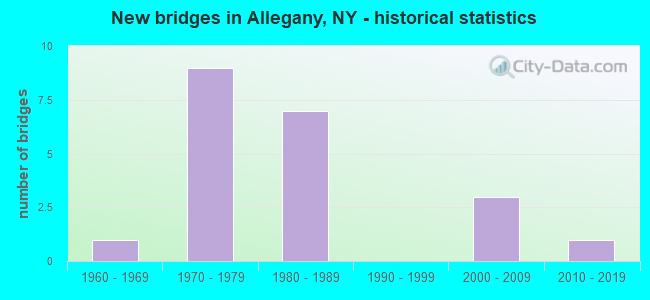
- New bridges - historical statistics
- 11960-1969
- 91970-1979
- 71980-1989
- 32000-2009
- 12010-2019

- Reconstructed bridges - Historical Statistics
- 11990-1999
- 42000-2009
- 12010-2019


- Bridge Condition - Deck
- 46.2%Very good
- 38.5%Good
- 15.4%Satisfactory

- Bridge Condition - Superstructure
- 23.1%Very good
- 53.8%Good
- 7.7%Satisfactory
- 15.4%Poor

- Bridge Condition - Substructure
- 53.8%Very good
- 7.7%Good
- 23.1%Satisfactory
- 15.4%Fair

- Bridge Condition - Channel
- 27.3%Very good
- 36.4%Good
- 27.3%Satisfactory
- 9.1%Fair
Find on map >> Show street view
Structure Number: 101231, Location: W VILLAGE LI OF ALLEGANY (Lat: 42.095014, Lng: -78.501781), Route carried "on" structure: State highway 417, Year Built: 1980, Status: Open, Structure Length: 2.80m (9.19ft), Average Daily Traffic: 4,740 (year 2018), Truck Traffic: 6%, Average Future Daily Traffic: 4,762 (year 2040), Design Load: HS 20, Features Intersected: FIVE MILE CREEK
Minimum Vertical Clearance: 30+ m (98+ ft), Kilometerpoint: 26.854, Lanes on structure: 2, Base Highway Network: Yes, Owner: State Highway Agency, Approaching Roadway Width: 14.6m (47.9ft), Material/Design: Prestressed concrete, Design/Construction: Box Beam or Girders - Multiple, Number Of Spans In Main Unit: 1, Length of Maximum Span: 27.4m (89.9ft), Curb-To-Curb Width: 14.6m (47.9ft), Out-to-Out Width: 15.3m (50.2ft)
Condition: Deck: Good, Superstructure: Good, Substructure: Good, Channel: Good, Operating Rating: 63.5 metric tons, Method Used To Determine Operating Rating: Load and Resistance Factor Rating (LRFR) rating reported by rating factor(RF) method using HL-93 loadings, Inventory Rating: 28.8 metric tons, Method Used To Determine Inventory Rating: Load and Resistance Factor Rating (LRFR) rating reported by rating factor(RF) method using HL-93 loadings, Structural Evaluation: Better than present minimum criteria, Deck Geometry: Superior to present desirable criteria, Waterway Adequacy: Meets minimum limits, Approach Roadway Alignment: Equal to present desirable criteria, Length Of Structure Improvement: 2.80m (9.19ft), Designated Inspection Frequency: Every 24 months, Inspection Date: June 2020, Bridge Improvement Cost: $1,393,000, Roadway Improvement Cost: $816,000, Total Project Cost: $2,209,000 ( Estimate for 2021), Wearing Surface/Protective System: Wearing Surface: Epoxy Overlay
Find on map >> Show street view
Structure Number: 1073791, Location: 6 MI W JCT SH 16 & SH 417 (Lat: 42.101464, Lng: -78.522392), Route carried "on" structure: Interstate 86, Year Built: 1988, Status: Open, Structure Length: 59.16m (194.09ft), Average Daily Traffic: 6,049 (year 2014), Truck Traffic: 17%, Average Future Daily Traffic: 8,469 (year 2034), Design Load: HS 20, Features Intersected: RTE 417, Allegheny River
Minimum Vertical Clearance: 30+ m (98+ ft), Kilometerpoint: 56.798, Lanes on structure: 2, Lanes under structure: 4, Base Highway Network: Yes, Owner: State Highway Agency, Approaching Roadway Width: 12.2m (40.0ft), Skew: 3 degrees, Material/Design: Steel continuous, Design/Construction: Stringer/Multi-beam, Number Of Spans In Main Unit: 13, Length of Maximum Span: 54.8m (179.8ft), Curb-To-Curb Width: 12.0m (39.4ft), Out-to-Out Width: 13.0m (42.7ft)
Condition: Deck: Satisfactory, Superstructure: Good, Substructure: Fair, Channel: Good, Operating Rating: 78.0 metric tons, Method Used To Determine Operating Rating: Load Factor (LF), Inventory Rating: 46.3 metric tons, Method Used To Determine Inventory Rating: Load Factor (LF), Structural Evaluation: Somewhat better than minimum adequacy, Deck Geometry: Equal to present minimum criteria, Underclear: Somewhat better than minimum adequacy, Waterway Adequacy: Equal to present minimum criteria, Approach Roadway Alignment: Equal to present desirable criteria, Length Of Structure Improvement: 59.16m (194.09ft), Designated Inspection Frequency: Every 24 months, Inspection Date: September 2020, Bridge Improvement Cost: $25,581,000, Roadway Improvement Cost: $14,980,000, Total Project Cost: $40,561,000 ( Estimate for 2021), Deck Structure Type: Concrete Cast-file-Place, Wearing Surface/Protective System: Wearing Surface: Integral Concrete, Deck Protection: Epoxy Coated Reinforcing
Find on map >> Show street view
Structure Number: 1073792, Location: 6 MI W JCT SH 16 & SH 417 (Lat: 42.101286, Lng: -78.521831), Route carried "on" structure: Interstate 86, Year Built: 1988, Status: Open, Structure Length: 60.96m (200.00ft), Average Daily Traffic: 4,840 (year 2019), Truck Traffic: 16%, Average Future Daily Traffic: 5,764 (year 2040), Design Load: HS 20, Features Intersected: RTE 417, Allegany River,
Minimum Vertical Clearance: 30+ m (98+ ft), Kilometerpoint: 56.572, Lanes on structure: 2, Lanes under structure: 4, Base Highway Network: Yes, Owner: State Highway Agency, Approaching Roadway Width: 12.2m (40.0ft), Skew: 3 degrees, Material/Design: Steel continuous, Design/Construction: Stringer/Multi-beam, Number Of Spans In Main Unit: 13, Length of Maximum Span: 54.8m (179.8ft), Curb-To-Curb Width: 12.0m (39.4ft), Out-to-Out Width: 13.0m (42.7ft)
Condition: Deck: Good, Superstructure: Good, Substructure: Fair, Channel: Good, Operating Rating: 71.7 metric tons, Method Used To Determine Operating Rating: Load Factor (LF), Inventory Rating: 42.6 metric tons, Method Used To Determine Inventory Rating: Load Factor (LF), Structural Evaluation: Somewhat better than minimum adequacy, Deck Geometry: Equal to present minimum criteria, Underclear: Somewhat better than minimum adequacy, Waterway Adequacy: High priority of replacement, Approach Roadway Alignment: Equal to present desirable criteria, Length Of Structure Improvement: 60.96m (200.00ft), Designated Inspection Frequency: Every 24 months, Inspection Date: September 2020, Bridge Improvement Cost: $26,307,000, Roadway Improvement Cost: $15,405,000, Total Project Cost: $41,712,000 ( Estimate for 2021), Deck Structure Type: Concrete Cast-file-Place, Wearing Surface/Protective System: Wearing Surface: Integral Concrete, Deck Protection: Epoxy Coated Reinforcing
Find on map >> Show street view
Structure Number: 109201, Location: AT INT I86 & RT 952W (Lat: 42.102867, Lng: -78.507464), Route carried "on" structure: State highway 952W, Year Built: 1973, Status: Open, Structure Length: 8.84m (29.00ft), Average Daily Traffic: 3,547 (year 2020), Truck Traffic: 13%, Average Future Daily Traffic: 4,388 (year 2040), Design Load: HS 20, Features Intersected: 86I 17 51123127, RTE I86
Minimum Vertical Clearance: 30+ m (98+ ft), Kilometerpoint: 0.547, Lanes on structure: 2, Lanes under structure: 4, Base Highway Network: Yes, Owner: State Highway Agency, Approaching Roadway Width: 19.5m (64.0ft), Skew: 3 degrees, Material/Design: Steel, Design/Construction: Stringer/Multi-beam, Number Of Spans In Main Unit: 2, Length of Maximum Span: 43.5m (142.7ft), Curb-To-Curb Width: 19.2m (63.0ft), Out-to-Out Width: 20.1m (65.9ft)
Condition: Deck: Good, Superstructure: Satisfactory, Substructure: Satisfactory, Operating Rating: 51.2 metric tons, Method Used To Determine Operating Rating: Load and Resistance Factor Rating (LRFR) rating reported by rating factor(RF) method using HL-93 loadings, Inventory Rating: 39.2 metric tons, Method Used To Determine Inventory Rating: Load and Resistance Factor Rating (LRFR) rating reported by rating factor(RF) method using HL-93 loadings, Structural Evaluation: Equal to present minimum criteria, Deck Geometry: Superior to present desirable criteria, Underclear: Equal to present minimum criteria, Approach Roadway Alignment: Equal to present desirable criteria, Length Of Structure Improvement: 8.83m (28.97ft), Designated Inspection Frequency: Every 24 months, Inspection Date: May 2020, Bridge Improvement Cost: $7,649,000, Roadway Improvement Cost: $4,479,000, Total Project Cost: $12,129,000 ( Estimate for 2021), Deck Structure Type: Concrete Cast-file-Place, Wearing Surface/Protective System: Wearing Surface: Integral Concrete
Find on map >> Show street view
Structure Number: 1092021, Location: 0.6 MI NE JCT 17 + 417 (Lat: 42.102839, Lng: -78.502594), Route carried "on" structure: Interstate 86, Year Built: 1973, Year Reconstructed: 2007, Status: Open, Structure Length: 4.11m (13.48ft), Average Daily Traffic: 5,764 (year 2014), Truck Traffic: 19%, Design Load: HS 20, Features Intersected: FIVE MILE CREEK
Minimum Vertical Clearance: 30+ m (98+ ft), Kilometerpoint: 58.745, Lanes on structure: 2, Base Highway Network: Yes, Owner: State Highway Agency, Approaching Roadway Width: 12.2m (40.0ft), Skew: 1 degrees, Material/Design: Steel, Design/Construction: Stringer/Multi-beam, Number Of Spans In Main Unit: 1, Length of Maximum Span: 39.6m (129.9ft), Curb-To-Curb Width: 12.6m (41.3ft), Out-to-Out Width: 13.5m (44.3ft)
Condition: Deck: Very good, Superstructure: Poor, Substructure: Very good, Channel: Very good, Operating Rating: 47.3 metric tons, Method Used To Determine Operating Rating: Load and Resistance Factor Rating (LRFR) rating reported by rating factor(RF) method using HL-93 loadings, Inventory Rating: 36.6 metric tons, Method Used To Determine Inventory Rating: Load and Resistance Factor Rating (LRFR) rating reported by rating factor(RF) method using HL-93 loadings, Structural Evaluation: Meets minimum limits, Deck Geometry: Better than present minimum criteria, Waterway Adequacy: Superior to present desirable criteria, Approach Roadway Alignment: Equal to present desirable criteria, Length Of Structure Improvement: 4.11m (13.48ft), Designated Inspection Frequency: Every 24 months, Inspection Date: June 2020, Bridge Improvement Cost: $2,966,000, Roadway Improvement Cost: $1,737,000, Total Project Cost: $4,703,000 ( Estimate for 2021), Deck Structure Type: Concrete Cast-file-Place, Wearing Surface/Protective System: Wearing Surface: Monolithic Concrete, Deck Protection: Epoxy Coated Reinforcing
Find on map >> Show street view
Structure Number: 1092022, Location: 0.6 MI NE JCT 17 + 417 (Lat: 42.102503, Lng: -78.502742), Route carried "on" structure: Interstate 86, Year Built: 1973, Year Reconstructed: 2007, Status: Open, Structure Length: 4.02m (13.19ft), Average Daily Traffic: 3,840 (year 2019), Truck Traffic: 17%, Average Future Daily Traffic: 4,303 (year 2040), Design Load: HS 25 or greater, Features Intersected: Five Mile Creek
Minimum Vertical Clearance: 30+ m (98+ ft), Kilometerpoint: 58.745, Lanes on structure: 3, Base Highway Network: Yes, Owner: State Highway Agency, Approaching Roadway Width: 16.5m (54.1ft), Skew: 1 degrees, Material/Design: Steel, Design/Construction: Stringer/Multi-beam, Number Of Spans In Main Unit: 1, Length of Maximum Span: 39.6m (129.9ft), Curb-To-Curb Width: 15.7m (51.5ft), Out-to-Out Width: 16.1m (52.8ft)
Condition: Deck: Very good, Superstructure: Poor, Substructure: Very good, Channel: Very good, Operating Rating: 48.3 metric tons, Method Used To Determine Operating Rating: Load and Resistance Factor Rating (LRFR) rating reported by rating factor(RF) method using HL-93 loadings, Inventory Rating: 37.3 metric tons, Method Used To Determine Inventory Rating: Load and Resistance Factor Rating (LRFR) rating reported by rating factor(RF) method using HL-93 loadings, Structural Evaluation: Meets minimum limits, Deck Geometry: Somewhat better than minimum adequacy, Waterway Adequacy: Superior to present desirable criteria, Approach Roadway Alignment: Equal to present desirable criteria, Length Of Structure Improvement: 4.02m (13.19ft), Designated Inspection Frequency: Every 24 months, Inspection Date: June 2020, Bridge Improvement Cost: $3,521,000, Roadway Improvement Cost: $2,062,000, Total Project Cost: $5,582,000 ( Estimate for 2021), Deck Structure Type: Concrete Cast-file-Place, Wearing Surface/Protective System: Wearing Surface: Monolithic Concrete, Deck Protection: Epoxy Coated Reinforcing
Find on map >> Show street view
Structure Number: 1092031, Location: 0.4 MI E ALLEGANY INT. (Lat: 42.102828, Lng: -78.500100), Route carried "on" structure: Interstate 86, Year Built: 1973, Year Reconstructed: 2007, Status: Open, Structure Length: 3.11m (10.20ft), Average Daily Traffic: 5,764 (year 2014), Truck Traffic: 19%, Design Load: HS 25 or greater, Features Intersected: Five Mile Road
Minimum Vertical Clearance: 30+ m (98+ ft), Kilometerpoint: 58.970, Lanes on structure: 2, Lanes under structure: 2, Base Highway Network: Yes, Owner: State Highway Agency, Approaching Roadway Width: 11.9m (39.0ft), Material/Design: Steel, Design/Construction: Stringer/Multi-beam, Number Of Spans In Main Unit: 1, Length of Maximum Span: 29.9m (98.1ft), Curb-To-Curb Width: 12.0m (39.4ft), Out-to-Out Width: 12.9m (42.3ft)
Condition: Deck: Very good, Superstructure: Good, Substructure: Very good, Operating Rating: 68.4 metric tons, Method Used To Determine Operating Rating: Load and Resistance Factor Rating (LRFR) rating reported by rating factor(RF) method using HL-93 loadings, Inventory Rating: 52.8 metric tons, Method Used To Determine Inventory Rating: Load and Resistance Factor Rating (LRFR) rating reported by rating factor(RF) method using HL-93 loadings, Structural Evaluation: Better than present minimum criteria, Deck Geometry: Equal to present minimum criteria, Underclear: Equal to present minimum criteria, Approach Roadway Alignment: Equal to present desirable criteria, Length Of Structure Improvement: 3.10m (10.17ft), Designated Inspection Frequency: Every 24 months, Inspection Date: October 2020, Bridge Improvement Cost: $2,125,000, Roadway Improvement Cost: $1,244,000, Total Project Cost: $3,369,000 ( Estimate for 2021), Deck Structure Type: Concrete Cast-file-Place, Wearing Surface/Protective System: Wearing Surface: Monolithic Concrete, Deck Protection: Epoxy Coated Reinforcing
Find on map >> Show street view
Structure Number: 1092032, Location: 0.4 MI E ALLEGANY INT. (Lat: 42.102489, Lng: -78.500081), Route carried "on" structure: Interstate 86, Year Built: 1973, Year Reconstructed: 2006, Status: Open, Structure Length: 3.11m (10.20ft), Average Daily Traffic: 3,840 (year 2019), Truck Traffic: 17%, Average Future Daily Traffic: 4,303 (year 2040), Design Load: HS 25 or greater, Features Intersected: FIVE MILE RD
Minimum Vertical Clearance: 30+ m (98+ ft), Kilometerpoint: 59.002, Lanes on structure: 2, Lanes under structure: 2, Base Highway Network: Yes, Owner: State Highway Agency, Approaching Roadway Width: 11.9m (39.0ft), Material/Design: Steel, Design/Construction: Stringer/Multi-beam, Number Of Spans In Main Unit: 1, Length of Maximum Span: 29.9m (98.1ft), Curb-To-Curb Width: 12.0m (39.4ft), Out-to-Out Width: 12.9m (42.3ft)
Condition: Deck: Good, Superstructure: Good, Substructure: Very good, Operating Rating: 66.1 metric tons, Method Used To Determine Operating Rating: Load and Resistance Factor Rating (LRFR) rating reported by rating factor(RF) method using HL-93 loadings, Inventory Rating: 51.2 metric tons, Method Used To Determine Inventory Rating: Load and Resistance Factor Rating (LRFR) rating reported by rating factor(RF) method using HL-93 loadings, Structural Evaluation: Better than present minimum criteria, Deck Geometry: Equal to present minimum criteria, Underclear: High priority of corrective action, Approach Roadway Alignment: Equal to present desirable criteria, Length Of Structure Improvement: 3.10m (10.17ft), Designated Inspection Frequency: Every 24 months, Inspection Date: October 2020, Bridge Improvement Cost: $2,125,000, Roadway Improvement Cost: $1,244,000, Total Project Cost: $3,369,000 ( Estimate for 2021), Deck Structure Type: Concrete Cast-file-Place, Wearing Surface/Protective System: Wearing Surface: Monolithic Concrete, Deck Protection: Epoxy Coated Reinforcing
Find on map >> Show street view
Structure Number: 227105, Location: In Allegany (Lat: 42.139547, Lng: -78.776922), Route carried "on" structure: Other road 951, Year Built: 2014, Status: Temporarily open, Structure Length: 3.23m (10.60ft), Average Daily Traffic: 436 (year 2018), Truck Traffic: 2%, Average Future Daily Traffic: 610 (year 2038), Features Intersected: Phil Creek
Minimum Vertical Clearance: 30+ m (98+ ft), Kilometerpoint: 11.279, Lanes on structure: 2, Owner: State Highway Agency, Approaching Roadway Width: 6.7m (22.0ft), Material/Design: Steel, Design/Construction: Truss - Thru, Number Of Spans In Main Unit: 1, Length of Maximum Span: 31.4m (103.0ft), Curb-To-Curb Width: 6.9m (22.6ft), Out-to-Out Width: 10.4m (34.1ft)
Condition: Deck: Very good, Superstructure: Very good, Substructure: Very good, Channel: Very good, Structural Evaluation: High priority of corrective action, Deck Geometry: Meets minimum limits, Waterway Adequacy: Somewhat better than minimum adequacy, Approach Roadway Alignment: Equal to present minimum criteria, Bridge Posting: Required (Relationship of Operating Rating to Maximum Legal Load: > 39.9% below), Length Of Structure Improvement: 3.23m (10.60ft), Designated Inspection Frequency: Every 24 months, Critical Feature Inspection Frequency: Every 24 months, Inspection Date: November 2021, Critical Feature Inspection Date: November 2021, Bridge Improvement Cost: $2,019,000, Roadway Improvement Cost: $1,182,000, Total Project Cost: $3,201,000 ( Estimate for 2021), Deck Structure Type: Open Grating
Find on map >> Show street view
Structure Number: 332043, Location: 3.6 MI SE OF HUMPHREY (Lat: 42.160092, Lng: -78.504414), Route carried "on" structure: County highway , Year Built: 2002, Status: Open, Structure Length: 1.77m (5.81ft), Average Daily Traffic: 2,240 (year 2020), Truck Traffic: 6%, Average Future Daily Traffic: 2,262 (year 2040), Features Intersected: FIVE MILE CREEK, Facility Carried by Structure: FIVE MILE ROAD
Minimum Vertical Clearance: 30+ m (98+ ft), Kilometerpoint: 6.581, Lanes on structure: 2, Owner: County Highway Agency, Approaching Roadway Width: 10.1m (33.1ft), Material/Design: Prestressed concrete, Design/Construction: Box Beam or Girders - Multiple, Number Of Spans In Main Unit: 1, Length of Maximum Span: 17.1m (56.1ft), Curb-To-Curb Width: 10.3m (33.8ft), Out-to-Out Width: 11.3m (37.1ft)
Condition: Deck: Good, Superstructure: Very good, Substructure: Very good, Channel: Satisfactory, Operating Rating: 79.4 metric tons, Method Used To Determine Operating Rating: Load Factor (LF), Inventory Rating: 47.5 metric tons, Method Used To Determine Inventory Rating: Load Factor (LF), Structural Evaluation: Equal to present desirable criteria, Deck Geometry: Meets minimum limits, Waterway Adequacy: Meets minimum limits, Approach Roadway Alignment: Equal to present desirable criteria, Length Of Structure Improvement: 1.76m (5.77ft), Designated Inspection Frequency: Every 24 months, Inspection Date: July 2020, Bridge Improvement Cost: $471,000, Roadway Improvement Cost: $276,000, Total Project Cost: $747,000 ( Estimate for 2021), Deck Structure Type: Concrete Cast-file-Place, Wearing Surface/Protective System: Wearing Surface: Integral Concrete
Find on map >> Show street view
Structure Number: 332044, Location: 0.16 KM W OF ALLEGANY (Lat: 42.090128, Lng: -78.501594), Route carried "on" structure: County highway , Year Built: 1973, Year Reconstructed: 1998, Status: Open, Structure Length: 12.19m (39.99ft), Average Daily Traffic: 4,773 (year 2020), Truck Traffic: 5%, Average Future Daily Traffic: 5,905 (year 2040), Design Load: HS 25 or greater, Features Intersected: ALLEGHENY RIVER, Facility Carried by Structure: FIVE MILE RD
Minimum Vertical Clearance: 30+ m (98+ ft), Kilometerpoint: 0.080, Lanes on structure: 2, Owner: County Highway Agency, Approaching Roadway Width: 7.9m (25.9ft), Material/Design: Steel continuous, Design/Construction: Stringer/Multi-beam, Number Of Spans In Main Unit: 4, Length of Maximum Span: 30.4m (99.7ft), Curb or Sidewalk Widths: Left: 0.0m, Right: 1.5m (4.9ft), Curb-To-Curb Width: 7.8m (25.6ft), Out-to-Out Width: 9.9m (32.5ft)
Condition: Deck: Satisfactory, Superstructure: Good, Substructure: Satisfactory, Channel: Satisfactory, Operating Rating: 77.1 metric tons, Method Used To Determine Operating Rating: Load Factor (LF), Inventory Rating: 41.7 metric tons, Method Used To Determine Inventory Rating: Load Factor (LF), Structural Evaluation: Equal to present minimum criteria, Deck Geometry: High priority of replacement, Waterway Adequacy: Somewhat better than minimum adequacy, Approach Roadway Alignment: Equal to present desirable criteria, Length Of Structure Improvement: 12.19m (39.99ft), Designated Inspection Frequency: Every 24 months, Inspection Date: August 2020, Bridge Improvement Cost: $4,593,000, Roadway Improvement Cost: $2,690,000, Total Project Cost: $7,283,000 ( Estimate for 2021), Deck Structure Type: Concrete Cast-file-Place, Wearing Surface/Protective System: Wearing Surface: Integral Concrete, Deck Protection: Epoxy Coated Reinforcing
Find on map >> Show street view
Structure Number: 332048, Location: 3.2 MI NORTH OF ALLEGANY (Lat: 42.149322, Lng: -78.508419), Route carried "on" structure: Other road , Year Built: 2005, Status: Open, Structure Length: 1.89m (6.20ft), Average Daily Traffic: 124 (year 2019), Truck Traffic: 1%, Average Future Daily Traffic: 174 (year 2039), Design Load: HS 25 or greater, Features Intersected: FIVEMILE CREEK, Facility Carried by Structure: EATON CROSS ROAD
Minimum Vertical Clearance: 30+ m (98+ ft), Kilometerpoint: 0.193, Lanes on structure: 2, Owner: County Highway Agency, Approaching Roadway Width: 6.1m (20.0ft), Skew: 2 degrees, Material/Design: Prestressed concrete, Design/Construction: Box Beam or Girders - Multiple, Number Of Spans In Main Unit: 1, Length of Maximum Span: 18.0m (59.1ft), Curb-To-Curb Width: 8.0m (26.2ft), Out-to-Out Width: 8.8m (28.9ft)
Condition: Deck: Very good, Superstructure: Very good, Substructure: Very good, Channel: Good, Operating Rating: 72.3 metric tons, Method Used To Determine Operating Rating: Load and Resistance Factor Rating (LRFR) rating reported by rating factor(RF) method using HL-93 loadings, Inventory Rating: 55.7 metric tons, Method Used To Determine Inventory Rating: Load and Resistance Factor Rating (LRFR) rating reported by rating factor(RF) method using HL-93 loadings, Structural Evaluation: Equal to present desirable criteria, Deck Geometry: Somewhat better than minimum adequacy, Waterway Adequacy: Equal to present minimum criteria, Approach Roadway Alignment: Equal to present desirable criteria, Length Of Structure Improvement: 1.88m (6.17ft), Designated Inspection Frequency: Every 24 months, Inspection Date: November 2021, Bridge Improvement Cost: $469,000, Roadway Improvement Cost: $275,000, Total Project Cost: $744,000 ( Estimate for 2021), Deck Structure Type: Concrete Cast-file-Place, Wearing Surface/Protective System: Wearing Surface: Integral Concrete, Deck Protection: Epoxy Coated Reinforcing
Find on map >> Show street view
Structure Number: 336026, Location: 1.0 MI N OF ALLEGANY (Lat: 42.115942, Lng: -78.501600), Route carried "on" structure: Other road , Year Built: 1969, Year Reconstructed: 2015, Status: Posted for load-capacity, Structure Length: 1.83m (6.00ft), Average Daily Traffic: 571 (year 2020), Truck Traffic: 4%, Average Future Daily Traffic: 706 (year 2040), Design Load: H 20, Features Intersected: FIVE MILE CREEK, Facility Carried by Structure: CHAPIN CROSS ROAD
Minimum Vertical Clearance: 30+ m (98+ ft), Kilometerpoint: 0.097, Lanes on structure: 2, Owner: County Highway Agency, Approaching Roadway Width: 5.2m (17.1ft), Material/Design: Steel, Design/Construction: Girder and Floorbeam System, Number Of Spans In Main Unit: 1, Length of Maximum Span: 17.6m (57.7ft), Curb-To-Curb Width: 7.9m (25.9ft), Out-to-Out Width: 8.5m (27.9ft)
Condition: Deck: Very good, Superstructure: Good, Substructure: Satisfactory, Channel: Satisfactory, Operating Rating: 36.0 metric tons, Method Used To Determine Operating Rating: Load and Resistance Factor Rating (LRFR) rating reported by rating factor(RF) method using HL-93 loadings, Inventory Rating: 27.9 metric tons, Method Used To Determine Inventory Rating: Load and Resistance Factor Rating (LRFR) rating reported by rating factor(RF) method using HL-93 loadings, Structural Evaluation: Equal to present minimum criteria, Deck Geometry: Somewhat better than minimum adequacy, Waterway Adequacy: Somewhat better than minimum adequacy, Approach Roadway Alignment: Equal to present desirable criteria, Length Of Structure Improvement: 1.82m (5.97ft), Designated Inspection Frequency: Every 24 months, Critical Feature Inspection Frequency: Every 24 months, Inspection Date: November 2021, Critical Feature Inspection Date: November 2021, Bridge Improvement Cost: $1,367,000, Roadway Improvement Cost: $801,000, Total Project Cost: $2,168,000 ( Estimate for 2021), Deck Structure Type: Wood or Timber, Wearing Surface/Protective System: Wearing Surface: Bituminous, Membrane: Other
Find on map >> Show street view
Structure Number: 336985, Location: 1.5 MI N JCT CR 19 & I86 (Lat: 42.124192, Lng: -78.500914), Route carried "on" structure: County highway , Year Built: 2001, Status: Open, Structure Length: 0.67m (2.20ft), Average Daily Traffic: 3,508 (year 2017), Truck Traffic: 6%, Average Future Daily Traffic: 4,340 (year 2040), Design Load: HS 25 or greater, Features Intersected: SMITH HOLLOW, Facility Carried by Structure: FIVE MILE ROAD
Minimum Vertical Clearance: 30+ m (98+ ft), Kilometerpoint: 2.558, Lanes on structure: 2, Owner: County Highway Agency, Approaching Roadway Width: 8.5m (27.9ft), Material/Design: Concrete, Design/Construction: Culvert, Number Of Spans In Main Unit: 1, Length of Maximum Span: 6.4m (21.0ft)
Condition: Channel: Fair, Culverts: Good, Operating Rating: 78.0 metric tons, Method Used To Determine Operating Rating: Load Factor (LF), Inventory Rating: 46.3 metric tons, Method Used To Determine Inventory Rating: Load Factor (LF), Structural Evaluation: Better than present minimum criteria, Waterway Adequacy: Somewhat better than minimum adequacy, Approach Roadway Alignment: Equal to present desirable criteria, Length Of Structure Improvement: 0.67m (2.20ft), Designated Inspection Frequency: Every 24 months, Inspection Date: July 2021, Bridge Improvement Cost: $245,000, Roadway Improvement Cost: $143,000, Total Project Cost: $388,000 ( Estimate for 2021)
Find on map >> Show street view
Structure Number: 1073791, Location: 6 MI W JCT SH 16 & SH 417 (Lat: 42.101464, Lng: -78.522392), Route carried "under" structure: Alternate State highway 417, Year Built: 1988, Structure Length: 0. m, Average Daily Traffic: 8,400 (year 1985), Features Intersected: RTE 417, Allegheny River, Facility Carried by Structure: RTE I86
Minimum Vertical Clearance: 7.54m (24.74ft), Kilometerpoint: 20.643, Lanes on structure: 2, Lanes under structure: 2, Material/Design: Steel continuous, Design/Construction: Stringer/Multi-beam, Length of Maximum Span: 54.8m (179.8ft)
Find on map >> Show street view
Structure Number: 1073791, Location: 6 MI W JCT SH 16 & SH 417 (Lat: 42.101464, Lng: -78.522392), Route carried "under" structure: County highway , Year Built: 1988, Structure Length: 0. m, Average Daily Traffic: 300 (year 2012), Features Intersected: RTE 417, Allegheny River, Facility Carried by Structure: RTE I86
Minimum Vertical Clearance: 4.50m (14.76ft), Kilometerpoint: 0.000, Lanes on structure: 2, Lanes under structure: 2, Material/Design: Steel continuous, Design/Construction: Stringer/Multi-beam, Length of Maximum Span: 54.8m (179.8ft)
Find on map >> Show street view
Structure Number: 1073792, Location: 6 MI W JCT SH 16 & SH 417 (Lat: 42.101286, Lng: -78.521831), Route carried "under" structure: County highway , Year Built: 1988, Structure Length: 0. m, Average Daily Traffic: 300 (year 2021), Features Intersected: RTE 417, Allegany River,, Facility Carried by Structure: RTE I86
Minimum Vertical Clearance: 5.16m (16.93ft), Kilometerpoint: 0.000, Lanes on structure: 2, Lanes under structure: 2, Material/Design: Steel continuous, Design/Construction: Stringer/Multi-beam, Length of Maximum Span: 54.8m (179.8ft)
Find on map >> Show street view
Structure Number: 1073792, Location: 6 MI W JCT SH 16 & SH 417 (Lat: 42.101286, Lng: -78.521831), Route carried "under" structure: Alternate State highway 417, Year Built: 1988, Structure Length: 0. m, Average Daily Traffic: 8,400 (year 1985), Features Intersected: RTE 417, Allegany River,, Facility Carried by Structure: RTE I86
Minimum Vertical Clearance: 7.19m (23.59ft), Kilometerpoint: 20.643, Lanes on structure: 2, Lanes under structure: 2, Material/Design: Steel continuous, Design/Construction: Stringer/Multi-beam, Length of Maximum Span: 54.8m (179.8ft)
Find on map >> Show street view
Structure Number: 109201, Location: AT INT I86 & RT 952W (Lat: 42.102867, Lng: -78.507464), Route carried "under" structure: Interstate 86, Year Built: 1973, Structure Length: 0. m, Average Daily Traffic: 18,433 (year 1999), Features Intersected: 86I 17 51123127, RTE I86, Facility Carried by Structure: RTE 952W
Minimum Vertical Clearance: 5.13m (16.83ft), Kilometerpoint: 20.820, Lanes on structure: 2, Lanes under structure: 2, Material/Design: Steel, Design/Construction: Stringer/Multi-beam, Length of Maximum Span: 43.5m (142.7ft)
Find on map >> Show street view
Structure Number: 1092031, Location: 0.4 MI E ALLEGANY INT. (Lat: 42.102828, Lng: -78.500100), Route carried "under" structure: Other road , Year Built: 1973, Structure Length: 0. m, Average Daily Traffic: 1,192 (year 2020), Truck Traffic: 4%, Features Intersected: Five Mile Road, Facility Carried by Structure: RTE I86
Minimum Vertical Clearance: 4.44m (14.57ft), Kilometerpoint: 0.129, Lanes on structure: 2, Lanes under structure: 2, Material/Design: Steel, Design/Construction: Stringer/Multi-beam, Length of Maximum Span: 29.9m (98.1ft)
Find on map >> Show street view
Structure Number: 1092032, Location: 0.4 MI E ALLEGANY INT. (Lat: 42.102489, Lng: -78.500081), Route carried "under" structure: Other road , Year Built: 1973, Structure Length: 0. m, Average Daily Traffic: 1,192 (year 2020), Truck Traffic: 4%, Features Intersected: FIVE MILE RD, Facility Carried by Structure: RTE I86
Minimum Vertical Clearance: 4.29m (14.07ft), Kilometerpoint: 0.000, Lanes on structure: 2, Lanes under structure: 2, Material/Design: Steel, Design/Construction: Stringer/Multi-beam, Length of Maximum Span: 29.9m (98.1ft)