Bridge Statistics for Alma, Michigan (MI)
Condition, Traffic, Stress, Structural Evaluation, Project Costs
- National Bridge Inventory (NBI) Statistics
- 27Number of bridges
- 240ft / 73.1mTotal length
- $325,000Total costs
- 155,421Total average daily traffic
- 10,177Total average daily truck traffic
- National Bridge Inventory (NBI) Registered Bridges for Alma
- No street view available for this location
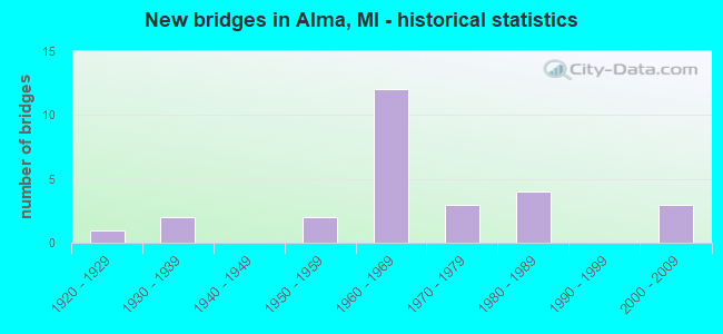
- New bridges - historical statistics
- 11920-1929
- 21930-1939
- 21950-1959
- 121960-1969
- 31970-1979
- 41980-1989
- 32000-2009
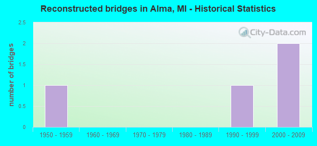
- Reconstructed bridges - Historical Statistics
- 11950-1959
- 01960-1969
- 01970-1979
- 01980-1989
- 11990-1999
- 22000-2009
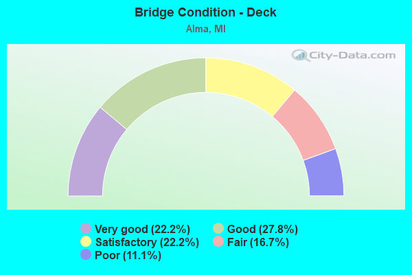
- Bridge Condition - Deck
- 22.2%Very good
- 27.8%Good
- 22.2%Satisfactory
- 16.7%Fair
- 11.1%Poor
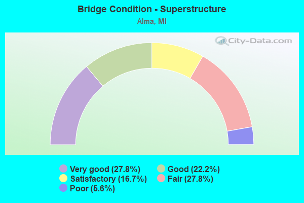
- Bridge Condition - Superstructure
- 27.8%Very good
- 22.2%Good
- 16.7%Satisfactory
- 27.8%Fair
- 5.6%Poor
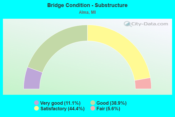
- Bridge Condition - Substructure
- 11.1%Very good
- 38.9%Good
- 44.4%Satisfactory
- 5.6%Fair
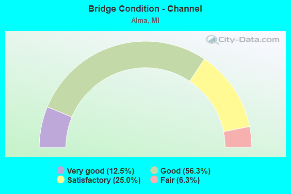
- Bridge Condition - Channel
- 12.5%Very good
- 56.3%Good
- 25.0%Satisfactory
- 6.3%Fair
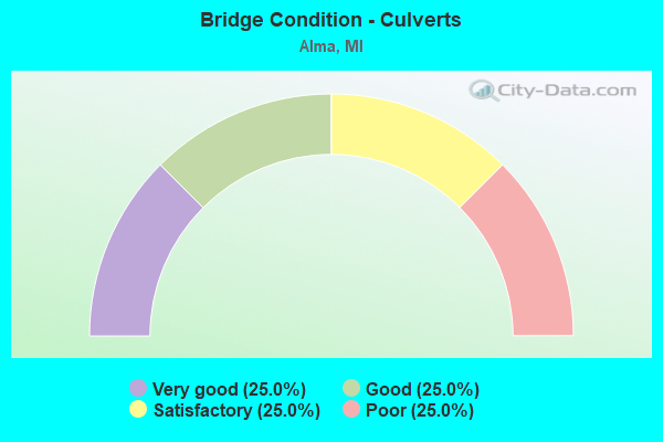
- Bridge Condition - Culverts
- 25.0%Very good
- 25.0%Good
- 25.0%Satisfactory
- 25.0%Poor
Find on map >> Show street view
Structure Number: 2298, Location: 3.0 MI W OF LANSING (Lat: 42.719897, Lng: -84.642414), Route carried "on" structure: County highway 2003, Year Built: 1982, Status: Open, Structure Length: 7.01m (23.00ft), Average Daily Traffic: 980 (year 1988), Truck Traffic: 15%, Average Future Daily Traffic: 1,127 (year 2008), Design Load: HS 20, Features Intersected: I-496, Facility Carried by Structure: CREYTS ROAD SB
Minimum Vertical Clearance: 30.48m (100.00ft), Kilometerpoint: 8.074, Lanes on structure: 3, Lanes under structure: 6, Owner: State Highway Agency, Approaching Roadway Width: 15.2m (49.9ft), Material/Design: Steel continuous, Design/Construction: Stringer/Multi-beam, Number Of Spans In Main Unit: 2, Length of Maximum Span: 35.3m (115.8ft), Curb-To-Curb Width: 14.0m (45.9ft), Out-to-Out Width: 15.1m (49.5ft)
Condition: Deck: Fair, Superstructure: Good, Substructure: Satisfactory, Operating Rating: 69.7 metric tons, Method Used To Determine Operating Rating: Load Factor (LF) rating reported by rating factor (RF) method using MS18 loading, Inventory Rating: 41.8 metric tons, Method Used To Determine Inventory Rating: Load Factor (LF) rating reported by rating factor (RF) method using MS18 loading, Structural Evaluation: Equal to present minimum criteria, Deck Geometry: Somewhat better than minimum adequacy, Underclear: High priority of corrective action, Approach Roadway Alignment: Equal to present desirable criteria, Designated Inspection Frequency: Every 24 months, Inspection Date: October 2021, Deck Structure Type: Concrete Cast-file-Place, Wearing Surface/Protective System: Wearing Surface: Epoxy Overlay, Deck Protection: Epoxy Coated Reinforcing
Find on map >> Show street view
Structure Number: 3104, Location: 0.6 MI N OF ALMA CITY LMT (Lat: 43.402044, Lng: -84.646750), Route carried "on" structure: County highway 2033, Year Built: 1961, Status: Open, Structure Length: 6.95m (22.80ft), Average Daily Traffic: 3,712 (year 1996), Truck Traffic: 1%, Average Future Daily Traffic: 2,890 (year 1977), Design Load: H 20, Features Intersected: US-127, Facility Carried by Structure: BEGOLE RD
Minimum Vertical Clearance: 30.48m (100.00ft), Kilometerpoint: 2.599, Lanes on structure: 2, Lanes under structure: 4, Owner: State Highway Agency, Approaching Roadway Width: 10.9m (35.8ft), Skew: 2 degrees, Material/Design: Steel, Design/Construction: Stringer/Multi-beam, Number Of Spans In Main Unit: 4, Length of Maximum Span: 23.1m (75.8ft), Curb-To-Curb Width: 9.1m (29.9ft), Out-to-Out Width: 10.6m (34.8ft)
Condition: Deck: Fair, Superstructure: Fair, Substructure: Satisfactory, Operating Rating: 55.7 metric tons, Method Used To Determine Operating Rating: Load Factor (LF) rating reported by rating factor (RF) method using MS18 loading, Inventory Rating: 33.4 metric tons, Method Used To Determine Inventory Rating: Load Factor (LF) rating reported by rating factor (RF) method using MS18 loading, Structural Evaluation: Somewhat better than minimum adequacy, Deck Geometry: Meets minimum limits, Underclear: High priority of corrective action, Approach Roadway Alignment: Equal to present desirable criteria, Designated Inspection Frequency: Every 24 months, Inspection Date: May 2021, Deck Structure Type: Concrete Cast-file-Place, Wearing Surface/Protective System: Wearing Surface: Latex Concrete
Find on map >> Show street view
Structure Number: 3105, Location: M 46 & N JCT US 27 BR (Lat: 43.407942, Lng: -84.660856), Route carried "on" structure: State highway 46, Year Built: 1961, Status: Open, Structure Length: 11.12m (36.48ft), Average Daily Traffic: 11,219 (year 2007), Truck Traffic: 6%, Average Future Daily Traffic: 13,037 (year 2018), Design Load: HS 20, Features Intersected: US-127
Minimum Vertical Clearance: 30.48m (100.00ft), Kilometerpoint: 14.935, Lanes on structure: 2, Lanes under structure: 5, Base Highway Network: Yes (Inventory Route: 49, Subroute: 4), Owner: State Highway Agency, Approaching Roadway Width: 10.9m (35.8ft), Skew: 5 degrees, Material/Design: Steel, Design/Construction: Stringer/Multi-beam, Number Of Spans In Main Unit: 4, Length of Maximum Span: 40.5m (132.9ft), Curb-To-Curb Width: 13.4m (44.0ft), Out-to-Out Width: 14.9m (48.9ft)
Condition: Deck: Satisfactory, Superstructure: Fair, Substructure: Satisfactory, Operating Rating: 56.5 metric tons, Method Used To Determine Operating Rating: Load Factor (LF), Inventory Rating: 33.9 metric tons, Method Used To Determine Inventory Rating: Load Factor (LF), Structural Evaluation: Somewhat better than minimum adequacy, Deck Geometry: Equal to present minimum criteria, Underclear: High priority of corrective action, Approach Roadway Alignment: Equal to present desirable criteria, Designated Inspection Frequency: Every 24 months, Inspection Date: May 2021, Deck Structure Type: Concrete Cast-file-Place, Wearing Surface/Protective System: Wearing Surface: Epoxy Overlay
Find on map >> Show street view
Structure Number: 3107, Location: 5.0 MI N OF ITHACA (Lat: 43.364117, Lng: -84.601803), Route carried "on" structure: County highway , Year Built: 1965, Status: Open, Structure Length: 3.84m (12.60ft), Average Daily Traffic: 475 (year 1996), Truck Traffic: 1%, Average Future Daily Traffic: 90 (year 1977), Design Load: H 15, Features Intersected: US-127 SB, Facility Carried by Structure: VAN BUREN RD
Minimum Vertical Clearance: 30.48m (100.00ft), Kilometerpoint: 3.610, Lanes on structure: 2, Lanes under structure: 2, Owner: State Highway Agency, Approaching Roadway Width: 10.9m (35.8ft), Material/Design: Prestressed concrete, Design/Construction: Stringer/Multi-beam, Number Of Spans In Main Unit: 3, Length of Maximum Span: 17.9m (58.7ft), Curb or Sidewalk Widths: Left: 0.7m (2.3ft), Right: 0.7m (2.3ft), Curb-To-Curb Width: 7.3m (24.0ft), Out-to-Out Width: 9.5m (31.2ft)
Condition: Deck: Good, Superstructure: Fair, Substructure: Satisfactory, Operating Rating: 69.0 metric tons, Method Used To Determine Operating Rating: Load Factor (LF) rating reported by rating factor (RF) method using MS18 loading, Inventory Rating: 38.6 metric tons, Method Used To Determine Inventory Rating: Load Factor (LF) rating reported by rating factor (RF) method using MS18 loading, Structural Evaluation: Somewhat better than minimum adequacy, Deck Geometry: Meets minimum limits, Underclear: Somewhat better than minimum adequacy, Approach Roadway Alignment: Better than present minimum criteria, Designated Inspection Frequency: Every 24 months, Inspection Date: May 2021, Deck Structure Type: Concrete Cast-file-Place, Wearing Surface/Protective System: Wearing Surface: Monolithic Concrete
Find on map >> Show street view
Structure Number: 311, Location: 5.0 MI N OF ITHACA (Lat: 43.364114, Lng: -84.600447), Route carried "on" structure: County highway , Year Built: 1965, Status: Open, Structure Length: 3.81m (12.50ft), Average Daily Traffic: 475 (year 1996), Truck Traffic: 1%, Average Future Daily Traffic: 90 (year 1977), Design Load: H 15, Features Intersected: US-127 NB / MID MI PATH, Facility Carried by Structure: VAN BUREN RD
Minimum Vertical Clearance: 30.48m (100.00ft), Kilometerpoint: 3.721, Lanes on structure: 2, Lanes under structure: 2, Owner: State Highway Agency, Approaching Roadway Width: 12.2m (40.0ft), Material/Design: Prestressed concrete, Design/Construction: Stringer/Multi-beam, Number Of Spans In Main Unit: 3, Length of Maximum Span: 17.9m (58.7ft), Curb or Sidewalk Widths: Left: 0.7m (2.3ft), Right: 0.7m (2.3ft), Curb-To-Curb Width: 7.3m (24.0ft), Out-to-Out Width: 9.5m (31.2ft)
Condition: Deck: Good, Superstructure: Satisfactory, Substructure: Good, Operating Rating: 71.6 metric tons, Method Used To Determine Operating Rating: Load Factor (LF) rating reported by rating factor (RF) method using MS18 loading, Inventory Rating: 41.1 metric tons, Method Used To Determine Inventory Rating: Load Factor (LF) rating reported by rating factor (RF) method using MS18 loading, Structural Evaluation: Equal to present minimum criteria, Deck Geometry: Meets minimum limits, Underclear: Somewhat better than minimum adequacy, Approach Roadway Alignment: Equal to present desirable criteria, Designated Inspection Frequency: Every 24 months, Inspection Date: May 2021, Deck Structure Type: Concrete Cast-file-Place, Wearing Surface/Protective System: Wearing Surface: Monolithic Concrete
Find on map >> Show street view
Structure Number: 3111, Location: 2.3 MI W OF ST LOUIS (Lat: 43.407914, Lng: -84.653036), Route carried "on" structure: State highway 46, Year Built: 2002, Status: Open, Structure Length: 0.78m (2.56ft), Average Daily Traffic: 9,986 (year 2007), Truck Traffic: 6%, Average Future Daily Traffic: 13,037 (year 2018), Design Load: HS 25 or greater, Features Intersected: SUGAR CREEK
Minimum Vertical Clearance: 30.48m (100.00ft), Kilometerpoint: 15.569, Lanes on structure: 2, Base Highway Network: Yes (Inventory Route: 49, Subroute: 4), Owner: State Highway Agency, Approaching Roadway Width: 12.8m (42.0ft), Material/Design: Concrete, Design/Construction: Culvert, Number Of Spans In Main Unit: 1, Length of Maximum Span: 7.3m (24.0ft), Curb-To-Curb Width: 13.4m (44.0ft), Out-to-Out Width: 14.6m (47.9ft)
Condition: Channel: Good, Culverts: Good, Operating Rating: 59.9 metric tons, Method Used To Determine Operating Rating: Load Factor (LF) rating reported by rating factor (RF) method using MS18 loading, Inventory Rating: 36.0 metric tons, Method Used To Determine Inventory Rating: Load Factor (LF) rating reported by rating factor (RF) method using MS18 loading, Structural Evaluation: Better than present minimum criteria, Deck Geometry: Equal to present minimum criteria, Waterway Adequacy: Equal to present desirable criteria, Approach Roadway Alignment: Better than present minimum criteria, Designated Inspection Frequency: Every 24 months, Inspection Date: Febuary 2022, Deck Structure Type: Concrete Precast Panels, Wearing Surface/Protective System: Wearing Surface: Bituminous
Find on map >> Show street view
Structure Number: 3113, Location: US-127 BR (Lat: 43.410925, Lng: -84.666739), Route carried "on" structure: Business US 127, Year Built: 1961, Status: Open, Structure Length: 8.43m (27.66ft), Average Daily Traffic: 4,000 (year 2015), Truck Traffic: 4%, Average Future Daily Traffic: 4,375 (year 2033), Design Load: HS 20, Features Intersected: US-127
Minimum Vertical Clearance: 30.48m (100.00ft), Kilometerpoint: 3.737, Lanes on structure: 2, Lanes under structure: 5, Base Highway Network: Yes (Inventory Route: 49, Subroute: 7), Owner: State Highway Agency, Approaching Roadway Width: 10.9m (35.8ft), Skew: 3 degrees, Material/Design: Steel, Design/Construction: Stringer/Multi-beam, Number Of Spans In Main Unit: 4, Length of Maximum Span: 30.8m (101.0ft), Curb-To-Curb Width: 10.0m (32.8ft), Out-to-Out Width: 11.2m (36.7ft)
Condition: Deck: Poor, Superstructure: Fair, Substructure: Good, Operating Rating: 73.9 metric tons, Method Used To Determine Operating Rating: Load Factor (LF) rating reported by rating factor (RF) method using MS18 loading, Inventory Rating: 44.1 metric tons, Method Used To Determine Inventory Rating: Load Factor (LF) rating reported by rating factor (RF) method using MS18 loading, Structural Evaluation: Somewhat better than minimum adequacy, Deck Geometry: Meets minimum limits, Underclear: High priority of corrective action, Approach Roadway Alignment: Equal to present desirable criteria, Designated Inspection Frequency: Every 12 months, Inspection Date: October 2021, Deck Structure Type: Concrete Cast-file-Place, Wearing Surface/Protective System: Wearing Surface: Epoxy Overlay
Find on map >> Show street view
Structure Number: 3125, Location: IN CITY OF ALMA (Lat: 43.378953, Lng: -84.655714), Route carried "on" structure: Business US 127, Year Built: 1928, Year Reconstructed: 1999, Status: Open, Structure Length: 2.86m (9.38ft), Average Daily Traffic: 10,432 (year 2007), Truck Traffic: 6%, Average Future Daily Traffic: 9,512 (year 2018), Design Load: HS 25 or greater, Features Intersected: PINE RIVER
Minimum Vertical Clearance: 30.48m (100.00ft), Kilometerpoint: 23.166, Lanes on structure: 4, Base Highway Network: Yes (Inventory Route: 50, Subroute: 8), Owner: State Highway Agency, Approaching Roadway Width: 13.4m (44.0ft), Material/Design: Prestressed concrete, Design/Construction: Box Beam or Girders - Single/Spread, Number Of Spans In Main Unit: 3, Length of Maximum Span: 9.7m (31.8ft), Curb or Sidewalk Widths: Left: 1.8m (5.9ft), Right: 1.8m (5.9ft), Curb-To-Curb Width: 14.3m (46.9ft), Out-to-Out Width: 17.8m (58.4ft)
Condition: Deck: Satisfactory, Superstructure: Very good, Substructure: Satisfactory, Channel: Good, Operating Rating: 57.7 metric tons, Method Used To Determine Operating Rating: Load Factor (LF) rating reported by rating factor (RF) method using MS18 loading, Inventory Rating: 34.3 metric tons, Method Used To Determine Inventory Rating: Load Factor (LF) rating reported by rating factor (RF) method using MS18 loading, Structural Evaluation: Equal to present minimum criteria, Deck Geometry: High priority of replacement, Waterway Adequacy: Equal to present desirable criteria, Approach Roadway Alignment: Equal to present desirable criteria, Designated Inspection Frequency: Every 24 months, Inspection Date: July 2021, Deck Structure Type: Concrete Cast-file-Place, Wearing Surface/Protective System: Wearing Surface: Monolithic Concrete, Deck Protection: Epoxy Coated Reinforcing
Find on map >> Show street view
Structure Number: 3128, Location: 2.1 MI W OF US 27 (Lat: 43.408128, Lng: -84.702592), Route carried "on" structure: State highway 46, Year Built: 2006, Status: Open, Structure Length: 0.92m (3.02ft), Average Daily Traffic: 6,570 (year 2007), Truck Traffic: 8%, Average Future Daily Traffic: 11,363 (year 2018), Design Load: HS 20+Mod, Features Intersected: W BR PINE RIVER
Minimum Vertical Clearance: 30.48m (100.00ft), Kilometerpoint: 11.555, Lanes on structure: 2, Base Highway Network: Yes (Inventory Route: 49, Subroute: 4), Owner: State Highway Agency, Approaching Roadway Width: 13.4m (44.0ft), Material/Design: Concrete, Design/Construction: Culvert, Number Of Spans In Main Unit: 1, Length of Maximum Span: 8.6m (28.2ft), Curb-To-Curb Width: 13.4m (44.0ft), Out-to-Out Width: 17.2m (56.4ft)
Condition: Channel: Satisfactory, Culverts: Very good, Operating Rating: 65.8 metric tons, Method Used To Determine Operating Rating: Load Factor (LF) rating reported by rating factor (RF) method using MS18 loading, Inventory Rating: 39.2 metric tons, Method Used To Determine Inventory Rating: Load Factor (LF) rating reported by rating factor (RF) method using MS18 loading, Structural Evaluation: Equal to present desirable criteria, Deck Geometry: Equal to present minimum criteria, Waterway Adequacy: Equal to present desirable criteria, Approach Roadway Alignment: Equal to present desirable criteria, Designated Inspection Frequency: Every 24 months, Inspection Date: December 2020, Wearing Surface/Protective System: Wearing Surface: Bituminous
Find on map >> Show street view
Structure Number: 3129, Location: @ PINGREE RD (Lat: 43.408203, Lng: -84.746714), Route carried "on" structure: State highway 46, Year Built: 1936, Year Reconstructed: 1963, Status: Open, Structure Length: 0.84m (2.76ft), Average Daily Traffic: 5,634 (year 2007), Truck Traffic: 9%, Average Future Daily Traffic: 7,954 (year 2018), Design Load: HS 20+Mod, Features Intersected: SEVILLE SUMNER DRAIN
Minimum Vertical Clearance: 30.48m (100.00ft), Kilometerpoint: 7.983, Lanes on structure: 2, Base Highway Network: Yes (Inventory Route: 49, Subroute: 4), Owner: State Highway Agency, Approaching Roadway Width: 11.0m (36.1ft), Skew: 4 degrees, Material/Design: Concrete, Design/Construction: Culvert, Number Of Spans In Main Unit: 1, Length of Maximum Span: 7.4m (24.3ft), Curb-To-Curb Width: 11.0m (36.1ft), Out-to-Out Width: 28.3m (92.8ft)
Condition: Channel: Fair, Culverts: Poor, Operating Rating: 49.6 metric tons, Method Used To Determine Operating Rating: Load Factor (LF) rating reported by rating factor (RF) method using MS18 loading, Inventory Rating: 29.5 metric tons, Method Used To Determine Inventory Rating: Load Factor (LF) rating reported by rating factor (RF) method using MS18 loading, Structural Evaluation: Meets minimum limits, Deck Geometry: Meets minimum limits, Waterway Adequacy: Equal to present minimum criteria, Approach Roadway Alignment: Equal to present minimum criteria, Designated Inspection Frequency: Every 12 months, Inspection Date: May 2021
Find on map >> Show street view
Structure Number: 3161, Location: SEC 16-17 ARCADA TWP (Lat: 43.346858, Lng: -84.686222), Route carried "on" structure: County highway 2929, Year Built: 1988, Status: Open, Structure Length: 0.85m (2.79ft), Average Daily Traffic: 2,590 (year 2003), Average Future Daily Traffic: 3,500 (year 2023), Design Load: HS 20+Mod, Features Intersected: NORTH END DRAIN, Facility Carried by Structure: LUCE ROAD
Minimum Vertical Clearance: 30.48m (100.00ft), Kilometerpoint: 2.097, Lanes on structure: 2, Owner: County Highway Agency, Approaching Roadway Width: 11.9m (39.0ft), Material/Design: Concrete, Design/Construction: Slab, Number Of Spans In Main Unit: 1, Length of Maximum Span: 7.3m (24.0ft), Curb-To-Curb Width: 11.0m (36.1ft), Out-to-Out Width: 12.2m (40.0ft)
Condition: Deck: Very good, Superstructure: Very good, Substructure: Very good, Channel: Very good, Operating Rating: 68.4 metric tons, Method Used To Determine Operating Rating: Load Factor (LF) rating reported by rating factor (RF) method using MS18 loading, Inventory Rating: 40.8 metric tons, Method Used To Determine Inventory Rating: Load Factor (LF) rating reported by rating factor (RF) method using MS18 loading, Structural Evaluation: Equal to present desirable criteria, Deck Geometry: Somewhat better than minimum adequacy, Waterway Adequacy: Equal to present desirable criteria, Approach Roadway Alignment: Equal to present desirable criteria, Designated Inspection Frequency: Every 24 months, Inspection Date: June 2021, Deck Structure Type: Concrete Cast-file-Place, Wearing Surface/Protective System: Wearing Surface: Bituminous, Deck Protection: Epoxy Coated Reinforcing
Find on map >> Show street view
Structure Number: 3162, Location: SEC 4-5 ARCADA TWP (Lat: 43.372458, Lng: -84.686017), Route carried "on" structure: County highway 2929, Year Built: 1957, Status: Open, Structure Length: 3.68m (12.07ft), Average Daily Traffic: 3,850 (year 2003), Average Future Daily Traffic: 5,200 (year 2023), Design Load: HS 20+Mod, Features Intersected: PINE RIVER, Facility Carried by Structure: LUCE ROAD
Minimum Vertical Clearance: 30.48m (100.00ft), Kilometerpoint: 4.939, Lanes on structure: 2, Owner: County Highway Agency, Approaching Roadway Width: 10.1m (33.1ft), Skew: 1 degrees, Material/Design: Steel, Design/Construction: Stringer/Multi-beam, Number Of Spans In Main Unit: 2, Length of Maximum Span: 17.9m (58.7ft), Curb or Sidewalk Widths: Left: 0.8m (2.6ft), Right: 0.8m (2.6ft), Curb-To-Curb Width: 7.0m (23.0ft), Out-to-Out Width: 8.9m (29.2ft)
Condition: Deck: Fair, Superstructure: Fair, Substructure: Satisfactory, Channel: Good, Operating Rating: 58.0 metric tons, Method Used To Determine Operating Rating: Load Factor (LF), Inventory Rating: 34.8 metric tons, Method Used To Determine Inventory Rating: Load Factor (LF), Structural Evaluation: Somewhat better than minimum adequacy, Deck Geometry: High priority of replacement, Waterway Adequacy: Better than present minimum criteria, Approach Roadway Alignment: Better than present minimum criteria, Designated Inspection Frequency: Every 12 months, Inspection Date: June 2021, Bridge Improvement Cost: $250,000, Roadway Improvement Cost: $10,000, Total Project Cost: $325,000, Deck Structure Type: Concrete Cast-file-Place, Wearing Surface/Protective System: Wearing Surface: Bituminous
Find on map >> Show street view
Structure Number: 3163, Location: SEC 21-22 ARCADA TWP (Lat: 43.335164, Lng: -84.666744), Route carried "on" structure: County highway , Year Built: 1957, Status: Open, Structure Length: 1.06m (3.48ft), Average Daily Traffic: 1,835 (year 2003), Average Future Daily Traffic: 2,475 (year 2023), Design Load: HS 20+Mod, Features Intersected: NORTH END DRAIN, Facility Carried by Structure: ALGER ROAD
Minimum Vertical Clearance: 30.48m (100.00ft), Kilometerpoint: 4.809, Lanes on structure: 2, Owner: County Highway Agency, Approaching Roadway Width: 9.1m (29.9ft), Skew: 2 degrees, Material/Design: Concrete, Design/Construction: Slab, Number Of Spans In Main Unit: 1, Length of Maximum Span: 9.7m (31.8ft), Curb-To-Curb Width: 7.0m (23.0ft), Out-to-Out Width: 8.9m (29.2ft)
Condition: Deck: Satisfactory, Superstructure: Satisfactory, Substructure: Satisfactory, Channel: Good, Operating Rating: 47.3 metric tons, Method Used To Determine Operating Rating: Load Factor (LF) rating reported by rating factor (RF) method using MS18 loading, Inventory Rating: 28.5 metric tons, Method Used To Determine Inventory Rating: Load Factor (LF) rating reported by rating factor (RF) method using MS18 loading, Structural Evaluation: Equal to present minimum criteria, Deck Geometry: High priority of corrective action, Waterway Adequacy: Better than present minimum criteria, Approach Roadway Alignment: Equal to present minimum criteria, Designated Inspection Frequency: Every 24 months, Inspection Date: June 2021, Deck Structure Type: Concrete Cast-file-Place, Wearing Surface/Protective System: Wearing Surface: Bituminous
Find on map >> Show street view
Structure Number: 318, Location: SEC 8-17 ARCADA TWP (Lat: 43.349897, Lng: -84.690797), Route carried "on" structure: County highway 2966, Year Built: 1977, Status: Open, Structure Length: 3.93m (12.89ft), Average Daily Traffic: 1,020 (year 2003), Average Future Daily Traffic: 1,380 (year 2023), Design Load: HS 20+Mod, Features Intersected: PINE RIVER, Facility Carried by Structure: HARRISON ROAD
Minimum Vertical Clearance: 30.48m (100.00ft), Kilometerpoint: 12.510, Lanes on structure: 2, Owner: County Highway Agency, Approaching Roadway Width: 10.1m (33.1ft), Skew: 4 degrees, Material/Design: Prestressed concrete, Design/Construction: Box Beam or Girders - Multiple, Number Of Spans In Main Unit: 2, Length of Maximum Span: 19.2m (63.0ft), Curb-To-Curb Width: 10.1m (33.1ft), Out-to-Out Width: 10.2m (33.5ft)
Condition: Deck: Good, Superstructure: Good, Substructure: Very good, Channel: Satisfactory, Operating Rating: 64.6 metric tons, Method Used To Determine Operating Rating: Load Factor (LF), Inventory Rating: 38.7 metric tons, Method Used To Determine Inventory Rating: Load Factor (LF), Structural Evaluation: Better than present minimum criteria, Deck Geometry: Somewhat better than minimum adequacy, Waterway Adequacy: Equal to present desirable criteria, Approach Roadway Alignment: Equal to present desirable criteria, Designated Inspection Frequency: Every 24 months, Inspection Date: June 2021, Deck Structure Type: Concrete Precast Panels, Wearing Surface/Protective System: Wearing Surface: Bituminous, Membrane: Built-up
Find on map >> Show street view
Structure Number: 3181, Location: SEC 18-19 ARCADA TWP (Lat: 43.335503, Lng: -84.709908), Route carried "on" structure: County highway , Year Built: 1986, Status: Open, Structure Length: 3.35m (10.99ft), Average Daily Traffic: 155 (year 2020), Truck Traffic: 5%, Average Future Daily Traffic: 230 (year 2040), Design Load: HS 20+Mod, Features Intersected: PINE RIVER, Facility Carried by Structure: TYLER ROAD
Minimum Vertical Clearance: 30.48m (100.00ft), Kilometerpoint: 9.402, Lanes on structure: 2, Owner: County Highway Agency, Approaching Roadway Width: 8.5m (27.9ft), Skew: 1 degrees, Material/Design: Prestressed concrete, Design/Construction: Box Beam or Girders - Multiple, Number Of Spans In Main Unit: 2, Length of Maximum Span: 16.7m (54.8ft), Curb-To-Curb Width: 8.5m (27.9ft), Out-to-Out Width: 9.5m (31.2ft)
Condition: Deck: Good, Superstructure: Good, Substructure: Satisfactory, Channel: Good, Operating Rating: 37.6 metric tons, Method Used To Determine Operating Rating: Load and Resistance Factor Rating (LRFR) rating reported by rating factor(RF) method using HL-93 loadings, Inventory Rating: 29.2 metric tons, Method Used To Determine Inventory Rating: Load and Resistance Factor Rating (LRFR) rating reported by rating factor(RF) method using HL-93 loadings, Structural Evaluation: Equal to present minimum criteria, Deck Geometry: Equal to present minimum criteria, Waterway Adequacy: Equal to present desirable criteria, Approach Roadway Alignment: Equal to present desirable criteria, Designated Inspection Frequency: Every 24 months, Inspection Date: July 2020, Deck Structure Type: Concrete Precast Panels, Wearing Surface/Protective System: Wearing Surface: Bituminous, Membrane: Preformed Fabric
Find on map >> Show street view
Structure Number: 3182, Location: SEC 5 ARCADA TWP (Lat: 43.371611, Lng: -84.695336), Route carried "on" structure: County highway , Year Built: 1968, Status: Posted for load, Structure Length: 1.25m (4.10ft), Average Daily Traffic: 790 (year 2004), Truck Traffic: 7%, Average Future Daily Traffic: 970 (year 2024), Design Load: HS 20+Mod, Features Intersected: DRAIN #96, Facility Carried by Structure: RIVERVIEW DRIVE
Minimum Vertical Clearance: 30.48m (100.00ft), Kilometerpoint: 0.861, Lanes on structure: 2, Owner: County Highway Agency, Approaching Roadway Width: 6.7m (22.0ft), Material/Design: Steel, Design/Construction: Stringer/Multi-beam, Number Of Spans In Main Unit: 1, Length of Maximum Span: 10.9m (35.8ft), Curb-To-Curb Width: 8.2m (26.9ft), Out-to-Out Width: 8.4m (27.6ft)
Condition: Deck: Poor, Superstructure: Poor, Substructure: Fair, Channel: Satisfactory, Operating Rating: 36.9 metric tons, Method Used To Determine Operating Rating: Load Factor (LF) rating reported by rating factor (RF) method using MS18 loading, Inventory Rating: 22.0 metric tons, Method Used To Determine Inventory Rating: Load Factor (LF) rating reported by rating factor (RF) method using MS18 loading, Structural Evaluation: Meets minimum limits, Deck Geometry: Somewhat better than minimum adequacy, Waterway Adequacy: Better than present minimum criteria, Approach Roadway Alignment: High priority of corrective action, Bridge Posting: Required (Relationship of Operating Rating to Maximum Legal Load: 10.0 - 19.9% below), Designated Inspection Frequency: Every 12 months, Inspection Date: June 2021, Deck Structure Type: Corrugated Steel, Wearing Surface/Protective System: Wearing Surface: Bituminous
Find on map >> Show street view
Structure Number: 3235, Location: SEC 30-31 PINE RIVER TWP (Lat: 43.393672, Lng: -84.712172), Route carried "on" structure: County highway , Year Built: 1985, Status: Open, Structure Length: 1.00m (3.28ft), Average Daily Traffic: 211 (year 2004), Truck Traffic: 7%, Average Future Daily Traffic: 255 (year 2024), Design Load: HS 20+Mod, Features Intersected: DRAIN #73, Facility Carried by Structure: JACKSON ROAD
Minimum Vertical Clearance: 30.48m (100.00ft), Kilometerpoint: 9.236, Lanes on structure: 2, Owner: County Highway Agency, Approaching Roadway Width: 4.9m (16.1ft), Material/Design: Prestressed concrete, Design/Construction: Box Beam or Girders - Multiple, Number Of Spans In Main Unit: 1, Length of Maximum Span: 9.1m (29.9ft), Curb-To-Curb Width: 8.2m (26.9ft), Out-to-Out Width: 8.5m (27.9ft)
Condition: Deck: Very good, Superstructure: Very good, Substructure: Good, Channel: Very good, Operating Rating: 66.0 metric tons, Method Used To Determine Operating Rating: Load Factor (LF), Inventory Rating: 39.6 metric tons, Method Used To Determine Inventory Rating: Load Factor (LF), Structural Evaluation: Better than present minimum criteria, Deck Geometry: Somewhat better than minimum adequacy, Waterway Adequacy: Better than present minimum criteria, Approach Roadway Alignment: Better than present minimum criteria, Designated Inspection Frequency: Every 24 months, Inspection Date: July 2020, Deck Structure Type: Concrete Precast Panels, Wearing Surface/Protective System: Wearing Surface: Bituminous, Membrane: Preformed Fabric, Deck Protection: Epoxy Coated Reinforcing
Find on map >> Show street view
Structure Number: 3237, Location: SEC 31-32 PINE RIVER TWP (Lat: 43.379728, Lng: -84.706597), Route carried "on" structure: County highway , Year Built: 2003, Status: Open, Structure Length: 1.22m (4.00ft), Average Daily Traffic: 177 (year 2004), Truck Traffic: 7%, Average Future Daily Traffic: 225 (year 2024), Design Load: HS 25 or greater, Features Intersected: W BR PINE RIVER, Facility Carried by Structure: WINANS ROAD
Minimum Vertical Clearance: 30.48m (100.00ft), Kilometerpoint: 0.064, Lanes on structure: 2, Owner: County Highway Agency, Approaching Roadway Width: 9.1m (29.9ft), Material/Design: Prestressed concrete, Design/Construction: Box Beam or Girders - Multiple, Number Of Spans In Main Unit: 1, Length of Maximum Span: 11.0m (36.1ft), Curb-To-Curb Width: 9.4m (30.8ft), Out-to-Out Width: 10.5m (34.4ft)
Condition: Deck: Very good, Superstructure: Very good, Substructure: Good, Channel: Good, Inventory Rating: 61.0 metric tons, Method Used To Determine Inventory Rating: Load Factor (LF), Structural Evaluation: Better than present minimum criteria, Deck Geometry: Equal to present minimum criteria, Waterway Adequacy: Superior to present desirable criteria, Approach Roadway Alignment: Equal to present desirable criteria, Designated Inspection Frequency: Every 24 months, Inspection Date: July 2020, Deck Structure Type: Concrete Cast-file-Place, Wearing Surface/Protective System: Wearing Surface: Monolithic Concrete, Deck Protection: Epoxy Coated Reinforcing
Find on map >> Show street view
Structure Number: 3245, Location: SEC 1 SUMNER TWP (Lat: 43.377872, Lng: -84.736550), Route carried "on" structure: County highway , Year Built: 1978, Status: Open, Structure Length: 0.76m (2.49ft), Average Daily Traffic: 116 (year 2004), Truck Traffic: 7%, Average Future Daily Traffic: 144 (year 2024), Design Load: HS 20+Mod, Features Intersected: DRAIN #290, Facility Carried by Structure: PENDELL ROAD
Minimum Vertical Clearance: 30.48m (100.00ft), Kilometerpoint: 1.469, Lanes on structure: 2, Owner: County Highway Agency, Approaching Roadway Width: 6.1m (20.0ft), Material/Design: Steel, Design/Construction: Culvert, Number Of Spans In Main Unit: 1, Length of Maximum Span: 7.6m (24.9ft), Curb-To-Curb Width: 6.1m (20.0ft), Out-to-Out Width: 14.9m (48.9ft)
Condition: Channel: Good, Culverts: Satisfactory, Operating Rating: 45.5 metric tons, Method Used To Determine Operating Rating: Load Factor (LF), Inventory Rating: 18.2 metric tons, Method Used To Determine Inventory Rating: Load Factor (LF), Structural Evaluation: Somewhat better than minimum adequacy, Deck Geometry: Meets minimum limits, Waterway Adequacy: Better than present minimum criteria, Approach Roadway Alignment: Equal to present minimum criteria, Designated Inspection Frequency: Every 24 months, Inspection Date: July 2020
Find on map >> Show street view
Structure Number: 3251, Location: 0.59 M N US27A IN ALMA (Lat: 43.387314, Lng: -84.646856), Route carried "on" structure: City street 2033, Year Built: 1966, Year Reconstructed: 2011, Status: Open, Structure Length: 3.05m (10.01ft), Average Daily Traffic: 4,698 (year 2009), Truck Traffic: 5%, Average Future Daily Traffic: 5,600 (year 2029), Design Load: HS 20, Features Intersected: PINE RIVER, Facility Carried by Structure: BRIDGE AVENUE
Minimum Vertical Clearance: 30.48m (100.00ft), Kilometerpoint: 0.950, Lanes on structure: 2, Owner: City or Municipal Highway Agency, Approaching Roadway Width: 7.9m (25.9ft), Skew: 2 degrees, Material/Design: Prestressed concrete, Design/Construction: Box Beam or Girders - Single/Spread, Number Of Spans In Main Unit: 1, Length of Maximum Span: 30.0m (98.4ft), Curb or Sidewalk Widths: Left: 1.5m (4.9ft), Right: 1.5m (4.9ft), Curb-To-Curb Width: 7.9m (25.9ft), Out-to-Out Width: 11.6m (38.1ft)
Condition: Deck: Very good, Superstructure: Good, Substructure: Good, Channel: Good, Operating Rating: 84.2 metric tons, Method Used To Determine Operating Rating: Load and Resistance Factor Rating (LRFR) rating reported by rating factor(RF) method using HL-93 loadings, Inventory Rating: 65.1 metric tons, Method Used To Determine Inventory Rating: Load and Resistance Factor Rating (LRFR) rating reported by rating factor(RF) method using HL-93 loadings, Structural Evaluation: Better than present minimum criteria, Deck Geometry: High priority of corrective action, Waterway Adequacy: Equal to present desirable criteria, Approach Roadway Alignment: Equal to present desirable criteria, Designated Inspection Frequency: Every 24 months, Inspection Date: August 2021, Deck Structure Type: Concrete Cast-file-Place, Wearing Surface/Protective System: Wearing Surface: Monolithic Concrete, Deck Protection: Epoxy Coated Reinforcing
Find on map >> Show street view
Structure Number: 3252, Location: 0.2 MI S US-27BR IN ALMA (Lat: 43.375167, Lng: -84.660267), Route carried "on" structure: City street 2033, Year Built: 1979, Status: Open, Structure Length: 3.20m (10.50ft), Average Daily Traffic: 2,991 (year 1994), Truck Traffic: 5%, Average Future Daily Traffic: 3,800 (year 2022), Design Load: HS 20+Mod, Features Intersected: PINE RIVER, Facility Carried by Structure: WOODWORTH AVENUE
Minimum Vertical Clearance: 30.48m (100.00ft), Kilometerpoint: 0.089, Lanes on structure: 3, Owner: City or Municipal Highway Agency, Approaching Roadway Width: 14.6m (47.9ft), Skew: 1 degrees, Material/Design: Concrete continuous, Design/Construction: Slab, Number Of Spans In Main Unit: 3, Length of Maximum Span: 10.7m (35.1ft), Curb or Sidewalk Widths: Left: 1.5m (4.9ft), Right: 1.5m (4.9ft), Curb-To-Curb Width: 14.6m (47.9ft), Out-to-Out Width: 18.4m (60.4ft)
Condition: Deck: Satisfactory, Superstructure: Satisfactory, Substructure: Good, Channel: Satisfactory, Operating Rating: 43.7 metric tons, Method Used To Determine Operating Rating: Load Factor (LF) rating reported by rating factor (RF) method using MS18 loading, Inventory Rating: 26.2 metric tons, Method Used To Determine Inventory Rating: Load Factor (LF) rating reported by rating factor (RF) method using MS18 loading, Structural Evaluation: Equal to present minimum criteria, Deck Geometry: Somewhat better than minimum adequacy, Waterway Adequacy: Superior to present desirable criteria, Approach Roadway Alignment: Equal to present desirable criteria, Designated Inspection Frequency: Every 24 months, Inspection Date: August 2021, Deck Structure Type: Concrete Cast-file-Place, Wearing Surface/Protective System: Wearing Surface: Monolithic Concrete
Find on map >> Show street view
Structure Number: 3253, Location: 0.15MSUS27AINALMA (Lat: 43.375486, Lng: -84.661847), Route carried "on" structure: City street 2033, Year Built: 1938, Year Reconstructed: 2000, Status: Open, Structure Length: 3.20m (10.50ft), Average Daily Traffic: 5,225 (year 2000), Truck Traffic: 5%, Average Future Daily Traffic: 11,604 (year 2020), Design Load: HS 25 or greater, Features Intersected: PINE RIVER, Facility Carried by Structure: NORTH STATE STREET
Minimum Vertical Clearance: 30.48m (100.00ft), Kilometerpoint: 0.121, Lanes on structure: 2, Owner: City or Municipal Highway Agency, Approaching Roadway Width: 9.1m (29.9ft), Material/Design: Prestressed concrete, Design/Construction: Box Beam or Girders - Multiple, Number Of Spans In Main Unit: 3, Length of Maximum Span: 10.6m (34.8ft), Curb or Sidewalk Widths: Left: 1.5m (4.9ft), Right: 1.5m (4.9ft), Curb-To-Curb Width: 9.1m (29.9ft), Out-to-Out Width: 13.0m (42.7ft)
Condition: Deck: Good, Superstructure: Very good, Substructure: Good, Channel: Good, Operating Rating: 97.2 metric tons, Method Used To Determine Operating Rating: Load Factor (LF) rating reported by rating factor (RF) method using MS18 loading, Inventory Rating: 60.9 metric tons, Method Used To Determine Inventory Rating: Load Factor (LF) rating reported by rating factor (RF) method using MS18 loading, Structural Evaluation: Better than present minimum criteria, Deck Geometry: High priority of corrective action, Waterway Adequacy: Equal to present desirable criteria, Approach Roadway Alignment: Equal to present desirable criteria, Designated Inspection Frequency: Every 24 months, Inspection Date: August 2021, Deck Structure Type: Concrete Cast-file-Place, Wearing Surface/Protective System: Wearing Surface: Integral Concrete, Deck Protection: Epoxy Coated Reinforcing
Find on map >> Show street view
Structure Number: 3104, Location: 0.6 MI N OF ALMA CITY LMT (Lat: 43.402044, Lng: -84.646750), Route carried "under" structure: US 127, Year Built: 1961, Structure Length: 0. m, Average Daily Traffic: 16,586 (year 2007), Truck Traffic: 8%, Features Intersected: US-127, Facility Carried by Structure: BEGOLE RD
Minimum Vertical Clearance: 4.57m (14.99ft), Kilometerpoint: 34.520, Lanes on structure: 2, Lanes under structure: 4, Material/Design: Steel, Design/Construction: Stringer/Multi-beam, Length of Maximum Span: 23.1m (75.8ft)
Find on map >> Show street view
Structure Number: 3105, Location: M 46 & N JCT US 27 BR (Lat: 43.407942, Lng: -84.660856), Route carried "under" structure: US 127, Year Built: 1961, Structure Length: 0. m, Average Daily Traffic: 20,238 (year 2007), Truck Traffic: 9%, Features Intersected: US-127
Minimum Vertical Clearance: 4.65m (15.26ft), Kilometerpoint: 35.830, Lanes on structure: 2, Lanes under structure: 5, Material/Design: Steel, Design/Construction: Stringer/Multi-beam, Length of Maximum Span: 40.5m (132.9ft)
Find on map >> Show street view
Structure Number: 3107, Location: 5.0 MI N OF ITHACA (Lat: 43.364117, Lng: -84.601803), Route carried "under" structure: US 127, Year Built: 1965, Structure Length: 0. m, Average Daily Traffic: 9,181 (year 2007), Truck Traffic: 8%, Features Intersected: US-127 SB, Facility Carried by Structure: VAN BUREN RD
Minimum Vertical Clearance: 5.00m (16.40ft), Kilometerpoint: 28.436, Lanes on structure: 2, Lanes under structure: 2, Material/Design: Prestressed concrete, Design/Construction: Stringer/Multi-beam, Length of Maximum Span: 17.9m (58.7ft)
Find on map >> Show street view
Structure Number: 311, Location: 5.0 MI N OF ITHACA (Lat: 43.364114, Lng: -84.600447), Route carried "under" structure: US 127, Year Built: 1965, Structure Length: 0. m, Average Daily Traffic: 11,300 (year 2016), Truck Traffic: 9%, Features Intersected: US-127 NB / MID MI PATH, Facility Carried by Structure: VAN BUREN RD
Minimum Vertical Clearance: 5.00m (16.40ft), Kilometerpoint: 28.404, Lanes on structure: 2, Lanes under structure: 2, Material/Design: Prestressed concrete, Design/Construction: Stringer/Multi-beam, Length of Maximum Span: 17.9m (58.7ft)
Find on map >> Show street view
Structure Number: 3113, Location: US-127 BR (Lat: 43.410925, Lng: -84.666739), Route carried "under" structure: US 127, Year Built: 1961, Structure Length: 0. m, Average Daily Traffic: 20,975 (year 2015), Truck Traffic: 6%, Features Intersected: US-127
Minimum Vertical Clearance: 4.40m (14.44ft), Kilometerpoint: 36.434, Lanes on structure: 2, Lanes under structure: 5, Material/Design: Steel, Design/Construction: Stringer/Multi-beam, Length of Maximum Span: 30.8m (101.0ft)