Bridge Statistics for Alma, Texas (TX)
Condition, Traffic, Stress, Structural Evaluation, Project Costs
- National Bridge Inventory (NBI) Statistics
- 12Number of bridges
- 59ft / 18.4mTotal length
- 163,742Total average daily traffic
- 35,259Total average daily truck traffic
- National Bridge Inventory (NBI) Registered Bridges for Alma
- No street view available for this location
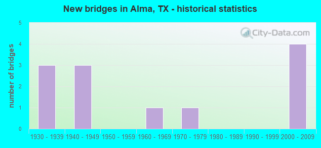
- New bridges - historical statistics
- 31930-1939
- 31940-1949
- 11960-1969
- 11970-1979
- 42000-2009

- Reconstructed bridges - Historical Statistics
- 11950-1959
- 11960-1969
- 31970-1979
- 01980-1989
- 11990-1999


- Bridge Condition - Deck
- 66.7%Good
- 33.3%Imminent failure

- Bridge Condition - Superstructure
- 66.7%Good
- 33.3%Failed

- Bridge Condition - Substructure
- 66.7%Good
- 33.3%Failed

- Bridge Condition - Channel
- 37.5%Good
- 50.0%Satisfactory
- 12.5%Serious

- Bridge Condition - Culverts
- 28.6%Good
- 28.6%Satisfactory
- 42.9%Fair
Find on map >> Show street view
Structure Number: 18071000920503, Location: 0.5 MI NW OF FM 1183 (Lat: 32.289550, Lng: -96.552511), Route carried "on" structure: ServiceState highway 45, Year Built: 1935, Year Reconstructed: 1950, Status: Open, Structure Length: 1.13m (3.71ft), Average Daily Traffic: 270 (year 2013), Truck Traffic: 20%, Average Future Daily Traffic: 380 (year 2033), Design Load: H 15, Features Intersected: DRAW
Minimum Vertical Clearance: 30+ m (98+ ft), Kilometerpoint: 4.963, Lanes on structure: 2, Owner: State Highway Agency, Approaching Roadway Width: 7.6m (24.9ft), Material/Design: Concrete, Design/Construction: Culvert, Number Of Spans In Main Unit: 8, Length of Maximum Span: 1.2m (3.9ft), Curb-To-Curb Width: 11.1m (36.4ft), Out-to-Out Width: 11.8m (38.7ft)
Condition: Channel: Satisfactory, Culverts: Fair, Operating Rating: 39.9 metric tons, Method Used To Determine Operating Rating: Load Factor (LF), Inventory Rating: 23.6 metric tons, Method Used To Determine Inventory Rating: Load Factor (LF), Structural Evaluation: Somewhat better than minimum adequacy, Deck Geometry: Equal to present minimum criteria, Waterway Adequacy: Equal to present minimum criteria, Approach Roadway Alignment: Equal to present desirable criteria, Length Of Structure Improvement: 1.13m (3.71ft), Designated Inspection Frequency: Every 24 months, Inspection Date: September 2021, Deck Structure Type: Concrete Cast-file-Place, Wearing Surface/Protective System: Wearing Surface: Bituminous
Find on map >> Show street view
Structure Number: 180710009205031, Location: 0.8 MI SE OF FM 1183 (Lat: 32.281431, Lng: -96.534003), Route carried "on" structure: Interstate 45, Year Built: 1930, Year Reconstructed: 1960, Status: Open, Structure Length: 1.40m (4.59ft), Average Daily Traffic: 49,013 (year 2020), Truck Traffic: 20%, Average Future Daily Traffic: 64,370 (year 2033), Design Load: H 15, Features Intersected: DRAW
Minimum Vertical Clearance: 30+ m (98+ ft), Kilometerpoint: 3.005, Lanes on structure: 10, Owner: State Highway Agency, Approaching Roadway Width: 48.8m (160.1ft), Skew: 29 degrees, Material/Design: Concrete, Design/Construction: Culvert, Number Of Spans In Main Unit: 3, Length of Maximum Span: 3.0m (9.8ft)
Condition: Channel: Satisfactory, Culverts: Fair, Operating Rating: 39.9 metric tons, Method Used To Determine Operating Rating: Load Factor (LF), Inventory Rating: 23.6 metric tons, Method Used To Determine Inventory Rating: Load Factor (LF), Structural Evaluation: Somewhat better than minimum adequacy, Waterway Adequacy: Equal to present minimum criteria, Approach Roadway Alignment: Equal to present desirable criteria, Designated Inspection Frequency: Every 24 months, Inspection Date: November 2021
Find on map >> Show street view
Structure Number: 180710009205158, Location: 0.5 MI NW OF FM 1183 (Lat: 32.289842, Lng: -96.552308), Route carried "on" structure: Interstate 45, Year Built: 1960, Year Reconstructed: 1999, Status: Open, Structure Length: 1.07m (3.51ft), Average Daily Traffic: 51,459 (year 2020), Truck Traffic: 20%, Average Future Daily Traffic: 66,050 (year 2033), Features Intersected: DRAW
Minimum Vertical Clearance: 30+ m (98+ ft), Kilometerpoint: 4.963, Lanes on structure: 8, Owner: State Highway Agency, Approaching Roadway Width: 36.0m (118.1ft), Skew: 20 degrees, Material/Design: Concrete, Design/Construction: Culvert, Number Of Spans In Main Unit: 4, Length of Maximum Span: 2.4m (7.9ft)
Condition: Channel: Good, Culverts: Satisfactory, Operating Rating: 32.7 metric tons, Method Used To Determine Operating Rating: Field evaluation and documented engineering judgment, Inventory Rating: 24.5 metric tons, Method Used To Determine Inventory Rating: Field evaluation and documented engineering judgment, Structural Evaluation: Equal to present minimum criteria, Waterway Adequacy: Equal to present minimum criteria, Approach Roadway Alignment: Equal to present desirable criteria, Designated Inspection Frequency: Every 24 months, Inspection Date: September 2021
Find on map >> Show street view
Structure Number: 180710009205356, Location: 3.40 MI SE OF FM 85 (Lat: 32.286967, Lng: -96.545461), Route carried "on" structure: Interstate 45, Year Built: 2000, Status: Open, Structure Length: 4.88m (16.01ft), Average Daily Traffic: 26,359 (year 2019), Truck Traffic: 28%, Average Future Daily Traffic: 30,590 (year 2031), Design Load: HS 20, Features Intersected: FM 1183
Minimum Vertical Clearance: 30+ m (98+ ft), Kilometerpoint: 4.233, Lanes on structure: 3, Lanes under structure: 2, Owner: State Highway Agency, Approaching Roadway Width: 15.9m (52.2ft), Material/Design: Prestressed concrete, Design/Construction: Box Beam or Girders - Multiple, Number Of Spans In Main Unit: 1, Number Of Approach Spans: 2, Length of Maximum Span: 24.4m (80.1ft), Curb-To-Curb Width: 15.6m (51.2ft), Out-to-Out Width: 16.5m (54.1ft)
Condition: Deck: Good, Superstructure: Good, Substructure: Good, Operating Rating: 54.4 metric tons, Method Used To Determine Operating Rating: Assigned rating based on Load Factor Design (LFD) reported in metric tons, Inventory Rating: 32.7 metric tons, Method Used To Determine Inventory Rating: Assigned rating based on Load Factor Design (LFD) reported in metric tons, Structural Evaluation: Better than present minimum criteria, Deck Geometry: Somewhat better than minimum adequacy, Underclear: Meets minimum limits, Approach Roadway Alignment: Equal to present desirable criteria, Designated Inspection Frequency: Every 24 months, Inspection Date: October 2021, Deck Structure Type: Concrete Cast-file-Place
Find on map >> Show street view
Structure Number: 180710009205357, Location: 3.40 MI SE OF FM 85 (Lat: 32.286817, Lng: -96.545794), Route carried "on" structure: Interstate 45, Year Built: 2000, Status: Open, Structure Length: 4.88m (16.01ft), Average Daily Traffic: 26,305 (year 2019), Truck Traffic: 28%, Average Future Daily Traffic: 30,590 (year 2031), Design Load: HS 20, Features Intersected: FM 1183
Minimum Vertical Clearance: 30+ m (98+ ft), Kilometerpoint: 4.233, Lanes on structure: 3, Lanes under structure: 2, Owner: State Highway Agency, Approaching Roadway Width: 15.2m (49.9ft), Material/Design: Prestressed concrete, Design/Construction: Box Beam or Girders - Multiple, Number Of Spans In Main Unit: 1, Number Of Approach Spans: 2, Length of Maximum Span: 24.4m (80.1ft), Curb-To-Curb Width: 15.0m (49.2ft), Out-to-Out Width: 15.9m (52.2ft)
Condition: Deck: Good, Superstructure: Good, Substructure: Good, Operating Rating: 54.4 metric tons, Method Used To Determine Operating Rating: Assigned rating based on Load Factor Design (LFD) reported in metric tons, Inventory Rating: 32.7 metric tons, Method Used To Determine Inventory Rating: Assigned rating based on Load Factor Design (LFD) reported in metric tons, Structural Evaluation: Better than present minimum criteria, Deck Geometry: Meets minimum limits, Underclear: Meets minimum limits, Approach Roadway Alignment: Equal to present desirable criteria, Designated Inspection Frequency: Every 24 months, Inspection Date: October 2021, Deck Structure Type: Concrete Cast-file-Place
Find on map >> Show street view
Structure Number: 180710105001006, Location: 3.0 MI W OF FM 1182 (Lat: 32.312647, Lng: -96.515314), Route carried "on" structure: State highway 85, Year Built: 1949, Year Reconstructed: 1970, Status: Open, Structure Length: 0.70m (2.30ft), Average Daily Traffic: 1,791 (year 2020), Truck Traffic: 4%, Average Future Daily Traffic: 2,240 (year 2033), Design Load: H 15, Features Intersected: BURNS BRANCH RELIEF
Minimum Vertical Clearance: 30+ m (98+ ft), Kilometerpoint: 23.871, Lanes on structure: 2, Owner: State Highway Agency, Approaching Roadway Width: 9.8m (32.2ft), Skew: 9 degrees, Material/Design: Concrete, Design/Construction: Culvert, Number Of Spans In Main Unit: 4, Length of Maximum Span: 1.5m (4.9ft)
Condition: Channel: Good, Culverts: Satisfactory, Operating Rating: 32.7 metric tons, Method Used To Determine Operating Rating: Field evaluation and documented engineering judgment, Inventory Rating: 24.5 metric tons, Method Used To Determine Inventory Rating: Field evaluation and documented engineering judgment, Structural Evaluation: Equal to present minimum criteria, Waterway Adequacy: Equal to present minimum criteria, Approach Roadway Alignment: Equal to present desirable criteria, Designated Inspection Frequency: Every 24 months, Inspection Date: September 2021
Find on map >> Show street view
Structure Number: 180710105001007, Location: 3.0 MI W OF FM 1182 (Lat: 32.312494, Lng: -96.514869), Route carried "on" structure: State highway 85, Year Built: 1949, Year Reconstructed: 1970, Status: Open, Structure Length: 1.04m (3.41ft), Average Daily Traffic: 1,791 (year 2020), Truck Traffic: 4%, Average Future Daily Traffic: 2,240 (year 2033), Design Load: H 15, Features Intersected: BURNS BRANCH
Minimum Vertical Clearance: 30+ m (98+ ft), Kilometerpoint: 23.921, Lanes on structure: 2, Owner: State Highway Agency, Approaching Roadway Width: 9.8m (32.2ft), Material/Design: Concrete, Design/Construction: Culvert, Number Of Spans In Main Unit: 5, Length of Maximum Span: 1.8m (5.9ft)
Condition: Channel: Good, Culverts: Good, Operating Rating: 32.7 metric tons, Method Used To Determine Operating Rating: Field evaluation and documented engineering judgment, Inventory Rating: 24.5 metric tons, Method Used To Determine Inventory Rating: Field evaluation and documented engineering judgment, Structural Evaluation: Equal to present minimum criteria, Waterway Adequacy: Equal to present minimum criteria, Approach Roadway Alignment: Equal to present desirable criteria, Designated Inspection Frequency: Every 24 months, Inspection Date: September 2021
Find on map >> Show street view
Structure Number: 180710105001008, Location: 0.8 MI W OF FM 1182 (Lat: 32.313836, Lng: -96.478269), Route carried "on" structure: State highway 85, Year Built: 1949, Year Reconstructed: 1970, Status: Open, Structure Length: 1.22m (4.00ft), Average Daily Traffic: 1,791 (year 2020), Truck Traffic: 4%, Average Future Daily Traffic: 2,240 (year 2033), Design Load: H 15, Features Intersected: HOBB BRANCH
Minimum Vertical Clearance: 30+ m (98+ ft), Kilometerpoint: 27.517, Lanes on structure: 2, Owner: State Highway Agency, Approaching Roadway Width: 9.1m (29.9ft), Material/Design: Concrete, Design/Construction: Culvert, Number Of Spans In Main Unit: 6, Length of Maximum Span: 1.8m (5.9ft), Curb-To-Curb Width: 9.1m (29.9ft), Out-to-Out Width: 21.9m (71.9ft)
Condition: Channel: Satisfactory, Culverts: Fair, Operating Rating: 32.7 metric tons, Method Used To Determine Operating Rating: Field evaluation and documented engineering judgment, Inventory Rating: 24.5 metric tons, Method Used To Determine Inventory Rating: Field evaluation and documented engineering judgment, Structural Evaluation: Somewhat better than minimum adequacy, Deck Geometry: Somewhat better than minimum adequacy, Waterway Adequacy: Equal to present minimum criteria, Approach Roadway Alignment: Equal to present desirable criteria, Designated Inspection Frequency: Every 24 months, Inspection Date: September 2021, Deck Structure Type: Concrete Cast-file-Place, Wearing Surface/Protective System: Wearing Surface: Bituminous
Find on map >> Show street view
Structure Number: 180710105001015, Location: 3.3 MI E OF FM 3413 (Lat: 32.324219, Lng: -96.535647), Route carried "on" structure: State highway 85, Year Built: 1970, Status: Open, Structure Length: 1.04m (3.41ft), Average Daily Traffic: 2,259 (year 2020), Truck Traffic: 4%, Average Future Daily Traffic: 2,650 (year 2033), Design Load: HS 20, Features Intersected: DRAW
Minimum Vertical Clearance: 30+ m (98+ ft), Kilometerpoint: 21.570, Lanes on structure: 2, Owner: State Highway Agency, Approaching Roadway Width: 9.1m (29.9ft), Skew: 1 degrees, Material/Design: Concrete, Design/Construction: Culvert, Number Of Spans In Main Unit: 5, Length of Maximum Span: 1.8m (5.9ft), Curb-To-Curb Width: 9.1m (29.9ft), Out-to-Out Width: 24.1m (79.1ft)
Condition: Channel: Satisfactory, Culverts: Good, Operating Rating: 39.9 metric tons, Method Used To Determine Operating Rating: Load Factor (LF), Inventory Rating: 23.6 metric tons, Method Used To Determine Inventory Rating: Load Factor (LF), Structural Evaluation: Equal to present minimum criteria, Deck Geometry: Meets minimum limits, Waterway Adequacy: Equal to present minimum criteria, Approach Roadway Alignment: Equal to present desirable criteria, Designated Inspection Frequency: Every 24 months, Inspection Date: September 2021, Deck Structure Type: Concrete Cast-file-Place, Wearing Surface/Protective System: Wearing Surface: Bituminous
Find on map >> Show street view
Structure Number: 180710F00001001, Location: 0.83 MI SE of FM 1183 (Lat: 32.279811, Lng: -96.533831), Route carried "on" structure: State highway , Year Built: 1930, Status: Closed, Structure Length: 1.04m (3.41ft), Average Daily Traffic: 1,084 (year 2020), Average Future Daily Traffic: 40 (year 2035), Features Intersected: Draw, Facility Carried by Structure: Old Alma Road
Minimum Vertical Clearance: 30+ m (98+ ft), Kilometerpoint: 1.336, Lanes on structure: 2, Owner: City or Municipal Highway Agency, Approaching Roadway Width: 6.7m (22.0ft), Material/Design: Concrete continuous, Design/Construction: Slab, Number Of Spans In Main Unit: 3, Length of Maximum Span: 3.7m (12.1ft), Curb-To-Curb Width: 7.3m (24.0ft), Out-to-Out Width: 8.1m (26.6ft)
Condition: Deck: Imminent failure, Superstructure: Failed, Substructure: Failed, Channel: Serious, Deck Geometry: Meets minimum limits, Waterway Adequacy: Meets minimum limits, Approach Roadway Alignment: Somewhat better than minimum adequacy, Bridge Posting: Required (Relationship of Operating Rating to Maximum Legal Load: > 39.9% below), Designated Inspection Frequency: Every 24 months, Inspection Date: Febuary 2021, Deck Structure Type: Concrete Cast-file-Place, Wearing Surface/Protective System: Wearing Surface: Other
Find on map >> Show street view
Structure Number: 180710009205356, Location: 3.40 MI SE OF FM 85 (Lat: 32.286967, Lng: -96.545461), Route carried "under" structure: State highway 1183, Year Built: 2000, Structure Length: 0. m, Average Daily Traffic: 810 (year 2013), Truck Traffic: 4%, Features Intersected: FM 1183, Facility Carried by Structure: IH 45 NB
Minimum Vertical Clearance: 5.49m (18.01ft), Kilometerpoint: 15.961, Lanes on structure: 3, Lanes under structure: 2, Material/Design: Prestressed concrete, Design/Construction: Box Beam or Girders - Multiple, Length of Maximum Span: 24.4m (80.1ft)
Find on map >> Show street view
Structure Number: 180710009205357, Location: 3.40 MI SE OF FM 85 (Lat: 32.286817, Lng: -96.545794), Route carried "under" structure: State highway 1183, Year Built: 2000, Structure Length: 0. m, Average Daily Traffic: 810 (year 2013), Truck Traffic: 4%, Features Intersected: FM 1183, Facility Carried by Structure: IH 45 SB
Minimum Vertical Clearance: 5.26m (17.26ft), Kilometerpoint: 15.937, Lanes on structure: 3, Lanes under structure: 2, Material/Design: Prestressed concrete, Design/Construction: Box Beam or Girders - Multiple, Length of Maximum Span: 24.4m (80.1ft)