Bridge Statistics for Ama, Louisiana (LA)
Condition, Traffic, Stress, Structural Evaluation, Project Costs
- National Bridge Inventory (NBI) Statistics
- 10Number of bridges
- 571ft / 174mTotal length
- $1,109,000Total costs
- 118,500Total average daily traffic
- 11,850Total average daily truck traffic
- National Bridge Inventory (NBI) Registered Bridges for Ama
- No street view available for this location
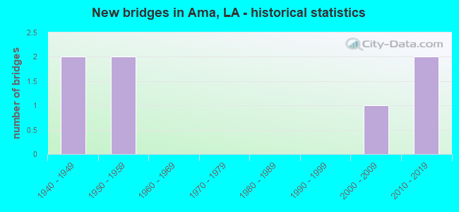
- New bridges - historical statistics
- 21940-1949
- 21950-1959
- 12000-2009
- 22010-2019

- Bridge Condition - Deck
- 14.3%Very good
- 42.9%Good
- 42.9%Satisfactory

- Bridge Condition - Superstructure
- 28.6%Very good
- 14.3%Good
- 42.9%Satisfactory
- 14.3%Fair

- Bridge Condition - Substructure
- 42.9%Very good
- 14.3%Good
- 14.3%Satisfactory
- 28.6%Fair

- Bridge Condition - Channel
- 20.0%Very good
- 40.0%Satisfactory
- 40.0%Fair
Find on map >> Show street view
Structure Number: 24500000020431, Location: 3.0 MILES EAST OF LA 632 (Lat: 29.916950, Lng: -90.316900), Route carried "on" structure: US 90, Year Built: 2002, Status: Open, Structure Length: 10.79m (35.40ft), Average Daily Traffic: 11,850 (year 2016), Truck Traffic: 10%, Average Future Daily Traffic: 23,664 (year 2036), Design Load: HS 20, Features Intersected: DAVIS POND DIVERSION
Minimum Vertical Clearance: 30+ m (98+ ft), Kilometerpoint: 4.435, Lanes on structure: 2, Base Highway Network: Yes (Inventory Route: 5-09-2, Subroute: 10), Owner: State Highway Agency, Approaching Roadway Width: 12.2m (40.0ft), Skew: 31 degrees, Material/Design: Prestressed concrete, Design/Construction: Stringer/Multi-beam, Number Of Spans In Main Unit: 6, Length of Maximum Span: 18.0m (59.1ft), Curb-To-Curb Width: 12.2m (40.0ft), Out-to-Out Width: 13.7m (44.9ft)
Condition: Deck: Very good, Superstructure: Very good, Substructure: Very good, Channel: Very good, Operating Rating: 79.1 metric tons, Method Used To Determine Operating Rating: Load and Resistance Factor Rating (LRFR) rating reported by rating factor(RF) method using HL-93 loadings, Inventory Rating: 74.5 metric tons, Method Used To Determine Inventory Rating: Load and Resistance Factor Rating (LRFR) rating reported by rating factor(RF) method using HL-93 loadings, Structural Evaluation: Equal to present desirable criteria, Deck Geometry: Better than present minimum criteria, Waterway Adequacy: Equal to present desirable criteria, Approach Roadway Alignment: Equal to present desirable criteria, Designated Inspection Frequency: Every 24 months, Underwater Inspection Frequency: Every 60 months, Inspection Date: September 2020, Underwater Inspection Date: January 2021, Deck Structure Type: Concrete Cast-file-Place, Wearing Surface/Protective System: Wearing Surface: Monolithic Concrete
Find on map >> Show street view
Structure Number: 24500000020504, Location: 4.9 MI. E. OF INT. WITH L (Lat: 29.916550, Lng: -90.311669), Route carried "on" structure: US 90, Year Built: 2013, Status: Open, Structure Length: 77.42m (254.00ft), Average Daily Traffic: 11,850 (year 2016), Truck Traffic: 10%, Average Future Daily Traffic: 23,664 (year 2036), Design Load: HS 20, Features Intersected: US 90 TURNAROUNDS
Minimum Vertical Clearance: 30+ m (98+ ft), Kilometerpoint: 7.886, Lanes on structure: 2, Lanes under structure: 1, Base Highway Network: Yes (Inventory Route: 5-09-1, Subroute: 10), Owner: State Highway Agency, Approaching Roadway Width: 11.6m (38.1ft), Skew: 30 degrees, Material/Design: Prestressed concrete continuous, Design/Construction: Stringer/Multi-beam, Number Of Spans In Main Unit: 30, Number Of Approach Spans: 22, Length of Maximum Span: 21.3m (69.9ft), Curb-To-Curb Width: 11.6m (38.1ft), Out-to-Out Width: 12.2m (40.0ft)
Condition: Deck: Good, Superstructure: Very good, Substructure: Very good, Operating Rating: 51.5 metric tons, Method Used To Determine Operating Rating: Load and Resistance Factor Rating (LRFR) rating reported by rating factor(RF) method using HL-93 loadings, Inventory Rating: 39.9 metric tons, Method Used To Determine Inventory Rating: Load and Resistance Factor Rating (LRFR) rating reported by rating factor(RF) method using HL-93 loadings, Structural Evaluation: Equal to present desirable criteria, Deck Geometry: Better than present minimum criteria, Underclear: Somewhat better than minimum adequacy, Approach Roadway Alignment: Equal to present desirable criteria, Designated Inspection Frequency: Every 24 months, Inspection Date: June 2021, Deck Structure Type: Concrete Cast-file-Place, Wearing Surface/Protective System: Wearing Surface: Monolithic Concrete
Find on map >> Show street view
Structure Number: 24500000020505, Location: 4.9 MI. E OF INT. WITH LA (Lat: 29.916239, Lng: -90.304361), Route carried "on" structure: US 90, Year Built: 2013, Status: Open, Structure Length: 77.42m (254.00ft), Average Daily Traffic: 11,850 (year 2016), Truck Traffic: 10%, Average Future Daily Traffic: 23,664 (year 2036), Design Load: HS 20, Features Intersected: US 90 TURNAROUNDS
Minimum Vertical Clearance: 30+ m (98+ ft), Kilometerpoint: 3.285, Lanes on structure: 2, Lanes under structure: 1, Base Highway Network: Yes (Inventory Route: 5-09-2, Subroute: 10), Owner: State Highway Agency, Approaching Roadway Width: 11.6m (38.1ft), Skew: 30 degrees, Material/Design: Prestressed concrete continuous, Design/Construction: Stringer/Multi-beam, Number Of Spans In Main Unit: 30, Number Of Approach Spans: 22, Length of Maximum Span: 21.3m (69.9ft), Curb-To-Curb Width: 11.6m (38.1ft), Out-to-Out Width: 12.2m (40.0ft)
Condition: Deck: Good, Superstructure: Good, Substructure: Very good, Operating Rating: 51.5 metric tons, Method Used To Determine Operating Rating: Load and Resistance Factor Rating (LRFR) rating reported by rating factor(RF) method using HL-93 loadings, Inventory Rating: 39.9 metric tons, Method Used To Determine Inventory Rating: Load and Resistance Factor Rating (LRFR) rating reported by rating factor(RF) method using HL-93 loadings, Structural Evaluation: Better than present minimum criteria, Deck Geometry: Better than present minimum criteria, Underclear: Somewhat better than minimum adequacy, Approach Roadway Alignment: Equal to present desirable criteria, Designated Inspection Frequency: Every 24 months, Inspection Date: June 2021, Deck Structure Type: Concrete Cast-file-Place, Wearing Surface/Protective System: Wearing Surface: Monolithic Concrete
Find on map >> Show street view
Structure Number: 24500050905861, Location: 4.3 MI EAST OF LA 633 (Lat: 29.915681, Lng: -90.296700), Route carried "on" structure: US 90, Year Built: 1953, Status: Open, Structure Length: 1.80m (5.91ft), Average Daily Traffic: 11,850 (year 2016), Truck Traffic: 10%, Average Future Daily Traffic: 23,664 (year 2036), Design Load: HS 20, Features Intersected: DRAIN CANAL
Minimum Vertical Clearance: 30+ m (98+ ft), Kilometerpoint: 9.439, Lanes on structure: 2, Base Highway Network: Yes (Inventory Route: 5-09-1, Subroute: 10), Owner: State Highway Agency, Approaching Roadway Width: 9.8m (32.2ft), Skew: 10 degrees, Material/Design: Concrete, Design/Construction: Tee Beam, Number Of Spans In Main Unit: 2, Length of Maximum Span: 8.5m (27.9ft), Curb-To-Curb Width: 7.0m (23.0ft), Out-to-Out Width: 9.1m (29.9ft)
Condition: Deck: Satisfactory, Superstructure: Satisfactory, Substructure: Good, Channel: Satisfactory, Operating Rating: 53.5 metric tons, Method Used To Determine Operating Rating: Load Factor (LF), Inventory Rating: 32.7 metric tons, Method Used To Determine Inventory Rating: Load Factor (LF), Structural Evaluation: Equal to present minimum criteria, Deck Geometry: High priority of replacement, Waterway Adequacy: Equal to present minimum criteria, Approach Roadway Alignment: Equal to present desirable criteria, Designated Inspection Frequency: Every 24 months, Inspection Date: April 2020, Deck Structure Type: Concrete Cast-file-Place, Wearing Surface/Protective System: Wearing Surface: Bituminous
Find on map >> Show street view
Structure Number: 24500050905862, Location: 4.3 MI EAST OF LA 633 (Lat: 29.915750, Lng: -90.296500), Route carried "on" structure: US 90, Year Built: 1940, Status: Open, Structure Length: 1.74m (5.71ft), Average Daily Traffic: 11,850 (year 2016), Truck Traffic: 10%, Average Future Daily Traffic: 23,664 (year 2036), Design Load: H 15, Features Intersected: DRAIN CANAL
Minimum Vertical Clearance: 30+ m (98+ ft), Kilometerpoint: 2.459, Lanes on structure: 2, Base Highway Network: Yes (Inventory Route: 5-09-2, Subroute: 10), Owner: State Highway Agency, Approaching Roadway Width: 9.8m (32.2ft), Skew: 10 degrees, Material/Design: Concrete, Design/Construction: Tee Beam, Number Of Spans In Main Unit: 2, Length of Maximum Span: 8.5m (27.9ft), Curb-To-Curb Width: 7.0m (23.0ft), Out-to-Out Width: 9.1m (29.9ft)
Condition: Deck: Good, Superstructure: Satisfactory, Substructure: Satisfactory, Channel: Satisfactory, Operating Rating: 50.8 metric tons, Method Used To Determine Operating Rating: Load Factor (LF), Inventory Rating: 29.9 metric tons, Method Used To Determine Inventory Rating: Load Factor (LF), Structural Evaluation: Equal to present minimum criteria, Deck Geometry: High priority of replacement, Waterway Adequacy: Equal to present minimum criteria, Approach Roadway Alignment: Equal to present desirable criteria, Length Of Structure Improvement: 2.44m (8.01ft), Designated Inspection Frequency: Every 24 months, Inspection Date: April 2020, Bridge Improvement Cost: $208,000, Total Project Cost: $312,000 ( Estimate for 2016), Deck Structure Type: Concrete Cast-file-Place, Wearing Surface/Protective System: Wearing Surface: Bituminous
Find on map >> Show street view
Structure Number: 24500050907151, Location: 5.6 MI EAST OF LA 633 (Lat: 29.914389, Lng: -90.275300), Route carried "on" structure: US 90, Year Built: 1953, Status: Open, Structure Length: 2.38m (7.81ft), Average Daily Traffic: 11,850 (year 2016), Truck Traffic: 10%, Average Future Daily Traffic: 23,664 (year 2036), Design Load: HS 20, Features Intersected: SELLERS CANAL
Minimum Vertical Clearance: 30+ m (98+ ft), Kilometerpoint: 11.510, Lanes on structure: 2, Base Highway Network: Yes (Inventory Route: 5-09-1, Subroute: 10), Owner: State Highway Agency, Approaching Roadway Width: 9.8m (32.2ft), Skew: 10 degrees, Material/Design: Concrete, Design/Construction: Tee Beam, Number Of Spans In Main Unit: 2, Length of Maximum Span: 11.6m (38.1ft), Curb-To-Curb Width: 7.0m (23.0ft), Out-to-Out Width: 9.1m (29.9ft)
Condition: Deck: Satisfactory, Superstructure: Satisfactory, Substructure: Fair, Channel: Fair, Operating Rating: 52.6 metric tons, Method Used To Determine Operating Rating: Load Factor (LF), Inventory Rating: 31.7 metric tons, Method Used To Determine Inventory Rating: Load Factor (LF), Structural Evaluation: Somewhat better than minimum adequacy, Deck Geometry: High priority of replacement, Waterway Adequacy: Better than present minimum criteria, Approach Roadway Alignment: Equal to present desirable criteria, Length Of Structure Improvement: 3.14m (10.30ft), Designated Inspection Frequency: Every 24 months, Underwater Inspection Frequency: Every 60 months, Inspection Date: September 2020, Underwater Inspection Date: March 2019, Bridge Improvement Cost: $267,000, Total Project Cost: $400,000 ( Estimate for 2016), Deck Structure Type: Concrete Cast-file-Place, Wearing Surface/Protective System: Wearing Surface: Bituminous
Find on map >> Show street view
Structure Number: 24500050907152, Location: 5.6 MI EAST OF LA 633 (Lat: 29.914461, Lng: -90.275000), Route carried "on" structure: US 90, Year Built: 1940, Status: Open, Structure Length: 2.35m (7.71ft), Average Daily Traffic: 11,850 (year 2016), Truck Traffic: 10%, Average Future Daily Traffic: 23,664 (year 2036), Design Load: H 15, Features Intersected: SELLERS CANAL
Minimum Vertical Clearance: 30+ m (98+ ft), Kilometerpoint: 0.385, Lanes on structure: 2, Base Highway Network: Yes (Inventory Route: 5-09-2, Subroute: 10), Owner: State Highway Agency, Approaching Roadway Width: 9.8m (32.2ft), Skew: 30 degrees, Material/Design: Concrete, Design/Construction: Tee Beam, Number Of Spans In Main Unit: 2, Length of Maximum Span: 11.6m (38.1ft), Curb or Sidewalk Widths: Left: 1.1m (3.6ft), Right: 0.0m, Curb-To-Curb Width: 7.3m (24.0ft), Out-to-Out Width: 9.1m (29.9ft)
Condition: Deck: Satisfactory, Superstructure: Fair, Substructure: Fair, Channel: Fair, Operating Rating: 48.1 metric tons, Method Used To Determine Operating Rating: Load Factor (LF), Inventory Rating: 29.0 metric tons, Method Used To Determine Inventory Rating: Load Factor (LF), Structural Evaluation: Somewhat better than minimum adequacy, Deck Geometry: High priority of replacement, Waterway Adequacy: Better than present minimum criteria, Approach Roadway Alignment: Equal to present desirable criteria, Length Of Structure Improvement: 3.11m (10.20ft), Designated Inspection Frequency: Every 24 months, Underwater Inspection Frequency: Every 60 months, Inspection Date: September 2021, Underwater Inspection Date: March 2019, Bridge Improvement Cost: $265,000, Total Project Cost: $397,000 ( Estimate for 2016), Deck Structure Type: Concrete Cast-file-Place, Wearing Surface/Protective System: Wearing Surface: Bituminous
Find on map >> Show street view
Structure Number: 24500000020504, Location: 4.5 MI. E. OF INT WITH LA (Lat: 29.916669, Lng: -90.312700), Route carried "under" structure: US 90, Structure Length: 0. m, Average Daily Traffic: 11,850 (year 2016), Truck Traffic: 10%, Features Intersected: US 90 EB U-TURN TO US 90
Minimum Vertical Clearance: 30+ m (98+ ft), Kilometerpoint: 7.886, Lanes on structure: 2, Lanes under structure: 1, Length of Maximum Span: 0.0m
Find on map >> Show street view
Structure Number: 24500000020504, Location: 4.9 MI E. OF INT. WITH LA (Lat: 29.916669, Lng: -90.312700), Route carried "under" structure: US 90, Structure Length: 0. m, Average Daily Traffic: 11,850 (year 2016), Truck Traffic: 10%, Features Intersected: US 90 WB U-TURN TO US 90
Minimum Vertical Clearance: 30+ m (98+ ft), Kilometerpoint: 7.886, Lanes on structure: 2, Lanes under structure: 1, Length of Maximum Span: 0.0m
Find on map >> Show street view
Structure Number: 24500000020505, Location: 4.9 MI E OF INT WITH LA (Lat: 29.916669, Lng: -90.312700), Route carried "under" structure: US 90, Structure Length: 0. m, Average Daily Traffic: 11,850 (year 2016), Truck Traffic: 10%, Features Intersected: US 90 EB U-TURN TO US 90
Minimum Vertical Clearance: 30+ m (98+ ft), Kilometerpoint: 3.285, Lanes on structure: 2, Lanes under structure: 1, Length of Maximum Span: 0.0m