Bridge Statistics for Amazonia, Missouri (MO)
Condition, Traffic, Stress, Structural Evaluation, Project Costs
- National Bridge Inventory (NBI) Statistics
- 40Number of bridges
- 413ft / 126mTotal length
- $790,000Total costs
- 164,013Total average daily traffic
- 54,129Total average daily truck traffic
- National Bridge Inventory (NBI) Registered Bridges for Amazonia
- No street view available for this location
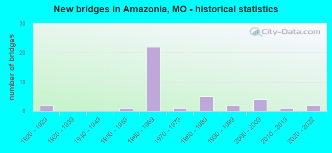
- New bridges - historical statistics
- 21920-1929
- 11950-1959
- 221960-1969
- 11970-1979
- 51980-1989
- 21990-1999
- 42000-2009
- 12010-2019
- 22020-2022

- Reconstructed bridges - Historical Statistics
- 71980-1989
- 21990-1999


- Bridge Condition - Deck
- 10.0%Excellent
- 20.0%Very good
- 35.0%Good
- 20.0%Satisfactory
- 15.0%Fair

- Bridge Condition - Superstructure
- 15.0%Excellent
- 15.0%Very good
- 45.0%Good
- 10.0%Satisfactory
- 10.0%Fair
- 5.0%Poor

- Bridge Condition - Substructure
- 15.0%Excellent
- 30.0%Very good
- 25.0%Good
- 25.0%Satisfactory
- 5.0%Fair

- Bridge Condition - Channel
- 5.9%Good
- 70.6%Satisfactory
- 17.6%Fair
- 5.9%Poor

- Bridge Condition - Culverts
- 75.0%Satisfactory
- 25.0%Poor
Find on map >> Show street view
Structure Number: 1062, Location: S 15 T 59 N R 36 W (Lat: 39.936831, Lng: -94.932131), Route carried "on" structure: Interstate 29, Year Built: 1966, Year Reconstructed: 1991, Status: Open, Structure Length: 7.41m (24.31ft), Average Daily Traffic: 14,981 (year 2021), Truck Traffic: 34%, Average Future Daily Traffic: 31,460 (year 2041), Design Load: HS 20, Features Intersected: CRD 404, MILL CR
Minimum Vertical Clearance: 30+ m (98+ ft), Kilometerpoint: 99.588, Lanes on structure: 2, Lanes under structure: 2, Base Highway Network: Yes, Owner: State Highway Agency, Approaching Roadway Width: 11.6m (38.1ft), Skew: 22 degrees, Material/Design: Steel continuous, Design/Construction: Stringer/Multi-beam, Number Of Spans In Main Unit: 4, Length of Maximum Span: 21.0m (68.9ft), Curb-To-Curb Width: 11.4m (37.4ft), Out-to-Out Width: 12.2m (40.0ft)
Condition: Deck: Fair, Superstructure: Good, Substructure: Very good, Channel: Satisfactory, Operating Rating: 51.3 metric tons, Method Used To Determine Operating Rating: Load Factor (LF), Inventory Rating: 30.6 metric tons, Method Used To Determine Inventory Rating: Load Factor (LF), Structural Evaluation: Better than present minimum criteria, Deck Geometry: Somewhat better than minimum adequacy, Underclear: Better than present minimum criteria, Waterway Adequacy: Equal to present minimum criteria, Approach Roadway Alignment: Equal to present desirable criteria, Designated Inspection Frequency: Every 24 months, Inspection Date: September 2020, Deck Structure Type: Concrete Cast-file-Place, Wearing Surface/Protective System: Wearing Surface: Epoxy Overlay
Find on map >> Show street view
Structure Number: 1063, Location: S 15 T 59 N R 36 W (Lat: 39.937050, Lng: -94.931931), Route carried "on" structure: Interstate 29, Year Built: 1966, Year Reconstructed: 1991, Status: Open, Structure Length: 7.41m (24.31ft), Average Daily Traffic: 9,004 (year 2021), Truck Traffic: 36%, Average Future Daily Traffic: 18,908 (year 2041), Design Load: HS 20, Features Intersected: CRD 404, MILL CR
Minimum Vertical Clearance: 30+ m (98+ ft), Kilometerpoint: 107.509, Lanes on structure: 2, Lanes under structure: 2, Base Highway Network: Yes, Owner: State Highway Agency, Approaching Roadway Width: 11.6m (38.1ft), Skew: 22 degrees, Material/Design: Steel continuous, Design/Construction: Stringer/Multi-beam, Number Of Spans In Main Unit: 4, Length of Maximum Span: 21.0m (68.9ft), Curb-To-Curb Width: 11.4m (37.4ft), Out-to-Out Width: 12.2m (40.0ft)
Condition: Deck: Fair, Superstructure: Good, Substructure: Good, Channel: Satisfactory, Operating Rating: 51.3 metric tons, Method Used To Determine Operating Rating: Load Factor (LF), Inventory Rating: 30.6 metric tons, Method Used To Determine Inventory Rating: Load Factor (LF), Structural Evaluation: Better than present minimum criteria, Deck Geometry: Somewhat better than minimum adequacy, Underclear: Equal to present minimum criteria, Waterway Adequacy: Equal to present minimum criteria, Approach Roadway Alignment: Equal to present desirable criteria, Designated Inspection Frequency: Every 24 months, Inspection Date: September 2020, Deck Structure Type: Concrete Cast-file-Place, Wearing Surface/Protective System: Wearing Surface: Epoxy Overlay
Find on map >> Show street view
Structure Number: 1065, Location: S 25 T 59 N R 35 W (Lat: 39.903667, Lng: -94.884867), Route carried "on" structure: Interstate 29, Year Built: 1965, Year Reconstructed: 1991, Status: Open, Structure Length: 3.20m (10.50ft), Average Daily Traffic: 12,862 (year 2021), Truck Traffic: 34%, Average Future Daily Traffic: 27,010 (year 2041), Design Load: HS 20+Mod, Features Intersected: RT T
Minimum Vertical Clearance: 30+ m (98+ ft), Kilometerpoint: 105.086, Lanes on structure: 2, Lanes under structure: 2, Base Highway Network: Yes, Owner: State Highway Agency, Approaching Roadway Width: 11.6m (38.1ft), Skew: 20 degrees, Material/Design: Concrete continuous, Design/Construction: Slab, Number Of Spans In Main Unit: 3, Length of Maximum Span: 13.7m (44.9ft), Curb-To-Curb Width: 11.4m (37.4ft), Out-to-Out Width: 12.2m (40.0ft)
Condition: Deck: Very good, Superstructure: Very good, Substructure: Good, Operating Rating: 67.5 metric tons, Method Used To Determine Operating Rating: Load Factor (LF), Inventory Rating: 40.5 metric tons, Method Used To Determine Inventory Rating: Load Factor (LF), Structural Evaluation: Better than present minimum criteria, Deck Geometry: Somewhat better than minimum adequacy, Underclear: Somewhat better than minimum adequacy, Approach Roadway Alignment: Equal to present desirable criteria, Designated Inspection Frequency: Every 24 months, Inspection Date: March 2021, Deck Structure Type: Concrete Cast-file-Place, Wearing Surface/Protective System: Wearing Surface: Latex Concrete
Find on map >> Show street view
Structure Number: 1066, Location: S 25 T 59 N R 35 W (Lat: 39.903839, Lng: -94.884683), Route carried "on" structure: Interstate 29, Year Built: 1965, Year Reconstructed: 1991, Status: Open, Structure Length: 3.20m (10.50ft), Average Daily Traffic: 8,626 (year 2021), Truck Traffic: 36%, Average Future Daily Traffic: 18,115 (year 2041), Design Load: HS 20+Mod, Features Intersected: RT T
Minimum Vertical Clearance: 30+ m (98+ ft), Kilometerpoint: 102.054, Lanes on structure: 2, Lanes under structure: 2, Base Highway Network: Yes, Owner: State Highway Agency, Approaching Roadway Width: 11.6m (38.1ft), Skew: 20 degrees, Material/Design: Concrete continuous, Design/Construction: Slab, Number Of Spans In Main Unit: 3, Length of Maximum Span: 13.7m (44.9ft), Curb-To-Curb Width: 11.4m (37.4ft), Out-to-Out Width: 12.2m (40.0ft)
Condition: Deck: Very good, Superstructure: Very good, Substructure: Good, Operating Rating: 67.5 metric tons, Method Used To Determine Operating Rating: Load Factor (LF), Inventory Rating: 40.5 metric tons, Method Used To Determine Inventory Rating: Load Factor (LF), Structural Evaluation: Better than present minimum criteria, Deck Geometry: Somewhat better than minimum adequacy, Underclear: Meets minimum limits, Approach Roadway Alignment: Equal to present desirable criteria, Designated Inspection Frequency: Every 24 months, Inspection Date: March 2021, Deck Structure Type: Concrete Cast-file-Place, Wearing Surface/Protective System: Wearing Surface: Latex Concrete
Find on map >> Show street view
Structure Number: 23266, Location: S 27 T 59 N R 36 W (Lat: 39.899800, Lng: -94.922953), Route carried "on" structure: County highway 399, Year Built: 1925, Status: Posted for load, Structure Length: 2.16m (7.09ft), Average Daily Traffic: 30 (year 2020), Truck Traffic: 10%, Average Future Daily Traffic: 35 (year 2040), Features Intersected: MILL CR
Minimum Vertical Clearance: 30+ m (98+ ft), Kilometerpoint: 0.966, Lanes on structure: 2, Owner: County Highway Agency, Approaching Roadway Width: 5.5m (18.0ft), Material/Design: Steel, Design/Construction: Truss - Thru, Number Of Spans In Main Unit: 1, Length of Maximum Span: 21.3m (69.9ft), Curb-To-Curb Width: 5.5m (18.0ft), Out-to-Out Width: 5.9m (19.4ft)
Condition: Deck: Satisfactory, Superstructure: Poor, Substructure: Good, Channel: Satisfactory, Operating Rating: 20.7 metric tons, Method Used To Determine Operating Rating: Load Factor (LF), Inventory Rating: 12.6 metric tons, Method Used To Determine Inventory Rating: Load Factor (LF), Structural Evaluation: Meets minimum limits, Deck Geometry: Meets minimum limits, Waterway Adequacy: Superior to present desirable criteria, Approach Roadway Alignment: Equal to present minimum criteria, Bridge Posting: Required (Relationship of Operating Rating to Maximum Legal Load: 30.0 - 39.9% below), Length Of Structure Improvement: 0.30m (0.98ft), Designated Inspection Frequency: Every 24 months, Critical Feature Inspection Frequency: Every 24 months, Inspection Date: December 2021, Critical Feature Inspection Date: December 2021, Bridge Improvement Cost: $218,000, Roadway Improvement Cost: $22,000, Total Project Cost: $326,000 ( Estimate for 2022), Deck Structure Type: Concrete Cast-file-Place, Wearing Surface/Protective System: Wearing Surface: Monolithic Concrete
Find on map >> Show street view
Structure Number: 23483, Location: S 15 T 59 N R 36 W (Lat: 39.935658, Lng: -94.932136), Route carried "on" structure: County highway 410, Year Built: 1970, Status: Open, Structure Length: 0.85m (2.79ft), Average Daily Traffic: 10 (year 2020), Truck Traffic: 10%, Average Future Daily Traffic: 12 (year 2040), Features Intersected: MILL CR
Minimum Vertical Clearance: 30+ m (98+ ft), Kilometerpoint: 0.161, Lanes on structure: 1, Owner: County Highway Agency, Approaching Roadway Width: 7.3m (24.0ft), Material/Design: Concrete, Design/Construction: Culvert, Number Of Spans In Main Unit: 2, Length of Maximum Span: 4.0m (13.1ft)
Condition: Channel: Satisfactory, Culverts: Satisfactory, Operating Rating: 49.5 metric tons, Method Used To Determine Operating Rating: Allowable Stress (AS), Inventory Rating: 16.2 metric tons, Method Used To Determine Inventory Rating: Allowable Stress (AS), Structural Evaluation: Somewhat better than minimum adequacy, Waterway Adequacy: Superior to present desirable criteria, Approach Roadway Alignment: High priority of corrective action, Length Of Structure Improvement: 0.15m (0.49ft), Designated Inspection Frequency: Every 24 months, Inspection Date: December 2021, Bridge Improvement Cost: $85,000, Roadway Improvement Cost: $9,000, Total Project Cost: $128,000 ( Estimate for 2022)
Find on map >> Show street view
Structure Number: 23496, Location: S 27 T 59 N R 36 W (Lat: 39.907744, Lng: -94.928089), Route carried "on" structure: County highway 410, Year Built: 1920, Year Reconstructed: 1999, Status: Open, Structure Length: 2.07m (6.79ft), Average Daily Traffic: 25 (year 2020), Truck Traffic: 10%, Average Future Daily Traffic: 29 (year 2040), Features Intersected: MILL CR
Minimum Vertical Clearance: 30+ m (98+ ft), Kilometerpoint: 3.380, Lanes on structure: 1, Owner: County Highway Agency, Approaching Roadway Width: 5.5m (18.0ft), Material/Design: Steel, Design/Construction: Stringer/Multi-beam, Number Of Spans In Main Unit: 1, Number Of Approach Spans: 1, Length of Maximum Span: 12.5m (41.0ft), Curb-To-Curb Width: 4.9m (16.1ft), Out-to-Out Width: 4.9m (16.1ft)
Condition: Deck: Good, Superstructure: Fair, Substructure: Fair, Channel: Fair, Operating Rating: 58.5 metric tons, Method Used To Determine Operating Rating: Load Factor (LF), Inventory Rating: 35.1 metric tons, Method Used To Determine Inventory Rating: Load Factor (LF), Structural Evaluation: Somewhat better than minimum adequacy, Deck Geometry: High priority of corrective action, Waterway Adequacy: Equal to present desirable criteria, Approach Roadway Alignment: Equal to present minimum criteria, Length Of Structure Improvement: 0.28m (0.92ft), Designated Inspection Frequency: Every 24 months, Inspection Date: December 2021, Bridge Improvement Cost: $139,000, Roadway Improvement Cost: $14,000, Total Project Cost: $208,000 ( Estimate for 2022), Deck Structure Type: Concrete Cast-file-Place
Find on map >> Show street view
Structure Number: 23589, Location: S 24 T 59 N R 36 W (Lat: 39.915678, Lng: -94.881544), Route carried "on" structure: County highway 417, Year Built: 1989, Status: Open, Structure Length: 1.07m (3.51ft), Average Daily Traffic: 30 (year 2020), Truck Traffic: 10%, Average Future Daily Traffic: 35 (year 2040), Design Load: HS 20, Features Intersected: MACE CR
Minimum Vertical Clearance: 30+ m (98+ ft), Kilometerpoint: 1.931, Lanes on structure: 2, Owner: County Highway Agency, Approaching Roadway Width: 7.3m (24.0ft), Material/Design: Concrete, Design/Construction: Culvert, Number Of Spans In Main Unit: 2, Length of Maximum Span: 3.7m (12.1ft)
Condition: Channel: Fair, Culverts: Satisfactory, Operating Rating: 58.5 metric tons, Method Used To Determine Operating Rating: Allowable Stress (AS), Inventory Rating: 32.4 metric tons, Method Used To Determine Inventory Rating: Allowable Stress (AS), Structural Evaluation: Equal to present minimum criteria, Waterway Adequacy: Superior to present desirable criteria, Approach Roadway Alignment: High priority of corrective action, Designated Inspection Frequency: Every 24 months, Inspection Date: December 2021
Find on map >> Show street view
Structure Number: 23643, Location: S 10 T 59 N R 36 W (Lat: 39.939553, Lng: -94.929353), Route carried "on" structure: County highway 422, Year Built: 1996, Status: Open, Structure Length: 0.79m (2.59ft), Average Daily Traffic: 35 (year 2020), Truck Traffic: 5%, Average Future Daily Traffic: 40 (year 2040), Features Intersected: MILL CR
Minimum Vertical Clearance: 30+ m (98+ ft), Kilometerpoint: 0.322, Lanes on structure: 2, Owner: County Highway Agency, Approaching Roadway Width: 7.3m (24.0ft), Skew: 1 degrees, Material/Design: Concrete, Design/Construction: Culvert, Number Of Spans In Main Unit: 2, Length of Maximum Span: 3.7m (12.1ft)
Condition: Channel: Poor, Culverts: Poor, Operating Rating: 54.0 metric tons, Method Used To Determine Operating Rating: Load Factor (LF), Inventory Rating: 32.4 metric tons, Method Used To Determine Inventory Rating: Load Factor (LF), Structural Evaluation: Meets minimum limits, Waterway Adequacy: Equal to present desirable criteria, Approach Roadway Alignment: Equal to present minimum criteria, Length Of Structure Improvement: 0.14m (0.46ft), Designated Inspection Frequency: Every 24 months, Inspection Date: December 2021, Bridge Improvement Cost: $85,000, Roadway Improvement Cost: $9,000, Total Project Cost: $128,000 ( Estimate for 2022)
Find on map >> Show street view
Structure Number: 23646, Location: S 10 T 59 N R 36 W (Lat: 39.939372, Lng: -94.923958), Route carried "on" structure: County highway 422, Year Built: 1998, Status: Open, Structure Length: 0.70m (2.30ft), Average Daily Traffic: 100 (year 2020), Truck Traffic: 10%, Average Future Daily Traffic: 115 (year 2040), Design Load: HS 20, Features Intersected: MILL CR
Minimum Vertical Clearance: 30+ m (98+ ft), Kilometerpoint: 0.805, Lanes on structure: 2, Owner: County Highway Agency, Approaching Roadway Width: 7.3m (24.0ft), Skew: 2 degrees, Material/Design: Concrete continuous, Design/Construction: Culvert, Number Of Spans In Main Unit: 2, Length of Maximum Span: 3.4m (11.2ft)
Condition: Channel: Fair, Culverts: Satisfactory, Structural Evaluation: Equal to present minimum criteria, Waterway Adequacy: Superior to present desirable criteria, Approach Roadway Alignment: Equal to present minimum criteria, Designated Inspection Frequency: Every 24 months, Inspection Date: December 2021
Find on map >> Show street view
Structure Number: 2724, Location: S 29 T 59 N R 35 W (Lat: 39.899028, Lng: -94.857206), Route carried "on" structure: County highway 369, Year Built: 1985, Status: Open, Structure Length: 8.02m (26.31ft), Average Daily Traffic: 60 (year 2021), Truck Traffic: 10%, Average Future Daily Traffic: 78 (year 2041), Design Load: H 20, Features Intersected: US 59
Minimum Vertical Clearance: 30+ m (98+ ft), Kilometerpoint: 1.259, Lanes on structure: 2, Lanes under structure: 4, Owner: State Highway Agency, Approaching Roadway Width: 8.5m (27.9ft), Skew: 1 degrees, Material/Design: Steel continuous, Design/Construction: Stringer/Multi-beam, Number Of Spans In Main Unit: 2, Length of Maximum Span: 34.7m (113.8ft), Curb or Sidewalk Widths: Left: 0.2m (0.7ft), Right: 0.2m (0.7ft), Curb-To-Curb Width: 8.2m (26.9ft), Out-to-Out Width: 9.0m (29.5ft)
Condition: Deck: Good, Superstructure: Good, Substructure: Very good, Operating Rating: 41.4 metric tons, Method Used To Determine Operating Rating: Allowable Stress (AS), Inventory Rating: 26.1 metric tons, Method Used To Determine Inventory Rating: Allowable Stress (AS), Structural Evaluation: Equal to present minimum criteria, Deck Geometry: Equal to present minimum criteria, Underclear: Equal to present desirable criteria, Approach Roadway Alignment: Equal to present minimum criteria, Designated Inspection Frequency: Every 24 months, Inspection Date: September 2020, Deck Structure Type: Concrete Cast-file-Place, Wearing Surface/Protective System: Wearing Surface: Monolithic Concrete, Deck Protection: Internally Sealed
Find on map >> Show street view
Structure Number: 29516, Location: S 7 T 58 N R 35 W (Lat: 39.860011, Lng: -94.880047), Route carried "on" structure: State highway K, Year Built: 2003, Status: Open, Structure Length: 4.83m (15.85ft), Average Daily Traffic: 1,660 (year 2021), Truck Traffic: 5%, Average Future Daily Traffic: 2,158 (year 2041), Design Load: HS 20, Features Intersected: DILLION CR
Minimum Vertical Clearance: 30+ m (98+ ft), Kilometerpoint: 7.401, Lanes on structure: 2, Owner: State Highway Agency, Approaching Roadway Width: 12.2m (40.0ft), Skew: 3 degrees, Material/Design: Prestressed concrete continuous, Design/Construction: Stringer/Multi-beam, Number Of Spans In Main Unit: 3, Length of Maximum Span: 19.8m (65.0ft), Curb-To-Curb Width: 12.2m (40.0ft), Out-to-Out Width: 13.0m (42.7ft)
Condition: Deck: Satisfactory, Superstructure: Good, Substructure: Very good, Channel: Satisfactory, Operating Rating: 69.3 metric tons, Method Used To Determine Operating Rating: Load Factor (LF), Inventory Rating: 41.4 metric tons, Method Used To Determine Inventory Rating: Load Factor (LF), Structural Evaluation: Better than present minimum criteria, Deck Geometry: Better than present minimum criteria, Waterway Adequacy: Superior to present desirable criteria, Approach Roadway Alignment: Equal to present desirable criteria, Designated Inspection Frequency: Every 24 months, Inspection Date: September 2020, Deck Structure Type: Concrete Cast-file-Place, Wearing Surface/Protective System: Wearing Surface: Monolithic Concrete, Deck Protection: Epoxy Coated Reinforcing
Find on map >> Show street view
Structure Number: 29518, Location: S 36 T 59 N R 36 W (Lat: 39.885653, Lng: -94.891375), Route carried "on" structure: State highway K, Year Built: 2003, Status: Open, Structure Length: 9.83m (32.25ft), Average Daily Traffic: 1,660 (year 2021), Truck Traffic: 5%, Average Future Daily Traffic: 2,158 (year 2041), Design Load: HS 20, Features Intersected: CAPLES CR
Minimum Vertical Clearance: 30+ m (98+ ft), Kilometerpoint: 4.197, Lanes on structure: 2, Owner: State Highway Agency, Approaching Roadway Width: 12.2m (40.0ft), Skew: 1 degrees, Material/Design: Steel continuous, Design/Construction: Stringer/Multi-beam, Number Of Spans In Main Unit: 3, Length of Maximum Span: 36.6m (120.1ft), Curb-To-Curb Width: 12.2m (40.0ft), Out-to-Out Width: 13.0m (42.7ft)
Condition: Deck: Good, Superstructure: Good, Substructure: Very good, Channel: Satisfactory, Operating Rating: 62.1 metric tons, Method Used To Determine Operating Rating: Load Factor (LF), Inventory Rating: 37.8 metric tons, Method Used To Determine Inventory Rating: Load Factor (LF), Structural Evaluation: Better than present minimum criteria, Deck Geometry: Better than present minimum criteria, Waterway Adequacy: Superior to present desirable criteria, Approach Roadway Alignment: Equal to present desirable criteria, Designated Inspection Frequency: Every 24 months, Inspection Date: September 2020, Deck Structure Type: Concrete Cast-file-Place, Wearing Surface/Protective System: Wearing Surface: Monolithic Concrete, Deck Protection: Epoxy Coated Reinforcing
Find on map >> Show street view
Structure Number: 30529, Location: S 7 T 58 N R 35 W (Lat: 39.858811, Lng: -94.867708), Route carried "on" structure: County highway 375, Year Built: 2004, Status: Open, Structure Length: 3.69m (12.11ft), Average Daily Traffic: 50 (year 2020), Truck Traffic: 10%, Average Future Daily Traffic: 58 (year 2040), Design Load: HS 20, Features Intersected: DILLON CR
Minimum Vertical Clearance: 30+ m (98+ ft), Kilometerpoint: 1.127, Lanes on structure: 2, Owner: County Highway Agency, Approaching Roadway Width: 6.7m (22.0ft), Material/Design: Prestressed concrete continuous, Design/Construction: Stringer/Multi-beam, Number Of Spans In Main Unit: 3, Length of Maximum Span: 12.2m (40.0ft), Curb-To-Curb Width: 6.7m (22.0ft), Out-to-Out Width: 7.5m (24.6ft)
Condition: Deck: Good, Superstructure: Excellent, Substructure: Good, Channel: Satisfactory, Operating Rating: 55.8 metric tons, Method Used To Determine Operating Rating: Load Factor (LF), Inventory Rating: 33.3 metric tons, Method Used To Determine Inventory Rating: Load Factor (LF), Structural Evaluation: Better than present minimum criteria, Deck Geometry: Somewhat better than minimum adequacy, Waterway Adequacy: Equal to present desirable criteria, Approach Roadway Alignment: Equal to present desirable criteria, Designated Inspection Frequency: Every 24 months, Inspection Date: December 2021, Deck Structure Type: Concrete Precast Panels, Wearing Surface/Protective System: Wearing Surface: Monolithic Concrete
Find on map >> Show street view
Structure Number: 3053, Location: S 24 T 59 N R 36 W (Lat: 39.921406, Lng: -94.889136), Route carried "on" structure: County highway 418, Year Built: 2004, Status: Open, Structure Length: 4.51m (14.80ft), Average Daily Traffic: 30 (year 2020), Truck Traffic: 10%, Average Future Daily Traffic: 35 (year 2040), Design Load: HS 20, Features Intersected: CAPLES CR
Minimum Vertical Clearance: 30+ m (98+ ft), Kilometerpoint: 1.287, Lanes on structure: 2, Owner: County Highway Agency, Approaching Roadway Width: 6.7m (22.0ft), Skew: 2 degrees, Material/Design: Prestressed concrete continuous, Design/Construction: Stringer/Multi-beam, Number Of Spans In Main Unit: 3, Length of Maximum Span: 21.9m (71.9ft), Curb-To-Curb Width: 6.7m (22.0ft), Out-to-Out Width: 7.5m (24.6ft)
Condition: Deck: Very good, Superstructure: Very good, Substructure: Excellent, Channel: Satisfactory, Operating Rating: 62.1 metric tons, Method Used To Determine Operating Rating: Load Factor (LF), Inventory Rating: 32.4 metric tons, Method Used To Determine Inventory Rating: Load Factor (LF), Structural Evaluation: Equal to present desirable criteria, Deck Geometry: Somewhat better than minimum adequacy, Waterway Adequacy: Superior to present desirable criteria, Approach Roadway Alignment: Equal to present desirable criteria, Designated Inspection Frequency: Every 24 months, Inspection Date: December 2021, Deck Structure Type: Concrete Precast Panels, Wearing Surface/Protective System: Wearing Surface: Monolithic Concrete
Find on map >> Show street view
Structure Number: 34167, Location: S 12 T 58 N R 36 W (Lat: 39.860117, Lng: -94.881264), Route carried "on" structure: County highway 392, Year Built: 2012, Status: Open, Structure Length: 3.70m (12.14ft), Average Daily Traffic: 40 (year 2020), Truck Traffic: 10%, Average Future Daily Traffic: 46 (year 2040), Features Intersected: MACE CR
Minimum Vertical Clearance: 30+ m (98+ ft), Kilometerpoint: 0.000, Lanes on structure: 2, Owner: County Highway Agency, Approaching Roadway Width: 6.1m (20.0ft), Material/Design: Prestressed concrete continuous, Design/Construction: Tee Beam, Number Of Spans In Main Unit: 3, Length of Maximum Span: 12.2m (40.0ft), Curb-To-Curb Width: 7.3m (24.0ft), Out-to-Out Width: 8.2m (26.9ft)
Condition: Deck: Very good, Superstructure: Good, Substructure: Very good, Channel: Good, Operating Rating: 60.3 metric tons, Method Used To Determine Operating Rating: Load and Resistance Factor (LRFR), Inventory Rating: 36.0 metric tons, Method Used To Determine Inventory Rating: Load and Resistance Factor (LRFR), Structural Evaluation: Better than present minimum criteria, Deck Geometry: Equal to present minimum criteria, Waterway Adequacy: Equal to present desirable criteria, Approach Roadway Alignment: Equal to present desirable criteria, Designated Inspection Frequency: Every 24 months, Inspection Date: December 2021, Deck Structure Type: Concrete Precast Panels, Wearing Surface/Protective System: Wearing Surface: Monolithic Concrete
Find on map >> Show street view
Structure Number: 3539, Location: S 30 T 59 N R 36 W (Lat: 39.906444, Lng: -94.880078), Route carried "on" structure: State highway T, Year Built: 1987, Status: Open, Structure Length: 3.14m (10.30ft), Average Daily Traffic: 833 (year 2021), Truck Traffic: 13%, Average Future Daily Traffic: 1,083 (year 2041), Design Load: HS 20, Features Intersected: MACE CR
Minimum Vertical Clearance: 30+ m (98+ ft), Kilometerpoint: 9.906, Lanes on structure: 2, Owner: State Highway Agency, Approaching Roadway Width: 6.1m (20.0ft), Material/Design: Prestressed concrete continuous, Design/Construction: Tee Beam, Number Of Spans In Main Unit: 3, Length of Maximum Span: 12.8m (42.0ft), Curb or Sidewalk Widths: Left: 0.2m (0.7ft), Right: 0.2m (0.7ft), Curb-To-Curb Width: 10.0m (32.8ft), Out-to-Out Width: 10.8m (35.4ft)
Condition: Deck: Good, Superstructure: Good, Substructure: Satisfactory, Channel: Satisfactory, Operating Rating: 84.6 metric tons, Method Used To Determine Operating Rating: Allowable Stress (AS), Inventory Rating: 52.2 metric tons, Method Used To Determine Inventory Rating: Allowable Stress (AS), Structural Evaluation: Equal to present minimum criteria, Deck Geometry: Equal to present minimum criteria, Waterway Adequacy: Equal to present desirable criteria, Approach Roadway Alignment: Equal to present desirable criteria, Designated Inspection Frequency: Every 24 months, Inspection Date: September 2020, Deck Structure Type: Concrete Cast-file-Place, Wearing Surface/Protective System: Wearing Surface: Monolithic Concrete, Deck Protection: Epoxy Coated Reinforcing
Find on map >> Show street view
Structure Number: 36226, Location: S 25 T 59 N R 36 W (Lat: 39.901819, Lng: -94.881419), Route carried "on" structure: Interstate 29, Year Built: 2020, Status: Open, Structure Length: 11.84m (38.85ft), Average Daily Traffic: 8,626 (year 2021), Truck Traffic: 36%, Average Future Daily Traffic: 18,115 (year 2041), Features Intersected: HOPKINS & MACE CR
Minimum Vertical Clearance: 30+ m (98+ ft), Kilometerpoint: 101.653, Lanes on structure: 2, Base Highway Network: Yes, Owner: State Highway Agency, Approaching Roadway Width: 11.6m (38.1ft), Material/Design: Prestressed concrete continuous, Design/Construction: Stringer/Multi-beam, Number Of Spans In Main Unit: 4, Length of Maximum Span: 30.5m (100.1ft), Curb-To-Curb Width: 11.6m (38.1ft), Out-to-Out Width: 12.4m (40.7ft)
Condition: Deck: Excellent, Superstructure: Excellent, Substructure: Excellent, Channel: Satisfactory, Operating Rating: 81.9 metric tons, Method Used To Determine Operating Rating: Load Factor (LF), Inventory Rating: 42.3 metric tons, Method Used To Determine Inventory Rating: Load Factor (LF), Structural Evaluation: Superior to present desirable criteria, Deck Geometry: Equal to present minimum criteria, Waterway Adequacy: Superior to present desirable criteria, Approach Roadway Alignment: Equal to present desirable criteria, Designated Inspection Frequency: Every 24 months, Inspection Date: November 2021, Deck Structure Type: Concrete Cast-file-Place, Wearing Surface/Protective System: Wearing Surface: Monolithic Concrete, Deck Protection: Epoxy Coated Reinforcing
Find on map >> Show street view
Structure Number: 36228, Location: S 25 T 59 N R 36 W (Lat: 39.901722, Lng: -94.881753), Route carried "on" structure: Interstate 29, Year Built: 2020, Status: Open, Structure Length: 11.05m (36.25ft), Average Daily Traffic: 12,862 (year 2021), Truck Traffic: 34%, Average Future Daily Traffic: 27,010 (year 2041), Features Intersected: HOPKINS & MACE CR
Minimum Vertical Clearance: 30+ m (98+ ft), Kilometerpoint: 105.390, Lanes on structure: 2, Base Highway Network: Yes, Owner: State Highway Agency, Approaching Roadway Width: 11.6m (38.1ft), Material/Design: Prestressed concrete continuous, Design/Construction: Stringer/Multi-beam, Number Of Spans In Main Unit: 4, Length of Maximum Span: 30.5m (100.1ft), Curb-To-Curb Width: 11.6m (38.1ft), Out-to-Out Width: 12.4m (40.7ft)
Condition: Deck: Excellent, Superstructure: Excellent, Substructure: Excellent, Channel: Satisfactory, Operating Rating: 82.8 metric tons, Method Used To Determine Operating Rating: Load Factor (LF), Inventory Rating: 41.4 metric tons, Method Used To Determine Inventory Rating: Load Factor (LF), Structural Evaluation: Superior to present desirable criteria, Deck Geometry: Equal to present minimum criteria, Waterway Adequacy: Superior to present desirable criteria, Approach Roadway Alignment: Equal to present desirable criteria, Designated Inspection Frequency: Every 24 months, Inspection Date: November 2021, Deck Structure Type: Concrete Cast-file-Place, Wearing Surface/Protective System: Wearing Surface: Monolithic Concrete, Deck Protection: Epoxy Coated Reinforcing
Find on map >> Show street view
Structure Number: 7977, Location: S 27 T 59 N R 36 W (Lat: 39.899706, Lng: -94.927081), Route carried "on" structure: State highway T, Year Built: 1956, Year Reconstructed: 2002, Status: Open, Structure Length: 4.48m (14.70ft), Average Daily Traffic: 674 (year 2021), Truck Traffic: 6%, Average Future Daily Traffic: 876 (year 2041), Design Load: H 10, Features Intersected: MILL CR
Minimum Vertical Clearance: 30+ m (98+ ft), Kilometerpoint: 3.697, Lanes on structure: 2, Owner: State Highway Agency, Approaching Roadway Width: 6.7m (22.0ft), Material/Design: Steel, Design/Construction: Stringer/Multi-beam, Number Of Spans In Main Unit: 3, Length of Maximum Span: 16.8m (55.1ft), Curb-To-Curb Width: 6.7m (22.0ft), Out-to-Out Width: 7.7m (25.3ft)
Condition: Deck: Good, Superstructure: Good, Substructure: Satisfactory, Channel: Satisfactory, Operating Rating: 40.5 metric tons, Method Used To Determine Operating Rating: Load Factor (LF), Inventory Rating: 24.3 metric tons, Method Used To Determine Inventory Rating: Load Factor (LF), Structural Evaluation: Equal to present minimum criteria, Deck Geometry: Meets minimum limits, Waterway Adequacy: Better than present minimum criteria, Approach Roadway Alignment: Equal to present desirable criteria, Designated Inspection Frequency: Every 24 months, Inspection Date: September 2020, Deck Structure Type: Concrete Cast-file-Place, Wearing Surface/Protective System: Wearing Surface: Monolithic Concrete, Deck Protection: Epoxy Coated Reinforcing
Find on map >> Show street view
Structure Number: 8369, Location: S 31 T 59 N R 35 W (Lat: 39.893231, Lng: -94.867594), Route carried "on" structure: County highway 369, Year Built: 1965, Status: Open, Structure Length: 7.35m (24.11ft), Average Daily Traffic: 60 (year 2021), Truck Traffic: 10%, Average Future Daily Traffic: 78 (year 2041), Design Load: H 15, Features Intersected: IS 29
Minimum Vertical Clearance: 30+ m (98+ ft), Kilometerpoint: 0.031, Lanes on structure: 2, Lanes under structure: 4, Owner: State Highway Agency, Approaching Roadway Width: 6.1m (20.0ft), Skew: 1 degrees, Material/Design: Concrete continuous, Design/Construction: Slab, Number Of Spans In Main Unit: 4, Length of Maximum Span: 20.7m (67.9ft), Curb-To-Curb Width: 7.9m (25.9ft), Out-to-Out Width: 8.7m (28.5ft)
Condition: Deck: Good, Superstructure: Good, Substructure: Very good, Operating Rating: 33.3 metric tons, Method Used To Determine Operating Rating: Allowable Stress (AS), Inventory Rating: 13.5 metric tons, Method Used To Determine Inventory Rating: Allowable Stress (AS), Structural Evaluation: Meets minimum limits, Deck Geometry: Equal to present minimum criteria, Underclear: Meets minimum limits, Approach Roadway Alignment: Equal to present desirable criteria, Designated Inspection Frequency: Every 24 months, Inspection Date: September 2020, Deck Structure Type: Concrete Cast-file-Place, Wearing Surface/Protective System: Wearing Surface: Monolithic Concrete
Find on map >> Show street view
Structure Number: 989, Location: S 32 T 59 N R 35 W (Lat: 39.887292, Lng: -94.857875), Route carried "on" structure: Interstate 29, Year Built: 1965, Year Reconstructed: 1986, Status: Open, Structure Length: 6.83m (22.41ft), Average Daily Traffic: 8,626 (year 2021), Truck Traffic: 36%, Average Future Daily Traffic: 18,115 (year 2041), Design Load: HS 20+Mod, Features Intersected: RP IS29N TO IS229S, US 5
Minimum Vertical Clearance: 30+ m (98+ ft), Kilometerpoint: 99.102, Lanes on structure: 2, Lanes under structure: 4, Base Highway Network: Yes, Owner: State Highway Agency, Approaching Roadway Width: 11.6m (38.1ft), Skew: 22 degrees, Material/Design: Concrete continuous, Design/Construction: Slab, Number Of Spans In Main Unit: 4, Length of Maximum Span: 19.8m (65.0ft), Curb-To-Curb Width: 14.2m (46.6ft), Out-to-Out Width: 14.9m (48.9ft)
Condition: Deck: Fair, Superstructure: Fair, Substructure: Satisfactory, Operating Rating: 55.8 metric tons, Method Used To Determine Operating Rating: Load Factor (LF), Inventory Rating: 33.3 metric tons, Method Used To Determine Inventory Rating: Load Factor (LF), Structural Evaluation: Somewhat better than minimum adequacy, Deck Geometry: Superior to present desirable criteria, Underclear: Meets minimum limits, Approach Roadway Alignment: Equal to present desirable criteria, Designated Inspection Frequency: Every 24 months, Inspection Date: September 2020, Deck Structure Type: Concrete Cast-file-Place, Wearing Surface/Protective System: Wearing Surface: Low Slump Concrete, Membrane: Built-up
Find on map >> Show street view
Structure Number: 99, Location: S 32 T 59 N R 35 W (Lat: 39.886181, Lng: -94.856069), Route carried "on" structure: Interstate 29, Year Built: 1965, Year Reconstructed: 1986, Status: Open, Structure Length: 11.43m (37.50ft), Average Daily Traffic: 8,379 (year 2021), Truck Traffic: 36%, Average Future Daily Traffic: 17,596 (year 2041), Design Load: HS 20+Mod, Features Intersected: RP IS229N TO US59N
Minimum Vertical Clearance: 30+ m (98+ ft), Kilometerpoint: 98.853, Lanes on structure: 2, Lanes under structure: 2, Base Highway Network: Yes, Owner: State Highway Agency, Approaching Roadway Width: 11.6m (38.1ft), Skew: 24 degrees, Material/Design: Concrete continuous, Design/Construction: Box Beam or Girders - Single/Spread, Number Of Spans In Main Unit: 3, Length of Maximum Span: 23.2m (76.1ft), Curb-To-Curb Width: 12.2m (40.0ft), Out-to-Out Width: 12.2m (40.0ft)
Condition: Deck: Satisfactory, Superstructure: Satisfactory, Substructure: Satisfactory, Operating Rating: 60.3 metric tons, Method Used To Determine Operating Rating: Load Factor (LF), Inventory Rating: 36.0 metric tons, Method Used To Determine Inventory Rating: Load Factor (LF), Structural Evaluation: Equal to present minimum criteria, Deck Geometry: Better than present minimum criteria, Underclear: Meets minimum limits, Approach Roadway Alignment: Equal to present desirable criteria, Designated Inspection Frequency: Every 24 months, Inspection Date: September 2020, Deck Structure Type: Concrete Cast-file-Place, Wearing Surface/Protective System: Wearing Surface: Low Slump Concrete, Membrane: Built-up
Find on map >> Show street view
Structure Number: 991, Location: S 32 T 59 N R 35 W (Lat: 39.886211, Lng: -94.858419), Route carried "on" structure: Interstate 29, Year Built: 1965, Year Reconstructed: 1986, Status: Open, Structure Length: 6.37m (20.90ft), Average Daily Traffic: 12,163 (year 2021), Truck Traffic: 34%, Average Future Daily Traffic: 25,542 (year 2041), Design Load: HS 20+Mod, Features Intersected: RP IS29N TO IS229S
Minimum Vertical Clearance: 30+ m (98+ ft), Kilometerpoint: 108.052, Lanes on structure: 2, Lanes under structure: 2, Base Highway Network: Yes, Owner: State Highway Agency, Approaching Roadway Width: 11.6m (38.1ft), Skew: 25 degrees, Material/Design: Concrete continuous, Design/Construction: Box Beam or Girders - Single/Spread, Number Of Spans In Main Unit: 3, Length of Maximum Span: 24.1m (79.1ft), Curb-To-Curb Width: 11.4m (37.4ft), Out-to-Out Width: 12.3m (40.4ft)
Condition: Deck: Satisfactory, Superstructure: Satisfactory, Substructure: Satisfactory, Operating Rating: 59.4 metric tons, Method Used To Determine Operating Rating: Load Factor (LF), Inventory Rating: 36.0 metric tons, Method Used To Determine Inventory Rating: Load Factor (LF), Structural Evaluation: Equal to present minimum criteria, Deck Geometry: Somewhat better than minimum adequacy, Underclear: Somewhat better than minimum adequacy, Approach Roadway Alignment: Equal to present desirable criteria, Designated Inspection Frequency: Every 24 months, Inspection Date: September 2020, Deck Structure Type: Concrete Cast-file-Place, Wearing Surface/Protective System: Wearing Surface: Low Slump Concrete, Membrane: Built-up
Find on map >> Show street view
Structure Number: 1062, Location: S 15 T 59 N R 36 W (Lat: 39.936831, Lng: -94.932131), Route carried "under" structure: County highway 404, Year Built: 1966, Structure Length: 0. m, Average Daily Traffic: 56 (year 2021), Truck Traffic: 11%, Features Intersected: CRD 404, Facility Carried by Structure: IS 29 S
Minimum Vertical Clearance: 4.83m (15.85ft), Kilometerpoint: 5.800, Lanes on structure: 2, Lanes under structure: 2, Material/Design: Steel continuous, Design/Construction: Stringer/Multi-beam, Length of Maximum Span: 21.0m (68.9ft)
Find on map >> Show street view
Structure Number: 1063, Location: S 15 T 59 N R 36 W (Lat: 39.937050, Lng: -94.931931), Route carried "under" structure: County highway 404, Year Built: 1966, Structure Length: 0. m, Average Daily Traffic: 56 (year 2021), Truck Traffic: 11%, Features Intersected: CRD 404, Facility Carried by Structure: IS 29 N
Minimum Vertical Clearance: 4.42m (14.50ft), Kilometerpoint: 5.831, Lanes on structure: 2, Lanes under structure: 2, Material/Design: Steel continuous, Design/Construction: Stringer/Multi-beam, Length of Maximum Span: 21.0m (68.9ft)
Find on map >> Show street view
Structure Number: 1064, Location: S 23 T 59 N R 36 W (Lat: 39.916014, Lng: -94.904556), Route carried "under" structure: Interstate 29, Year Built: 1965, Structure Length: 0. m, Average Daily Traffic: 14,981 (year 2021), Truck Traffic: 34%, Features Intersected: IS 29, Facility Carried by Structure: RT K S
Minimum Vertical Clearance: 4.88m (16.01ft), Kilometerpoint: 102.937, Lanes on structure: 2, Lanes under structure: 2, Material/Design: Concrete continuous, Design/Construction: Box Beam or Girders - Single/Spread, Length of Maximum Span: 28.0m (91.9ft)
Find on map >> Show street view
Structure Number: 1064, Location: S 23 T 59 N R 36 W (Lat: 39.916014, Lng: -94.904556), Route carried "under" structure: Interstate 29, Year Built: 1965, Structure Length: 0. m, Average Daily Traffic: 8,626 (year 2021), Truck Traffic: 36%, Features Intersected: IS 29, Facility Carried by Structure: RT K S
Minimum Vertical Clearance: 4.88m (16.01ft), Kilometerpoint: 104.253, Lanes on structure: 2, Lanes under structure: 2, Material/Design: Concrete continuous, Design/Construction: Box Beam or Girders - Single/Spread, Length of Maximum Span: 28.0m (91.9ft)
Find on map >> Show street view
Structure Number: 1065, Location: S 25 T 59 N R 35 W (Lat: 39.903667, Lng: -94.884867), Route carried "under" structure: State highway T, Year Built: 1965, Structure Length: 0. m, Average Daily Traffic: 833 (year 2021), Truck Traffic: 13%, Features Intersected: RT T, Facility Carried by Structure: IS 29 S
Minimum Vertical Clearance: 4.57m (14.99ft), Kilometerpoint: 9.399, Lanes on structure: 2, Lanes under structure: 2, Material/Design: Concrete continuous, Design/Construction: Slab, Length of Maximum Span: 13.7m (44.9ft)
Find on map >> Show street view
Structure Number: 1066, Location: S 25 T 59 N R 35 W (Lat: 39.903839, Lng: -94.884683), Route carried "under" structure: State highway T, Year Built: 1965, Structure Length: 0. m, Average Daily Traffic: 833 (year 2021), Truck Traffic: 13%, Features Intersected: RT T, Facility Carried by Structure: IS 29 N
Minimum Vertical Clearance: 4.47m (14.67ft), Kilometerpoint: 9.423, Lanes on structure: 2, Lanes under structure: 2, Material/Design: Concrete continuous, Design/Construction: Slab, Length of Maximum Span: 13.7m (44.9ft)
Find on map >> Show street view
Structure Number: 2724, Location: S 29 T 59 N R 35 W (Lat: 39.899028, Lng: -94.857206), Route carried "under" structure: US 59, Year Built: 1985, Structure Length: 0. m, Average Daily Traffic: 4,239 (year 2021), Truck Traffic: 24%, Features Intersected: US 59, Facility Carried by Structure: 369 E
Minimum Vertical Clearance: 5.11m (16.77ft), Kilometerpoint: 117.300, Lanes on structure: 2, Lanes under structure: 2, Material/Design: Steel continuous, Design/Construction: Stringer/Multi-beam, Length of Maximum Span: 34.7m (113.8ft)
Find on map >> Show street view
Structure Number: 2724, Location: S 29 T 59 N R 35 W (Lat: 39.899028, Lng: -94.857206), Route carried "under" structure: US 59, Year Built: 1985, Structure Length: 0. m, Average Daily Traffic: 4,038 (year 2021), Truck Traffic: 30%, Features Intersected: US 59, Facility Carried by Structure: 369 E
Minimum Vertical Clearance: 5.16m (16.93ft), Kilometerpoint: 54.974, Lanes on structure: 2, Lanes under structure: 2, Material/Design: Steel continuous, Design/Construction: Stringer/Multi-beam, Length of Maximum Span: 34.7m (113.8ft)
Find on map >> Show street view
Structure Number: 8369, Location: S 31 T 59 N R 35 W (Lat: 39.893231, Lng: -94.867594), Route carried "under" structure: Interstate 29, Year Built: 1965, Structure Length: 0. m, Average Daily Traffic: 12,862 (year 2021), Truck Traffic: 34%, Features Intersected: IS 29, Facility Carried by Structure: 369 E
Minimum Vertical Clearance: 4.95m (16.24ft), Kilometerpoint: 106.972, Lanes on structure: 2, Lanes under structure: 2, Material/Design: Concrete continuous, Design/Construction: Slab, Length of Maximum Span: 20.7m (67.9ft)
Find on map >> Show street view
Structure Number: 8369, Location: S 31 T 59 N R 35 W (Lat: 39.893231, Lng: -94.867594), Route carried "under" structure: Interstate 29, Year Built: 1965, Structure Length: 0. m, Average Daily Traffic: 8,626 (year 2021), Truck Traffic: 36%, Features Intersected: IS 29, Facility Carried by Structure: 369 E
Minimum Vertical Clearance: 4.88m (16.01ft), Kilometerpoint: 100.188, Lanes on structure: 2, Lanes under structure: 2, Material/Design: Concrete continuous, Design/Construction: Slab, Length of Maximum Span: 20.7m (67.9ft)
Find on map >> Show street view
Structure Number: 989, Location: S 32 T 59 N R 35 W (Lat: 39.887292, Lng: -94.857875), Route carried "under" structure: Ramp State highway , Year Built: 1965, Structure Length: 0. m, Average Daily Traffic: 65 (year 2021), Truck Traffic: 26%, Features Intersected: RP IS29N TO IS229S, Facility Carried by Structure: IS 29 N
Minimum Vertical Clearance: 4.93m (16.17ft), Kilometerpoint: 0.546, Lanes on structure: 2, Lanes under structure: 2, Material/Design: Concrete continuous, Design/Construction: Slab, Length of Maximum Span: 19.8m (65.0ft)
Find on map >> Show street view
Structure Number: 989, Location: S 32 T 59 N R 35 W (Lat: 39.887292, Lng: -94.857875), Route carried "under" structure: US 59, Year Built: 1965, Structure Length: 0. m, Average Daily Traffic: 2,748 (year 2021), Truck Traffic: 24%, Features Intersected: US 59, Facility Carried by Structure: IS 29 N
Minimum Vertical Clearance: 4.75m (15.58ft), Kilometerpoint: 118.602, Lanes on structure: 2, Lanes under structure: 2, Material/Design: Concrete continuous, Design/Construction: Slab, Length of Maximum Span: 19.8m (65.0ft)
Find on map >> Show street view
Structure Number: 99, Location: S 32 T 59 N R 35 W (Lat: 39.886181, Lng: -94.856069), Route carried "under" structure: Ramp State highway , Year Built: 1965, Structure Length: 0. m, Average Daily Traffic: 1,803 (year 2021), Truck Traffic: 26%, Features Intersected: RP IS229N TO US59N, Facility Carried by Structure: IS 29 N
Minimum Vertical Clearance: 4.75m (15.58ft), Kilometerpoint: 0.307, Lanes on structure: 2, Lanes under structure: 2, Material/Design: Concrete continuous, Design/Construction: Box Beam or Girders - Single/Spread, Length of Maximum Span: 23.2m (76.1ft)
Find on map >> Show street view
Structure Number: 991, Location: S 32 T 59 N R 35 W (Lat: 39.886211, Lng: -94.858419), Route carried "under" structure: Ramp State highway , Year Built: 1965, Structure Length: 0. m, Average Daily Traffic: 65 (year 2021), Truck Traffic: 26%, Features Intersected: RP IS29N TO IS229S, Facility Carried by Structure: IS 29 S
Minimum Vertical Clearance: 4.83m (15.85ft), Kilometerpoint: 0.684, Lanes on structure: 2, Lanes under structure: 2, Material/Design: Concrete continuous, Design/Construction: Box Beam or Girders - Single/Spread, Length of Maximum Span: 24.1m (79.1ft)
Find on map >> Show street view
Structure Number: 992, Location: S 32 T 59 N R 35 W (Lat: 39.884272, Lng: -94.856150), Route carried "under" structure: Interstate 229, Year Built: 1965, Structure Length: 0. m, Average Daily Traffic: 953 (year 2021), Truck Traffic: 49%, Features Intersected: IS 229, Facility Carried by Structure: IS 29 S
Minimum Vertical Clearance: 5.05m (16.57ft), Kilometerpoint: 23.844, Lanes on structure: 2, Lanes under structure: 2, Material/Design: Concrete continuous, Design/Construction: Slab, Length of Maximum Span: 21.3m (69.9ft)
Find on map >> Show street view
Structure Number: 992, Location: S 32 T 59 N R 35 W (Lat: 39.884272, Lng: -94.856150), Route carried "under" structure: Ramp State highway , Year Built: 1965, Structure Length: 0. m, Average Daily Traffic: 1,803 (year 2021), Truck Traffic: 26%, Features Intersected: RP IS229N TO US59N, Facility Carried by Structure: IS 29 S
Minimum Vertical Clearance: 6.10m (20.01ft), Kilometerpoint: 0.090, Lanes on structure: 2, Lanes under structure: 2, Material/Design: Concrete continuous, Design/Construction: Slab, Length of Maximum Span: 21.3m (69.9ft)