Bridge Statistics for Amelia, Louisiana (LA)
Condition, Traffic, Stress, Structural Evaluation, Project Costs
- National Bridge Inventory (NBI) Statistics
- 30Number of bridges
- 4,026ft / 1,227mTotal length
- $61,342,000Total costs
- 186,080Total average daily traffic
- 16,222Total average daily truck traffic
- National Bridge Inventory (NBI) Registered Bridges for Amelia
- No street view available for this location
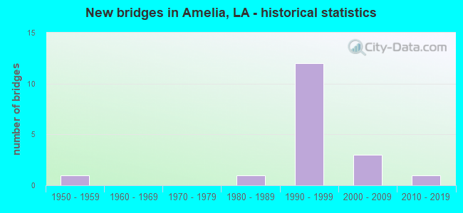
- New bridges - historical statistics
- 11950-1959
- 11980-1989
- 121990-1999
- 32000-2009
- 12010-2019


- Bridge Condition - Deck
- 83.3%Good
- 11.1%Satisfactory
- 5.6%Fair

- Bridge Condition - Superstructure
- 16.7%Very good
- 72.2%Good
- 5.6%Satisfactory
- 5.6%Poor

- Bridge Condition - Substructure
- 22.2%Very good
- 66.7%Good
- 5.6%Fair
- 5.6%Poor

- Bridge Condition - Channel
- 72.7%Very good
- 27.3%Good
Find on map >> Show street view
Structure Number: 35104240537201, Location: 6.24 Mi E of LA 182 (Lat: 29.671211, Lng: -91.110181), Route carried "on" structure: US 90, Year Built: 1998, Status: Open, Structure Length: 10.67m (35.01ft), Average Daily Traffic: 12,650 (year 2016), Truck Traffic: 14%, Average Future Daily Traffic: 42,670 (year 2036), Design Load: HS 20, Features Intersected: CREEK
Minimum Vertical Clearance: 5.18m (16.99ft), Kilometerpoint: 0.000, Lanes on structure: 2, Base Highway Network: Yes (Inventory Route: 424-06-1, Subroute: 10), Owner: State Highway Agency, Approaching Roadway Width: 7.3m (24.0ft), Skew: 10 degrees, Material/Design: Prestressed concrete, Design/Construction: Stringer/Multi-beam, Number Of Spans In Main Unit: 3, Number Of Approach Spans: 7, Length of Maximum Span: 21.3m (69.9ft), Curb-To-Curb Width: 12.2m (40.0ft), Out-to-Out Width: 12.9m (42.3ft)
Condition: Deck: Good, Superstructure: Good, Substructure: Good, Operating Rating: 37.9 metric tons, Method Used To Determine Operating Rating: Load and Resistance Factor Rating (LRFR) rating reported by rating factor(RF) method using HL-93 loadings, Inventory Rating: 29.2 metric tons, Method Used To Determine Inventory Rating: Load and Resistance Factor Rating (LRFR) rating reported by rating factor(RF) method using HL-93 loadings, Structural Evaluation: Better than present minimum criteria, Deck Geometry: Better than present minimum criteria, Waterway Adequacy: Equal to present desirable criteria, Approach Roadway Alignment: Equal to present desirable criteria, Designated Inspection Frequency: Every 24 months, Inspection Date: June 2020, Deck Structure Type: Concrete Cast-file-Place
Find on map >> Show street view
Structure Number: 35104240537202, Location: 1.06 Mi W of La 662 (Lat: 29.671350, Lng: -91.110169), Route carried "on" structure: US 90, Year Built: 1998, Status: Open, Structure Length: 10.67m (35.01ft), Average Daily Traffic: 12,650 (year 2016), Truck Traffic: 14%, Average Future Daily Traffic: 42,670 (year 2036), Design Load: HS 20, Features Intersected: CREEK
Minimum Vertical Clearance: 5.18m (16.99ft), Kilometerpoint: 5.956, Lanes on structure: 2, Base Highway Network: Yes (Inventory Route: 424-06-2, Subroute: 10), Owner: State Highway Agency, Approaching Roadway Width: 7.3m (24.0ft), Skew: 10 degrees, Material/Design: Prestressed concrete, Design/Construction: Stringer/Multi-beam, Number Of Spans In Main Unit: 3, Number Of Approach Spans: 7, Length of Maximum Span: 21.3m (69.9ft), Curb-To-Curb Width: 12.2m (40.0ft), Out-to-Out Width: 12.9m (42.3ft)
Condition: Deck: Good, Superstructure: Good, Substructure: Good, Operating Rating: 36.6 metric tons, Method Used To Determine Operating Rating: Load and Resistance Factor Rating (LRFR) rating reported by rating factor(RF) method using HL-93 loadings, Inventory Rating: 28.2 metric tons, Method Used To Determine Inventory Rating: Load and Resistance Factor Rating (LRFR) rating reported by rating factor(RF) method using HL-93 loadings, Structural Evaluation: Better than present minimum criteria, Deck Geometry: Better than present minimum criteria, Waterway Adequacy: Equal to present desirable criteria, Approach Roadway Alignment: Equal to present desirable criteria, Designated Inspection Frequency: Every 24 months, Inspection Date: June 2020, Deck Structure Type: Concrete Cast-file-Place
Find on map >> Show street view
Structure Number: 61040000061026, Location: 2 MILES EAST OF LA 70 ON (Lat: 29.907019, Lng: -91.191839), Route carried "on" structure: State highway 1016, Year Built: 2010, Status: Open, Structure Length: 1.83m (6.00ft), Average Daily Traffic: 530 (year 2016), Truck Traffic: 10%, Average Future Daily Traffic: 952 (year 2036), Design Load: HS 20, Features Intersected: BAYOU VERRET
Minimum Vertical Clearance: 30+ m (98+ ft), Kilometerpoint: 3.154, Lanes on structure: 2, Owner: State Highway Agency, Approaching Roadway Width: 7.3m (24.0ft), Skew: 30 degrees, Material/Design: Concrete, Design/Construction: Slab, Number Of Spans In Main Unit: 3, Length of Maximum Span: 6.1m (20.0ft), Curb-To-Curb Width: 7.6m (24.9ft), Out-to-Out Width: 8.1m (26.6ft)
Condition: Deck: Good, Superstructure: Very good, Substructure: Very good, Channel: Very good, Operating Rating: 28.5 metric tons, Method Used To Determine Operating Rating: Load and Resistance Factor Rating (LRFR) rating reported by rating factor(RF) method using HL-93 loadings, Inventory Rating: 22.0 metric tons, Method Used To Determine Inventory Rating: Load and Resistance Factor Rating (LRFR) rating reported by rating factor(RF) method using HL-93 loadings, Structural Evaluation: Somewhat better than minimum adequacy, Deck Geometry: Meets minimum limits, Waterway Adequacy: Equal to present desirable criteria, Approach Roadway Alignment: Equal to present desirable criteria, Designated Inspection Frequency: Every 24 months, Inspection Date: December 2020, Deck Structure Type: Concrete Cast-file-Place, Wearing Surface/Protective System: Wearing Surface: Monolithic Concrete
Find on map >> Show street view
Structure Number: 610400050200001, Location: US0090 (Lat: 29.661200, Lng: -91.105000), Route carried "on" structure: State highway 182, Year Built: 1958, Status: Open, Structure Length: 111.40m (365.49ft), Average Daily Traffic: 4,700 (year 2016), Truck Traffic: 7%, Average Future Daily Traffic: 7,820 (year 2036), Design Load: HS 20, Features Intersected: BAYOU BEOUF
Minimum Vertical Clearance: 30+ m (98+ ft), Kilometerpoint: 0.000, Lanes on structure: 2, Lanes under structure: 2, Owner: State Highway Agency, Approaching Roadway Width: 16.2m (53.1ft), Navigation Control: Yes ( Vertical Clearance: 24.4m (80.1ft), Horizontal Clearance: 40.5m (132.9ft)), Material/Design: Steel, Design/Construction: Girder and Floorbeam System, Number Of Spans In Main Unit: 3, Number Of Approach Spans: 63, Length of Maximum Span: 61.0m (200.1ft), Curb-To-Curb Width: 8.7m (28.5ft), Out-to-Out Width: 10.2m (33.5ft)
Condition: Deck: Fair, Superstructure: Poor, Substructure: Poor, Channel: Very good, Operating Rating: 51.2 metric tons, Method Used To Determine Operating Rating: Load and Resistance Factor Rating (LRFR) rating reported by rating factor(RF) method using HL-93 loadings, Inventory Rating: 30.8 metric tons, Method Used To Determine Inventory Rating: Load and Resistance Factor Rating (LRFR) rating reported by rating factor(RF) method using HL-93 loadings, Structural Evaluation: Meets minimum limits, Deck Geometry: Meets minimum limits, Underclear: Meets minimum limits, Waterway Adequacy: Equal to present desirable criteria, Approach Roadway Alignment: Equal to present desirable criteria, Length Of Structure Improvement: 111.40m (365.49ft), Designated Inspection Frequency: Every 24 months, Critical Feature Inspection Frequency: Every 24 months, Other Special Inspection Frequency: Every 12 months, Inspection Date: March 2020, Critical Feature Inspection Date: March 2020, Other Special Inspection Date: March 2021, Bridge Improvement Cost: $9,503,000, Total Project Cost: $14,254,000 ( Estimate for 2016), Deck Structure Type: Concrete Cast-file-Place
Find on map >> Show street view
Structure Number: 610400050200743, Location: 0.2 MI E of LA 662 (Lat: 29.661711, Lng: -91.092600), Route carried "on" structure: ServiceUS 90, Year Built: 2006, Status: Open, Structure Length: 2.41m (7.91ft), Average Daily Traffic: 470 (year 2016), Truck Traffic: 11%, Average Future Daily Traffic: 782 (year 2036), Design Load: HS 20, Features Intersected: DRAIN
Minimum Vertical Clearance: 30+ m (98+ ft), Kilometerpoint: 0.359, Lanes on structure: 2, Owner: State Highway Agency, Approaching Roadway Width: 5.5m (18.0ft), Material/Design: Concrete, Design/Construction: Slab, Number Of Spans In Main Unit: 4, Length of Maximum Span: 5.8m (19.0ft), Curb-To-Curb Width: 13.2m (43.3ft), Out-to-Out Width: 14.0m (45.9ft)
Condition: Deck: Good, Superstructure: Good, Substructure: Good, Channel: Very good, Operating Rating: 77.1 metric tons, Method Used To Determine Operating Rating: Load Factor (LF), Inventory Rating: 46.3 metric tons, Method Used To Determine Inventory Rating: Load Factor (LF), Structural Evaluation: Better than present minimum criteria, Deck Geometry: Superior to present desirable criteria, Waterway Adequacy: Equal to present desirable criteria, Approach Roadway Alignment: Equal to present desirable criteria, Designated Inspection Frequency: Every 24 months, Underwater Inspection Frequency: Every 60 months, Inspection Date: Febuary 2022, Underwater Inspection Date: July 2020, Deck Structure Type: Concrete Cast-file-Place
Find on map >> Show street view
Structure Number: 610400050201471, Location: 0.7 Miles E of US90 Bus (Lat: 29.662469, Lng: -91.080700), Route carried "on" structure: US 182, Year Built: 2006, Status: Open, Structure Length: 2.41m (7.91ft), Average Daily Traffic: 4,700 (year 2016), Truck Traffic: 18%, Average Future Daily Traffic: 7,820 (year 2036), Design Load: HS 20, Features Intersected: BAYOU CAROLINE
Minimum Vertical Clearance: 30+ m (98+ ft), Kilometerpoint: 2.356, Lanes on structure: 2, Base Highway Network: Yes (Inventory Route: 5-02-1, Subroute: 10), Owner: State Highway Agency, Approaching Roadway Width: 14.0m (45.9ft), Material/Design: Concrete, Design/Construction: Slab, Number Of Spans In Main Unit: 4, Length of Maximum Span: 5.8m (19.0ft), Curb-To-Curb Width: 13.2m (43.3ft), Out-to-Out Width: 14.0m (45.9ft)
Condition: Deck: Good, Superstructure: Good, Substructure: Good, Channel: Good, Operating Rating: 77.1 metric tons, Method Used To Determine Operating Rating: Load Factor (LF), Inventory Rating: 46.3 metric tons, Method Used To Determine Inventory Rating: Load Factor (LF), Structural Evaluation: Better than present minimum criteria, Deck Geometry: Equal to present minimum criteria, Waterway Adequacy: Equal to present desirable criteria, Approach Roadway Alignment: Equal to present desirable criteria, Designated Inspection Frequency: Every 24 months, Inspection Date: Febuary 2022, Deck Structure Type: Concrete Cast-file-Place
Find on map >> Show street view
Structure Number: 610400050202071, Location: 2.07MI E OF PH LN ON US90 (Lat: 29.663111, Lng: -91.070700), Route carried "on" structure: US 90, Year Built: 2006, Status: Open, Structure Length: 7.19m (23.59ft), Average Daily Traffic: 4,700 (year 2016), Truck Traffic: 18%, Average Future Daily Traffic: 7,820 (year 2036), Design Load: HS 20, Features Intersected: ALLIGATOR BAYOU
Minimum Vertical Clearance: 13.18m (43.24ft), Kilometerpoint: 3.322, Lanes on structure: 2, Base Highway Network: Yes (Inventory Route: 5-02-1, Subroute: 10), Owner: State Highway Agency, Approaching Roadway Width: 7.0m (23.0ft), Material/Design: Concrete, Design/Construction: Slab, Number Of Spans In Main Unit: 12, Length of Maximum Span: 6.1m (20.0ft), Curb-To-Curb Width: 13.2m (43.3ft), Out-to-Out Width: 14.1m (46.3ft)
Condition: Deck: Good, Superstructure: Good, Substructure: Good, Channel: Good, Operating Rating: 77.1 metric tons, Method Used To Determine Operating Rating: Load Factor (LF), Inventory Rating: 46.3 metric tons, Method Used To Determine Inventory Rating: Load Factor (LF), Structural Evaluation: Better than present minimum criteria, Deck Geometry: Equal to present minimum criteria, Waterway Adequacy: Equal to present desirable criteria, Approach Roadway Alignment: Equal to present desirable criteria, Designated Inspection Frequency: Every 24 months, Inspection Date: Febuary 2022, Deck Structure Type: Concrete Cast-file-Place
Find on map >> Show street view
Structure Number: 610404070604321, Location: 0.20 MI N JCT LA 1011 (Lat: 29.863331, Lng: -90.981611), Route carried "on" structure: State highway 308, Year Built: 1982, Status: Open, Structure Length: 1.74m (5.71ft), Average Daily Traffic: 4,700 (year 2016), Truck Traffic: 11%, Average Future Daily Traffic: 8,160 (year 2036), Design Load: HS 20, Features Intersected: BAYOU VALANCE
Minimum Vertical Clearance: 30+ m (98+ ft), Kilometerpoint: 6.835, Lanes on structure: 2, Owner: State Highway Agency, Approaching Roadway Width: 10.4m (34.1ft), Material/Design: Concrete, Design/Construction: Slab, Number Of Spans In Main Unit: 3, Length of Maximum Span: 5.8m (19.0ft), Curb-To-Curb Width: 8.5m (27.9ft), Out-to-Out Width: 9.4m (30.8ft)
Condition: Deck: Good, Superstructure: Good, Substructure: Fair, Channel: Very good, Operating Rating: 61.7 metric tons, Method Used To Determine Operating Rating: Load Factor (LF), Inventory Rating: 37.2 metric tons, Method Used To Determine Inventory Rating: Load Factor (LF), Structural Evaluation: Somewhat better than minimum adequacy, Deck Geometry: Meets minimum limits, Waterway Adequacy: Equal to present desirable criteria, Approach Roadway Alignment: Equal to present desirable criteria, Designated Inspection Frequency: Every 24 months, Inspection Date: December 2021, Deck Structure Type: Concrete Cast-file-Place, Wearing Surface/Protective System: Wearing Surface: Bituminous
Find on map >> Show street view
Structure Number: 610404240600001, Location: ASSUMPTION PH LN US 90 (Lat: 29.671239, Lng: -91.108700), Route carried "on" structure: US 90, Year Built: 1998, Status: Open, Structure Length: 165.02m (541.40ft), Average Daily Traffic: 25,300 (year 2016), Truck Traffic: 14%, Average Future Daily Traffic: 42,670 (year 2036), Design Load: HS 20, Features Intersected: BAYOU BOEUF
Minimum Vertical Clearance: 30+ m (98+ ft), Kilometerpoint: 0.142, Lanes on structure: 4, Lanes under structure: 1, Base Highway Network: Yes (Inventory Route: 424-06-2, Subroute: 10), Owner: State Highway Agency, Approaching Roadway Width: 12.2m (40.0ft), Skew: 10 degrees, Navigation Control: Yes ( Vertical Clearance: 22.3m (73.2ft), Horizontal Clearance: 56.4m (185.0ft)), Material/Design: Prestressed concrete, Design/Construction: Stringer/Multi-beam, Number Of Spans In Main Unit: 4, Number Of Approach Spans: 59, Length of Maximum Span: 178.3m (585.0ft), Curb-To-Curb Width: 24.4m (80.1ft), Out-to-Out Width: 25.8m (84.6ft)
Condition: Deck: Good, Superstructure: Satisfactory, Substructure: Good, Channel: Very good, Operating Rating: 28.8 metric tons, Method Used To Determine Operating Rating: Load and Resistance Factor Rating (LRFR) rating reported by rating factor(RF) method using HL-93 loadings, Inventory Rating: 17.8 metric tons, Method Used To Determine Inventory Rating: Load and Resistance Factor Rating (LRFR) rating reported by rating factor(RF) method using HL-93 loadings, Structural Evaluation: Meets minimum limits, Deck Geometry: Superior to present desirable criteria, Waterway Adequacy: Equal to present desirable criteria, Approach Roadway Alignment: Equal to present desirable criteria, Designated Inspection Frequency: Every 24 months, Underwater Inspection Frequency: Every 60 months, Inspection Date: March 2020, Underwater Inspection Date: March 2018, Deck Structure Type: Concrete Cast-file-Place
Find on map >> Show street view
Structure Number: 610404240600015, Location: 1.0 M W of US 90&LA 662 (Lat: 29.670700, Lng: -91.109000), Route carried "on" structure: Ramp US 90, Year Built: 1998, Status: Open, Structure Length: 8.11m (26.61ft), Average Daily Traffic: 2,530 (year 2016), Truck Traffic: 14%, Average Future Daily Traffic: 4,267 (year 2036), Design Load: HS 20, Features Intersected: GROUND
Minimum Vertical Clearance: 30+ m (98+ ft), Kilometerpoint: 0.309, Lanes on structure: 1, Owner: State Highway Agency, Approaching Roadway Width: 12.2m (40.0ft), Material/Design: Prestressed concrete continuous, Design/Construction: Stringer/Multi-beam, Number Of Spans In Main Unit: 2, Number Of Approach Spans: 7, Length of Maximum Span: 19.8m (65.0ft), Curb-To-Curb Width: 9.1m (29.9ft), Out-to-Out Width: 10.1m (33.1ft)
Condition: Deck: Good, Superstructure: Good, Substructure: Good, Channel: Very good, Operating Rating: 46.3 metric tons, Method Used To Determine Operating Rating: Load and Resistance Factor Rating (LRFR) rating reported by rating factor(RF) method using HL-93 loadings, Inventory Rating: 29.2 metric tons, Method Used To Determine Inventory Rating: Load and Resistance Factor Rating (LRFR) rating reported by rating factor(RF) method using HL-93 loadings, Structural Evaluation: Better than present minimum criteria, Deck Geometry: Superior to present desirable criteria, Approach Roadway Alignment: Equal to present minimum criteria, Designated Inspection Frequency: Every 24 months, Inspection Date: August 2020, Deck Structure Type: Concrete Cast-file-Place
Find on map >> Show street view
Structure Number: 610404240600018, Location: 1.0 M W of US 90&LA 662 (Lat: 29.671281, Lng: -91.105631), Route carried "on" structure: Ramp US 90, Year Built: 1998, Status: Open, Structure Length: 64.71m (212.30ft), Average Daily Traffic: 2,530 (year 2016), Truck Traffic: 14%, Average Future Daily Traffic: 4,267 (year 2036), Design Load: HS 20, Features Intersected: WEST BOUND RAMP (OFF)
Minimum Vertical Clearance: 30+ m (98+ ft), Kilometerpoint: 0.185, Lanes on structure: 1, Lanes under structure: 8, Owner: State Highway Agency, Approaching Roadway Width: 7.6m (24.9ft), Material/Design: Prestressed concrete continuous, Design/Construction: Stringer/Multi-beam, Number Of Spans In Main Unit: 26, Number Of Approach Spans: 5, Length of Maximum Span: 28.7m (94.2ft), Curb-To-Curb Width: 7.6m (24.9ft), Out-to-Out Width: 8.1m (26.6ft)
Condition: Deck: Good, Superstructure: Good, Substructure: Very good, Operating Rating: 61.7 metric tons, Method Used To Determine Operating Rating: Load Factor (LF), Inventory Rating: 37.2 metric tons, Method Used To Determine Inventory Rating: Load Factor (LF), Structural Evaluation: Better than present minimum criteria, Deck Geometry: Better than present minimum criteria, Underclear: High priority of corrective action, Approach Roadway Alignment: Equal to present desirable criteria, Designated Inspection Frequency: Every 24 months, Inspection Date: March 2020, Deck Structure Type: Concrete Cast-file-Place
Find on map >> Show street view
Structure Number: 610404240600907, Location: 0.2 M E of US 90&LA 662 (Lat: 29.670189, Lng: -91.094039), Route carried "on" structure: Ramp State highway 90, Year Built: 1996, Status: Open, Structure Length: 65.62m (215.29ft), Average Daily Traffic: 2,530 (year 2016), Truck Traffic: 14%, Average Future Daily Traffic: 4,267 (year 2036), Design Load: HS 20, Features Intersected: EAST BOUND OFF RAMP
Minimum Vertical Clearance: 30+ m (98+ ft), Kilometerpoint: 0.264, Lanes on structure: 1, Lanes under structure: 2, Owner: State Highway Agency, Approaching Roadway Width: 6.1m (20.0ft), Material/Design: Prestressed concrete continuous, Design/Construction: Stringer/Multi-beam, Number Of Spans In Main Unit: 27, Number Of Approach Spans: 5, Length of Maximum Span: 36.6m (120.1ft), Curb-To-Curb Width: 7.6m (24.9ft), Out-to-Out Width: 8.5m (27.9ft)
Condition: Deck: Good, Superstructure: Good, Substructure: Good, Operating Rating: 72.6 metric tons, Method Used To Determine Operating Rating: Load Factor (LF), Inventory Rating: 40.8 metric tons, Method Used To Determine Inventory Rating: Load Factor (LF), Structural Evaluation: Better than present minimum criteria, Deck Geometry: Better than present minimum criteria, Approach Roadway Alignment: Equal to present desirable criteria, Designated Inspection Frequency: Every 24 months, Inspection Date: March 2020, Deck Structure Type: Concrete Cast-file-Place
Find on map >> Show street view
Structure Number: 610404240601001, Location: JCT of US 90 & LA 662 (Lat: 29.670281, Lng: -91.093581), Route carried "on" structure: US 90, Year Built: 1998, Status: Open, Structure Length: 368.17m (1207.91ft), Average Daily Traffic: 12,650 (year 2016), Truck Traffic: 17%, Average Future Daily Traffic: 42,670 (year 2036), Design Load: HS 20, Features Intersected: BAYOU BEOUF BR EXTEN
Minimum Vertical Clearance: 5.13m (16.83ft), Kilometerpoint: 1.609, Lanes on structure: 2, Base Highway Network: Yes (Inventory Route: 424-06-1, Subroute: 10), Owner: State Highway Agency, Approaching Roadway Width: 12.2m (40.0ft), Skew: 10 degrees, Material/Design: Prestressed concrete, Design/Construction: Stringer/Multi-beam, Number Of Spans In Main Unit: 170, Length of Maximum Span: 21.3m (69.9ft), Curb-To-Curb Width: 12.2m (40.0ft), Out-to-Out Width: 12.9m (42.3ft)
Condition: Deck: Satisfactory, Superstructure: Good, Substructure: Good, Channel: Very good, Operating Rating: 36.9 metric tons, Method Used To Determine Operating Rating: Load and Resistance Factor Rating (LRFR) rating reported by rating factor(RF) method using HL-93 loadings, Inventory Rating: 27.5 metric tons, Method Used To Determine Inventory Rating: Load and Resistance Factor Rating (LRFR) rating reported by rating factor(RF) method using HL-93 loadings, Structural Evaluation: Equal to present minimum criteria, Deck Geometry: Better than present minimum criteria, Approach Roadway Alignment: Equal to present desirable criteria, Designated Inspection Frequency: Every 24 months, Inspection Date: September 2020, Deck Structure Type: Concrete Cast-file-Place
Find on map >> Show street view
Structure Number: 610404240601002, Location: JCT of US 90 & LA 662 (Lat: 29.668089, Lng: -91.053139), Route carried "on" structure: US 90, Year Built: 1998, Status: Open, Structure Length: 368.02m (1207.41ft), Average Daily Traffic: 12,650 (year 2016), Truck Traffic: 14%, Average Future Daily Traffic: 42,670 (year 2036), Design Load: HS 20, Features Intersected: BAYOU BOEUF BR EXTENSION
Minimum Vertical Clearance: 5.11m (16.77ft), Kilometerpoint: 4.490, Lanes on structure: 2, Base Highway Network: Yes (Inventory Route: 424-06-2, Subroute: 10), Owner: State Highway Agency, Approaching Roadway Width: 12.2m (40.0ft), Skew: 10 degrees, Material/Design: Prestressed concrete, Design/Construction: Stringer/Multi-beam, Number Of Spans In Main Unit: 170, Length of Maximum Span: 21.3m (69.9ft), Curb-To-Curb Width: 12.2m (40.0ft), Out-to-Out Width: 12.9m (42.3ft)
Condition: Deck: Satisfactory, Superstructure: Good, Substructure: Good, Channel: Very good, Operating Rating: 37.3 metric tons, Method Used To Determine Operating Rating: Load and Resistance Factor Rating (LRFR) rating reported by rating factor(RF) method using HL-93 loadings, Inventory Rating: 28.8 metric tons, Method Used To Determine Inventory Rating: Load and Resistance Factor Rating (LRFR) rating reported by rating factor(RF) method using HL-93 loadings, Structural Evaluation: Better than present minimum criteria, Deck Geometry: Better than present minimum criteria, Approach Roadway Alignment: Equal to present desirable criteria, Length Of Structure Improvement: 368.02m (1207.41ft), Designated Inspection Frequency: Every 24 months, Inspection Date: September 2020, Bridge Improvement Cost: $31,392,000, Total Project Cost: $47,088,000 ( Estimate for 2016), Deck Structure Type: Concrete Cast-file-Place
Find on map >> Show street view
Structure Number: 610404240601006, Location: 0.1 M E of US 90&LA 662 (Lat: 29.670739, Lng: -91.090669), Route carried "on" structure: Ramp US 90, Year Built: 1998, Status: Open, Structure Length: 5.76m (18.90ft), Average Daily Traffic: 2,530 (year 2016), Truck Traffic: 14%, Average Future Daily Traffic: 4,267 (year 2036), Design Load: HS 20, Features Intersected: WESTBOUND ON RAMP
Minimum Vertical Clearance: 30+ m (98+ ft), Kilometerpoint: 0.340, Lanes on structure: 1, Owner: State Highway Agency, Approaching Roadway Width: 9.8m (32.2ft), Material/Design: Prestressed concrete continuous, Design/Construction: Stringer/Multi-beam, Number Of Spans In Main Unit: 2, Number Of Approach Spans: 3, Length of Maximum Span: 19.8m (65.0ft), Curb-To-Curb Width: 9.1m (29.9ft), Out-to-Out Width: 10.1m (33.1ft)
Condition: Deck: Good, Superstructure: Good, Substructure: Good, Operating Rating: 45.7 metric tons, Method Used To Determine Operating Rating: Load and Resistance Factor Rating (LRFR) rating reported by rating factor(RF) method using HL-93 loadings, Inventory Rating: 25.3 metric tons, Method Used To Determine Inventory Rating: Load and Resistance Factor Rating (LRFR) rating reported by rating factor(RF) method using HL-93 loadings, Structural Evaluation: Equal to present minimum criteria, Deck Geometry: Superior to present desirable criteria, Approach Roadway Alignment: Equal to present minimum criteria, Designated Inspection Frequency: Every 24 months, Inspection Date: August 2020, Deck Structure Type: Concrete Cast-file-Place
Find on map >> Show street view
Structure Number: 610404240601035, Location: 0.6 M SE of US 90&LA 662 (Lat: 29.669361, Lng: -91.088439), Route carried "on" structure: Ramp US 90, Year Built: 1999, Status: Open, Structure Length: 16.12m (52.89ft), Average Daily Traffic: 2,530 (year 2016), Truck Traffic: 14%, Average Future Daily Traffic: 4,267 (year 2036), Design Load: HS 20, Features Intersected: ONGOING RAMP B.E.
Minimum Vertical Clearance: 30+ m (98+ ft), Kilometerpoint: 0.412, Lanes on structure: 1, Owner: State Highway Agency, Approaching Roadway Width: 7.6m (24.9ft), Material/Design: Prestressed concrete continuous, Design/Construction: Stringer/Multi-beam, Number Of Spans In Main Unit: 5, Number Of Approach Spans: 4, Length of Maximum Span: 23.5m (77.1ft), Curb-To-Curb Width: 7.6m (24.9ft), Out-to-Out Width: 8.5m (27.9ft)
Condition: Deck: Good, Superstructure: Very good, Substructure: Very good, Operating Rating: 37.6 metric tons, Method Used To Determine Operating Rating: Load and Resistance Factor Rating (LRFR) rating reported by rating factor(RF) method using HL-93 loadings, Inventory Rating: 28.8 metric tons, Method Used To Determine Inventory Rating: Load and Resistance Factor Rating (LRFR) rating reported by rating factor(RF) method using HL-93 loadings, Structural Evaluation: Better than present minimum criteria, Deck Geometry: Better than present minimum criteria, Approach Roadway Alignment: Equal to present desirable criteria, Designated Inspection Frequency: Every 24 months, Inspection Date: August 2020, Deck Structure Type: Concrete Cast-file-Place
Find on map >> Show street view
Structure Number: 610404240601038, Location: 0.6 M SE of US 90&LA 662 (Lat: 29.670011, Lng: -91.086369), Route carried "on" structure: Ramp US 90, Year Built: 1999, Status: Open, Structure Length: 14.81m (48.59ft), Average Daily Traffic: 2,530 (year 2016), Truck Traffic: 14%, Average Future Daily Traffic: 4,267 (year 2036), Design Load: HS 20, Features Intersected: OFFGOING RAMP A.E.
Minimum Vertical Clearance: 30+ m (98+ ft), Kilometerpoint: 0.269, Lanes on structure: 1, Owner: State Highway Agency, Approaching Roadway Width: 12.2m (40.0ft), Material/Design: Prestressed concrete continuous, Design/Construction: Stringer/Multi-beam, Number Of Spans In Main Unit: 5, Number Of Approach Spans: 4, Length of Maximum Span: 22.9m (75.1ft), Curb-To-Curb Width: 8.8m (28.9ft), Out-to-Out Width: 9.8m (32.2ft)
Condition: Deck: Good, Superstructure: Very good, Substructure: Very good, Operating Rating: 44.7 metric tons, Method Used To Determine Operating Rating: Load and Resistance Factor Rating (LRFR) rating reported by rating factor(RF) method using HL-93 loadings, Inventory Rating: 29.8 metric tons, Method Used To Determine Inventory Rating: Load and Resistance Factor Rating (LRFR) rating reported by rating factor(RF) method using HL-93 loadings, Structural Evaluation: Better than present minimum criteria, Deck Geometry: Superior to present desirable criteria, Approach Roadway Alignment: Equal to present minimum criteria, Designated Inspection Frequency: Every 24 months, Inspection Date: August 2020, Deck Structure Type: Concrete Cast-file-Place
Find on map >> Show street view
Structure Number: 610408042302041, Location: 2.04 MI N OF END OF LA662 (Lat: 29.669350, Lng: -91.092669), Route carried "on" structure: State highway 662, Year Built: 1998, Status: Open, Structure Length: 2.74m (8.99ft), Average Daily Traffic: 4,100 (year 2016), Truck Traffic: 11%, Average Future Daily Traffic: 6,970 (year 2036), Design Load: HS 20, Features Intersected: PUMPING STATION BRIDGE
Minimum Vertical Clearance: 30+ m (98+ ft), Kilometerpoint: 3.296, Lanes on structure: 4, Owner: State Highway Agency, Approaching Roadway Width: 28.0m (91.9ft), Skew: 30 degrees, Material/Design: Concrete, Design/Construction: Slab, Number Of Spans In Main Unit: 3, Length of Maximum Span: 9.1m (29.9ft), Curb-To-Curb Width: 27.4m (89.9ft), Out-to-Out Width: 28.3m (92.8ft)
Condition: Deck: Good, Superstructure: Good, Substructure: Good, Channel: Good, Operating Rating: 80.7 metric tons, Method Used To Determine Operating Rating: Load Factor (LF), Inventory Rating: 48.1 metric tons, Method Used To Determine Inventory Rating: Load Factor (LF), Structural Evaluation: Better than present minimum criteria, Deck Geometry: Superior to present desirable criteria, Waterway Adequacy: Equal to present desirable criteria, Approach Roadway Alignment: Equal to present desirable criteria, Designated Inspection Frequency: Every 24 months, Underwater Inspection Frequency: Every 60 months, Inspection Date: August 2020, Underwater Inspection Date: March 2019, Deck Structure Type: Concrete Cast-file-Place
Find on map >> Show street view
Structure Number: 610400050200001, Location: .8 miles S of US 90 (Lat: 29.661800, Lng: -91.096350), Route carried "under" structure: State highway 662, Structure Length: 0. m, Average Daily Traffic: 2,050 (year 2014), Features Intersected: LA 662 SB under LA 182
Minimum Vertical Clearance: 13.53m (44.39ft), Kilometerpoint: 15.150, Lanes on structure: 2, Lanes under structure: 2, Length of Maximum Span: 0.0m
Find on map >> Show street view
Structure Number: 610400050200001, Location: .8 miles S of US 90 (Lat: 29.661719, Lng: -91.096339), Route carried "under" structure: State highway 662, Structure Length: 0. m, Average Daily Traffic: 2,050 (year 2014), Features Intersected: LA 662 NB under LA 182
Minimum Vertical Clearance: 13.44m (44.09ft), Kilometerpoint: 2.065, Lanes on structure: 2, Lanes under structure: 2, Length of Maximum Span: 0.0m
Find on map >> Show street view
Structure Number: 610404240600018, Location: 6.50 MI E Of LA 70 (Lat: 29.671189, Lng: -91.109739), Route carried "under" structure: US 90, Structure Length: 0. m, Average Daily Traffic: 12,650 (year 2016), Features Intersected: US 90 EB under US 90 WB
Minimum Vertical Clearance: 5.33m (17.49ft), Kilometerpoint: 0.042, Lanes on structure: 1, Lanes under structure: 2, Length of Maximum Span: 0.0m
Find on map >> Show street view
Structure Number: 610404240600018, Location: 1.40 MI W of LA 662 (Lat: 29.671311, Lng: -91.109539), Route carried "under" structure: US 90, Structure Length: 0. m, Average Daily Traffic: 12,650 (year 2016), Features Intersected: US 90 WB under US 90 WB
Minimum Vertical Clearance: 5.24m (17.19ft), Kilometerpoint: 6.040, Lanes on structure: 1, Lanes under structure: 2, Length of Maximum Span: 0.0m
Find on map >> Show street view
Structure Number: 610404240600907, Location: 3.40 MI S of LA 663 (Lat: 29.669839, Lng: -91.092769), Route carried "under" structure: State highway 662, Structure Length: 0. m, Average Daily Traffic: 4,100 (year 2016), Features Intersected: LA 662 SB under Us 90 EB
Minimum Vertical Clearance: 6.31m (20.70ft), Kilometerpoint: 13.874, Lanes on structure: 1, Lanes under structure: 2, Length of Maximum Span: 0.0m
Find on map >> Show street view
Structure Number: 610404240600907, Location: 0.53 MI N of LA 182 (Lat: 29.669681, Lng: -91.092581), Route carried "under" structure: State highway 662, Structure Length: 0. m, Average Daily Traffic: 4,100 (year 2016), Features Intersected: LA 662 NB under US 90 EB
Minimum Vertical Clearance: 6.28m (20.60ft), Kilometerpoint: 3.331, Lanes on structure: 1, Lanes under structure: 2, Length of Maximum Span: 0.0m
Find on map >> Show street view
Structure Number: 610404240600907, Location: 2.75 Mi W of LA 662 (Lat: 29.670100, Lng: -91.089700), Route carried "under" structure: US 90, Structure Length: 0. m, Average Daily Traffic: 12,650 (year 2016), Features Intersected: US 90 WB under US 90 EB
Minimum Vertical Clearance: 5.15m (16.90ft), Kilometerpoint: 4.113, Lanes on structure: 1, Lanes under structure: 2, Length of Maximum Span: 0.0m
Find on map >> Show street view
Structure Number: 610404240600907, Location: 0.16 MI E of LA 662 (Lat: 29.669900, Lng: -91.089969), Route carried "under" structure: US 90, Structure Length: 0. m, Average Daily Traffic: 12,650 (year 2016), Features Intersected: US 90 EB under US 90 EB
Minimum Vertical Clearance: 5.27m (17.29ft), Kilometerpoint: 1.960, Lanes on structure: 1, Lanes under structure: 2, Length of Maximum Span: 0.0m
Find on map >> Show street view
Structure Number: 610404240601001, Location: 3.27 MI S of LA 663 (Lat: 29.670231, Lng: -91.092789), Route carried "under" structure: State highway 662, Structure Length: 0. m, Average Daily Traffic: 2,050 (year 2016), Features Intersected: LA 662 SB under US 90 EB
Minimum Vertical Clearance: 5.67m (18.60ft), Kilometerpoint: 13.831, Lanes on structure: 2, Lanes under structure: 2, Length of Maximum Span: 0.0m
Find on map >> Show street view
Structure Number: 610404240601001, Location: .056 MI N of LA 182 (Lat: 29.670089, Lng: -91.092600), Route carried "under" structure: State highway 662, Structure Length: 0. m, Average Daily Traffic: 2,050 (year 2016), Features Intersected: LA 662 NB under US 90 EB
Minimum Vertical Clearance: 5.18m (16.99ft), Kilometerpoint: 3.378, Lanes on structure: 2, Lanes under structure: 2, Length of Maximum Span: 0.0m
Find on map >> Show street view
Structure Number: 610404240601002, Location: 0.57 MI N of LA 182 (Lat: 29.670219, Lng: -91.092611), Route carried "under" structure: State highway 662, Structure Length: 0. m, Average Daily Traffic: 2,050 (year 2016), Features Intersected: LA 662 NB under US 90 WB
Minimum Vertical Clearance: 5.18m (16.99ft), Kilometerpoint: 3.392, Lanes on structure: 2, Lanes under structure: 2, Length of Maximum Span: 0.0m
Find on map >> Show street view
Structure Number: 610404240601002, Location: 3.26 MI S of LA 663 (Lat: 29.670381, Lng: -91.092811), Route carried "under" structure: State highway 662, Structure Length: 0. m, Average Daily Traffic: 2,050 (year 2016), Features Intersected: LA 662 SB under US 90 WB
Minimum Vertical Clearance: 5.67m (18.60ft), Kilometerpoint: 13.813, Lanes on structure: 2, Lanes under structure: 2, Length of Maximum Span: 0.0m