Bridge Statistics for Amity, New York (NY)
Condition, Traffic, Stress, Structural Evaluation, Project Costs
- National Bridge Inventory (NBI) Statistics
- 17Number of bridges
- 125ft / 38.1mTotal length
- $25,135,000Total costs
- 17,130Total average daily traffic
- 1,492Total average daily truck traffic
- National Bridge Inventory (NBI) Registered Bridges for Amity
- No street view available for this location
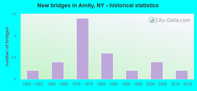
- New bridges - historical statistics
- 11950-1959
- 21960-1969
- 71970-1979
- 31980-1989
- 11990-1999
- 22000-2009
- 12010-2019

- Reconstructed bridges - Historical Statistics
- 21980-1989
- 21990-1999
- 12000-2009
- 12010-2019


- Bridge Condition - Deck
- 16.7%Excellent
- 16.7%Very good
- 25.0%Good
- 41.7%Satisfactory

- Bridge Condition - Superstructure
- 7.7%Excellent
- 7.7%Very good
- 38.5%Good
- 15.4%Satisfactory
- 30.8%Fair

- Bridge Condition - Substructure
- 15.4%Very good
- 23.1%Good
- 23.1%Satisfactory
- 30.8%Fair
- 7.7%Poor

- Bridge Condition - Channel
- 6.7%Very good
- 26.7%Good
- 26.7%Satisfactory
- 33.3%Fair
- 6.7%Serious

- Bridge Condition - Culverts
- 33.3%Very good
- 33.3%Good
- 33.3%Fair
Find on map >> Show street view
Structure Number: 101498, Location: .8 MI NW JCT SR19 & SR244 (Lat: 42.230911, Lng: -78.049383), Route carried "on" structure: State highway 19, Year Built: 1957, Status: Open, Structure Length: 0.91m (2.99ft), Average Daily Traffic: 3,649 (year 2018), Truck Traffic: 10%, Average Future Daily Traffic: 3,683 (year 2040), Design Load: H 20, Features Intersected: TUCKER CORNERS CK
Minimum Vertical Clearance: 30+ m (98+ ft), Kilometerpoint: 32.470, Lanes on structure: 2, Base Highway Network: Yes, Owner: State Highway Agency, Approaching Roadway Width: 12.2m (40.0ft), Skew: 3 degrees, Material/Design: Concrete, Design/Construction: Culvert, Number Of Spans In Main Unit: 1, Length of Maximum Span: 8.2m (26.9ft)
Condition: Channel: Fair, Culverts: Fair, Operating Rating: 43.7 metric tons, Method Used To Determine Operating Rating: Load and Resistance Factor Rating (LRFR) rating reported by rating factor(RF) method using HL-93 loadings, Inventory Rating: 33.7 metric tons, Method Used To Determine Inventory Rating: Load and Resistance Factor Rating (LRFR) rating reported by rating factor(RF) method using HL-93 loadings, Structural Evaluation: Somewhat better than minimum adequacy, Waterway Adequacy: Somewhat better than minimum adequacy, Approach Roadway Alignment: Equal to present desirable criteria, Length Of Structure Improvement: 0.91m (2.99ft), Designated Inspection Frequency: Every 24 months, Inspection Date: March 2021, Bridge Improvement Cost: $242,000, Roadway Improvement Cost: $142,000, Total Project Cost: $384,000 ( Estimate for 2021)
Find on map >> Show street view
Structure Number: 101499, Location: .6 MI S JCT I86 & SR 19 (Lat: 42.251906, Lng: -78.057869), Route carried "on" structure: State highway 19, Year Built: 2008, Status: Open, Structure Length: 5.97m (19.59ft), Average Daily Traffic: 3,649 (year 2018), Truck Traffic: 10%, Average Future Daily Traffic: 3,683 (year 2040), Design Load: HL 93, Features Intersected: WNY & Pa RR, Van Campen
Minimum Vertical Clearance: 30+ m (98+ ft), Kilometerpoint: 34.899, Lanes on structure: 2, Base Highway Network: Yes, Owner: State Highway Agency, Approaching Roadway Width: 11.9m (39.0ft), Skew: 3 degrees, Material/Design: Steel, Design/Construction: Stringer/Multi-beam, Number Of Spans In Main Unit: 1, Length of Maximum Span: 58.0m (190.3ft), Curb-To-Curb Width: 12.0m (39.4ft), Out-to-Out Width: 12.9m (42.3ft)
Condition: Deck: Satisfactory, Superstructure: Good, Substructure: Satisfactory, Channel: Satisfactory, Operating Rating: 90.0 metric tons, Method Used To Determine Operating Rating: Load Factor (LF), Inventory Rating: 54.0 metric tons, Method Used To Determine Inventory Rating: Load Factor (LF), Structural Evaluation: Equal to present minimum criteria, Deck Geometry: Somewhat better than minimum adequacy, Underclear: Better than present minimum criteria, Waterway Adequacy: Equal to present minimum criteria, Approach Roadway Alignment: Equal to present desirable criteria, Length Of Structure Improvement: 5.97m (19.59ft), Designated Inspection Frequency: Every 24 months, Inspection Date: August 2020, Bridge Improvement Cost: $2,758,000, Roadway Improvement Cost: $1,615,000, Total Project Cost: $4,374,000 ( Estimate for 2021), Deck Structure Type: Concrete Cast-file-Place, Wearing Surface/Protective System: Wearing Surface: Monolithic Concrete, Deck Protection: Epoxy Coated Reinforcing
Find on map >> Show street view
Structure Number: 104287, Location: 1.5 MI NE JCT RTS 19 +244 (Lat: 42.240253, Lng: -78.016531), Route carried "on" structure: State highway 244, Year Built: 1997, Status: Open, Structure Length: 1.43m (4.69ft), Average Daily Traffic: 901 (year 2020), Truck Traffic: 10%, Average Future Daily Traffic: 939 (year 2040), Design Load: HS 25 or greater, Features Intersected: FEATHERS CREEK
Minimum Vertical Clearance: 30+ m (98+ ft), Kilometerpoint: 2.414, Lanes on structure: 2, Base Highway Network: Yes, Owner: State Highway Agency, Approaching Roadway Width: 9.1m (29.9ft), Skew: 2 degrees, Material/Design: Concrete, Design/Construction: Culvert, Number Of Spans In Main Unit: 1, Length of Maximum Span: 13.4m (44.0ft)
Condition: Channel: Good, Culverts: Very good, Operating Rating: 77.1 metric tons, Method Used To Determine Operating Rating: Load Factor (LF), Inventory Rating: 51.7 metric tons, Method Used To Determine Inventory Rating: Load Factor (LF), Structural Evaluation: Equal to present desirable criteria, Waterway Adequacy: Somewhat better than minimum adequacy, Approach Roadway Alignment: Equal to present desirable criteria, Length Of Structure Improvement: 1.43m (4.69ft), Designated Inspection Frequency: Every 24 months, Inspection Date: November 2021, Bridge Improvement Cost: $284,000, Roadway Improvement Cost: $167,000, Total Project Cost: $451,000 ( Estimate for 2021)
Find on map >> Show street view
Structure Number: 104288, Location: 3.1 MI NE JCT SH19 &SH244 (Lat: 42.245536, Lng: -77.987936), Route carried "on" structure: State highway 244, Year Built: 2010, Status: Open, Structure Length: 1.31m (4.30ft), Average Daily Traffic: 901 (year 2020), Truck Traffic: 10%, Average Future Daily Traffic: 939 (year 2040), Design Load: HS 25 or greater, Features Intersected: N BR PHILLIPS CRK
Minimum Vertical Clearance: 30+ m (98+ ft), Kilometerpoint: 5.004, Lanes on structure: 2, Base Highway Network: Yes, Owner: State Highway Agency, Approaching Roadway Width: 9.1m (29.9ft), Skew: 1 degrees, Material/Design: Concrete, Design/Construction: Frame, Number Of Spans In Main Unit: 1, Length of Maximum Span: 12.5m (41.0ft), Curb-To-Curb Width: 9.1m (29.9ft), Out-to-Out Width: 10.1m (33.1ft)
Condition: Superstructure: Good, Substructure: Good, Channel: Good, Inventory Rating: 63.5 metric tons, Method Used To Determine Inventory Rating: Load Factor (LF), Structural Evaluation: Better than present minimum criteria, Deck Geometry: Equal to present minimum criteria, Waterway Adequacy: Equal to present desirable criteria, Approach Roadway Alignment: Equal to present desirable criteria, Length Of Structure Improvement: 1.31m (4.30ft), Designated Inspection Frequency: Every 24 months, Inspection Date: November 2020, Bridge Improvement Cost: $589,000, Roadway Improvement Cost: $345,000, Total Project Cost: $934,000 ( Estimate for 2021)
Find on map >> Show street view
Structure Number: 106166, Location: JCT RTS 17 + 19 (Lat: 42.260089, Lng: -78.063058), Route carried "on" structure: State highway 19, Year Built: 1971, Year Reconstructed: 2003, Status: Open, Structure Length: 7.47m (24.51ft), Average Daily Traffic: 3,649 (year 2020), Truck Traffic: 14%, Average Future Daily Traffic: 3,683 (year 2040), Design Load: HS 20+Mod, Features Intersected: 86I 17 61032148 (WB), RT
Minimum Vertical Clearance: 30+ m (98+ ft), Kilometerpoint: 35.913, Lanes on structure: 2, Lanes under structure: 4, Base Highway Network: Yes, Owner: State Highway Agency, Approaching Roadway Width: 18.3m (60.0ft), Skew: 3 degrees, Material/Design: Steel, Design/Construction: Stringer/Multi-beam, Number Of Spans In Main Unit: 2, Length of Maximum Span: 36.5m (119.8ft), Curb-To-Curb Width: 19.2m (63.0ft), Out-to-Out Width: 20.1m (65.9ft)
Condition: Deck: Satisfactory, Superstructure: Fair, Substructure: Fair, Operating Rating: 98.0 metric tons, Method Used To Determine Operating Rating: Load Factor (LF), Inventory Rating: 58.1 metric tons, Method Used To Determine Inventory Rating: Load Factor (LF), Structural Evaluation: Somewhat better than minimum adequacy, Deck Geometry: Superior to present desirable criteria, Underclear: Better than present minimum criteria, Approach Roadway Alignment: Equal to present desirable criteria, Length Of Structure Improvement: 7.46m (24.48ft), Designated Inspection Frequency: Every 24 months, Inspection Date: September 2021, Bridge Improvement Cost: $5,001,000, Roadway Improvement Cost: $2,928,000, Total Project Cost: $7,929,000 ( Estimate for 2021), Deck Structure Type: Concrete Cast-file-Place, Wearing Surface/Protective System: Wearing Surface: Integral Concrete
Find on map >> Show street view
Structure Number: 221396, Location: 3.0 MI NE BELMONT (Lat: 42.246522, Lng: -77.960969), Route carried "on" structure: Alternate Other road , Year Built: 1979, Year Reconstructed: 2012, Status: Open, Structure Length: 2.13m (6.99ft), Average Daily Traffic: 50 (year 2018), Average Future Daily Traffic: 70 (year 2038), Design Load: H 20, Features Intersected: PHILLIPS CREEK, Facility Carried by Structure: IRISH SETTLEMENT
Minimum Vertical Clearance: 30+ m (98+ ft), Kilometerpoint: 0.418, Lanes on structure: 2, Owner: Town or Township Highway Agency, Approaching Roadway Width: 6.1m (20.0ft), Material/Design: Steel, Design/Construction: Stringer/Multi-beam, Number Of Spans In Main Unit: 1, Length of Maximum Span: 20.7m (67.9ft), Curb-To-Curb Width: 7.2m (23.6ft), Out-to-Out Width: 7.3m (24.0ft)
Condition: Deck: Excellent, Superstructure: Fair, Substructure: Satisfactory, Channel: Good, Inventory Rating: 61.7 metric tons, Method Used To Determine Inventory Rating: Load Factor (LF), Structural Evaluation: Somewhat better than minimum adequacy, Deck Geometry: Somewhat better than minimum adequacy, Waterway Adequacy: Better than present minimum criteria, Approach Roadway Alignment: Better than present minimum criteria, Length Of Structure Improvement: 2.13m (6.99ft), Designated Inspection Frequency: Every 24 months, Inspection Date: September 2021, Bridge Improvement Cost: $557,000, Roadway Improvement Cost: $326,000, Total Project Cost: $883,000 ( Estimate for 2021), Deck Structure Type: Wood or Timber, Wearing Surface/Protective System: Wearing Surface: Bituminous, Membrane: Other
Find on map >> Show street view
Structure Number: 221397, Location: 3.1MI NE JCT RTS19&244 (Lat: 42.243953, Lng: -77.989731), Route carried "on" structure: Other road , Year Built: 1988, Status: Open, Structure Length: 3.08m (10.10ft), Average Daily Traffic: 117 (year 2018), Truck Traffic: 9%, Average Future Daily Traffic: 164 (year 2038), Design Load: HS 20, Features Intersected: PHILLIPS CREEK, Facility Carried by Structure: OLD WITHEY ROAD
Minimum Vertical Clearance: 30+ m (98+ ft), Kilometerpoint: 0.434, Lanes on structure: 2, Owner: Town or Township Highway Agency, Approaching Roadway Width: 5.5m (18.0ft), Skew: 1 degrees, Material/Design: Prestressed concrete, Design/Construction: Box Beam or Girders - Multiple, Number Of Spans In Main Unit: 1, Length of Maximum Span: 29.8m (97.8ft), Curb-To-Curb Width: 6.1m (20.0ft), Out-to-Out Width: 6.7m (22.0ft)
Condition: Deck: Good, Superstructure: Good, Substructure: Very good, Channel: Very good, Operating Rating: 89.8 metric tons, Method Used To Determine Operating Rating: Load Factor (LF), Inventory Rating: 37.2 metric tons, Method Used To Determine Inventory Rating: Load Factor (LF), Structural Evaluation: Better than present minimum criteria, Deck Geometry: Meets minimum limits, Waterway Adequacy: Better than present minimum criteria, Approach Roadway Alignment: Equal to present desirable criteria, Length Of Structure Improvement: 3.07m (10.07ft), Designated Inspection Frequency: Every 24 months, Inspection Date: September 2020, Bridge Improvement Cost: $478,000, Roadway Improvement Cost: $280,000, Total Project Cost: $757,000 ( Estimate for 2021), Deck Structure Type: Concrete Cast-file-Place, Wearing Surface/Protective System: Wearing Surface: Bituminous
Find on map >> Show street view
Structure Number: 221398, Location: 1.2 MI SE OF BELMONT (Lat: 42.206564, Lng: -78.023508), Route carried "on" structure: Other road , Year Built: 1960, Year Reconstructed: 1994, Status: Open, Structure Length: 1.65m (5.41ft), Average Daily Traffic: 543 (year 2016), Truck Traffic: 5%, Average Future Daily Traffic: 760 (year 2036), Design Load: HS 25 or greater, Features Intersected: LONG GORE CREEK, Facility Carried by Structure: BACK RIVER RD
Minimum Vertical Clearance: 30+ m (98+ ft), Kilometerpoint: 3.620, Lanes on structure: 2, Owner: Town or Township Highway Agency, Approaching Roadway Width: 7.9m (25.9ft), Skew: 3 degrees, Material/Design: Wood or Timber, Design/Construction: Stringer/Multi-beam, Number Of Spans In Main Unit: 1, Length of Maximum Span: 15.5m (50.9ft), Curb-To-Curb Width: 8.1m (26.6ft), Out-to-Out Width: 8.5m (27.9ft)
Condition: Deck: Satisfactory, Superstructure: Satisfactory, Substructure: Good, Channel: Satisfactory, Operating Rating: 83.5 metric tons, Method Used To Determine Operating Rating: Load Factor (LF), Inventory Rating: 56.2 metric tons, Method Used To Determine Inventory Rating: Load Factor (LF), Structural Evaluation: Equal to present minimum criteria, Deck Geometry: Somewhat better than minimum adequacy, Waterway Adequacy: Somewhat better than minimum adequacy, Approach Roadway Alignment: Equal to present minimum criteria, Length Of Structure Improvement: 1.64m (5.38ft), Designated Inspection Frequency: Every 24 months, Inspection Date: November 2020, Bridge Improvement Cost: $562,000, Roadway Improvement Cost: $329,000, Total Project Cost: $892,000 ( Estimate for 2021), Deck Structure Type: Wood or Timber, Wearing Surface/Protective System: Wearing Surface: Bituminous
Find on map >> Show street view
Structure Number: 221399, Location: 0.2 MI SOUTH AMITY LAKE (Lat: 42.213519, Lng: -77.982739), Route carried "on" structure: ServiceOther road , Year Built: 1980, Year Reconstructed: 2019, Status: Open, Structure Length: 0.98m (3.22ft), Average Daily Traffic: 175 (year 2020), Truck Traffic: 5%, Average Future Daily Traffic: 245 (year 2040), Design Load: H 20, Features Intersected: PLUM BOTTOM CRK, Facility Carried by Structure: SAUNDERS HILL RD
Minimum Vertical Clearance: 30+ m (98+ ft), Kilometerpoint: 0.032, Lanes on structure: 2, Owner: Town or Township Highway Agency, Approaching Roadway Width: 5.8m (19.0ft), Material/Design: Wood or Timber, Design/Construction: Slab, Number Of Spans In Main Unit: 1, Length of Maximum Span: 8.8m (28.9ft), Curb-To-Curb Width: 8.3m (27.2ft), Out-to-Out Width: 9.0m (29.5ft)
Condition: Deck: Excellent, Superstructure: Excellent, Substructure: Fair, Channel: Fair, Inventory Rating: 70.8 metric tons, Method Used To Determine Inventory Rating: Load Factor (LF), Structural Evaluation: Somewhat better than minimum adequacy, Deck Geometry: Somewhat better than minimum adequacy, Waterway Adequacy: Better than present minimum criteria, Approach Roadway Alignment: Better than present minimum criteria, Length Of Structure Improvement: 0.97m (3.18ft), Designated Inspection Frequency: Every 24 months, Inspection Date: March 2021, Bridge Improvement Cost: $434,000, Roadway Improvement Cost: $254,000, Total Project Cost: $688,000 ( Estimate for 2021), Wearing Surface/Protective System: Wearing Surface: Bituminous
Find on map >> Show street view
Structure Number: 221402, Location: 1 MILE NORTH OF SCIO (Lat: 42.186064, Lng: -77.969819), Route carried "on" structure: Other road , Year Built: 1969, Status: Open, Structure Length: 0.91m (2.99ft), Average Daily Traffic: 95 (year 2020), Truck Traffic: 2%, Average Future Daily Traffic: 133 (year 2040), Design Load: HS 20, Features Intersected: DRY BROOK, Facility Carried by Structure: DRY BROOK RD
Minimum Vertical Clearance: 30+ m (98+ ft), Kilometerpoint: 0.370, Lanes on structure: 2, Owner: Town or Township Highway Agency, Approaching Roadway Width: 6.1m (20.0ft), Skew: 4 degrees, Material/Design: Wood or Timber, Design/Construction: Slab, Number Of Spans In Main Unit: 1, Length of Maximum Span: 8.2m (26.9ft), Curb-To-Curb Width: 6.3m (20.7ft), Out-to-Out Width: 6.8m (22.3ft)
Condition: Deck: Very good, Superstructure: Good, Substructure: Satisfactory, Channel: Satisfactory, Operating Rating: 69.9 metric tons, Method Used To Determine Operating Rating: Load Factor (LF), Inventory Rating: 49.0 metric tons, Method Used To Determine Inventory Rating: Load Factor (LF), Structural Evaluation: Equal to present minimum criteria, Deck Geometry: Somewhat better than minimum adequacy, Waterway Adequacy: Better than present minimum criteria, Approach Roadway Alignment: Equal to present minimum criteria, Length Of Structure Improvement: 0.91m (2.99ft), Designated Inspection Frequency: Every 24 months, Inspection Date: August 2020, Bridge Improvement Cost: $314,000, Roadway Improvement Cost: $184,000, Total Project Cost: $498,000 ( Estimate for 2021), Wearing Surface/Protective System: Wearing Surface: Bituminous
Find on map >> Show street view
Structure Number: 221403, Location: 2.0 MI SE OF BELMONT (Lat: 42.205953, Lng: -78.004003), Route carried "on" structure: Other road , Year Built: 1980, Status: Open, Structure Length: 0.85m (2.79ft), Average Daily Traffic: 54 (year 2020), Truck Traffic: 7%, Average Future Daily Traffic: 76 (year 2040), Design Load: HS 20+Mod, Features Intersected: PLUM BOTTOM CRK, Facility Carried by Structure: INGRAHAM ROAD
Minimum Vertical Clearance: 30+ m (98+ ft), Kilometerpoint: 0.338, Lanes on structure: 2, Owner: Town or Township Highway Agency, Approaching Roadway Width: 6.1m (20.0ft), Material/Design: Steel, Design/Construction: Culvert, Number Of Spans In Main Unit: 1, Length of Maximum Span: 7.3m (24.0ft)
Condition: Channel: Fair, Culverts: Good, Operating Rating: 77.7 metric tons, Method Used To Determine Operating Rating: Field evaluation and documented engineering judgment, Inventory Rating: 32.7 metric tons, Method Used To Determine Inventory Rating: Field evaluation and documented engineering judgment, Structural Evaluation: Better than present minimum criteria, Waterway Adequacy: Somewhat better than minimum adequacy, Approach Roadway Alignment: Equal to present desirable criteria, Length Of Structure Improvement: 0.85m (2.79ft), Designated Inspection Frequency: Every 24 months, Inspection Date: August 2020, Bridge Improvement Cost: $113,000, Roadway Improvement Cost: $66,000, Total Project Cost: $179,000 ( Estimate for 2021), Wearing Surface/Protective System: Wearing Surface: Bituminous
Find on map >> Show street view
Structure Number: 221404, Location: 1.9 MI NE OF BELMONT (Lat: 42.245222, Lng: -78.013900), Route carried "on" structure: Other road , Year Built: 1970, Status: Posted for load, Structure Length: 1.07m (3.51ft), Average Daily Traffic: 216 (year 2018), Truck Traffic: 5%, Average Future Daily Traffic: 302 (year 2038), Features Intersected: FEATHERS CREEK, Facility Carried by Structure: FEATHERS CREEK RD
Minimum Vertical Clearance: 30+ m (98+ ft), Kilometerpoint: 0.547, Lanes on structure: 2, Owner: Town or Township Highway Agency, Approaching Roadway Width: 6.7m (22.0ft), Skew: 3 degrees, Material/Design: Steel, Design/Construction: Stringer/Multi-beam, Number Of Spans In Main Unit: 1, Length of Maximum Span: 9.7m (31.8ft), Curb-To-Curb Width: 7.5m (24.6ft), Out-to-Out Width: 8.1m (26.6ft)
Condition: Deck: Good, Superstructure: Fair, Substructure: Poor, Channel: Fair, Operating Rating: 19.1 metric tons, Method Used To Determine Operating Rating: Load and Resistance Factor Rating (LRFR) rating reported by rating factor(RF) method using HL-93 loadings, Inventory Rating: 14.6 metric tons, Method Used To Determine Inventory Rating: Load and Resistance Factor Rating (LRFR) rating reported by rating factor(RF) method using HL-93 loadings, Structural Evaluation: Meets minimum limits, Deck Geometry: Somewhat better than minimum adequacy, Waterway Adequacy: Equal to present desirable criteria, Approach Roadway Alignment: Meets minimum limits, Bridge Posting: Required (Relationship of Operating Rating to Maximum Legal Load: > 39.9% below), Length Of Structure Improvement: 1.06m (3.48ft), Designated Inspection Frequency: Every 12 months, Inspection Date: May 2021, Bridge Improvement Cost: $632,000, Roadway Improvement Cost: $370,000, Total Project Cost: $1,003,000 ( Estimate for 2021), Deck Structure Type: Wood or Timber, Wearing Surface/Protective System: Wearing Surface: Bituminous
Find on map >> Show street view
Structure Number: 225468, Location: 3.2 MILES SE OF BELMONT (Lat: 42.216014, Lng: -77.971217), Route carried "on" structure: Other road , Year Built: 1974, Year Reconstructed: 2001, Status: Open, Structure Length: 0.94m (3.08ft), Average Daily Traffic: 28 (year 2020), Average Future Daily Traffic: 39 (year 2040), Design Load: HS 25 or greater, Features Intersected: PLUM BOTTOM CREEK, Facility Carried by Structure: PLUM BOTTOM ROAD
Minimum Vertical Clearance: 30+ m (98+ ft), Kilometerpoint: 3.331, Lanes on structure: 2, Owner: Town or Township Highway Agency, Approaching Roadway Width: 7.0m (23.0ft), Skew: 3 degrees, Material/Design: Wood or Timber, Design/Construction: Slab, Number Of Spans In Main Unit: 1, Length of Maximum Span: 8.5m (27.9ft), Curb-To-Curb Width: 7.3m (24.0ft), Out-to-Out Width: 7.9m (25.9ft)
Condition: Deck: Satisfactory, Superstructure: Satisfactory, Substructure: Fair, Channel: Serious, Operating Rating: 78.7 metric tons, Method Used To Determine Operating Rating: Field evaluation and documented engineering judgment, Inventory Rating: 40.8 metric tons, Method Used To Determine Inventory Rating: Field evaluation and documented engineering judgment, Structural Evaluation: Somewhat better than minimum adequacy, Deck Geometry: Equal to present minimum criteria, Waterway Adequacy: Equal to present desirable criteria, Approach Roadway Alignment: Equal to present minimum criteria, Length Of Structure Improvement: 0.94m (3.08ft), Designated Inspection Frequency: Every 24 months, Inspection Date: March 2020, Bridge Improvement Cost: $657,000, Roadway Improvement Cost: $385,000, Total Project Cost: $1,042,000 ( Estimate for 2021), Wearing Surface/Protective System: Wearing Surface: Bituminous
Find on map >> Show street view
Structure Number: 33299, Location: 2.8 MI NE OF BELMONT (Lat: 42.249072, Lng: -77.987925), Route carried "on" structure: County highway , Year Built: 1978, Year Reconstructed: 1993, Status: Open, Structure Length: 1.10m (3.61ft), Average Daily Traffic: 136 (year 2019), Truck Traffic: 3%, Average Future Daily Traffic: 190 (year 2039), Features Intersected: N BR PHILLIPS CRK, Facility Carried by Structure: COUNTY ROAD 2B
Minimum Vertical Clearance: 30+ m (98+ ft), Kilometerpoint: 0.402, Lanes on structure: 2, Owner: County Highway Agency, Approaching Roadway Width: 6.7m (22.0ft), Skew: 3 degrees, Material/Design: Steel, Design/Construction: Stringer/Multi-beam, Number Of Spans In Main Unit: 1, Length of Maximum Span: 10.3m (33.8ft), Curb-To-Curb Width: 9.3m (30.5ft), Out-to-Out Width: 9.6m (31.5ft)
Condition: Deck: Very good, Superstructure: Very good, Substructure: Very good, Channel: Satisfactory, Operating Rating: 53.5 metric tons, Method Used To Determine Operating Rating: Load Factor (LF), Inventory Rating: 28.1 metric tons, Method Used To Determine Inventory Rating: Load Factor (LF), Structural Evaluation: Better than present minimum criteria, Deck Geometry: Equal to present minimum criteria, Waterway Adequacy: Better than present minimum criteria, Approach Roadway Alignment: Meets minimum limits, Length Of Structure Improvement: 1.09m (3.58ft), Designated Inspection Frequency: Every 24 months, Inspection Date: August 2021, Bridge Improvement Cost: $594,000, Roadway Improvement Cost: $348,000, Total Project Cost: $941,000 ( Estimate for 2021), Deck Structure Type: Wood or Timber, Wearing Surface/Protective System: Wearing Surface: Bituminous, Membrane: Other
Find on map >> Show street view
Structure Number: 332991, Location: 3.5 MILES NE OF BELMONT (Lat: 42.252617, Lng: -77.974303), Route carried "on" structure: County highway , Year Built: 2006, Status: Open, Structure Length: 1.71m (5.61ft), Average Daily Traffic: 136 (year 2019), Truck Traffic: 3%, Average Future Daily Traffic: 190 (year 2039), Design Load: HS 25 or greater, Features Intersected: N BR PHILLIPS CRK, Facility Carried by Structure: COUNTY ROAD 2B
Minimum Vertical Clearance: 30+ m (98+ ft), Kilometerpoint: 1.738, Lanes on structure: 2, Owner: County Highway Agency, Approaching Roadway Width: 9.1m (29.9ft), Skew: 4 degrees, Material/Design: Prestressed concrete, Design/Construction: Box Beam or Girders - Multiple, Number Of Spans In Main Unit: 1, Length of Maximum Span: 15.8m (51.8ft), Curb-To-Curb Width: 9.6m (31.5ft), Out-to-Out Width: 10.5m (34.4ft)
Condition: Deck: Good, Superstructure: Good, Substructure: Good, Channel: Fair, Operating Rating: 60.8 metric tons, Method Used To Determine Operating Rating: Load Factor (LF), Inventory Rating: 45.4 metric tons, Method Used To Determine Inventory Rating: Load Factor (LF), Structural Evaluation: Better than present minimum criteria, Deck Geometry: Equal to present minimum criteria, Waterway Adequacy: Equal to present desirable criteria, Approach Roadway Alignment: Equal to present desirable criteria, Length Of Structure Improvement: 1.70m (5.58ft), Designated Inspection Frequency: Every 24 months, Inspection Date: March 2020, Bridge Improvement Cost: $748,000, Roadway Improvement Cost: $438,000, Total Project Cost: $1,186,000 ( Estimate for 2021), Wearing Surface/Protective System: Wearing Surface: Bituminous, Membrane: Other
Find on map >> Show street view
Structure Number: 332992, Location: 1.5 MI S OF BELMONT (Lat: 42.206569, Lng: -78.022561), Route carried "on" structure: County highway , Year Built: 1971, Status: Open, Structure Length: 6.55m (21.49ft), Average Daily Traffic: 381 (year 2016), Truck Traffic: 2%, Average Future Daily Traffic: 533 (year 2036), Features Intersected: GENESEE RIVER, Facility Carried by Structure: COUNTY ROAD 31A
Minimum Vertical Clearance: 30+ m (98+ ft), Kilometerpoint: 6.967, Lanes on structure: 2, Owner: County Highway Agency, Approaching Roadway Width: 9.8m (32.2ft), Material/Design: Prestressed concrete, Design/Construction: Box Beam or Girders - Multiple, Number Of Spans In Main Unit: 2, Length of Maximum Span: 32.3m (106.0ft), Curb-To-Curb Width: 10.4m (34.1ft), Out-to-Out Width: 11.4m (37.4ft)
Condition: Deck: Satisfactory, Superstructure: Fair, Substructure: Fair, Channel: Good, Operating Rating: 73.5 metric tons, Method Used To Determine Operating Rating: Load Factor (LF), Inventory Rating: 34.5 metric tons, Method Used To Determine Inventory Rating: Load Factor (LF), Structural Evaluation: Somewhat better than minimum adequacy, Deck Geometry: Better than present minimum criteria, Waterway Adequacy: Somewhat better than minimum adequacy, Approach Roadway Alignment: Equal to present minimum criteria, Length Of Structure Improvement: 6.55m (21.49ft), Designated Inspection Frequency: Every 24 months, Inspection Date: November 2020, Bridge Improvement Cost: $1,888,000, Roadway Improvement Cost: $1,106,000, Total Project Cost: $2,994,000 ( Estimate for 2021), Deck Structure Type: Concrete Cast-file-Place, Wearing Surface/Protective System: Wearing Surface: Bituminous, Deck Protection: Epoxy Coated Reinforcing
Find on map >> Show street view
Structure Number: 106166, Location: JCT RTS 17 + 19 (Lat: 42.260089, Lng: -78.063058), Route carried "under" structure: Interstate 86, Year Built: 1971, Structure Length: 0. m, Average Daily Traffic: 2,450 (year 1975), Features Intersected: 86I 17 61032148 (WB), RT, Facility Carried by Structure: RTE 19
Minimum Vertical Clearance: 5.08m (16.67ft), Kilometerpoint: 23.861, Lanes on structure: 2, Lanes under structure: 2, Material/Design: Steel, Design/Construction: Stringer/Multi-beam, Length of Maximum Span: 36.5m (119.8ft)