Bridge Statistics for Andalusia, Alabama (AL)
Condition, Traffic, Stress, Structural Evaluation, Project Costs
- National Bridge Inventory (NBI) Statistics
- 22Number of bridges
- 246ft / 74.8mTotal length
- $24,378,000Total costs
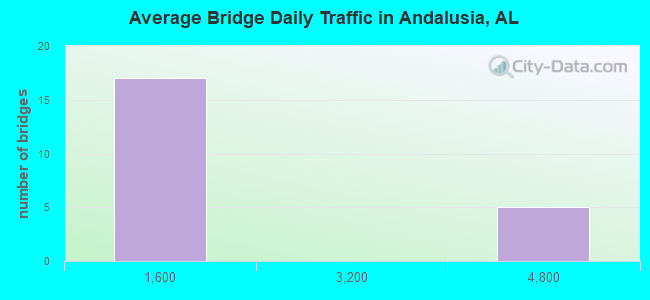
- 28,814Total average daily traffic
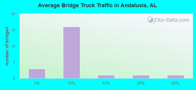
- 2,567Total average daily truck traffic
- 39,753Total future (year 2030) average daily traffic
- National Bridge Inventory (NBI) Registered Bridges for Andalusia
- No street view available for this location
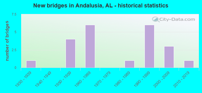
- New bridges - historical statistics
- 11930-1939
- 41950-1959
- 61960-1969
- 11980-1989
- 61990-1999
- 32000-2009
- 12010-2019
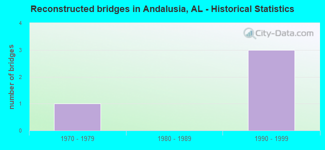
- Reconstructed bridges - Historical Statistics
- 11970-1979
- 01980-1989
- 31990-1999
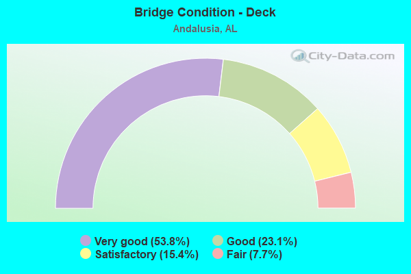
- Bridge Condition - Deck
- 53.8%Very good
- 23.1%Good
- 15.4%Satisfactory
- 7.7%Fair
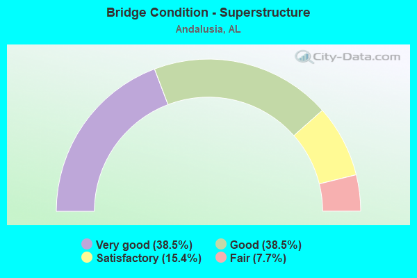
- Bridge Condition - Superstructure
- 38.5%Very good
- 38.5%Good
- 15.4%Satisfactory
- 7.7%Fair
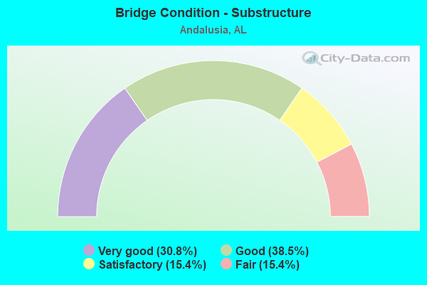
- Bridge Condition - Substructure
- 30.8%Very good
- 38.5%Good
- 15.4%Satisfactory
- 15.4%Fair
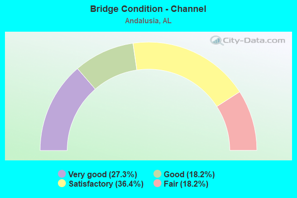
- Bridge Condition - Channel
- 27.3%Very good
- 18.2%Good
- 36.4%Satisfactory
- 18.2%Fair
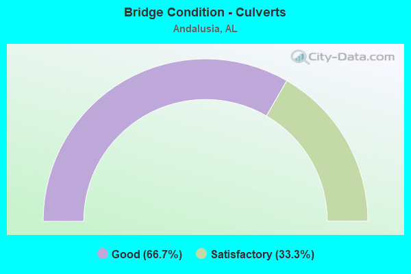
- Bridge Condition - Culverts
- 66.7%Good
- 33.3%Satisfactory
Find on map >> Show street view
Structure Number: 3734, Location: 1 MI N OF ANDALUSIA (Lat: 31.335197, Lng: -86.458547), Route carried "on" structure: County highway 33, Year Built: 1950, Status: Open, Structure Length: 0.64m (2.10ft), Average Daily Traffic: 110 (year 1994), Truck Traffic: 5%, Average Future Daily Traffic: 215 (year 2032), Design Load: H 15, Features Intersected: NO NAME BRANCH
Minimum Vertical Clearance: 30+ m (98+ ft), Kilometerpoint: 0.010, Lanes on structure: 2, Owner: County Highway Agency, Approaching Roadway Width: 8.5m (27.9ft), Material/Design: Concrete, Design/Construction: Culvert, Number Of Spans In Main Unit: 2, Length of Maximum Span: 3.0m (9.8ft)
Condition: Channel: Satisfactory, Culverts: Satisfactory, Operating Rating: 44.8 metric tons, Method Used To Determine Operating Rating: Load Factor (LF), Inventory Rating: 26.9 metric tons, Method Used To Determine Inventory Rating: Load Factor (LF), Structural Evaluation: Equal to present minimum criteria, Waterway Adequacy: Better than present minimum criteria, Approach Roadway Alignment: Better than present minimum criteria, Length Of Structure Improvement: 1.26m (4.13ft), Designated Inspection Frequency: Every 24 months, Inspection Date: Febuary 2022, Bridge Improvement Cost: $262,000, Roadway Improvement Cost: $26,000, Total Project Cost: $288,000 ( Estimate for 2022)
Find on map >> Show street view
Structure Number: 5981, Location: 1.5 MI. E. OF HEATH (Lat: 31.355814, Lng: -86.444144), Route carried "on" structure: County highway 70, Year Built: 1957, Status: Open, Structure Length: 0.64m (2.10ft), Average Daily Traffic: 280 (year 1994), Truck Traffic: 5%, Average Future Daily Traffic: 392 (year 2032), Design Load: H 15, Features Intersected: FIVE RUN CREEK
Minimum Vertical Clearance: 30+ m (98+ ft), Kilometerpoint: 0.000, Lanes on structure: 2, Owner: County Highway Agency, Approaching Roadway Width: 8.5m (27.9ft), Material/Design: Concrete, Design/Construction: Culvert, Number Of Spans In Main Unit: 2, Length of Maximum Span: 3.0m (9.8ft)
Condition: Channel: Satisfactory, Culverts: Good, Operating Rating: 85.3 metric tons, Method Used To Determine Operating Rating: Load Factor (LF), Inventory Rating: 51.2 metric tons, Method Used To Determine Inventory Rating: Load Factor (LF), Structural Evaluation: Better than present minimum criteria, Waterway Adequacy: Better than present minimum criteria, Approach Roadway Alignment: Better than present minimum criteria, Length Of Structure Improvement: 1.26m (4.13ft), Designated Inspection Frequency: Every 24 months, Inspection Date: Febuary 2022, Bridge Improvement Cost: $306,000, Roadway Improvement Cost: $31,000, Total Project Cost: $337,000 ( Estimate for 2022), Wearing Surface/Protective System: Wearing Surface: Bituminous
Find on map >> Show street view
Structure Number: 5982, Location: 1.7 MI. E. OF HEATH (Lat: 31.350461, Lng: -86.434892), Route carried "on" structure: County highway 70, Year Built: 1957, Status: Open, Structure Length: 1.13m (3.71ft), Average Daily Traffic: 280 (year 1994), Truck Traffic: 5%, Average Future Daily Traffic: 392 (year 2032), Design Load: H 15, Features Intersected: FIVE RUN CREEK
Minimum Vertical Clearance: 30+ m (98+ ft), Kilometerpoint: 0.000, Lanes on structure: 2, Owner: County Highway Agency, Approaching Roadway Width: 8.5m (27.9ft), Material/Design: Concrete, Design/Construction: Culvert, Number Of Spans In Main Unit: 3, Length of Maximum Span: 3.7m (12.1ft)
Condition: Channel: Satisfactory, Culverts: Good, Operating Rating: 76.7 metric tons, Method Used To Determine Operating Rating: Load Factor (LF), Inventory Rating: 46.1 metric tons, Method Used To Determine Inventory Rating: Load Factor (LF), Structural Evaluation: Better than present minimum criteria, Waterway Adequacy: Equal to present minimum criteria, Approach Roadway Alignment: Equal to present minimum criteria, Length Of Structure Improvement: 1.80m (5.91ft), Designated Inspection Frequency: Every 24 months, Inspection Date: Febuary 2022, Bridge Improvement Cost: $333,000, Roadway Improvement Cost: $33,000, Total Project Cost: $366,000 ( Estimate for 2022), Wearing Surface/Protective System: Wearing Surface: Bituminous
Find on map >> Show street view
Structure Number: 10588, Location: 2 MI N. OF LIBERTYVILLE (Lat: 31.266233, Lng: -86.451156), Route carried "on" structure: County highway 56, Year Built: 1961, Status: Open, Structure Length: 1.30m (4.27ft), Average Daily Traffic: 110 (year 1994), Truck Traffic: 5%, Average Future Daily Traffic: 143 (year 2030), Design Load: H 15, Features Intersected: N0 NAME CREEK
Minimum Vertical Clearance: 30+ m (98+ ft), Kilometerpoint: 0.000, Lanes on structure: 2, Owner: County Highway Agency, Approaching Roadway Width: 9.8m (32.2ft), Material/Design: Concrete, Design/Construction: Culvert, Number Of Spans In Main Unit: 4, Length of Maximum Span: 3.0m (9.8ft)
Condition: Channel: Satisfactory, Culverts: Good, Operating Rating: 88.9 metric tons, Method Used To Determine Operating Rating: Load Factor (LF), Inventory Rating: 77.5 metric tons, Method Used To Determine Inventory Rating: Load Factor (LF), Structural Evaluation: Better than present minimum criteria, Waterway Adequacy: Better than present minimum criteria, Approach Roadway Alignment: Equal to present desirable criteria, Length Of Structure Improvement: 1.97m (6.46ft), Designated Inspection Frequency: Every 24 months, Inspection Date: August 2020, Bridge Improvement Cost: $363,000, Roadway Improvement Cost: $36,000, Total Project Cost: $399,000 ( Estimate for 2022), Wearing Surface/Protective System: Wearing Surface: Bituminous
Find on map >> Show street view
Structure Number: 12767, Location: 5.2 MI.E.US 29 (Lat: 31.316564, Lng: -86.419428), Route carried "on" structure: US 84, Year Built: 1982, Status: Open, Structure Length: 5.18m (16.99ft), Average Daily Traffic: 4,150 (year 2013), Truck Traffic: 8%, Average Future Daily Traffic: 5,567 (year 2033), Design Load: HS 20, Features Intersected: FIVE RUN BRANCH
Minimum Vertical Clearance: 30+ m (98+ ft), Kilometerpoint: 220.356, Lanes on structure: 2, Base Highway Network: Yes, Owner: State Highway Agency, Approaching Roadway Width: 13.4m (44.0ft), Material/Design: Prestressed concrete continuous, Design/Construction: Stringer/Multi-beam, Number Of Spans In Main Unit: 5, Length of Maximum Span: 10.4m (34.1ft), Curb-To-Curb Width: 13.4m (44.0ft), Out-to-Out Width: 14.2m (46.6ft)
Condition: Deck: Good, Superstructure: Good, Substructure: Good, Channel: Satisfactory, Operating Rating: 74.3 metric tons, Method Used To Determine Operating Rating: Load Factor (LF), Inventory Rating: 44.5 metric tons, Method Used To Determine Inventory Rating: Load Factor (LF), Structural Evaluation: Better than present minimum criteria, Deck Geometry: Superior to present desirable criteria, Waterway Adequacy: Better than present minimum criteria, Approach Roadway Alignment: Equal to present desirable criteria, Length Of Structure Improvement: 6.21m (20.37ft), Designated Inspection Frequency: Every 24 months, Inspection Date: Febuary 2022, Bridge Improvement Cost: $1,957,000, Roadway Improvement Cost: $196,000, Total Project Cost: $2,153,000 ( Estimate for 2022), Deck Structure Type: Concrete Cast-file-Place
Find on map >> Show street view
Structure Number: 1288, Location: 3 MI EAST OF ANDALUSIA (Lat: 31.275625, Lng: -86.435522), Route carried "on" structure: County highway 45, Year Built: 1951, Year Reconstructed: 1983, Status: Open, Structure Length: 10.36m (33.99ft), Average Daily Traffic: 520 (year 1994), Truck Traffic: 5%, Average Future Daily Traffic: 673 (year 2030), Design Load: HS 20, Features Intersected: FIVE RUNS CREEK
Minimum Vertical Clearance: 30+ m (98+ ft), Kilometerpoint: 0.010, Lanes on structure: 2, Owner: County Highway Agency, Approaching Roadway Width: 11.0m (36.1ft), Material/Design: Concrete, Design/Construction: Channel Beam, Number Of Spans In Main Unit: 10, Length of Maximum Span: 10.4m (34.1ft), Curb-To-Curb Width: 8.5m (27.9ft), Out-to-Out Width: 9.3m (30.5ft)
Condition: Deck: Fair, Superstructure: Fair, Substructure: Fair, Channel: Fair, Operating Rating: 71.9 metric tons, Method Used To Determine Operating Rating: Allowable Stress (AS), Inventory Rating: 46.9 metric tons, Method Used To Determine Inventory Rating: Allowable Stress (AS), Structural Evaluation: Somewhat better than minimum adequacy, Deck Geometry: Somewhat better than minimum adequacy, Waterway Adequacy: Better than present minimum criteria, Approach Roadway Alignment: Better than present minimum criteria, Length Of Structure Improvement: 11.28m (37.01ft), Designated Inspection Frequency: Every 24 months, Inspection Date: March 2021, Bridge Improvement Cost: $2,320,000, Roadway Improvement Cost: $232,000, Total Project Cost: $2,552,000 ( Estimate for 2022), Deck Structure Type: Concrete Precast Panels
Find on map >> Show street view
Structure Number: 1498, Location: HENRY HUGGINS RD (Lat: 31.287803, Lng: -86.440661), Route carried "on" structure: County highway 101, Year Built: 1932, Year Reconstructed: 1990, Status: Open, Structure Length: 1.04m (3.41ft), Average Daily Traffic: 220 (year 1994), Truck Traffic: 5%, Average Future Daily Traffic: 292 (year 2030), Design Load: HS 20, Features Intersected: NO NAME BRANCH
Minimum Vertical Clearance: 30+ m (98+ ft), Kilometerpoint: 0.010, Lanes on structure: 2, Owner: County Highway Agency, Approaching Roadway Width: 8.5m (27.9ft), Material/Design: Concrete, Design/Construction: Channel Beam, Number Of Spans In Main Unit: 1, Length of Maximum Span: 10.4m (34.1ft), Curb-To-Curb Width: 7.5m (24.6ft), Out-to-Out Width: 8.2m (26.9ft)
Condition: Deck: Very good, Superstructure: Very good, Substructure: Good, Channel: Satisfactory, Operating Rating: 75.4 metric tons, Method Used To Determine Operating Rating: Load Factor (LF), Inventory Rating: 45.3 metric tons, Method Used To Determine Inventory Rating: Load Factor (LF), Structural Evaluation: Better than present minimum criteria, Deck Geometry: Somewhat better than minimum adequacy, Waterway Adequacy: Better than present minimum criteria, Approach Roadway Alignment: Better than present minimum criteria, Length Of Structure Improvement: 1.71m (5.61ft), Designated Inspection Frequency: Every 24 months, Inspection Date: August 2020, Bridge Improvement Cost: $316,000, Roadway Improvement Cost: $32,000, Total Project Cost: $348,000 ( Estimate for 2022), Deck Structure Type: Concrete Precast Panels
Find on map >> Show street view
Structure Number: 15023, Location: 2 MI NORTH EAST ANDALUSIA (Lat: 31.331258, Lng: -86.441814), Route carried "on" structure: County highway 49, Year Built: 1963, Year Reconstructed: 1990, Status: Open, Structure Length: 3.11m (10.20ft), Average Daily Traffic: 310 (year 1994), Truck Traffic: 5%, Average Future Daily Traffic: 556 (year 2032), Design Load: HS 20, Features Intersected: FIVE RUNS CREEK
Minimum Vertical Clearance: 30+ m (98+ ft), Kilometerpoint: 0.010, Lanes on structure: 2, Owner: County Highway Agency, Approaching Roadway Width: 9.8m (32.2ft), Material/Design: Concrete, Design/Construction: Channel Beam, Number Of Spans In Main Unit: 3, Length of Maximum Span: 10.4m (34.1ft), Curb-To-Curb Width: 8.5m (27.9ft), Out-to-Out Width: 9.3m (30.5ft)
Condition: Deck: Satisfactory, Superstructure: Good, Substructure: Fair, Channel: Good, Operating Rating: 74.1 metric tons, Method Used To Determine Operating Rating: Load Factor (LF), Inventory Rating: 44.5 metric tons, Method Used To Determine Inventory Rating: Load Factor (LF), Structural Evaluation: Somewhat better than minimum adequacy, Deck Geometry: Equal to present minimum criteria, Waterway Adequacy: Better than present minimum criteria, Approach Roadway Alignment: Better than present minimum criteria, Length Of Structure Improvement: 3.96m (12.99ft), Designated Inspection Frequency: Every 24 months, Inspection Date: Febuary 2022, Bridge Improvement Cost: $815,000, Roadway Improvement Cost: $82,000, Total Project Cost: $897,000 ( Estimate for 2022), Deck Structure Type: Concrete Precast Panels
Find on map >> Show street view
Structure Number: 15633, Location: 1 MI. N OF MT. PISGAH CH (Lat: 31.357656, Lng: -86.419942), Route carried "on" structure: County highway 57, Year Built: 1992, Status: Open, Structure Length: 0.64m (2.10ft), Average Daily Traffic: 220 (year 1994), Truck Traffic: 5%, Average Future Daily Traffic: 380 (year 2032), Design Load: HS 20, Features Intersected: NO NAME BRANCH
Minimum Vertical Clearance: 30+ m (98+ ft), Kilometerpoint: 0.010, Lanes on structure: 2, Owner: County Highway Agency, Approaching Roadway Width: 9.1m (29.9ft), Material/Design: Concrete, Design/Construction: Culvert, Number Of Spans In Main Unit: 2, Length of Maximum Span: 3.0m (9.8ft)
Condition: Channel: Good, Culverts: Good, Operating Rating: 88.9 metric tons, Method Used To Determine Operating Rating: Load Factor (LF), Inventory Rating: 61.9 metric tons, Method Used To Determine Inventory Rating: Load Factor (LF), Structural Evaluation: Better than present minimum criteria, Waterway Adequacy: Better than present minimum criteria, Approach Roadway Alignment: Better than present minimum criteria, Length Of Structure Improvement: 1.26m (4.13ft), Designated Inspection Frequency: Every 24 months, Inspection Date: Febuary 2022, Bridge Improvement Cost: $415,000, Roadway Improvement Cost: $42,000, Total Project Cost: $457,000 ( Estimate for 2022), Wearing Surface/Protective System: Wearing Surface: Bituminous
Find on map >> Show street view
Structure Number: 15636, Location: 1/2 MI. W OF ANDALUSIA (Lat: 31.308797, Lng: -86.531458), Route carried "on" structure: County highway , Year Built: 1992, Status: Open, Structure Length: 11.52m (37.80ft), Average Daily Traffic: 350 (year 1994), Truck Traffic: 10%, Average Future Daily Traffic: 585 (year 2030), Design Load: HS 20, Features Intersected: CONECUH RIVER, Facility Carried by Structure: COUNTY DIRT RD
Minimum Vertical Clearance: 30+ m (98+ ft), Kilometerpoint: 0.010, Lanes on structure: 2, Owner: County Highway Agency, Approaching Roadway Width: 11.0m (36.1ft), Material/Design: Prestressed concrete, Design/Construction: Stringer/Multi-beam, Number Of Spans In Main Unit: 1, Number Of Approach Spans: 7, Length of Maximum Span: 42.7m (140.1ft), Curb-To-Curb Width: 8.5m (27.9ft), Out-to-Out Width: 9.3m (30.5ft)
Condition: Deck: Satisfactory, Superstructure: Satisfactory, Substructure: Satisfactory, Channel: Fair, Operating Rating: 74.1 metric tons, Method Used To Determine Operating Rating: Load Factor (LF), Inventory Rating: 44.5 metric tons, Method Used To Determine Inventory Rating: Load Factor (LF), Structural Evaluation: Equal to present minimum criteria, Deck Geometry: Equal to present minimum criteria, Waterway Adequacy: Better than present minimum criteria, Approach Roadway Alignment: Somewhat better than minimum adequacy, Length Of Structure Improvement: 12.39m (40.65ft), Designated Inspection Frequency: Every 24 months, Inspection Date: April 2021, Bridge Improvement Cost: $2,549,000, Roadway Improvement Cost: $255,000, Total Project Cost: $2,804,000 ( Estimate for 2022), Deck Structure Type: Concrete Cast-file-Place
Find on map >> Show street view
Structure Number: 15877, Location: 0.7 MILES N CO.RD. 17 (Lat: 31.278097, Lng: -86.484500), Route carried "on" structure: US 29, Year Built: 1962, Year Reconstructed: 1999, Status: Open, Structure Length: 0.76m (2.49ft), Average Daily Traffic: 4,150 (year 2013), Truck Traffic: 19%, Average Future Daily Traffic: 5,656 (year 2033), Design Load: HS 20, Features Intersected: BAY BRANCH
Minimum Vertical Clearance: 30+ m (98+ ft), Kilometerpoint: 870.398, Lanes on structure: 2, Owner: State Highway Agency, Approaching Roadway Width: 7.9m (25.9ft), Material/Design: Concrete, Design/Construction: Culvert, Number Of Spans In Main Unit: 2, Length of Maximum Span: 3.7m (12.1ft)
Condition: Channel: Very good, Culverts: Satisfactory, Operating Rating: 57.9 metric tons, Method Used To Determine Operating Rating: Load Factor (LF), Inventory Rating: 34.7 metric tons, Method Used To Determine Inventory Rating: Load Factor (LF), Structural Evaluation: Equal to present minimum criteria, Waterway Adequacy: Better than present minimum criteria, Approach Roadway Alignment: Better than present minimum criteria, Length Of Structure Improvement: 1.41m (4.63ft), Designated Inspection Frequency: Every 24 months, Inspection Date: August 2021, Bridge Improvement Cost: $424,000, Roadway Improvement Cost: $42,000, Total Project Cost: $466,000 ( Estimate for 2022)
Find on map >> Show street view
Structure Number: 1588, Location: 4 MI. NE OF ANDALUSIA (Lat: 31.322447, Lng: -86.425378), Route carried "on" structure: County highway 57, Year Built: 1964, Status: Open, Structure Length: 0.64m (2.10ft), Average Daily Traffic: 250 (year 1994), Truck Traffic: 5%, Average Future Daily Traffic: 366 (year 2032), Design Load: H 15, Features Intersected: NO NAME BRANCH
Minimum Vertical Clearance: 30+ m (98+ ft), Kilometerpoint: 0.010, Lanes on structure: 2, Owner: County Highway Agency, Approaching Roadway Width: 8.5m (27.9ft), Material/Design: Concrete, Design/Construction: Culvert, Number Of Spans In Main Unit: 2, Length of Maximum Span: 3.0m (9.8ft)
Condition: Channel: Satisfactory, Culverts: Satisfactory, Operating Rating: 88.9 metric tons, Method Used To Determine Operating Rating: Load Factor (LF), Inventory Rating: 78.7 metric tons, Method Used To Determine Inventory Rating: Load Factor (LF), Structural Evaluation: Equal to present minimum criteria, Waterway Adequacy: Better than present minimum criteria, Approach Roadway Alignment: Equal to present minimum criteria, Length Of Structure Improvement: 1.26m (4.13ft), Designated Inspection Frequency: Every 24 months, Inspection Date: Febuary 2022, Bridge Improvement Cost: $335,000, Roadway Improvement Cost: $34,000, Total Project Cost: $369,000 ( Estimate for 2022), Wearing Surface/Protective System: Wearing Surface: Bituminous
Find on map >> Show street view
Structure Number: 16563, Location: 1MI N CO RD #42 (Lat: 31.307383, Lng: -86.525514), Route carried "on" structure: County highway 19, Year Built: 1996, Status: Open, Structure Length: 1.04m (3.41ft), Average Daily Traffic: 186 (year 1996), Truck Traffic: 20%, Average Future Daily Traffic: 236 (year 2035), Design Load: HS 20, Features Intersected: NO NAME BRANCH
Minimum Vertical Clearance: 30+ m (98+ ft), Kilometerpoint: 0.000, Lanes on structure: 2, Owner: County Highway Agency, Approaching Roadway Width: 8.5m (27.9ft), Material/Design: Concrete, Design/Construction: Channel Beam, Number Of Spans In Main Unit: 1, Length of Maximum Span: 10.4m (34.1ft), Curb-To-Curb Width: 7.5m (24.6ft), Out-to-Out Width: 8.2m (26.9ft)
Condition: Deck: Good, Superstructure: Good, Substructure: Good, Channel: Fair, Operating Rating: 74.1 metric tons, Method Used To Determine Operating Rating: Load Factor (LF), Inventory Rating: 44.5 metric tons, Method Used To Determine Inventory Rating: Load Factor (LF), Structural Evaluation: Better than present minimum criteria, Deck Geometry: Somewhat better than minimum adequacy, Waterway Adequacy: Better than present minimum criteria, Approach Roadway Alignment: Somewhat better than minimum adequacy, Length Of Structure Improvement: 1.71m (5.61ft), Designated Inspection Frequency: Every 24 months, Inspection Date: March 2020, Bridge Improvement Cost: $316,000, Roadway Improvement Cost: $32,000, Total Project Cost: $348,000 ( Estimate for 2022), Deck Structure Type: Concrete Precast Panels
Find on map >> Show street view
Structure Number: 17109, Location: 6.4KM S OF ANDALUSIA (Lat: 31.255619, Lng: -86.496606), Route carried "on" structure: County highway , Year Built: 1996, Status: Open, Structure Length: 2.07m (6.79ft), Average Daily Traffic: 186 (year 1996), Truck Traffic: 2%, Average Future Daily Traffic: 447 (year 2035), Design Load: HS 20, Features Intersected: BAY BRANCH, Facility Carried by Structure: ANN RABREN ROAD
Minimum Vertical Clearance: 30+ m (98+ ft), Kilometerpoint: 0.000, Lanes on structure: 2, Owner: County Highway Agency, Approaching Roadway Width: 8.5m (27.9ft), Material/Design: Concrete, Design/Construction: Channel Beam, Number Of Spans In Main Unit: 2, Length of Maximum Span: 10.4m (34.1ft), Curb-To-Curb Width: 7.5m (24.6ft), Out-to-Out Width: 8.2m (26.9ft)
Condition: Deck: Very good, Superstructure: Good, Substructure: Good, Channel: Satisfactory, Operating Rating: 75.2 metric tons, Method Used To Determine Operating Rating: Load Factor (LF), Inventory Rating: 45.2 metric tons, Method Used To Determine Inventory Rating: Load Factor (LF), Structural Evaluation: Better than present minimum criteria, Deck Geometry: Somewhat better than minimum adequacy, Waterway Adequacy: Better than present minimum criteria, Approach Roadway Alignment: Equal to present minimum criteria, Length Of Structure Improvement: 2.84m (9.32ft), Designated Inspection Frequency: Every 24 months, Inspection Date: April 2020, Bridge Improvement Cost: $526,000, Roadway Improvement Cost: $53,000, Total Project Cost: $579,000 ( Estimate for 2022), Deck Structure Type: Concrete Precast Panels
Find on map >> Show street view
Structure Number: 17165, Location: 4KM SOUTH OF ANDALUSIA (Lat: 31.257061, Lng: -86.497578), Route carried "on" structure: County highway 17, Year Built: 1960, Status: Open, Structure Length: 0.63m (2.07ft), Average Daily Traffic: 730 (year 1998), Truck Traffic: 2%, Average Future Daily Traffic: 974 (year 2032), Features Intersected: NO NAME CREEK
Minimum Vertical Clearance: 30+ m (98+ ft), Kilometerpoint: 0.000, Lanes on structure: 2, Owner: County Highway Agency, Approaching Roadway Width: 8.5m (27.9ft), Material/Design: Concrete, Design/Construction: Culvert, Number Of Spans In Main Unit: 2, Length of Maximum Span: 3.0m (9.8ft)
Condition: Channel: Good, Culverts: Good, Operating Rating: 59.4 metric tons, Method Used To Determine Operating Rating: Load Factor (LF), Inventory Rating: 35.7 metric tons, Method Used To Determine Inventory Rating: Load Factor (LF), Structural Evaluation: Better than present minimum criteria, Waterway Adequacy: Better than present minimum criteria, Approach Roadway Alignment: Better than present minimum criteria, Length Of Structure Improvement: 1.25m (4.10ft), Designated Inspection Frequency: Every 24 months, Inspection Date: Febuary 2022, Bridge Improvement Cost: $245,000, Roadway Improvement Cost: $25,000, Total Project Cost: $270,000 ( Estimate for 2022), Wearing Surface/Protective System: Wearing Surface: Bituminous
Find on map >> Show street view
Structure Number: 17227, Location: 1 M W ANDALUSIA S OF 42 (Lat: 31.282858, Lng: -86.529481), Route carried "on" structure: County highway 19, Year Built: 1999, Status: Open, Structure Length: 2.07m (6.79ft), Average Daily Traffic: 220 (year 1994), Truck Traffic: 6%, Average Future Daily Traffic: 345 (year 2035), Design Load: HS 20, Features Intersected: COKER CREEK
Minimum Vertical Clearance: 30+ m (98+ ft), Kilometerpoint: 0.014, Lanes on structure: 2, Owner: County Highway Agency, Approaching Roadway Width: 9.8m (32.2ft), Material/Design: Concrete, Design/Construction: Channel Beam, Number Of Spans In Main Unit: 2, Length of Maximum Span: 10.4m (34.1ft), Curb-To-Curb Width: 7.5m (24.6ft), Out-to-Out Width: 8.2m (26.9ft)
Condition: Deck: Good, Superstructure: Good, Substructure: Satisfactory, Channel: Very good, Operating Rating: 75.2 metric tons, Method Used To Determine Operating Rating: Load Factor (LF), Inventory Rating: 45.2 metric tons, Method Used To Determine Inventory Rating: Load Factor (LF), Structural Evaluation: Equal to present minimum criteria, Deck Geometry: Somewhat better than minimum adequacy, Waterway Adequacy: Equal to present desirable criteria, Approach Roadway Alignment: Equal to present minimum criteria, Length Of Structure Improvement: 2.84m (9.32ft), Designated Inspection Frequency: Every 24 months, Inspection Date: August 2021, Bridge Improvement Cost: $526,000, Roadway Improvement Cost: $53,000, Total Project Cost: $579,000 ( Estimate for 2022), Deck Structure Type: Concrete Precast Panels
Find on map >> Show street view
Structure Number: 17246, Location: 1 MI. S.E. ANDALUSIA (Lat: 31.271447, Lng: -86.430803), Route carried "on" structure: County highway 45, Year Built: 1999, Status: Open, Structure Length: 2.07m (6.79ft), Average Daily Traffic: 540 (year 1994), Truck Traffic: 7%, Average Future Daily Traffic: 689 (year 2035), Design Load: HS 20, Features Intersected: TURKEY CREEK
Minimum Vertical Clearance: 30+ m (98+ ft), Kilometerpoint: 0.142, Lanes on structure: 2, Owner: County Highway Agency, Approaching Roadway Width: 11.0m (36.1ft), Material/Design: Concrete, Design/Construction: Channel Beam, Number Of Spans In Main Unit: 2, Length of Maximum Span: 10.4m (34.1ft), Curb-To-Curb Width: 8.5m (27.9ft), Out-to-Out Width: 9.3m (30.5ft)
Condition: Deck: Very good, Superstructure: Satisfactory, Substructure: Good, Channel: Good, Operating Rating: 70.7 metric tons, Method Used To Determine Operating Rating: Load Factor (LF), Inventory Rating: 42.5 metric tons, Method Used To Determine Inventory Rating: Load Factor (LF), Structural Evaluation: Equal to present minimum criteria, Deck Geometry: Somewhat better than minimum adequacy, Waterway Adequacy: Better than present minimum criteria, Approach Roadway Alignment: Equal to present minimum criteria, Length Of Structure Improvement: 2.84m (9.32ft), Designated Inspection Frequency: Every 24 months, Inspection Date: August 2021, Bridge Improvement Cost: $584,000, Roadway Improvement Cost: $58,000, Total Project Cost: $642,000 ( Estimate for 2022), Deck Structure Type: Concrete Precast Panels
Find on map >> Show street view
Structure Number: 17979, Location: 5.2 MI. E. US 29 (Lat: 31.317125, Lng: -86.419733), Route carried "on" structure: US 84, Year Built: 2004, Status: Open, Structure Length: 6.40m (21.00ft), Average Daily Traffic: 4,150 (year 2013), Truck Traffic: 8%, Average Future Daily Traffic: 5,567 (year 2033), Design Load: HS 20, Features Intersected: FIVE RUN BRANCH
Minimum Vertical Clearance: 30+ m (98+ ft), Kilometerpoint: 220.356, Lanes on structure: 2, Base Highway Network: Yes, Owner: State Highway Agency, Approaching Roadway Width: 12.1m (39.7ft), Material/Design: Prestressed concrete continuous, Design/Construction: Stringer/Multi-beam, Number Of Spans In Main Unit: 6, Length of Maximum Span: 10.7m (35.1ft), Curb-To-Curb Width: 12.1m (39.7ft), Out-to-Out Width: 13.0m (42.7ft)
Condition: Deck: Very good, Superstructure: Very good, Substructure: Very good, Channel: Very good, Operating Rating: 66.1 metric tons, Method Used To Determine Operating Rating: Load Factor (LF), Inventory Rating: 39.6 metric tons, Method Used To Determine Inventory Rating: Load Factor (LF), Structural Evaluation: Equal to present desirable criteria, Deck Geometry: Better than present minimum criteria, Waterway Adequacy: Better than present minimum criteria, Approach Roadway Alignment: Equal to present desirable criteria, Length Of Structure Improvement: 7.44m (24.41ft), Designated Inspection Frequency: Every 24 months, Inspection Date: Febuary 2022, Bridge Improvement Cost: $2,143,000, Roadway Improvement Cost: $214,000, Total Project Cost: $2,357,000 ( Estimate for 2022), Deck Structure Type: Concrete Cast-file-Place
Find on map >> Show street view
Structure Number: 1798, Location: 4.2 MI. E. JCT US 29 (Lat: 31.319731, Lng: -86.435047), Route carried "on" structure: US 84, Year Built: 2005, Status: Open, Structure Length: 10.97m (35.99ft), Average Daily Traffic: 4,615 (year 2013), Truck Traffic: 8%, Average Future Daily Traffic: 6,191 (year 2033), Design Load: HS 20, Features Intersected: FIVE RUN CREEK
Minimum Vertical Clearance: 30+ m (98+ ft), Kilometerpoint: 218.826, Lanes on structure: 2, Base Highway Network: Yes, Owner: State Highway Agency, Approaching Roadway Width: 12.1m (39.7ft), Material/Design: Prestressed concrete continuous, Design/Construction: Stringer/Multi-beam, Number Of Spans In Main Unit: 8, Length of Maximum Span: 13.7m (44.9ft), Curb-To-Curb Width: 12.1m (39.7ft), Out-to-Out Width: 12.9m (42.3ft)
Condition: Deck: Very good, Superstructure: Very good, Substructure: Very good, Channel: Very good, Operating Rating: 54.0 metric tons, Method Used To Determine Operating Rating: Load Factor (LF), Inventory Rating: 33.1 metric tons, Method Used To Determine Inventory Rating: Load Factor (LF), Structural Evaluation: Equal to present desirable criteria, Deck Geometry: Better than present minimum criteria, Waterway Adequacy: Equal to present desirable criteria, Approach Roadway Alignment: Equal to present desirable criteria, Length Of Structure Improvement: 11.86m (38.91ft), Designated Inspection Frequency: Every 24 months, Inspection Date: Febuary 2022, Bridge Improvement Cost: $3,417,000, Roadway Improvement Cost: $342,000, Total Project Cost: $3,759,000 ( Estimate for 2022), Deck Structure Type: Concrete Cast-file-Place
Find on map >> Show street view
Structure Number: 17981, Location: 4.2 MI E. JCT. US 29 (Lat: 31.319511, Lng: -86.435086), Route carried "on" structure: US 84, Year Built: 2005, Status: Open, Structure Length: 10.97m (35.99ft), Average Daily Traffic: 4,615 (year 2013), Truck Traffic: 8%, Average Future Daily Traffic: 6,191 (year 2033), Design Load: HS 20, Features Intersected: FIVE RUN CREEK
Minimum Vertical Clearance: 30+ m (98+ ft), Kilometerpoint: 218.826, Lanes on structure: 2, Base Highway Network: Yes, Owner: State Highway Agency, Approaching Roadway Width: 12.1m (39.7ft), Material/Design: Prestressed concrete continuous, Design/Construction: Stringer/Multi-beam, Number Of Spans In Main Unit: 8, Length of Maximum Span: 13.7m (44.9ft), Curb-To-Curb Width: 12.1m (39.7ft), Out-to-Out Width: 12.9m (42.3ft)
Condition: Deck: Very good, Superstructure: Very good, Substructure: Very good, Channel: Very good, Operating Rating: 54.0 metric tons, Method Used To Determine Operating Rating: Load Factor (LF), Inventory Rating: 33.1 metric tons, Method Used To Determine Inventory Rating: Load Factor (LF), Structural Evaluation: Equal to present desirable criteria, Deck Geometry: Better than present minimum criteria, Waterway Adequacy: Equal to present desirable criteria, Approach Roadway Alignment: Equal to present desirable criteria, Length Of Structure Improvement: 11.86m (38.91ft), Designated Inspection Frequency: Every 24 months, Inspection Date: Febuary 2022, Bridge Improvement Cost: $3,417,000, Roadway Improvement Cost: $342,000, Total Project Cost: $3,759,000 ( Estimate for 2022), Deck Structure Type: Concrete Cast-file-Place
Find on map >> Show street view
Structure Number: 21666, Location: 0.33 Mile N of 84 By Pass (Lat: 31.325972, Lng: -86.489375), Route carried "on" structure: City street 68, Year Built: 1962, Status: Open, Structure Length: 0.61m (2.00ft), Average Daily Traffic: 1,158 (year 2020), Truck Traffic: 2%, Average Future Daily Traffic: 1,721 (year 2040), Design Load: HS 20, Features Intersected: Prestwood Creek, Facility Carried by Structure: Pinewood Drive
Minimum Vertical Clearance: 30+ m (98+ ft), Kilometerpoint: 0.000, Lanes on structure: 2, Owner: City or Municipal Highway Agency, Approaching Roadway Width: 9.8m (32.2ft), Material/Design: Concrete, Design/Construction: Culvert, Number Of Spans In Main Unit: 2, Length of Maximum Span: 3.0m (9.8ft)
Condition: Channel: Fair, Culverts: Good, Operating Rating: 54.0 metric tons, Method Used To Determine Operating Rating: Load Factor (LF), Inventory Rating: 32.3 metric tons, Method Used To Determine Inventory Rating: Load Factor (LF), Structural Evaluation: Better than present minimum criteria, Waterway Adequacy: Better than present minimum criteria, Approach Roadway Alignment: Better than present minimum criteria, Length Of Structure Improvement: 1.22m (4.00ft), Designated Inspection Frequency: Every 24 months, Inspection Date: September 2021, Bridge Improvement Cost: $239,000, Roadway Improvement Cost: $24,000, Total Project Cost: $263,000 ( Estimate for 2022), Wearing Surface/Protective System: Wearing Surface: Bituminous
Find on map >> Show street view
Structure Number: 21667, Location: 0.36 miles E of US 29 (Lat: 31.339436, Lng: -86.464894), Route carried "on" structure: City street , Year Built: 2010, Status: Open, Structure Length: 1.04m (3.41ft), Average Daily Traffic: 1,464 (year 2022), Truck Traffic: 7%, Average Future Daily Traffic: 2,175 (year 2042), Design Load: HS 20, Features Intersected: UT Five Runs Creek, Facility Carried by Structure: Industrial Park Dr
Minimum Vertical Clearance: 30+ m (98+ ft), Kilometerpoint: 0.000, Lanes on structure: 2, Owner: City or Municipal Highway Agency, Approaching Roadway Width: 11.0m (36.1ft), Material/Design: Concrete, Design/Construction: Channel Beam, Number Of Spans In Main Unit: 1, Length of Maximum Span: 10.4m (34.1ft), Curb-To-Curb Width: 8.5m (27.9ft), Out-to-Out Width: 9.3m (30.5ft)
Condition: Deck: Very good, Superstructure: Very good, Substructure: Very good, Channel: Very good, Operating Rating: 88.9 metric tons, Method Used To Determine Operating Rating: Load Factor (LF), Inventory Rating: 71.1 metric tons, Method Used To Determine Inventory Rating: Load Factor (LF), Structural Evaluation: Equal to present desirable criteria, Deck Geometry: Somewhat better than minimum adequacy, Waterway Adequacy: Equal to present desirable criteria, Approach Roadway Alignment: Equal to present desirable criteria, Length Of Structure Improvement: 1.71m (5.61ft), Designated Inspection Frequency: Every 24 months, Inspection Date: September 2021, Bridge Improvement Cost: $351,000, Roadway Improvement Cost: $35,000, Total Project Cost: $386,000 ( Estimate for 2022), Deck Structure Type: Concrete Precast Panels