Bridge Statistics for Anderson, Missouri (MO)
Condition, Traffic, Stress, Structural Evaluation, Project Costs
- National Bridge Inventory (NBI) Statistics
- 35Number of bridges
- 545ft / 166mTotal length
- $3,314,000Total costs
- 140,852Total average daily traffic
- 31,671Total average daily truck traffic
- National Bridge Inventory (NBI) Registered Bridges for Anderson
- No street view available for this location
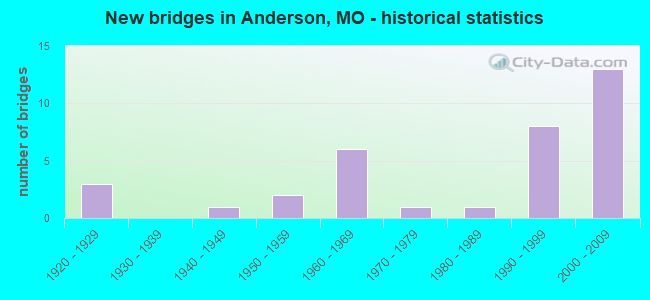
- New bridges - historical statistics
- 31920-1929
- 11940-1949
- 21950-1959
- 61960-1969
- 11970-1979
- 11980-1989
- 81990-1999
- 132000-2009

- Reconstructed bridges - Historical Statistics
- 11960-1969
- 01970-1979
- 01980-1989
- 01990-1999
- 12000-2009


- Bridge Condition - Deck
- 23.5%Very good
- 29.4%Good
- 35.3%Satisfactory
- 11.8%Fair

- Bridge Condition - Superstructure
- 5.9%Excellent
- 29.4%Good
- 35.3%Satisfactory
- 23.5%Fair
- 5.9%Poor

- Bridge Condition - Substructure
- 5.9%Very good
- 47.1%Good
- 35.3%Satisfactory
- 11.8%Poor

- Bridge Condition - Channel
- 4.8%Very good
- 9.5%Good
- 28.6%Satisfactory
- 47.6%Fair
- 9.5%Poor

- Bridge Condition - Culverts
- 25.0%Good
- 62.5%Satisfactory
- 12.5%Fair
Find on map >> Show street view
Structure Number: 1158, Location: S 7 T 22 N R 32 W (Lat: 36.648242, Lng: -94.433769), Route carried "on" structure: State highway 76, Year Built: 1965, Status: Open, Structure Length: 13.32m (43.70ft), Average Daily Traffic: 7,555 (year 2021), Truck Traffic: 11%, Average Future Daily Traffic: 15,866 (year 2041), Design Load: H 20, Features Intersected: INDIAN CR
Minimum Vertical Clearance: 30+ m (98+ ft), Kilometerpoint: 20.123, Lanes on structure: 2, Base Highway Network: Yes, Owner: State Highway Agency, Approaching Roadway Width: 13.4m (44.0ft), Material/Design: Steel continuous, Design/Construction: Stringer/Multi-beam, Number Of Spans In Main Unit: 3, Number Of Approach Spans: 2, Length of Maximum Span: 39.6m (129.9ft), Curb-To-Curb Width: 9.1m (29.9ft), Out-to-Out Width: 9.9m (32.5ft)
Condition: Deck: Satisfactory, Superstructure: Fair, Substructure: Satisfactory, Channel: Fair, Operating Rating: 36.9 metric tons, Method Used To Determine Operating Rating: Allowable Stress (AS), Inventory Rating: 21.6 metric tons, Method Used To Determine Inventory Rating: Allowable Stress (AS), Structural Evaluation: Somewhat better than minimum adequacy, Deck Geometry: Meets minimum limits, Waterway Adequacy: Equal to present desirable criteria, Approach Roadway Alignment: Equal to present desirable criteria, Designated Inspection Frequency: Every 24 months, Other Special Inspection Frequency: Every 24 months, Inspection Date: Febuary 2022, Other Special Inspection Date: Febuary 2022, Deck Structure Type: Concrete Cast-file-Place, Wearing Surface/Protective System: Wearing Surface: Bituminous
Find on map >> Show street view
Structure Number: 1159, Location: S 18 T 22 N R 32 W (Lat: 36.639475, Lng: -94.426511), Route carried "on" structure: Business State highway 71, Year Built: 1965, Status: Open, Structure Length: 7.44m (24.41ft), Average Daily Traffic: 3,220 (year 2021), Truck Traffic: 11%, Average Future Daily Traffic: 6,762 (year 2041), Design Load: H 20, Features Intersected: THIEF HOLLOW
Minimum Vertical Clearance: 30+ m (98+ ft), Kilometerpoint: 10.153, Lanes on structure: 2, Base Highway Network: Yes, Owner: State Highway Agency, Approaching Roadway Width: 13.4m (44.0ft), Skew: 3 degrees, Material/Design: Steel continuous, Design/Construction: Stringer/Multi-beam, Number Of Spans In Main Unit: 2, Number Of Approach Spans: 1, Length of Maximum Span: 29.3m (96.1ft), Curb-To-Curb Width: 9.1m (29.9ft), Out-to-Out Width: 10.1m (33.1ft)
Condition: Deck: Satisfactory, Superstructure: Fair, Substructure: Satisfactory, Channel: Very good, Operating Rating: 36.9 metric tons, Method Used To Determine Operating Rating: Allowable Stress (AS), Inventory Rating: 22.5 metric tons, Method Used To Determine Inventory Rating: Allowable Stress (AS), Structural Evaluation: Somewhat better than minimum adequacy, Deck Geometry: Meets minimum limits, Waterway Adequacy: Equal to present desirable criteria, Approach Roadway Alignment: Equal to present desirable criteria, Designated Inspection Frequency: Every 24 months, Inspection Date: October 2020, Deck Structure Type: Concrete Cast-file-Place, Wearing Surface/Protective System: Wearing Surface: Bituminous
Find on map >> Show street view
Structure Number: 11794, Location: S 32 T 23 N R 32 W (Lat: 36.680300, Lng: -94.419086), Route carried "on" structure: Interstate 49, Year Built: 2000, Status: Open, Structure Length: 9.33m (30.61ft), Average Daily Traffic: 6,023 (year 2021), Truck Traffic: 30%, Average Future Daily Traffic: 10,540 (year 2041), Design Load: HS 20+Mod, Features Intersected: RT NN
Minimum Vertical Clearance: 30+ m (98+ ft), Kilometerpoint: 21.113, Lanes on structure: 2, Lanes under structure: 2, Base Highway Network: Yes, Owner: State Highway Agency, Approaching Roadway Width: 11.3m (37.1ft), Skew: 2 degrees, Material/Design: Prestressed concrete continuous, Design/Construction: Tee Beam, Number Of Spans In Main Unit: 3, Length of Maximum Span: 31.2m (102.4ft), Curb-To-Curb Width: 11.4m (37.4ft), Out-to-Out Width: 12.2m (40.0ft)
Condition: Deck: Good, Superstructure: Satisfactory, Substructure: Good, Operating Rating: 83.7 metric tons, Method Used To Determine Operating Rating: Load Factor (LF), Inventory Rating: 45.0 metric tons, Method Used To Determine Inventory Rating: Load Factor (LF), Structural Evaluation: Equal to present minimum criteria, Deck Geometry: Somewhat better than minimum adequacy, Underclear: Superior to present desirable criteria, Approach Roadway Alignment: Equal to present desirable criteria, Designated Inspection Frequency: Every 24 months, Inspection Date: October 2020, Deck Structure Type: Concrete Cast-file-Place, Wearing Surface/Protective System: Wearing Surface: Monolithic Concrete, Deck Protection: Epoxy Coated Reinforcing
Find on map >> Show street view
Structure Number: 11795, Location: S 32 T 23 N R 32 W (Lat: 36.680231, Lng: -94.419356), Route carried "on" structure: Interstate 49, Year Built: 2000, Status: Open, Structure Length: 9.33m (30.61ft), Average Daily Traffic: 6,046 (year 2021), Truck Traffic: 30%, Average Future Daily Traffic: 10,581 (year 2041), Design Load: HS 20+Mod, Features Intersected: RT NN
Minimum Vertical Clearance: 30+ m (98+ ft), Kilometerpoint: 274.918, Lanes on structure: 2, Lanes under structure: 2, Base Highway Network: Yes, Owner: State Highway Agency, Approaching Roadway Width: 11.3m (37.1ft), Skew: 2 degrees, Material/Design: Prestressed concrete continuous, Design/Construction: Tee Beam, Number Of Spans In Main Unit: 3, Length of Maximum Span: 31.2m (102.4ft), Curb-To-Curb Width: 11.4m (37.4ft), Out-to-Out Width: 12.2m (40.0ft)
Condition: Deck: Good, Superstructure: Satisfactory, Substructure: Good, Operating Rating: 83.7 metric tons, Method Used To Determine Operating Rating: Load Factor (LF), Inventory Rating: 45.0 metric tons, Method Used To Determine Inventory Rating: Load Factor (LF), Structural Evaluation: Equal to present minimum criteria, Deck Geometry: Somewhat better than minimum adequacy, Underclear: Superior to present desirable criteria, Approach Roadway Alignment: Equal to present desirable criteria, Designated Inspection Frequency: Every 24 months, Inspection Date: October 2020, Deck Structure Type: Concrete Cast-file-Place, Wearing Surface/Protective System: Wearing Surface: Monolithic Concrete, Deck Protection: Epoxy Coated Reinforcing
Find on map >> Show street view
Structure Number: 11796, Location: S 8 T 22 N R 32 W (Lat: 36.657261, Lng: -94.419839), Route carried "on" structure: Interstate 49, Year Built: 1999, Status: Open, Structure Length: 22.28m (73.10ft), Average Daily Traffic: 6,023 (year 2021), Truck Traffic: 30%, Average Future Daily Traffic: 10,540 (year 2041), Design Load: HS 20+Mod, Features Intersected: CRD INDIAN CRK RD, IND
Minimum Vertical Clearance: 30+ m (98+ ft), Kilometerpoint: 18.491, Lanes on structure: 2, Lanes under structure: 2, Base Highway Network: Yes, Owner: State Highway Agency, Approaching Roadway Width: 11.3m (37.1ft), Skew: 3 degrees, Material/Design: Steel continuous, Design/Construction: Stringer/Multi-beam, Number Of Spans In Main Unit: 5, Length of Maximum Span: 50.0m (164.0ft), Curb-To-Curb Width: 11.4m (37.4ft), Out-to-Out Width: 12.2m (40.0ft)
Condition: Deck: Satisfactory, Superstructure: Satisfactory, Substructure: Good, Channel: Fair, Operating Rating: 81.9 metric tons, Method Used To Determine Operating Rating: Load Factor (LF), Inventory Rating: 48.6 metric tons, Method Used To Determine Inventory Rating: Load Factor (LF), Structural Evaluation: Equal to present minimum criteria, Deck Geometry: Somewhat better than minimum adequacy, Underclear: Superior to present desirable criteria, Waterway Adequacy: Superior to present desirable criteria, Approach Roadway Alignment: Equal to present desirable criteria, Designated Inspection Frequency: Every 24 months, Inspection Date: January 2022, Deck Structure Type: Concrete Cast-file-Place, Wearing Surface/Protective System: Wearing Surface: Monolithic Concrete, Deck Protection: Epoxy Coated Reinforcing
Find on map >> Show street view
Structure Number: 11797, Location: S 8 T 22 N R 32 W (Lat: 36.648494, Lng: -94.419767), Route carried "on" structure: State highway 76, Year Built: 1999, Status: Open, Structure Length: 8.32m (27.30ft), Average Daily Traffic: 2,131 (year 2021), Truck Traffic: 10%, Average Future Daily Traffic: 3,729 (year 2041), Design Load: HS 20, Features Intersected: IS 49
Minimum Vertical Clearance: 30+ m (98+ ft), Kilometerpoint: 21.585, Lanes on structure: 2, Lanes under structure: 4, Owner: State Highway Agency, Approaching Roadway Width: 13.1m (43.0ft), Material/Design: Steel continuous, Design/Construction: Stringer/Multi-beam, Number Of Spans In Main Unit: 2, Length of Maximum Span: 34.3m (112.5ft), Curb-To-Curb Width: 13.2m (43.3ft), Out-to-Out Width: 14.0m (45.9ft)
Condition: Deck: Good, Superstructure: Good, Substructure: Good, Operating Rating: 57.6 metric tons, Method Used To Determine Operating Rating: Load Factor (LF), Inventory Rating: 34.2 metric tons, Method Used To Determine Inventory Rating: Load Factor (LF), Structural Evaluation: Better than present minimum criteria, Deck Geometry: Equal to present minimum criteria, Underclear: Better than present minimum criteria, Approach Roadway Alignment: Equal to present desirable criteria, Designated Inspection Frequency: Every 24 months, Inspection Date: October 2020, Deck Structure Type: Concrete Cast-file-Place, Wearing Surface/Protective System: Wearing Surface: Monolithic Concrete, Deck Protection: Epoxy Coated Reinforcing
Find on map >> Show street view
Structure Number: 12007, Location: S 8 T 22 N R 32 W (Lat: 36.657100, Lng: -94.420125), Route carried "on" structure: Interstate 49, Year Built: 1998, Status: Open, Structure Length: 22.28m (73.10ft), Average Daily Traffic: 6,046 (year 2021), Truck Traffic: 30%, Average Future Daily Traffic: 10,581 (year 2041), Design Load: HS 25 or greater, Features Intersected: CRD INDIAN CRK RD, IND
Minimum Vertical Clearance: 30+ m (98+ ft), Kilometerpoint: 277.421, Lanes on structure: 2, Lanes under structure: 2, Base Highway Network: Yes, Owner: State Highway Agency, Approaching Roadway Width: 11.3m (37.1ft), Skew: 3 degrees, Material/Design: Steel continuous, Design/Construction: Stringer/Multi-beam, Number Of Spans In Main Unit: 5, Length of Maximum Span: 50.0m (164.0ft), Curb-To-Curb Width: 11.4m (37.4ft), Out-to-Out Width: 12.2m (40.0ft)
Condition: Deck: Satisfactory, Superstructure: Satisfactory, Substructure: Satisfactory, Channel: Fair, Operating Rating: 81.9 metric tons, Method Used To Determine Operating Rating: Load Factor (LF), Inventory Rating: 48.6 metric tons, Method Used To Determine Inventory Rating: Load Factor (LF), Structural Evaluation: Equal to present minimum criteria, Deck Geometry: Somewhat better than minimum adequacy, Underclear: Superior to present desirable criteria, Waterway Adequacy: Superior to present desirable criteria, Approach Roadway Alignment: Equal to present desirable criteria, Designated Inspection Frequency: Every 24 months, Inspection Date: January 2022, Deck Structure Type: Concrete Cast-file-Place, Wearing Surface/Protective System: Wearing Surface: Monolithic Concrete, Deck Protection: Epoxy Coated Reinforcing
Find on map >> Show street view
Structure Number: 12008, Location: S 17 T 22 N R 32 W (Lat: 36.642403, Lng: -94.419194), Route carried "on" structure: Interstate 49, Year Built: 2001, Status: Open, Structure Length: 12.86m (42.19ft), Average Daily Traffic: 6,925 (year 2021), Truck Traffic: 30%, Average Future Daily Traffic: 12,119 (year 2041), Design Load: HS 25 or greater, Features Intersected: CRD CEDAR RD, THIEF HO
Minimum Vertical Clearance: 30+ m (98+ ft), Kilometerpoint: 16.887, Lanes on structure: 2, Lanes under structure: 2, Base Highway Network: Yes, Owner: State Highway Agency, Approaching Roadway Width: 11.3m (37.1ft), Material/Design: Prestressed concrete continuous, Design/Construction: Tee Beam, Number Of Spans In Main Unit: 4, Length of Maximum Span: 33.6m (110.2ft), Curb-To-Curb Width: 11.4m (37.4ft), Out-to-Out Width: 12.2m (40.0ft)
Condition: Deck: Very good, Superstructure: Good, Substructure: Good, Channel: Good, Operating Rating: 98.1 metric tons, Method Used To Determine Operating Rating: Load Factor (LF), Inventory Rating: 48.6 metric tons, Method Used To Determine Inventory Rating: Load Factor (LF), Structural Evaluation: Better than present minimum criteria, Deck Geometry: Somewhat better than minimum adequacy, Waterway Adequacy: Superior to present desirable criteria, Approach Roadway Alignment: Equal to present desirable criteria, Designated Inspection Frequency: Every 24 months, Inspection Date: October 2020, Deck Structure Type: Concrete Cast-file-Place, Wearing Surface/Protective System: Wearing Surface: Monolithic Concrete, Deck Protection: Epoxy Coated Reinforcing
Find on map >> Show street view
Structure Number: 12009, Location: S 17 T 22 N R 32 W (Lat: 36.642392, Lng: -94.419469), Route carried "on" structure: Interstate 49, Year Built: 2001, Status: Open, Structure Length: 12.86m (42.19ft), Average Daily Traffic: 5,291 (year 2021), Truck Traffic: 30%, Average Future Daily Traffic: 9,259 (year 2041), Design Load: HS 20+Mod, Features Intersected: CRD CEDAR RD, THIEF HO
Minimum Vertical Clearance: 30+ m (98+ ft), Kilometerpoint: 279.101, Lanes on structure: 2, Lanes under structure: 2, Base Highway Network: Yes, Owner: State Highway Agency, Approaching Roadway Width: 11.3m (37.1ft), Material/Design: Prestressed concrete continuous, Design/Construction: Tee Beam, Number Of Spans In Main Unit: 4, Length of Maximum Span: 33.6m (110.2ft), Curb-To-Curb Width: 11.4m (37.4ft), Out-to-Out Width: 12.2m (40.0ft)
Condition: Deck: Very good, Superstructure: Good, Substructure: Very good, Channel: Good, Operating Rating: 92.7 metric tons, Method Used To Determine Operating Rating: Load Factor (LF), Inventory Rating: 45.0 metric tons, Method Used To Determine Inventory Rating: Load Factor (LF), Structural Evaluation: Better than present minimum criteria, Deck Geometry: Somewhat better than minimum adequacy, Waterway Adequacy: Superior to present desirable criteria, Approach Roadway Alignment: Equal to present desirable criteria, Designated Inspection Frequency: Every 24 months, Inspection Date: October 2020, Deck Structure Type: Concrete Cast-file-Place, Wearing Surface/Protective System: Wearing Surface: Monolithic Concrete, Deck Protection: Epoxy Coated Reinforcing
Find on map >> Show street view
Structure Number: 12081, Location: S 20 T 22 N R 32 W (Lat: 36.623881, Lng: -94.415642), Route carried "on" structure: Business State highway 71, Year Built: 2001, Status: Open, Structure Length: 11.77m (38.62ft), Average Daily Traffic: 3,220 (year 2021), Truck Traffic: 11%, Average Future Daily Traffic: 6,762 (year 2041), Design Load: HS 20, Features Intersected: IS 49
Minimum Vertical Clearance: 30+ m (98+ ft), Kilometerpoint: 12.171, Lanes on structure: 2, Lanes under structure: 4, Base Highway Network: Yes, Owner: State Highway Agency, Approaching Roadway Width: 11.9m (39.0ft), Skew: 4 degrees, Material/Design: Steel continuous, Design/Construction: Stringer/Multi-beam, Number Of Spans In Main Unit: 4, Length of Maximum Span: 36.5m (119.8ft), Curb-To-Curb Width: 12.0m (39.4ft), Out-to-Out Width: 12.8m (42.0ft)
Condition: Deck: Satisfactory, Superstructure: Satisfactory, Substructure: Good, Operating Rating: 60.3 metric tons, Method Used To Determine Operating Rating: Load Factor (LF), Inventory Rating: 36.0 metric tons, Method Used To Determine Inventory Rating: Load Factor (LF), Structural Evaluation: Equal to present minimum criteria, Deck Geometry: Somewhat better than minimum adequacy, Underclear: Better than present minimum criteria, Approach Roadway Alignment: Equal to present desirable criteria, Designated Inspection Frequency: Every 24 months, Inspection Date: October 2020, Deck Structure Type: Concrete Cast-file-Place, Wearing Surface/Protective System: Wearing Surface: Monolithic Concrete, Deck Protection: Epoxy Coated Reinforcing
Find on map >> Show street view
Structure Number: 1239, Location: S 4 T 44 N R 31 W (Lat: 38.638592, Lng: -94.355833), Route carried "on" structure: Interstate 49, Year Built: 1965, Year Reconstructed: 1969, Status: Open, Structure Length: 1.40m (4.59ft), Average Daily Traffic: 42,518 (year 2021), Truck Traffic: 22%, Average Future Daily Traffic: 74,407 (year 2041), Design Load: HS 20, Features Intersected: MUDDY CR
Minimum Vertical Clearance: 30+ m (98+ ft), Kilometerpoint: 40.168, Lanes on structure: 6, Base Highway Network: Yes, Owner: State Highway Agency, Approaching Roadway Width: 12.2m (40.0ft), Skew: 22 degrees, Material/Design: Concrete continuous, Design/Construction: Culvert, Number Of Spans In Main Unit: 3, Length of Maximum Span: 4.0m (13.1ft)
Condition: Channel: Satisfactory, Culverts: Satisfactory, Inventory Rating: 76.5 metric tons, Method Used To Determine Inventory Rating: Load Factor (LF), Structural Evaluation: Equal to present minimum criteria, Waterway Adequacy: Equal to present minimum criteria, Approach Roadway Alignment: Equal to present desirable criteria, Designated Inspection Frequency: Every 24 months, Inspection Date: November 2021
Find on map >> Show street view
Structure Number: 1239, Location: S 12 T 22 N R 33 W (Lat: 36.650914, Lng: -94.443147), Route carried "on" structure: City street 9, Year Built: 1962, Status: Open, Structure Length: 1.52m (4.99ft), Average Daily Traffic: 600 (year 2020), Truck Traffic: 10%, Average Future Daily Traffic: 900 (year 2040), Features Intersected: BEAVER CR, Facility Carried by Structure: MAIN ST
Minimum Vertical Clearance: 30+ m (98+ ft), Kilometerpoint: 0.161, Lanes on structure: 2, Owner: City or Municipal Highway Agency, Approaching Roadway Width: 7.3m (24.0ft), Material/Design: Steel, Design/Construction: Stringer/Multi-beam, Number Of Spans In Main Unit: 2, Length of Maximum Span: 7.6m (24.9ft), Curb-To-Curb Width: 6.9m (22.6ft), Out-to-Out Width: 8.5m (27.9ft)
Condition: Deck: Fair, Superstructure: Fair, Substructure: Satisfactory, Channel: Fair, Operating Rating: 55.8 metric tons, Method Used To Determine Operating Rating: Allowable Stress (AS), Inventory Rating: 30.6 metric tons, Method Used To Determine Inventory Rating: Allowable Stress (AS), Structural Evaluation: Somewhat better than minimum adequacy, Deck Geometry: Meets minimum limits, Waterway Adequacy: Somewhat better than minimum adequacy, Approach Roadway Alignment: Equal to present minimum criteria, Designated Inspection Frequency: Every 24 months, Inspection Date: Febuary 2022, Deck Structure Type: Concrete Cast-file-Place, Wearing Surface/Protective System: Wearing Surface: Bituminous
Find on map >> Show street view
Structure Number: 19197, Location: S 12 T 22 N R 33 W (Lat: 36.641447, Lng: -94.422394), Route carried "on" structure: County highway 214, Year Built: 1990, Status: Open, Structure Length: 1.10m (3.61ft), Average Daily Traffic: 10 (year 2020), Truck Traffic: 10%, Average Future Daily Traffic: 15 (year 2040), Features Intersected: THEIF HOLLOW, Facility Carried by Structure: PERSIMMON LN
Minimum Vertical Clearance: 30+ m (98+ ft), Kilometerpoint: 0.161, Lanes on structure: 1, Owner: County Highway Agency, Approaching Roadway Width: 4.9m (16.1ft), Material/Design: Concrete, Design/Construction: Slab, Number Of Spans In Main Unit: 2, Length of Maximum Span: 5.2m (17.1ft), Curb-To-Curb Width: 4.3m (14.1ft), Out-to-Out Width: 4.3m (14.1ft)
Condition: Deck: Good, Superstructure: Good, Substructure: Satisfactory, Channel: Satisfactory, Operating Rating: 43.2 metric tons, Method Used To Determine Operating Rating: Load Factor (LF), Inventory Rating: 25.2 metric tons, Method Used To Determine Inventory Rating: Load Factor (LF), Structural Evaluation: Equal to present minimum criteria, Deck Geometry: Equal to present minimum criteria, Waterway Adequacy: Meets minimum limits, Approach Roadway Alignment: Equal to present desirable criteria, Designated Inspection Frequency: Every 24 months, Inspection Date: Febuary 2022, Deck Structure Type: Concrete Cast-file-Place, Wearing Surface/Protective System: Wearing Surface: Monolithic Concrete
Find on map >> Show street view
Structure Number: 28662, Location: S 12 T 22 N R 33 W (Lat: 36.646356, Lng: -94.447400), Route carried "on" structure: County highway 209, Year Built: 2002, Status: Open, Structure Length: 8.32m (27.30ft), Average Daily Traffic: 100 (year 2020), Truck Traffic: 10%, Average Future Daily Traffic: 150 (year 2040), Design Load: HS 20, Features Intersected: INDIAN CR, Facility Carried by Structure: CANNING FACTORY RD
Minimum Vertical Clearance: 30+ m (98+ ft), Kilometerpoint: 0.161, Lanes on structure: 2, Owner: County Highway Agency, Approaching Roadway Width: 7.0m (23.0ft), Material/Design: Prestressed concrete continuous, Design/Construction: Stringer/Multi-beam, Number Of Spans In Main Unit: 3, Length of Maximum Span: 27.4m (89.9ft), Curb-To-Curb Width: 7.3m (24.0ft), Out-to-Out Width: 7.5m (24.6ft)
Condition: Deck: Good, Superstructure: Excellent, Substructure: Satisfactory, Channel: Poor, Operating Rating: 55.8 metric tons, Method Used To Determine Operating Rating: Load Factor (LF), Inventory Rating: 33.3 metric tons, Method Used To Determine Inventory Rating: Load Factor (LF), Structural Evaluation: Equal to present minimum criteria, Deck Geometry: Equal to present minimum criteria, Waterway Adequacy: Equal to present desirable criteria, Approach Roadway Alignment: Equal to present minimum criteria, Designated Inspection Frequency: Every 24 months, Inspection Date: Febuary 2022, Deck Structure Type: Concrete Cast-file-Place, Wearing Surface/Protective System: Wearing Surface: Monolithic Concrete
Find on map >> Show street view
Structure Number: 30209, Location: S 18 T 22 N R 32 W (Lat: 36.641200, Lng: -94.429286), Route carried "on" structure: County highway , Year Built: 1929, Status: Open, Structure Length: 9.51m (31.20ft), Average Daily Traffic: 1,500 (year 2020), Truck Traffic: 10%, Average Future Daily Traffic: 2,250 (year 2040), Design Load: HS 15, Features Intersected: INDIAN RVR, Facility Carried by Structure: CEDAR RD
Minimum Vertical Clearance: 30+ m (98+ ft), Kilometerpoint: 0.000, Lanes on structure: 2, Owner: County Highway Agency, Approaching Roadway Width: 6.7m (22.0ft), Material/Design: Concrete continuous, Design/Construction: Arch - Deck, Number Of Spans In Main Unit: 3, Length of Maximum Span: 30.5m (100.1ft), Curb-To-Curb Width: 6.1m (20.0ft), Out-to-Out Width: 7.0m (23.0ft)
Condition: Deck: Fair, Superstructure: Fair, Substructure: Poor, Channel: Fair, Operating Rating: 21.6 metric tons, Method Used To Determine Operating Rating: Allowable Stress (AS), Inventory Rating: 13.5 metric tons, Method Used To Determine Inventory Rating: Allowable Stress (AS), Structural Evaluation: Meets minimum limits, Deck Geometry: High priority of replacement, Waterway Adequacy: Equal to present desirable criteria, Approach Roadway Alignment: Equal to present desirable criteria, Length Of Structure Improvement: 1.05m (3.44ft), Designated Inspection Frequency: Every 24 months, Inspection Date: Febuary 2022, Bridge Improvement Cost: $1,321,000, Roadway Improvement Cost: $132,000, Total Project Cost: $1,981,000 ( Estimate for 2022), Deck Structure Type: Concrete Cast-file-Place, Wearing Surface/Protective System: Wearing Surface: Bituminous
Find on map >> Show street view
Structure Number: 31463, Location: S 12 T 22 N R 33 W (Lat: 36.658950, Lng: -94.445453), Route carried "on" structure: City street 9, Year Built: 2005, Status: Open, Structure Length: 0.80m (2.62ft), Average Daily Traffic: 150 (year 2020), Truck Traffic: 10%, Average Future Daily Traffic: 225 (year 2040), Features Intersected: BEAVER BR, Facility Carried by Structure: SELLERS RD
Minimum Vertical Clearance: 30+ m (98+ ft), Kilometerpoint: 0.000, Lanes on structure: 2, Owner: City or Municipal Highway Agency, Approaching Roadway Width: 4.6m (15.1ft), Material/Design: Steel continuous, Design/Construction: Culvert, Number Of Spans In Main Unit: 3, Length of Maximum Span: 2.6m (8.5ft), Curb-To-Curb Width: 5.2m (17.1ft), Out-to-Out Width: 5.5m (18.0ft)
Condition: Channel: Satisfactory, Culverts: Good, Structural Evaluation: Better than present minimum criteria, Deck Geometry: High priority of replacement, Waterway Adequacy: Equal to present minimum criteria, Approach Roadway Alignment: Equal to present desirable criteria, Designated Inspection Frequency: Every 24 months, Inspection Date: Febuary 2022, Wearing Surface/Protective System: Wearing Surface: Monolithic Concrete
Find on map >> Show street view
Structure Number: 32531, Location: S 36 T 23 N R 33 W (Lat: 36.677167, Lng: -94.444722), Route carried "on" structure: County highway 448, Year Built: 1975, Status: Posted for load, Structure Length: 0.77m (2.53ft), Average Daily Traffic: 5 (year 2020), Truck Traffic: 10%, Average Future Daily Traffic: 8 (year 2040), Design Load: HS 20, Features Intersected: TRIB OF BEAVER BR, Facility Carried by Structure: HAGEE RD
Minimum Vertical Clearance: 30+ m (98+ ft), Kilometerpoint: 0.322, Lanes on structure: 1, Owner: County Highway Agency, Approaching Roadway Width: 4.3m (14.1ft), Material/Design: Steel, Number Of Spans In Main Unit: 1, Length of Maximum Span: 7.1m (23.3ft), Curb-To-Curb Width: 4.0m (13.1ft), Out-to-Out Width: 4.2m (13.8ft)
Condition: Deck: Very good, Superstructure: Poor, Substructure: Poor, Channel: Fair, Operating Rating: 4.5 metric tons, Method Used To Determine Operating Rating: Load Factor (LF), Inventory Rating: 2.7 metric tons, Method Used To Determine Inventory Rating: Load Factor (LF), Structural Evaluation: High priority of replacement, Deck Geometry: Somewhat better than minimum adequacy, Waterway Adequacy: Equal to present desirable criteria, Approach Roadway Alignment: Equal to present minimum criteria, Bridge Posting: Required (Relationship of Operating Rating to Maximum Legal Load: > 39.9% below), Length Of Structure Improvement: 0.14m (0.46ft), Designated Inspection Frequency: Every 24 months, Inspection Date: Febuary 2022, Bridge Improvement Cost: $102,000, Roadway Improvement Cost: $10,000, Total Project Cost: $153,000 ( Estimate for 2022), Deck Structure Type: Wood or Timber, Wearing Surface/Protective System: Wearing Surface: Wood or Timber
Find on map >> Show street view
Structure Number: 3545, Location: S 30 T 23 N R 32 W (Lat: 36.691061, Lng: -94.433881), Route carried "on" structure: County highway , Year Built: 1984, Status: Open, Structure Length: 1.44m (4.72ft), Average Daily Traffic: 54 (year 2021), Truck Traffic: 11%, Average Future Daily Traffic: 95 (year 2041), Design Load: HS 20, Features Intersected: KELLY SPRINGS BR, Facility Carried by Structure: SPLITLOG RD E
Minimum Vertical Clearance: 30+ m (98+ ft), Kilometerpoint: 3.224, Lanes on structure: 2, Owner: State Highway Agency, Approaching Roadway Width: 6.1m (20.0ft), Material/Design: Concrete continuous, Design/Construction: Culvert, Number Of Spans In Main Unit: 3, Length of Maximum Span: 4.6m (15.1ft)
Condition: Channel: Fair, Culverts: Satisfactory, Operating Rating: 97.2 metric tons, Method Used To Determine Operating Rating: Load Factor (LF), Inventory Rating: 58.5 metric tons, Method Used To Determine Inventory Rating: Load Factor (LF), Structural Evaluation: Equal to present minimum criteria, Waterway Adequacy: Equal to present desirable criteria, Approach Roadway Alignment: Equal to present desirable criteria, Designated Inspection Frequency: Every 24 months, Inspection Date: Febuary 2021
Find on map >> Show street view
Structure Number: 4984, Location: S 12 T 22 N R 33 W (Lat: 36.652131, Lng: -94.442553), Route carried "on" structure: State highway 59, Year Built: 1928, Status: Open, Structure Length: 2.29m (7.51ft), Average Daily Traffic: 5,297 (year 2021), Truck Traffic: 14%, Average Future Daily Traffic: 11,124 (year 2041), Design Load: H 15, Features Intersected: BEAVER SPR
Minimum Vertical Clearance: 30+ m (98+ ft), Kilometerpoint: 53.648, Lanes on structure: 2, Base Highway Network: Yes, Owner: State Highway Agency, Approaching Roadway Width: 6.7m (22.0ft), Material/Design: Concrete, Design/Construction: Tee Beam, Number Of Spans In Main Unit: 2, Length of Maximum Span: 10.7m (35.1ft), Curb or Sidewalk Widths: Left: 1.5m (4.9ft), Right: 0.0m, Curb-To-Curb Width: 6.1m (20.0ft), Out-to-Out Width: 8.5m (27.9ft)
Condition: Deck: Satisfactory, Superstructure: Satisfactory, Substructure: Good, Channel: Fair, Operating Rating: 49.5 metric tons, Method Used To Determine Operating Rating: Load Factor (LF), Inventory Rating: 29.7 metric tons, Method Used To Determine Inventory Rating: Load Factor (LF), Structural Evaluation: Equal to present minimum criteria, Deck Geometry: High priority of replacement, Waterway Adequacy: Equal to present desirable criteria, Approach Roadway Alignment: Equal to present minimum criteria, Length Of Structure Improvement: 0.31m (1.02ft), Designated Inspection Frequency: Every 24 months, Inspection Date: October 2020, Bridge Improvement Cost: $266,000, Roadway Improvement Cost: $27,000, Total Project Cost: $399,000 ( Estimate for 2022), Deck Structure Type: Concrete Cast-file-Place, Wearing Surface/Protective System: Wearing Surface: Bituminous, Membrane: Built-up
Find on map >> Show street view
Structure Number: 5122, Location: S 12 T 22 N R 33 W (Lat: 36.651972, Lng: -94.443417), Route carried "on" structure: City street , Year Built: 1928, Status: Open, Structure Length: 0.64m (2.10ft), Average Daily Traffic: 323 (year 2020), Truck Traffic: 10%, Average Future Daily Traffic: 565 (year 2040), Features Intersected: BR TO BEAVER SPR, Facility Carried by Structure: JEFFERSON ST S
Minimum Vertical Clearance: 30+ m (98+ ft), Kilometerpoint: 0.665, Lanes on structure: 2, Owner: State Highway Agency, Approaching Roadway Width: 5.5m (18.0ft), Material/Design: Concrete continuous, Design/Construction: Culvert, Number Of Spans In Main Unit: 2, Length of Maximum Span: 3.0m (9.8ft), Curb-To-Curb Width: 7.3m (24.0ft), Out-to-Out Width: 7.9m (25.9ft)
Condition: Channel: Satisfactory, Culverts: Satisfactory, Operating Rating: 80.1 metric tons, Method Used To Determine Operating Rating: Load Factor (LF), Inventory Rating: 47.7 metric tons, Method Used To Determine Inventory Rating: Load Factor (LF), Structural Evaluation: Equal to present minimum criteria, Deck Geometry: Somewhat better than minimum adequacy, Waterway Adequacy: Equal to present desirable criteria, Approach Roadway Alignment: Equal to present desirable criteria, Designated Inspection Frequency: Every 24 months, Inspection Date: Febuary 2021
Find on map >> Show street view
Structure Number: 6045, Location: S 30 T 23 N R 32 W (Lat: 36.693383, Lng: -94.432483), Route carried "on" structure: State highway 59, Year Built: 1941, Status: Open, Structure Length: 0.88m (2.89ft), Average Daily Traffic: 5,974 (year 2021), Truck Traffic: 9%, Average Future Daily Traffic: 12,545 (year 2041), Design Load: H 15, Features Intersected: DRY BR
Minimum Vertical Clearance: 30+ m (98+ ft), Kilometerpoint: 48.741, Lanes on structure: 2, Base Highway Network: Yes, Owner: State Highway Agency, Approaching Roadway Width: 12.8m (42.0ft), Skew: 3 degrees, Material/Design: Concrete continuous, Design/Construction: Culvert, Number Of Spans In Main Unit: 2, Length of Maximum Span: 3.7m (12.1ft)
Condition: Channel: Satisfactory, Culverts: Satisfactory, Operating Rating: 97.2 metric tons, Method Used To Determine Operating Rating: Load Factor (LF), Inventory Rating: 58.5 metric tons, Method Used To Determine Inventory Rating: Load Factor (LF), Structural Evaluation: Equal to present minimum criteria, Waterway Adequacy: Equal to present desirable criteria, Approach Roadway Alignment: Equal to present desirable criteria, Designated Inspection Frequency: Every 24 months, Inspection Date: Febuary 2021
Find on map >> Show street view
Structure Number: 7008, Location: S 12 T 28 N R 20 W (Lat: 37.144964, Lng: -93.069281), Route carried "on" structure: State highway D, Year Built: 1957, Status: Open, Structure Length: 0.65m (2.13ft), Average Daily Traffic: 702 (year 2021), Truck Traffic: 3%, Average Future Daily Traffic: 1,123 (year 2041), Design Load: H 10, Features Intersected: SAWYER CR
Minimum Vertical Clearance: 30+ m (98+ ft), Kilometerpoint: 21.036, Lanes on structure: 2, Owner: State Highway Agency, Approaching Roadway Width: 7.9m (25.9ft), Skew: 3 degrees, Material/Design: Concrete continuous, Design/Construction: Culvert, Number Of Spans In Main Unit: 2, Length of Maximum Span: 2.4m (7.9ft), Curb-To-Curb Width: 7.6m (24.9ft), Out-to-Out Width: 8.2m (26.9ft)
Condition: Channel: Poor, Culverts: Fair, Operating Rating: 24.3 metric tons, Method Used To Determine Operating Rating: Field evaluation and documented engineering judgment, Inventory Rating: 14.4 metric tons, Method Used To Determine Inventory Rating: Field evaluation and documented engineering judgment, Structural Evaluation: Meets minimum limits, Deck Geometry: Meets minimum limits, Waterway Adequacy: Equal to present minimum criteria, Approach Roadway Alignment: Equal to present minimum criteria, Designated Inspection Frequency: Every 24 months, Inspection Date: January 2021
Find on map >> Show street view
Structure Number: 8123, Location: S 12 T 22 N R 33 W (Lat: 36.653583, Lng: -94.450667), Route carried "on" structure: State highway F, Year Built: 1961, Status: Open, Structure Length: 0.88m (2.89ft), Average Daily Traffic: 1,471 (year 2021), Truck Traffic: 12%, Average Future Daily Traffic: 2,574 (year 2041), Design Load: H 15, Features Intersected: BR OF PATTERSON CR
Minimum Vertical Clearance: 30+ m (98+ ft), Kilometerpoint: 12.666, Lanes on structure: 2, Owner: State Highway Agency, Approaching Roadway Width: 7.3m (24.0ft), Skew: 5 degrees, Material/Design: Concrete continuous, Design/Construction: Culvert, Number Of Spans In Main Unit: 2, Length of Maximum Span: 2.7m (8.9ft), Curb-To-Curb Width: 8.1m (26.6ft), Out-to-Out Width: 8.7m (28.5ft)
Condition: Channel: Fair, Culverts: Good, Operating Rating: 48.6 metric tons, Method Used To Determine Operating Rating: Load Factor (LF), Inventory Rating: 29.7 metric tons, Method Used To Determine Inventory Rating: Load Factor (LF), Structural Evaluation: Better than present minimum criteria, Deck Geometry: Meets minimum limits, Waterway Adequacy: Meets minimum limits, Approach Roadway Alignment: Equal to present minimum criteria, Designated Inspection Frequency: Every 24 months, Inspection Date: Febuary 2021
Find on map >> Show street view
Structure Number: 8153, Location: S 4 T 36 N R 30 W (Lat: 37.931417, Lng: -94.231028), Route carried "on" structure: State highway OO, Year Built: 1962, Status: Open, Structure Length: 0.80m (2.62ft), Average Daily Traffic: 120 (year 2021), Truck Traffic: 13%, Average Future Daily Traffic: 168 (year 2041), Design Load: H 15, Features Intersected: HIGHTOWER CR
Minimum Vertical Clearance: 30+ m (98+ ft), Kilometerpoint: 5.897, Lanes on structure: 2, Owner: State Highway Agency, Approaching Roadway Width: 7.3m (24.0ft), Skew: 2 degrees, Material/Design: Concrete continuous, Design/Construction: Culvert, Number Of Spans In Main Unit: 2, Length of Maximum Span: 3.7m (12.1ft), Curb-To-Curb Width: 12.6m (41.3ft), Out-to-Out Width: 13.3m (43.6ft)
Condition: Channel: Fair, Culverts: Satisfactory, Operating Rating: 43.2 metric tons, Method Used To Determine Operating Rating: Load Factor (LF), Inventory Rating: 26.1 metric tons, Method Used To Determine Inventory Rating: Load Factor (LF), Structural Evaluation: Equal to present minimum criteria, Deck Geometry: Superior to present desirable criteria, Waterway Adequacy: Equal to present desirable criteria, Approach Roadway Alignment: Somewhat better than minimum adequacy, Designated Inspection Frequency: Every 24 months, Inspection Date: March 2022
Find on map >> Show street view
Structure Number: 9718, Location: S 5 T 23 N R 33 W (Lat: 36.751525, Lng: -94.524078), Route carried "on" structure: State highway B, Year Built: 1959, Year Reconstructed: 2011, Status: Open, Structure Length: 5.67m (18.60ft), Average Daily Traffic: 1,517 (year 2021), Truck Traffic: 8%, Average Future Daily Traffic: 2,655 (year 2041), Design Load: H 10, Features Intersected: BUFFALO CR
Minimum Vertical Clearance: 30+ m (98+ ft), Kilometerpoint: 9.278, Lanes on structure: 2, Owner: State Highway Agency, Approaching Roadway Width: 6.1m (20.0ft), Skew: 2 degrees, Material/Design: Steel continuous, Design/Construction: Stringer/Multi-beam, Number Of Spans In Main Unit: 3, Length of Maximum Span: 21.3m (69.9ft), Curb-To-Curb Width: 6.7m (22.0ft), Out-to-Out Width: 7.5m (24.6ft)
Condition: Deck: Very good, Superstructure: Good, Substructure: Good, Channel: Satisfactory, Operating Rating: 32.4 metric tons, Method Used To Determine Operating Rating: Load Factor (LF), Inventory Rating: 19.8 metric tons, Method Used To Determine Inventory Rating: Load Factor (LF), Structural Evaluation: Somewhat better than minimum adequacy, Deck Geometry: High priority of corrective action, Waterway Adequacy: Equal to present desirable criteria, Approach Roadway Alignment: Equal to present desirable criteria, Length Of Structure Improvement: 0.67m (2.20ft), Designated Inspection Frequency: Every 24 months, Inspection Date: October 2020, Bridge Improvement Cost: $521,000, Roadway Improvement Cost: $52,000, Total Project Cost: $781,000 ( Estimate for 2022), Deck Structure Type: Concrete Cast-file-Place, Wearing Surface/Protective System: Wearing Surface: Monolithic Concrete, Deck Protection: Epoxy Coated Reinforcing
Find on map >> Show street view
Structure Number: 11794, Location: S 32 T 23 N R 32 W (Lat: 36.680300, Lng: -94.419086), Route carried "under" structure: State highway NN, Year Built: 2000, Structure Length: 0. m, Average Daily Traffic: 580 (year 2021), Truck Traffic: 4%, Features Intersected: RT NN, Facility Carried by Structure: IS 49 N
Minimum Vertical Clearance: 10.82m (35.50ft), Kilometerpoint: 2.120, Lanes on structure: 2, Lanes under structure: 2, Material/Design: Prestressed concrete continuous, Design/Construction: Tee Beam, Length of Maximum Span: 31.2m (102.4ft)
Find on map >> Show street view
Structure Number: 11795, Location: S 32 T 23 N R 32 W (Lat: 36.680231, Lng: -94.419356), Route carried "under" structure: State highway NN, Year Built: 2000, Structure Length: 0. m, Average Daily Traffic: 580 (year 2021), Truck Traffic: 4%, Features Intersected: RT NN, Facility Carried by Structure: IS 49 S
Minimum Vertical Clearance: 5.49m (18.01ft), Kilometerpoint: 2.095, Lanes on structure: 2, Lanes under structure: 2, Material/Design: Prestressed concrete continuous, Design/Construction: Tee Beam, Length of Maximum Span: 31.2m (102.4ft)
Find on map >> Show street view
Structure Number: 11796, Location: S 8 T 22 N R 32 W (Lat: 36.657261, Lng: -94.419839), Route carried "under" structure: County highway , Year Built: 1999, Structure Length: 0. m, Average Daily Traffic: 166 (year 2021), Truck Traffic: 10%, Features Intersected: CRD INDIAN CREEK RD, Facility Carried by Structure: IS 49 N
Minimum Vertical Clearance: 15.60m (51.18ft), Kilometerpoint: 1.799, Lanes on structure: 2, Lanes under structure: 2, Material/Design: Steel continuous, Design/Construction: Stringer/Multi-beam, Length of Maximum Span: 50.0m (164.0ft)
Find on map >> Show street view
Structure Number: 11797, Location: S 8 T 22 N R 32 W (Lat: 36.648494, Lng: -94.419767), Route carried "under" structure: Interstate 49, Year Built: 1999, Structure Length: 0. m, Average Daily Traffic: 6,046 (year 2021), Truck Traffic: 30%, Features Intersected: IS 49, Facility Carried by Structure: MO 76 E
Minimum Vertical Clearance: 5.18m (16.99ft), Kilometerpoint: 278.488, Lanes on structure: 2, Lanes under structure: 2, Material/Design: Steel continuous, Design/Construction: Stringer/Multi-beam, Length of Maximum Span: 34.3m (112.5ft)
Find on map >> Show street view
Structure Number: 11797, Location: S 8 T 22 N R 32 W (Lat: 36.648494, Lng: -94.419767), Route carried "under" structure: Interstate 49, Year Built: 1999, Structure Length: 0. m, Average Daily Traffic: 6,925 (year 2021), Truck Traffic: 30%, Features Intersected: IS 49, Facility Carried by Structure: MO 76 E
Minimum Vertical Clearance: 5.16m (16.93ft), Kilometerpoint: 17.627, Lanes on structure: 2, Lanes under structure: 2, Material/Design: Steel continuous, Design/Construction: Stringer/Multi-beam, Length of Maximum Span: 34.3m (112.5ft)
Find on map >> Show street view
Structure Number: 12007, Location: S 8 T 22 N R 32 W (Lat: 36.657100, Lng: -94.420125), Route carried "under" structure: County highway , Year Built: 1998, Structure Length: 0. m, Average Daily Traffic: 166 (year 2021), Truck Traffic: 10%, Features Intersected: CRD INDIAN CREEK RD, Facility Carried by Structure: IS 49 S
Minimum Vertical Clearance: 15.01m (49.25ft), Kilometerpoint: 1.772, Lanes on structure: 2, Lanes under structure: 2, Material/Design: Steel continuous, Design/Construction: Stringer/Multi-beam, Length of Maximum Span: 50.0m (164.0ft)
Find on map >> Show street view
Structure Number: 12008, Location: S 17 T 22 N R 32 W (Lat: 36.642403, Lng: -94.419194), Route carried "under" structure: County highway , Year Built: 2001, Structure Length: 0. m, Average Daily Traffic: 676 (year 2021), Truck Traffic: 11%, Features Intersected: CRD CEDAR RD, Facility Carried by Structure: IS 49 N
Minimum Vertical Clearance: 4.90m (16.08ft), Kilometerpoint: 1.503, Lanes on structure: 2, Lanes under structure: 2, Material/Design: Prestressed concrete continuous, Design/Construction: Tee Beam, Length of Maximum Span: 33.6m (110.2ft)
Find on map >> Show street view
Structure Number: 12009, Location: S 17 T 22 N R 32 W (Lat: 36.642392, Lng: -94.419469), Route carried "under" structure: County highway , Year Built: 2001, Structure Length: 0. m, Average Daily Traffic: 676 (year 2021), Truck Traffic: 11%, Features Intersected: CRD CEDAR RD, Facility Carried by Structure: IS 49 S
Minimum Vertical Clearance: 6.10m (20.01ft), Kilometerpoint: 1.481, Lanes on structure: 2, Lanes under structure: 2, Material/Design: Prestressed concrete continuous, Design/Construction: Tee Beam, Length of Maximum Span: 33.6m (110.2ft)
Find on map >> Show street view
Structure Number: 12081, Location: S 20 T 22 N R 32 W (Lat: 36.623881, Lng: -94.415642), Route carried "under" structure: Interstate 49, Year Built: 2001, Structure Length: 0. m, Average Daily Traffic: 5,291 (year 2021), Truck Traffic: 30%, Features Intersected: IS 49, Facility Carried by Structure: BU 71 S
Minimum Vertical Clearance: 5.56m (18.24ft), Kilometerpoint: 281.241, Lanes on structure: 2, Lanes under structure: 2, Material/Design: Steel continuous, Design/Construction: Stringer/Multi-beam, Length of Maximum Span: 36.5m (119.8ft)
Find on map >> Show street view
Structure Number: 12081, Location: S 20 T 22 N R 32 W (Lat: 36.623881, Lng: -94.415642), Route carried "under" structure: Interstate 49, Year Built: 2001, Structure Length: 0. m, Average Daily Traffic: 6,925 (year 2021), Truck Traffic: 30%, Features Intersected: IS 49, Facility Carried by Structure: BU 71 S
Minimum Vertical Clearance: 5.54m (18.18ft), Kilometerpoint: 14.864, Lanes on structure: 2, Lanes under structure: 2, Material/Design: Steel continuous, Design/Construction: Stringer/Multi-beam, Length of Maximum Span: 36.5m (119.8ft)