Bridge Statistics for Angelica, New York (NY)
Condition, Traffic, Stress, Structural Evaluation, Project Costs
- National Bridge Inventory (NBI) Statistics
- 32Number of bridges
- 335ft / 102mTotal length
- $65,794,000Total costs
- 67,331Total average daily traffic
- 6,680Total average daily truck traffic
- National Bridge Inventory (NBI) Registered Bridges for Angelica
- No street view available for this location
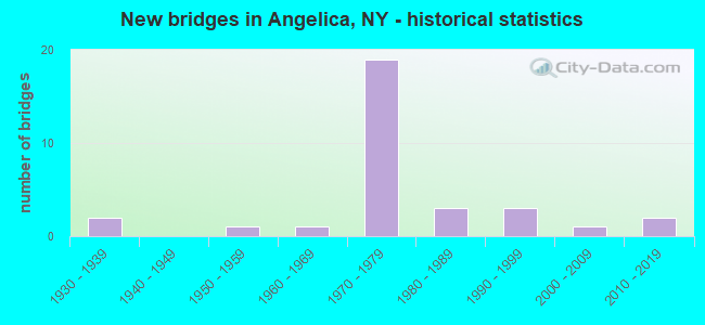
- New bridges - historical statistics
- 21930-1939
- 11950-1959
- 11960-1969
- 191970-1979
- 31980-1989
- 31990-1999
- 12000-2009
- 22010-2019

- Reconstructed bridges - Historical Statistics
- 21990-1999
- 62000-2009
- 12010-2019
- 22020-2022


- Bridge Condition - Deck
- 24.0%Excellent
- 20.0%Very good
- 20.0%Good
- 28.0%Satisfactory
- 8.0%Fair

- Bridge Condition - Superstructure
- 24.0%Excellent
- 4.0%Very good
- 44.0%Good
- 12.0%Satisfactory
- 16.0%Fair

- Bridge Condition - Substructure
- 12.0%Excellent
- 16.0%Very good
- 24.0%Good
- 32.0%Satisfactory
- 12.0%Fair
- 4.0%Poor

- Bridge Condition - Channel
- 16.7%Excellent
- 27.8%Very good
- 5.6%Good
- 33.3%Satisfactory
- 16.7%Fair
Find on map >> Show street view
Structure Number: 1061671, Location: 0.8 MI E JCT RTS 17 + 19 (Lat: 42.270858, Lng: -78.051508), Route carried "on" structure: Interstate 86, Year Built: 1973, Year Reconstructed: 2003, Status: Open, Structure Length: 2.83m (9.28ft), Average Daily Traffic: 2,907 (year 2009), Truck Traffic: 39%, Design Load: HS 20, Features Intersected: CAMP ROAD
Minimum Vertical Clearance: 30+ m (98+ ft), Kilometerpoint: 25.310, Lanes on structure: 2, Lanes under structure: 2, Base Highway Network: Yes, Owner: State Highway Agency, Approaching Roadway Width: 12.8m (42.0ft), Skew: 1 degrees, Material/Design: Steel, Design/Construction: Stringer/Multi-beam, Number Of Spans In Main Unit: 1, Length of Maximum Span: 27.4m (89.9ft), Curb-To-Curb Width: 12.5m (41.0ft), Out-to-Out Width: 13.4m (44.0ft)
Condition: Deck: Good, Superstructure: Good, Substructure: Fair, Operating Rating: 88.0 metric tons, Method Used To Determine Operating Rating: Load Factor (LF), Inventory Rating: 52.6 metric tons, Method Used To Determine Inventory Rating: Load Factor (LF), Structural Evaluation: Somewhat better than minimum adequacy, Deck Geometry: Better than present minimum criteria, Underclear: Meets minimum limits, Approach Roadway Alignment: Equal to present desirable criteria, Length Of Structure Improvement: 2.83m (9.28ft), Designated Inspection Frequency: Every 24 months, Inspection Date: June 2021, Bridge Improvement Cost: $1,478,000, Roadway Improvement Cost: $866,000, Total Project Cost: $2,343,000 ( Estimate for 2021), Deck Structure Type: Concrete Cast-file-Place, Wearing Surface/Protective System: Wearing Surface: Integral Concrete, Deck Protection: Epoxy Coated Reinforcing
Find on map >> Show street view
Structure Number: 1061672, Location: 0.8 MI E JCT RTS 17 + 19 (Lat: 42.270158, Lng: -78.050994), Route carried "on" structure: Interstate 86, Year Built: 1973, Year Reconstructed: 2003, Status: Open, Structure Length: 2.83m (9.28ft), Average Daily Traffic: 2,286 (year 2018), Truck Traffic: 36%, Average Future Daily Traffic: 4,265 (year 2040), Design Load: HS 20, Features Intersected: CAMP ROAD
Minimum Vertical Clearance: 30+ m (98+ ft), Kilometerpoint: 25.310, Lanes on structure: 2, Lanes under structure: 2, Base Highway Network: Yes, Owner: State Highway Agency, Approaching Roadway Width: 12.8m (42.0ft), Skew: 1 degrees, Material/Design: Steel, Design/Construction: Stringer/Multi-beam, Number Of Spans In Main Unit: 1, Length of Maximum Span: 27.4m (89.9ft), Curb-To-Curb Width: 12.5m (41.0ft), Out-to-Out Width: 13.4m (44.0ft)
Condition: Deck: Good, Superstructure: Good, Substructure: Satisfactory, Operating Rating: 96.2 metric tons, Method Used To Determine Operating Rating: Load Factor (LF), Inventory Rating: 57.2 metric tons, Method Used To Determine Inventory Rating: Load Factor (LF), Structural Evaluation: Equal to present minimum criteria, Deck Geometry: Better than present minimum criteria, Underclear: Meets minimum limits, Approach Roadway Alignment: Equal to present desirable criteria, Length Of Structure Improvement: 2.83m (9.28ft), Designated Inspection Frequency: Every 24 months, Inspection Date: June 2021, Bridge Improvement Cost: $1,651,000, Roadway Improvement Cost: $967,000, Total Project Cost: $2,618,000 ( Estimate for 2021), Deck Structure Type: Concrete Cast-file-Place, Wearing Surface/Protective System: Wearing Surface: Integral Concrete
Find on map >> Show street view
Structure Number: 1062201, Location: JCT RTE 17 + GENESEE R (Lat: 42.264908, Lng: -78.058600), Route carried "on" structure: Interstate 86, Year Built: 1973, Status: Open, Structure Length: 11.55m (37.89ft), Average Daily Traffic: 2,907 (year 2009), Truck Traffic: 39%, Design Load: HS 20, Features Intersected: GENESEE RIVER
Minimum Vertical Clearance: 30+ m (98+ ft), Kilometerpoint: 24.425, Lanes on structure: 2, Base Highway Network: Yes, Owner: State Highway Agency, Approaching Roadway Width: 12.8m (42.0ft), Material/Design: Steel, Design/Construction: Stringer/Multi-beam, Number Of Spans In Main Unit: 3, Length of Maximum Span: 38.1m (125.0ft), Curb-To-Curb Width: 12.5m (41.0ft), Out-to-Out Width: 13.4m (44.0ft)
Condition: Deck: Satisfactory, Superstructure: Satisfactory, Substructure: Satisfactory, Channel: Satisfactory, Operating Rating: 78.9 metric tons, Method Used To Determine Operating Rating: Load Factor (LF), Inventory Rating: 40.8 metric tons, Method Used To Determine Inventory Rating: Load Factor (LF), Structural Evaluation: Equal to present minimum criteria, Deck Geometry: Better than present minimum criteria, Waterway Adequacy: High priority of replacement, Approach Roadway Alignment: Equal to present desirable criteria, Length Of Structure Improvement: 11.55m (37.89ft), Designated Inspection Frequency: Every 24 months, Inspection Date: May 2020, Bridge Improvement Cost: $3,966,000, Roadway Improvement Cost: $2,323,000, Total Project Cost: $6,289,000 ( Estimate for 2021), Deck Structure Type: Concrete Cast-file-Place, Wearing Surface/Protective System: Wearing Surface: Epoxy Overlay
Find on map >> Show street view
Structure Number: 1062202, Location: JCT I86 + GENESEE RIVER (Lat: 42.264717, Lng: -78.058103), Route carried "on" structure: Interstate 86, Year Built: 1973, Status: Open, Structure Length: 11.55m (37.89ft), Average Daily Traffic: 2,286 (year 2018), Truck Traffic: 36%, Average Future Daily Traffic: 4,265 (year 2040), Design Load: HS 20, Features Intersected: GENESEE RIVER
Minimum Vertical Clearance: 30+ m (98+ ft), Kilometerpoint: 24.425, Lanes on structure: 2, Base Highway Network: Yes, Owner: State Highway Agency, Approaching Roadway Width: 12.8m (42.0ft), Material/Design: Steel, Design/Construction: Stringer/Multi-beam, Number Of Spans In Main Unit: 3, Length of Maximum Span: 38.1m (125.0ft), Curb-To-Curb Width: 12.5m (41.0ft), Out-to-Out Width: 13.4m (44.0ft)
Condition: Deck: Satisfactory, Superstructure: Satisfactory, Substructure: Satisfactory, Channel: Satisfactory, Inventory Rating: 60.8 metric tons, Method Used To Determine Inventory Rating: Load Factor (LF), Structural Evaluation: Equal to present minimum criteria, Deck Geometry: Better than present minimum criteria, Waterway Adequacy: Meets minimum limits, Approach Roadway Alignment: Equal to present desirable criteria, Length Of Structure Improvement: 11.55m (37.89ft), Designated Inspection Frequency: Every 24 months, Inspection Date: May 2020, Bridge Improvement Cost: $4,116,000, Roadway Improvement Cost: $2,410,000, Total Project Cost: $6,526,000 ( Estimate for 2021), Deck Structure Type: Concrete Cast-file-Place, Wearing Surface/Protective System: Wearing Surface: Integral Concrete
Find on map >> Show street view
Structure Number: 1062211, Location: 6.9 MI NE JCT RTS 17 + 19 (Lat: 42.299483, Lng: -78.025983), Route carried "on" structure: Alternate County highway , Year Built: 1973, Status: Open, Structure Length: 4.21m (13.81ft), Average Daily Traffic: 580 (year 2017), Truck Traffic: 7%, Design Load: HS 20, Features Intersected: RTE I86, Facility Carried by Structure: OLEAN ST (CR 20)
Minimum Vertical Clearance: 30+ m (98+ ft), Kilometerpoint: 0.965, Lanes on structure: 2, Lanes under structure: 2, Owner: State Highway Agency, Approaching Roadway Width: 13.1m (43.0ft), Skew: 4 degrees, Material/Design: Steel, Design/Construction: Stringer/Multi-beam, Number Of Spans In Main Unit: 1, Length of Maximum Span: 41.1m (134.8ft), Curb-To-Curb Width: 13.2m (43.3ft), Out-to-Out Width: 14.0m (45.9ft)
Condition: Deck: Fair, Superstructure: Good, Substructure: Fair, Operating Rating: 92.5 metric tons, Method Used To Determine Operating Rating: Load Factor (LF), Inventory Rating: 55.3 metric tons, Method Used To Determine Inventory Rating: Load Factor (LF), Structural Evaluation: Somewhat better than minimum adequacy, Deck Geometry: Superior to present desirable criteria, Underclear: Somewhat better than minimum adequacy, Approach Roadway Alignment: Equal to present desirable criteria, Length Of Structure Improvement: 4.20m (13.78ft), Designated Inspection Frequency: Every 24 months, Inspection Date: November 2020, Bridge Improvement Cost: $2,428,000, Roadway Improvement Cost: $1,422,000, Total Project Cost: $3,850,000 ( Estimate for 2021), Deck Structure Type: Concrete Cast-file-Place, Wearing Surface/Protective System: Wearing Surface: Bituminous, Membrane: Other
Find on map >> Show street view
Structure Number: 1062212, Location: 6.9 MI NE JCT RTS 17 + 19 (Lat: 42.298747, Lng: -78.026061), Route carried "on" structure: Alternate County highway , Year Built: 1973, Year Reconstructed: 2020, Status: Open, Structure Length: 4.21m (13.81ft), Average Daily Traffic: 580 (year 2017), Truck Traffic: 7%, Design Load: HL 93, Features Intersected: RTE I86, Facility Carried by Structure: OLEAN ST (CR 20)
Minimum Vertical Clearance: 30+ m (98+ ft), Kilometerpoint: 1.046, Lanes on structure: 2, Lanes under structure: 2, Owner: State Highway Agency, Approaching Roadway Width: 13.1m (43.0ft), Skew: 4 degrees, Material/Design: Steel, Design/Construction: Stringer/Multi-beam, Number Of Spans In Main Unit: 1, Length of Maximum Span: 41.1m (134.8ft), Curb-To-Curb Width: 13.1m (43.0ft), Out-to-Out Width: 14.0m (45.9ft)
Condition: Deck: Very good, Superstructure: Good, Substructure: Good, Inventory Rating: 60.8 metric tons, Method Used To Determine Inventory Rating: Load Factor (LF), Structural Evaluation: Better than present minimum criteria, Deck Geometry: Superior to present desirable criteria, Underclear: Somewhat better than minimum adequacy, Approach Roadway Alignment: Equal to present desirable criteria, Length Of Structure Improvement: 4.20m (13.78ft), Designated Inspection Frequency: Every 24 months, Inspection Date: November 2020, Bridge Improvement Cost: $2,480,000, Roadway Improvement Cost: $1,452,000, Total Project Cost: $3,932,000 ( Estimate for 2021), Deck Structure Type: Concrete Cast-file-Place, Wearing Surface/Protective System: Wearing Surface: Integral Concrete, Deck Protection: Epoxy Coated Reinforcing
Find on map >> Show street view
Structure Number: 1062221, Location: 7 MILES NE JCT I86 & SR19 (Lat: 42.300644, Lng: -78.012686), Route carried "on" structure: Interstate 86, Year Built: 1973, Year Reconstructed: 2008, Status: Open, Structure Length: 2.93m (9.61ft), Average Daily Traffic: 2,907 (year 2013), Truck Traffic: 39%, Design Load: HS 20+Mod, Features Intersected: PEACOCK HILL ROAD
Minimum Vertical Clearance: 30+ m (98+ ft), Kilometerpoint: 30.378, Lanes on structure: 2, Lanes under structure: 2, Base Highway Network: Yes, Owner: State Highway Agency, Approaching Roadway Width: 12.5m (41.0ft), Skew: 1 degrees, Material/Design: Steel, Design/Construction: Stringer/Multi-beam, Number Of Spans In Main Unit: 1, Length of Maximum Span: 28.0m (91.9ft), Curb-To-Curb Width: 12.5m (41.0ft), Out-to-Out Width: 13.4m (44.0ft)
Condition: Deck: Satisfactory, Superstructure: Good, Substructure: Satisfactory, Operating Rating: 39.2 metric tons, Method Used To Determine Operating Rating: Load and Resistance Factor Rating (LRFR) rating reported by rating factor(RF) method using HL-93 loadings, Inventory Rating: 30.1 metric tons, Method Used To Determine Inventory Rating: Load and Resistance Factor Rating (LRFR) rating reported by rating factor(RF) method using HL-93 loadings, Structural Evaluation: Equal to present minimum criteria, Deck Geometry: Better than present minimum criteria, Underclear: Better than present minimum criteria, Approach Roadway Alignment: Equal to present desirable criteria, Length Of Structure Improvement: 2.92m (9.58ft), Designated Inspection Frequency: Every 24 months, Inspection Date: May 2020, Bridge Improvement Cost: $1,730,000, Roadway Improvement Cost: $1,013,000, Total Project Cost: $2,743,000 ( Estimate for 2021), Deck Structure Type: Concrete Cast-file-Place, Wearing Surface/Protective System: Wearing Surface: Epoxy Overlay, Deck Protection: Epoxy Coated Reinforcing
Find on map >> Show street view
Structure Number: 1062222, Location: 7 MILES NE JCT I86 & SR19 (Lat: 42.300144, Lng: -78.012639), Route carried "on" structure: Interstate 86, Year Built: 1973, Year Reconstructed: 2008, Status: Open, Structure Length: 2.93m (9.61ft), Average Daily Traffic: 2,286 (year 2018), Truck Traffic: 38%, Average Future Daily Traffic: 4,265 (year 2040), Design Load: HS 20+Mod, Features Intersected: PEACOCK HILL ROAD
Minimum Vertical Clearance: 30+ m (98+ ft), Kilometerpoint: 30.378, Lanes on structure: 2, Lanes under structure: 2, Base Highway Network: Yes, Owner: State Highway Agency, Approaching Roadway Width: 12.5m (41.0ft), Skew: 2 degrees, Material/Design: Steel, Design/Construction: Stringer/Multi-beam, Number Of Spans In Main Unit: 1, Length of Maximum Span: 28.0m (91.9ft), Curb-To-Curb Width: 12.6m (41.3ft), Out-to-Out Width: 13.5m (44.3ft)
Condition: Deck: Satisfactory, Superstructure: Good, Substructure: Satisfactory, Operating Rating: 35.6 metric tons, Method Used To Determine Operating Rating: Load and Resistance Factor Rating (LRFR) rating reported by rating factor(RF) method using HL-93 loadings, Inventory Rating: 27.5 metric tons, Method Used To Determine Inventory Rating: Load and Resistance Factor Rating (LRFR) rating reported by rating factor(RF) method using HL-93 loadings, Structural Evaluation: Equal to present minimum criteria, Deck Geometry: Better than present minimum criteria, Underclear: Superior to present desirable criteria, Approach Roadway Alignment: Equal to present desirable criteria, Length Of Structure Improvement: 2.92m (9.58ft), Designated Inspection Frequency: Every 24 months, Inspection Date: May 2020, Bridge Improvement Cost: $1,907,000, Roadway Improvement Cost: $1,117,000, Total Project Cost: $3,024,000 ( Estimate for 2021), Deck Structure Type: Concrete Cast-file-Place, Wearing Surface/Protective System: Wearing Surface: Epoxy Overlay, Deck Protection: Epoxy Coated Reinforcing
Find on map >> Show street view
Structure Number: 106223, Location: JCT CR 2 & I86 - ANGELICA (Lat: 42.299500, Lng: -77.959497), Route carried "on" structure: Alternate County highway , Year Built: 1973, Year Reconstructed: 2020, Status: Open, Structure Length: 8.99m (29.49ft), Average Daily Traffic: 201 (year 2019), Truck Traffic: 6%, Average Future Daily Traffic: 281 (year 2039), Design Load: HL 93, Features Intersected: 86I 17 6103 2218, RTE I8, Facility Carried by Structure: CR 2 Karr Valley R
Minimum Vertical Clearance: 30+ m (98+ ft), Kilometerpoint: 2.655, Lanes on structure: 2, Lanes under structure: 4, Owner: State Highway Agency, Approaching Roadway Width: 10.4m (34.1ft), Skew: 3 degrees, Material/Design: Steel, Design/Construction: Stringer/Multi-beam, Number Of Spans In Main Unit: 2, Length of Maximum Span: 46.3m (151.9ft), Curb-To-Curb Width: 9.7m (31.8ft), Out-to-Out Width: 11.0m (36.1ft)
Condition: Deck: Very good, Superstructure: Good, Substructure: Good, Operating Rating: 75.3 metric tons, Method Used To Determine Operating Rating: Load Factor (LF), Inventory Rating: 49.9 metric tons, Method Used To Determine Inventory Rating: Load Factor (LF), Structural Evaluation: Better than present minimum criteria, Deck Geometry: Equal to present minimum criteria, Underclear: Meets minimum limits, Approach Roadway Alignment: Equal to present desirable criteria, Length Of Structure Improvement: 8.99m (29.49ft), Designated Inspection Frequency: Every 24 months, Inspection Date: December 2020, Bridge Improvement Cost: $3,064,000, Roadway Improvement Cost: $1,794,000, Total Project Cost: $4,859,000 ( Estimate for 2021), Deck Structure Type: Concrete Cast-file-Place, Wearing Surface/Protective System: Wearing Surface: Integral Concrete, Deck Protection: Epoxy Coated Reinforcing
Find on map >> Show street view
Structure Number: 221414, Location: 1.5 MI NW OF ANGELICA (Lat: 42.325242, Lng: -78.037872), Route carried "on" structure: Other road , Year Built: 2016, Status: Open, Structure Length: 2.29m (7.51ft), Average Daily Traffic: 186 (year 2018), Truck Traffic: 5%, Average Future Daily Traffic: 260 (year 2038), Design Load: HS 25 or greater, Features Intersected: BAKER CREEK, Facility Carried by Structure: PEAVY ROAD
Minimum Vertical Clearance: 30+ m (98+ ft), Kilometerpoint: 1.432, Lanes on structure: 2, Owner: Town or Township Highway Agency, Approaching Roadway Width: 6.4m (21.0ft), Skew: 1 degrees, Material/Design: Prestressed concrete, Design/Construction: Box Beam or Girders - Multiple, Number Of Spans In Main Unit: 1, Length of Maximum Span: 22.6m (74.1ft), Curb-To-Curb Width: 7.5m (24.6ft), Out-to-Out Width: 8.4m (27.6ft)
Condition: Deck: Excellent, Superstructure: Excellent, Substructure: Excellent, Channel: Excellent, Inventory Rating: 68.0 metric tons, Method Used To Determine Inventory Rating: Load Factor (LF), Structural Evaluation: Superior to present desirable criteria, Deck Geometry: Somewhat better than minimum adequacy, Waterway Adequacy: Superior to present desirable criteria, Approach Roadway Alignment: Better than present minimum criteria, Length Of Structure Improvement: 2.28m (7.48ft), Designated Inspection Frequency: Every 24 months, Underwater Inspection Frequency: Every 60 months, Inspection Date: November 2020, Underwater Inspection Date: September 2015, Bridge Improvement Cost: $545,000, Roadway Improvement Cost: $319,000, Total Project Cost: $864,000 ( Estimate for 2021), Wearing Surface/Protective System: Wearing Surface: Bituminous, Membrane: Other
Find on map >> Show street view
Structure Number: 221415, Location: 1.8 MI NW OF ANGELICA (Lat: 42.327492, Lng: -78.035250), Route carried "on" structure: Other road , Year Built: 1974, Year Reconstructed: 2008, Status: Open, Structure Length: 0.91m (2.99ft), Average Daily Traffic: 15 (year 2018), Average Future Daily Traffic: 21 (year 2038), Features Intersected: TRIB BAKER CREEK, Facility Carried by Structure: COMBS ROAD
Minimum Vertical Clearance: 30+ m (98+ ft), Kilometerpoint: 0.193, Lanes on structure: 2, Owner: Town or Township Highway Agency, Approaching Roadway Width: 5.5m (18.0ft), Material/Design: Steel, Design/Construction: Stringer/Multi-beam, Number Of Spans In Main Unit: 1, Length of Maximum Span: 8.5m (27.9ft), Curb-To-Curb Width: 7.5m (24.6ft), Out-to-Out Width: 7.9m (25.9ft)
Condition: Deck: Very good, Superstructure: Fair, Substructure: Satisfactory, Channel: Satisfactory, Operating Rating: 24.3 metric tons, Method Used To Determine Operating Rating: Load and Resistance Factor Rating (LRFR) rating reported by rating factor(RF) method using HL-93 loadings, Inventory Rating: 18.8 metric tons, Method Used To Determine Inventory Rating: Load and Resistance Factor Rating (LRFR) rating reported by rating factor(RF) method using HL-93 loadings, Structural Evaluation: Somewhat better than minimum adequacy, Deck Geometry: Equal to present minimum criteria, Waterway Adequacy: Meets minimum limits, Approach Roadway Alignment: Equal to present minimum criteria, Length Of Structure Improvement: 0.91m (2.99ft), Designated Inspection Frequency: Every 24 months, Inspection Date: May 2020, Bridge Improvement Cost: $362,000, Roadway Improvement Cost: $212,000, Total Project Cost: $574,000 ( Estimate for 2021), Deck Structure Type: Wood or Timber, Wearing Surface/Protective System: Wearing Surface: Bituminous
Find on map >> Show street view
Structure Number: 221418, Location: 0.8MI NE OF ANGELICA (Lat: 42.315633, Lng: -78.001008), Route carried "on" structure: Other road , Year Built: 1999, Status: Open, Structure Length: 0.88m (2.89ft), Average Daily Traffic: 85 (year 2018), Truck Traffic: 2%, Average Future Daily Traffic: 119 (year 2038), Design Load: HS 25 or greater, Features Intersected: COMMONS CREEK, Facility Carried by Structure: COMMONS ROAD
Minimum Vertical Clearance: 30+ m (98+ ft), Kilometerpoint: 0.306, Lanes on structure: 2, Owner: Town or Township Highway Agency, Approaching Roadway Width: 6.1m (20.0ft), Skew: 2 degrees, Material/Design: Wood or Timber, Design/Construction: Slab, Number Of Spans In Main Unit: 1, Length of Maximum Span: 8.2m (26.9ft), Curb-To-Curb Width: 7.2m (23.6ft), Out-to-Out Width: 7.9m (25.9ft)
Condition: Deck: Good, Superstructure: Good, Substructure: Good, Channel: Satisfactory, Operating Rating: 89.8 metric tons, Method Used To Determine Operating Rating: Load Factor (LF), Inventory Rating: 75.3 metric tons, Method Used To Determine Inventory Rating: Load Factor (LF), Structural Evaluation: Better than present minimum criteria, Deck Geometry: Somewhat better than minimum adequacy, Waterway Adequacy: Somewhat better than minimum adequacy, Approach Roadway Alignment: Equal to present desirable criteria, Length Of Structure Improvement: 0.88m (2.89ft), Designated Inspection Frequency: Every 24 months, Inspection Date: May 2021, Bridge Improvement Cost: $647,000, Roadway Improvement Cost: $379,000, Total Project Cost: $1,026,000 ( Estimate for 2021), Wearing Surface/Protective System: Wearing Surface: Bituminous, Membrane: Other
Find on map >> Show street view
Structure Number: 221534, Location: IN ANGELICA (Lat: 42.303111, Lng: -78.011825), Route carried "on" structure: Other road , Year Built: 1970, Status: Open, Structure Length: 5.70m (18.70ft), Average Daily Traffic: 1,220 (year 2018), Truck Traffic: 5%, Average Future Daily Traffic: 1,708 (year 2038), Design Load: HS 20, Features Intersected: ANGELICA CREEK, Facility Carried by Structure: PEACOCK HILL ROAD
Minimum Vertical Clearance: 30+ m (98+ ft), Kilometerpoint: 0.853, Lanes on structure: 2, Owner: Town or Township Highway Agency, Approaching Roadway Width: 12.2m (40.0ft), Skew: 4 degrees, Material/Design: Steel, Design/Construction: Stringer/Multi-beam, Number Of Spans In Main Unit: 2, Length of Maximum Span: 27.4m (89.9ft), Curb or Sidewalk Widths: Left: 0.0m, Right: 1.5m (4.9ft), Curb-To-Curb Width: 12.2m (40.0ft), Out-to-Out Width: 14.5m (47.6ft)
Condition: Deck: Satisfactory, Superstructure: Fair, Substructure: Fair, Channel: Satisfactory, Operating Rating: 64.4 metric tons, Method Used To Determine Operating Rating: Load Factor (LF), Inventory Rating: 38.1 metric tons, Method Used To Determine Inventory Rating: Load Factor (LF), Structural Evaluation: Somewhat better than minimum adequacy, Deck Geometry: Better than present minimum criteria, Waterway Adequacy: Equal to present desirable criteria, Approach Roadway Alignment: Equal to present desirable criteria, Length Of Structure Improvement: 5.73m (18.80ft), Designated Inspection Frequency: Every 24 months, Underwater Inspection Frequency: Every 60 months, Inspection Date: April 2021, Underwater Inspection Date: September 2020, Bridge Improvement Cost: $2,329,000, Roadway Improvement Cost: $1,364,000, Total Project Cost: $3,693,000 ( Estimate for 2021), Deck Structure Type: Concrete Cast-file-Place, Wearing Surface/Protective System: Wearing Surface: Bituminous
Find on map >> Show street view
Structure Number: 221536, Location: IN ANGELICA (Lat: 42.305297, Lng: -78.020650), Route carried "on" structure: Other road , Year Built: 1973, Status: Open, Structure Length: 3.44m (11.29ft), Average Daily Traffic: 170 (year 2018), Truck Traffic: 2%, Average Future Daily Traffic: 238 (year 2038), Features Intersected: ANGELICA CREEK, Facility Carried by Structure: CENTER STREET
Minimum Vertical Clearance: 30+ m (98+ ft), Kilometerpoint: 0.209, Lanes on structure: 2, Owner: Town or Township Highway Agency, Approaching Roadway Width: 6.1m (20.0ft), Skew: 2 degrees, Material/Design: Steel, Design/Construction: Stringer/Multi-beam, Number Of Spans In Main Unit: 1, Length of Maximum Span: 34.1m (111.9ft), Curb or Sidewalk Widths: Left: 1.6m (5.2ft), Right: 0.0m, Curb-To-Curb Width: 7.3m (24.0ft), Out-to-Out Width: 9.8m (32.2ft)
Condition: Deck: Fair, Superstructure: Good, Substructure: Satisfactory, Channel: Very good, Operating Rating: 58.0 metric tons, Method Used To Determine Operating Rating: Load and Resistance Factor Rating (LRFR) rating reported by rating factor(RF) method using HL-93 loadings, Inventory Rating: 44.7 metric tons, Method Used To Determine Inventory Rating: Load and Resistance Factor Rating (LRFR) rating reported by rating factor(RF) method using HL-93 loadings, Structural Evaluation: Equal to present minimum criteria, Deck Geometry: Somewhat better than minimum adequacy, Waterway Adequacy: Equal to present desirable criteria, Approach Roadway Alignment: Somewhat better than minimum adequacy, Length Of Structure Improvement: 3.44m (11.29ft), Designated Inspection Frequency: Every 24 months, Inspection Date: April 2020, Bridge Improvement Cost: $1,154,000, Roadway Improvement Cost: $676,000, Total Project Cost: $1,829,000 ( Estimate for 2021), Deck Structure Type: Concrete Cast-file-Place, Wearing Surface/Protective System: Wearing Surface: Bituminous
Find on map >> Show street view
Structure Number: 225602, Location: WITHIN VILL. OF ANGELICA (Lat: 42.303936, Lng: -78.008144), Route carried "on" structure: Other road , Year Built: 1985, Status: Open, Structure Length: 0.98m (3.22ft), Average Daily Traffic: 1,070 (year 2017), Truck Traffic: 6%, Average Future Daily Traffic: 1,116 (year 2040), Features Intersected: COMMONS CREEK, Facility Carried by Structure: EAST MAIN STREET
Minimum Vertical Clearance: 30+ m (98+ ft), Kilometerpoint: 0.628, Lanes on structure: 2, Owner: Town or Township Highway Agency, Approaching Roadway Width: 9.1m (29.9ft), Material/Design: Wood or Timber, Design/Construction: Slab, Number Of Spans In Main Unit: 1, Length of Maximum Span: 9.4m (30.8ft), Curb-To-Curb Width: 10.2m (33.5ft), Out-to-Out Width: 10.8m (35.4ft)
Condition: Deck: Very good, Superstructure: Very good, Substructure: Very good, Channel: Good, Operating Rating: 35.4 metric tons, Method Used To Determine Operating Rating: Load Factor (LF), Inventory Rating: 25.4 metric tons, Method Used To Determine Inventory Rating: Load Factor (LF), Structural Evaluation: Equal to present minimum criteria, Deck Geometry: Somewhat better than minimum adequacy, Waterway Adequacy: Equal to present minimum criteria, Approach Roadway Alignment: Equal to present desirable criteria, Length Of Structure Improvement: 0.97m (3.18ft), Designated Inspection Frequency: Every 24 months, Inspection Date: June 2020, Bridge Improvement Cost: $419,000, Roadway Improvement Cost: $245,000, Total Project Cost: $665,000 ( Estimate for 2021), Wearing Surface/Protective System: Wearing Surface: Bituminous
Find on map >> Show street view
Structure Number: 232999, Location: ON OLEAN ST. IN ANGELICA (Lat: 42.306283, Lng: -78.023239), Route carried "on" structure: County highway , Year Built: 1986, Status: Open, Structure Length: 3.32m (10.89ft), Average Daily Traffic: 1,084 (year 2018), Truck Traffic: 5%, Average Future Daily Traffic: 1,518 (year 2038), Design Load: HS 20, Features Intersected: ANGELICA CREEK, Facility Carried by Structure: OLEAN STREET
Minimum Vertical Clearance: 30+ m (98+ ft), Kilometerpoint: 0.177, Lanes on structure: 2, Owner: Town or Township Highway Agency, Approaching Roadway Width: 7.3m (24.0ft), Skew: 1 degrees, Material/Design: Prestressed concrete, Design/Construction: Box Beam or Girders - Multiple, Number Of Spans In Main Unit: 1, Length of Maximum Span: 31.6m (103.7ft), Curb or Sidewalk Widths: Left: 1.7m (5.6ft), Right: 1.7m (5.6ft), Curb-To-Curb Width: 7.3m (24.0ft), Out-to-Out Width: 11.3m (37.1ft)
Condition: Deck: Good, Superstructure: Good, Substructure: Very good, Channel: Very good, Operating Rating: 64.8 metric tons, Method Used To Determine Operating Rating: Load and Resistance Factor Rating (LRFR) rating reported by rating factor(RF) method using HL-93 loadings, Inventory Rating: 26.6 metric tons, Method Used To Determine Inventory Rating: Load and Resistance Factor Rating (LRFR) rating reported by rating factor(RF) method using HL-93 loadings, Structural Evaluation: Equal to present minimum criteria, Deck Geometry: Meets minimum limits, Waterway Adequacy: Equal to present desirable criteria, Approach Roadway Alignment: Equal to present desirable criteria, Length Of Structure Improvement: 3.32m (10.89ft), Designated Inspection Frequency: Every 24 months, Inspection Date: April 2020, Bridge Improvement Cost: $1,055,000, Roadway Improvement Cost: $618,000, Total Project Cost: $1,672,000 ( Estimate for 2021), Deck Structure Type: Concrete Cast-file-Place, Wearing Surface/Protective System: Wearing Surface: Bituminous, Membrane: Other, Deck Protection: Epoxy Coated Reinforcing
Find on map >> Show street view
Structure Number: 304779, Location: 1.4 MI W OF ANGELICA (Lat: 42.308572, Lng: -78.042889), Route carried "on" structure: Alternate County highway , Year Built: 1939, Year Reconstructed: 2008, Status: Open, Structure Length: 2.53m (8.30ft), Average Daily Traffic: 753 (year 2018), Truck Traffic: 9%, Average Future Daily Traffic: 785 (year 2040), Design Load: HS 25 or greater, Features Intersected: BAKER CREEK, Facility Carried by Structure: COUNTY ROAD 16
Minimum Vertical Clearance: 30+ m (98+ ft), Kilometerpoint: 3.170, Lanes on structure: 2, Owner: County Highway Agency, Approaching Roadway Width: 7.6m (24.9ft), Material/Design: Steel, Design/Construction: Stringer/Multi-beam, Number Of Spans In Main Unit: 1, Length of Maximum Span: 23.7m (77.8ft), Curb-To-Curb Width: 9.0m (29.5ft), Out-to-Out Width: 10.0m (32.8ft)
Condition: Deck: Excellent, Superstructure: Excellent, Substructure: Very good, Channel: Excellent, Operating Rating: 89.8 metric tons, Method Used To Determine Operating Rating: Load Factor (LF), Inventory Rating: 52.6 metric tons, Method Used To Determine Inventory Rating: Load Factor (LF), Structural Evaluation: Equal to present desirable criteria, Deck Geometry: Somewhat better than minimum adequacy, Waterway Adequacy: Superior to present desirable criteria, Approach Roadway Alignment: Equal to present minimum criteria, Length Of Structure Improvement: 2.52m (8.27ft), Designated Inspection Frequency: Every 24 months, Inspection Date: August 2020, Bridge Improvement Cost: $1,017,000, Roadway Improvement Cost: $596,000, Total Project Cost: $1,613,000 ( Estimate for 2021), Deck Structure Type: Concrete Cast-file-Place, Wearing Surface/Protective System: Wearing Surface: Integral Concrete, Deck Protection: Galvanized Reinforcing
Find on map >> Show street view
Structure Number: 30478, Location: 1.1 MI W OF ANGELICA (Lat: 42.310469, Lng: -78.037467), Route carried "on" structure: County highway , Year Built: 1939, Year Reconstructed: 2008, Status: Open, Structure Length: 3.23m (10.60ft), Average Daily Traffic: 753 (year 2018), Truck Traffic: 9%, Average Future Daily Traffic: 785 (year 2040), Design Load: HS 25 or greater, Features Intersected: ANGELICA CREEK, Facility Carried by Structure: COUNTY ROAD 16
Minimum Vertical Clearance: 30+ m (98+ ft), Kilometerpoint: 3.652, Lanes on structure: 2, Owner: County Highway Agency, Approaching Roadway Width: 7.6m (24.9ft), Material/Design: Steel, Design/Construction: Stringer/Multi-beam, Number Of Spans In Main Unit: 1, Length of Maximum Span: 31.1m (102.0ft), Curb-To-Curb Width: 9.0m (29.5ft), Out-to-Out Width: 10.0m (32.8ft)
Condition: Deck: Excellent, Superstructure: Excellent, Substructure: Very good, Channel: Very good, Operating Rating: 85.3 metric tons, Method Used To Determine Operating Rating: Load Factor (LF), Inventory Rating: 52.6 metric tons, Method Used To Determine Inventory Rating: Load Factor (LF), Structural Evaluation: Equal to present desirable criteria, Deck Geometry: Somewhat better than minimum adequacy, Waterway Adequacy: Superior to present desirable criteria, Approach Roadway Alignment: Better than present minimum criteria, Length Of Structure Improvement: 3.23m (10.60ft), Designated Inspection Frequency: Every 24 months, Inspection Date: August 2020, Bridge Improvement Cost: $1,204,000, Roadway Improvement Cost: $705,000, Total Project Cost: $1,909,000 ( Estimate for 2021), Deck Structure Type: Concrete Cast-file-Place, Wearing Surface/Protective System: Wearing Surface: Integral Concrete, Deck Protection: Galvanized Reinforcing
Find on map >> Show street view
Structure Number: 304781, Location: .8 MILE WEST OF ANGELICA (Lat: 42.311733, Lng: -78.031142), Route carried "on" structure: County highway , Year Built: 2003, Status: Open, Structure Length: 8.35m (27.40ft), Average Daily Traffic: 902 (year 2020), Truck Traffic: 11%, Average Future Daily Traffic: 940 (year 2040), Design Load: HS 25 or greater, Features Intersected: ANGELICA CREEK, Facility Carried by Structure: COUNTY ROAD 16
Minimum Vertical Clearance: 30+ m (98+ ft), Kilometerpoint: 4.216, Lanes on structure: 2, Owner: Town or Township Highway Agency, Maintenance Responsibility: County Highway Agency, Approaching Roadway Width: 9.1m (29.9ft), Material/Design: Wood or Timber, Design/Construction: Arch - Deck, Number Of Spans In Main Unit: 3, Length of Maximum Span: 47.8m (156.8ft), Curb-To-Curb Width: 9.3m (30.5ft), Out-to-Out Width: 9.8m (32.2ft)
Condition: Deck: Excellent, Superstructure: Excellent, Substructure: Good, Channel: Very good, Operating Rating: 54.4 metric tons, Method Used To Determine Operating Rating: Allowable Stress (AS), Inventory Rating: 40.8 metric tons, Method Used To Determine Inventory Rating: Allowable Stress (AS), Structural Evaluation: Better than present minimum criteria, Deck Geometry: Equal to present minimum criteria, Waterway Adequacy: Superior to present desirable criteria, Approach Roadway Alignment: Better than present minimum criteria, Length Of Structure Improvement: 8.35m (27.40ft), Designated Inspection Frequency: Every 24 months, Inspection Date: June 2021, Bridge Improvement Cost: $4,339,000, Roadway Improvement Cost: $2,541,000, Total Project Cost: $6,880,000 ( Estimate for 2021), Deck Structure Type: Wood or Timber, Wearing Surface/Protective System: Wearing Surface: Bituminous, Membrane: Other
Find on map >> Show street view
Structure Number: 304969, Location: 2.6 MI NORTH OF ANGELICA (Lat: 42.342911, Lng: -78.017081), Route carried "on" structure: County highway , Year Built: 1998, Status: Open, Structure Length: 0.91m (2.99ft), Average Daily Traffic: 759 (year 2018), Truck Traffic: 8%, Average Future Daily Traffic: 791 (year 2040), Design Load: HS 25 or greater, Features Intersected: N BR BAKER CREEK, Facility Carried by Structure: COUNTY ROAD 15
Minimum Vertical Clearance: 30+ m (98+ ft), Kilometerpoint: 4.409, Lanes on structure: 2, Owner: County Highway Agency, Approaching Roadway Width: 7.3m (24.0ft), Material/Design: Wood or Timber, Design/Construction: Slab, Number Of Spans In Main Unit: 1, Length of Maximum Span: 8.5m (27.9ft), Curb-To-Curb Width: 9.0m (29.5ft), Out-to-Out Width: 9.8m (32.2ft)
Condition: Deck: Satisfactory, Superstructure: Fair, Substructure: Good, Channel: Fair, Operating Rating: 78.7 metric tons, Method Used To Determine Operating Rating: Field evaluation and documented engineering judgment, Inventory Rating: 40.8 metric tons, Method Used To Determine Inventory Rating: Field evaluation and documented engineering judgment, Structural Evaluation: Somewhat better than minimum adequacy, Deck Geometry: Somewhat better than minimum adequacy, Waterway Adequacy: Equal to present minimum criteria, Approach Roadway Alignment: Better than present minimum criteria, Length Of Structure Improvement: 0.91m (2.99ft), Designated Inspection Frequency: Every 24 months, Inspection Date: March 2021, Bridge Improvement Cost: $437,000, Roadway Improvement Cost: $256,000, Total Project Cost: $692,000 ( Estimate for 2021), Wearing Surface/Protective System: Wearing Surface: Bituminous, Membrane: Other
Find on map >> Show street view
Structure Number: 332997, Location: 1.5 MI E OF ANGELICA (Lat: 42.301069, Lng: -77.987544), Route carried "on" structure: County highway , Year Built: 1991, Status: Open, Structure Length: 3.17m (10.40ft), Average Daily Traffic: 201 (year 2019), Truck Traffic: 6%, Average Future Daily Traffic: 281 (year 2039), Design Load: HS 20, Features Intersected: ANGELICA CREEK, Facility Carried by Structure: COUNTY ROAD 2
Minimum Vertical Clearance: 30+ m (98+ ft), Kilometerpoint: 0.113, Lanes on structure: 2, Owner: County Highway Agency, Approaching Roadway Width: 9.4m (30.8ft), Skew: 2 degrees, Material/Design: Prestressed concrete, Design/Construction: Box Beam or Girders - Multiple, Number Of Spans In Main Unit: 1, Length of Maximum Span: 31.0m (101.7ft), Curb-To-Curb Width: 9.4m (30.8ft), Out-to-Out Width: 10.1m (33.1ft)
Condition: Deck: Good, Superstructure: Good, Substructure: Good, Channel: Satisfactory, Operating Rating: 82.6 metric tons, Method Used To Determine Operating Rating: Load and Resistance Factor Rating (LRFR) rating reported by rating factor(RF) method using HL-93 loadings, Inventory Rating: 48.6 metric tons, Method Used To Determine Inventory Rating: Load and Resistance Factor Rating (LRFR) rating reported by rating factor(RF) method using HL-93 loadings, Structural Evaluation: Better than present minimum criteria, Deck Geometry: Equal to present minimum criteria, Waterway Adequacy: Equal to present desirable criteria, Approach Roadway Alignment: Equal to present desirable criteria, Length Of Structure Improvement: 3.16m (10.37ft), Designated Inspection Frequency: Every 24 months, Inspection Date: March 2020, Bridge Improvement Cost: $1,341,000, Roadway Improvement Cost: $785,000, Total Project Cost: $2,127,000 ( Estimate for 2021), Deck Structure Type: Concrete Cast-file-Place, Wearing Surface/Protective System: Wearing Surface: Bituminous, Deck Protection: Epoxy Coated Reinforcing
Find on map >> Show street view
Structure Number: 332998, Location: 2.3 MI SW OF ANGELICA (Lat: 42.295519, Lng: -78.057450), Route carried "on" structure: County highway , Year Built: 2017, Status: Open, Structure Length: 4.02m (13.19ft), Average Daily Traffic: 234 (year 2018), Truck Traffic: 5%, Average Future Daily Traffic: 328 (year 2038), Design Load: HL 93, Features Intersected: ANGELICA CREEK, Facility Carried by Structure: COUNTY ROAD 43
Minimum Vertical Clearance: 32.69m (107.25ft), Kilometerpoint: 3.121, Lanes on structure: 2, Owner: County Highway Agency, Approaching Roadway Width: 9.1m (29.9ft), Material/Design: Steel, Design/Construction: Stringer/Multi-beam, Number Of Spans In Main Unit: 1, Length of Maximum Span: 39.6m (129.9ft), Curb-To-Curb Width: 9.1m (29.9ft), Out-to-Out Width: 10.1m (33.1ft)
Condition: Deck: Excellent, Superstructure: Excellent, Substructure: Excellent, Channel: Excellent, Inventory Rating: 64.4 metric tons, Method Used To Determine Inventory Rating: Load Factor (LF), Structural Evaluation: Superior to present desirable criteria, Deck Geometry: Equal to present minimum criteria, Waterway Adequacy: Superior to present desirable criteria, Approach Roadway Alignment: Equal to present minimum criteria, Length Of Structure Improvement: 4.02m (13.19ft), Designated Inspection Frequency: Every 24 months, Inspection Date: November 2021, Bridge Improvement Cost: $1,068,000, Roadway Improvement Cost: $625,000, Total Project Cost: $1,693,000 ( Estimate for 2021), Deck Structure Type: Concrete Cast-file-Place, Wearing Surface/Protective System: Wearing Surface: Integral Concrete, Deck Protection: Epoxy Coated Reinforcing
Find on map >> Show street view
Structure Number: 333, Location: 2.3 MI E OF ANGELICA (Lat: 42.298631, Lng: -77.978083), Route carried "on" structure: County highway , Year Built: 1963, Year Reconstructed: 2011, Status: Open, Structure Length: 0.91m (2.99ft), Average Daily Traffic: 201 (year 2019), Truck Traffic: 6%, Average Future Daily Traffic: 281 (year 2039), Design Load: HS 25 or greater, Features Intersected: TRIB ANGELICA CRK, Facility Carried by Structure: COUNTY ROAD 2
Minimum Vertical Clearance: 30+ m (98+ ft), Kilometerpoint: 1.030, Lanes on structure: 2, Owner: County Highway Agency, Approaching Roadway Width: 6.1m (20.0ft), Skew: 1 degrees, Material/Design: Prestressed concrete, Design/Construction: Box Beam or Girders - Multiple, Number Of Spans In Main Unit: 1, Length of Maximum Span: 8.2m (26.9ft), Curb-To-Curb Width: 9.7m (31.8ft), Out-to-Out Width: 9.8m (32.2ft)
Condition: Deck: Excellent, Superstructure: Excellent, Substructure: Excellent, Channel: Very good, Operating Rating: 77.1 metric tons, Method Used To Determine Operating Rating: Load Factor (LF), Inventory Rating: 46.3 metric tons, Method Used To Determine Inventory Rating: Load Factor (LF), Structural Evaluation: Superior to present desirable criteria, Deck Geometry: Equal to present minimum criteria, Waterway Adequacy: Equal to present minimum criteria, Approach Roadway Alignment: Equal to present desirable criteria, Length Of Structure Improvement: 0.91m (2.99ft), Designated Inspection Frequency: Every 24 months, Inspection Date: June 2021, Bridge Improvement Cost: $542,000, Roadway Improvement Cost: $317,000, Total Project Cost: $859,000 ( Estimate for 2021), Wearing Surface/Protective System: Wearing Surface: Bituminous
Find on map >> Show street view
Structure Number: 33576, Location: 2.7 MI NW OF BELMONT (Lat: 42.264078, Lng: -78.052078), Route carried "on" structure: County highway , Year Built: 1959, Year Reconstructed: 2015, Status: Open, Structure Length: 8.53m (27.99ft), Average Daily Traffic: 586 (year 2019), Truck Traffic: 13%, Average Future Daily Traffic: 820 (year 2039), Design Load: HS 20+Mod, Features Intersected: GENESEE RIVER, Facility Carried by Structure: COUNTY ROAD 20
Minimum Vertical Clearance: 30+ m (98+ ft), Kilometerpoint: 21.464, Lanes on structure: 2, Owner: County Highway Agency, Approaching Roadway Width: 6.1m (20.0ft), Material/Design: Steel, Design/Construction: Stringer/Multi-beam, Number Of Spans In Main Unit: 3, Length of Maximum Span: 28.0m (91.9ft), Curb-To-Curb Width: 9.1m (29.9ft), Out-to-Out Width: 9.8m (32.2ft)
Condition: Deck: Very good, Superstructure: Satisfactory, Substructure: Satisfactory, Channel: Fair, Inventory Rating: 62.6 metric tons, Method Used To Determine Inventory Rating: Load Factor (LF), Structural Evaluation: Equal to present minimum criteria, Deck Geometry: Equal to present minimum criteria, Waterway Adequacy: Better than present minimum criteria, Approach Roadway Alignment: Equal to present minimum criteria, Length Of Structure Improvement: 8.53m (27.99ft), Designated Inspection Frequency: Every 24 months, Underwater Inspection Frequency: Every 60 months, Inspection Date: June 2021, Underwater Inspection Date: October 2021, Bridge Improvement Cost: $2,026,000, Roadway Improvement Cost: $1,186,000, Total Project Cost: $3,212,000 ( Estimate for 2021), Deck Structure Type: Concrete Cast-file-Place, Wearing Surface/Protective System: Wearing Surface: Integral Concrete, Deck Protection: Epoxy Coated Reinforcing
Find on map >> Show street view
Structure Number: 335761, Location: 2.3 MI SW OF ANGELICA (Lat: 42.288817, Lng: -78.052731), Route carried "on" structure: County highway , Year Built: 1982, Status: Open, Structure Length: 0.70m (2.30ft), Average Daily Traffic: 234 (year 2018), Truck Traffic: 5%, Average Future Daily Traffic: 328 (year 2038), Design Load: HS 20, Features Intersected: TRIB ANGELICA CRK, Facility Carried by Structure: COUNTY ROAD 43
Minimum Vertical Clearance: 30+ m (98+ ft), Kilometerpoint: 2.237, Lanes on structure: 2, Owner: County Highway Agency, Approaching Roadway Width: 6.4m (21.0ft), Material/Design: Wood or Timber, Design/Construction: Slab, Number Of Spans In Main Unit: 1, Length of Maximum Span: 6.0m (19.7ft), Curb-To-Curb Width: 8.7m (28.5ft), Out-to-Out Width: 9.0m (29.5ft)
Condition: Deck: Satisfactory, Superstructure: Fair, Substructure: Poor, Channel: Fair, Operating Rating: 46.3 metric tons, Method Used To Determine Operating Rating: Load Factor (LF), Inventory Rating: 32.7 metric tons, Method Used To Determine Inventory Rating: Load Factor (LF), Structural Evaluation: Meets minimum limits, Deck Geometry: Equal to present minimum criteria, Waterway Adequacy: Better than present minimum criteria, Approach Roadway Alignment: Meets minimum limits, Length Of Structure Improvement: 0.70m (2.30ft), Designated Inspection Frequency: Every 24 months, Inspection Date: August 2020, Bridge Improvement Cost: $190,000, Roadway Improvement Cost: $111,000, Total Project Cost: $302,000 ( Estimate for 2021), Deck Structure Type: Wood or Timber, Wearing Surface/Protective System: Wearing Surface: Bituminous, Membrane: Other
Find on map >> Show street view
Structure Number: 1061671, Location: 0.8 MI E JCT RTS 17 + 19 (Lat: 42.270858, Lng: -78.051508), Route carried "under" structure: Bypass Other road , Year Built: 1973, Structure Length: 0. m, Average Daily Traffic: 117 (year 2018), Truck Traffic: 5%, Features Intersected: CAMP ROAD, Facility Carried by Structure: RTE I86
Minimum Vertical Clearance: 4.65m (15.26ft), Kilometerpoint: 0.064, Lanes on structure: 2, Lanes under structure: 2, Material/Design: Steel, Design/Construction: Stringer/Multi-beam, Length of Maximum Span: 27.4m (89.9ft)
Find on map >> Show street view
Structure Number: 1061672, Location: 0.8 MI E JCT RTS 17 + 19 (Lat: 42.270158, Lng: -78.050994), Route carried "under" structure: Bypass Other road , Year Built: 1973, Structure Length: 0. m, Average Daily Traffic: 117 (year 2018), Truck Traffic: 5%, Features Intersected: CAMP ROAD, Facility Carried by Structure: RTE I86
Minimum Vertical Clearance: 6.22m (20.41ft), Kilometerpoint: 0.000, Lanes on structure: 2, Lanes under structure: 2, Material/Design: Steel, Design/Construction: Stringer/Multi-beam, Length of Maximum Span: 27.4m (89.9ft)
Find on map >> Show street view
Structure Number: 1062211, Location: 6.9 MI NE JCT RTS 17 + 19 (Lat: 42.299483, Lng: -78.025983), Route carried "under" structure: Interstate 86, Year Built: 1973, Structure Length: 0. m, Average Daily Traffic: 6,116 (year 2000), Features Intersected: RTE I86, Facility Carried by Structure: OLEAN ST (CR 20)
Minimum Vertical Clearance: 5.74m (18.83ft), Kilometerpoint: 29.187, Lanes on structure: 2, Lanes under structure: 2, Material/Design: Steel, Design/Construction: Stringer/Multi-beam, Length of Maximum Span: 41.1m (134.8ft)
Find on map >> Show street view
Structure Number: 1062212, Location: 6.9 MI NE JCT RTS 17 + 19 (Lat: 42.298747, Lng: -78.026061), Route carried "under" structure: Interstate 86, Year Built: 1973, Structure Length: 0. m, Average Daily Traffic: 6,116 (year 2000), Features Intersected: RTE I86, Facility Carried by Structure: OLEAN ST (CR 20)
Minimum Vertical Clearance: 5.82m (19.09ft), Kilometerpoint: 29.187, Lanes on structure: 2, Lanes under structure: 2, Material/Design: Steel, Design/Construction: Stringer/Multi-beam, Length of Maximum Span: 41.1m (134.8ft)
Find on map >> Show street view
Structure Number: 1062221, Location: 7 MILES NE JCT I86 & SR19 (Lat: 42.300644, Lng: -78.012686), Route carried "under" structure: Other road , Year Built: 1973, Structure Length: 0. m, Average Daily Traffic: 610 (year 2018), Truck Traffic: 5%, Features Intersected: PEACOCK HILL ROAD, Facility Carried by Structure: RTE I86
Minimum Vertical Clearance: 5.36m (17.59ft), Kilometerpoint: 0.547, Lanes on structure: 2, Lanes under structure: 2, Material/Design: Steel, Design/Construction: Stringer/Multi-beam, Length of Maximum Span: 28.0m (91.9ft)
Find on map >> Show street view
Structure Number: 1062222, Location: 7 MILES NE JCT I86 & SR19 (Lat: 42.300144, Lng: -78.012639), Route carried "under" structure: Other road , Year Built: 1973, Structure Length: 0. m, Average Daily Traffic: 610 (year 2018), Truck Traffic: 5%, Features Intersected: PEACOCK HILL ROAD, Facility Carried by Structure: RTE I86
Minimum Vertical Clearance: 5.64m (18.50ft), Kilometerpoint: 0.579, Lanes on structure: 2, Lanes under structure: 2, Material/Design: Steel, Design/Construction: Stringer/Multi-beam, Length of Maximum Span: 28.0m (91.9ft)
Find on map >> Show street view
Structure Number: 106223, Location: JCT CR 2 & I86 - ANGELICA (Lat: 42.299500, Lng: -77.959497), Route carried "under" structure: Interstate 86, Year Built: 1973, Structure Length: 0. m, Average Daily Traffic: 28,252 (year 1999), Features Intersected: 86I 17 6103 2218, RTE I8, Facility Carried by Structure: CR 2 Karr Valley R
Minimum Vertical Clearance: 5.64m (18.50ft), Kilometerpoint: 35.124, Lanes on structure: 2, Lanes under structure: 2, Material/Design: Steel, Design/Construction: Stringer/Multi-beam, Length of Maximum Span: 46.3m (151.9ft)