Bridge Statistics for Angie, Louisiana (LA)
Condition, Traffic, Stress, Structural Evaluation, Project Costs
- National Bridge Inventory (NBI) Statistics
- 12Number of bridges
- 115ft / 35.5mTotal length
- $268,000Total costs
- 26,440Total average daily traffic
- 2,438Total average daily truck traffic
- 40,830Total future (year 2036) average daily traffic
- National Bridge Inventory (NBI) Registered Bridges for Angie
- No street view available for this location
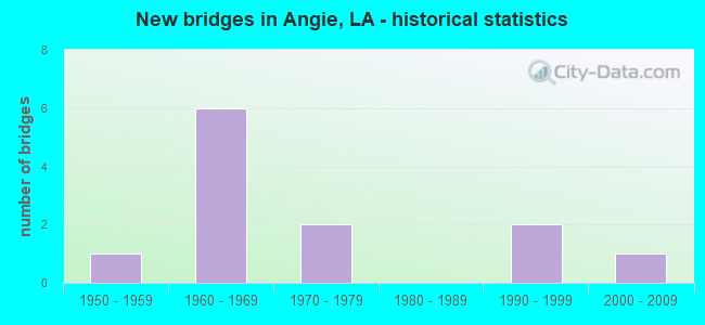
- New bridges - historical statistics
- 11950-1959
- 61960-1969
- 21970-1979
- 21990-1999
- 12000-2009


- Bridge Condition - Deck
- 20.0%Good
- 70.0%Satisfactory
- 10.0%Fair

- Bridge Condition - Superstructure
- 20.0%Good
- 70.0%Satisfactory
- 10.0%Poor

- Bridge Condition - Substructure
- 50.0%Good
- 40.0%Satisfactory
- 10.0%Fair

- Bridge Condition - Channel
- 75.0%Good
- 16.7%Satisfactory
- 8.3%Fair
Find on map >> Show street view
Structure Number: 625900300411081, Location: 1.7 M SW OF LA 438 (Lat: 30.939600, Lng: -89.827300), Route carried "on" structure: State highway 21, Year Built: 1960, Status: Open, Structure Length: 1.83m (6.00ft), Average Daily Traffic: 4,200 (year 2016), Truck Traffic: 11%, Average Future Daily Traffic: 7,140 (year 2036), Design Load: HS 20, Features Intersected: SCARBOROUGHS CREEK
Minimum Vertical Clearance: 30+ m (98+ ft), Kilometerpoint: 17.531, Lanes on structure: 2, Base Highway Network: Yes (Inventory Route: 30-04-1, Subroute: 10), Owner: State Highway Agency, Approaching Roadway Width: 12.2m (40.0ft), Material/Design: Concrete, Design/Construction: Slab, Number Of Spans In Main Unit: 3, Length of Maximum Span: 6.1m (20.0ft), Curb-To-Curb Width: 8.5m (27.9ft), Out-to-Out Width: 10.2m (33.5ft)
Condition: Deck: Satisfactory, Superstructure: Satisfactory, Substructure: Good, Channel: Good, Operating Rating: 38.1 metric tons, Method Used To Determine Operating Rating: Load Factor (LF), Inventory Rating: 22.7 metric tons, Method Used To Determine Inventory Rating: Load Factor (LF), Structural Evaluation: Equal to present minimum criteria, Deck Geometry: Meets minimum limits, Waterway Adequacy: Better than present minimum criteria, Approach Roadway Alignment: Better than present minimum criteria, Designated Inspection Frequency: Every 24 months, Inspection Date: July 2020, Deck Structure Type: Concrete Cast-file-Place
Find on map >> Show street view
Structure Number: 625900300411921, Location: 1.1 M SW OF LA 438 (Lat: 30.946089, Lng: -89.816200), Route carried "on" structure: State highway 21, Year Built: 1960, Status: Open, Structure Length: 1.83m (6.00ft), Average Daily Traffic: 4,200 (year 2016), Truck Traffic: 11%, Average Future Daily Traffic: 7,140 (year 2036), Design Load: HS 20, Features Intersected: SCARBOROUGHS CREEK
Minimum Vertical Clearance: 30+ m (98+ ft), Kilometerpoint: 18.855, Lanes on structure: 2, Base Highway Network: Yes (Inventory Route: 30-04-1, Subroute: 10), Owner: State Highway Agency, Approaching Roadway Width: 12.2m (40.0ft), Material/Design: Concrete, Design/Construction: Slab, Number Of Spans In Main Unit: 3, Length of Maximum Span: 6.1m (20.0ft), Curb-To-Curb Width: 8.5m (27.9ft), Out-to-Out Width: 10.2m (33.5ft)
Condition: Deck: Satisfactory, Superstructure: Satisfactory, Substructure: Good, Channel: Good, Operating Rating: 38.1 metric tons, Method Used To Determine Operating Rating: Load Factor (LF), Inventory Rating: 22.7 metric tons, Method Used To Determine Inventory Rating: Load Factor (LF), Structural Evaluation: Equal to present minimum criteria, Deck Geometry: Meets minimum limits, Waterway Adequacy: Equal to present minimum criteria, Approach Roadway Alignment: Equal to present minimum criteria, Designated Inspection Frequency: Every 24 months, Inspection Date: July 2020, Deck Structure Type: Concrete Cast-file-Place
Find on map >> Show street view
Structure Number: 625900300412361, Location: 0.7 M S OF LA 438 (Lat: 30.952161, Lng: -89.814400), Route carried "on" structure: State highway 21, Year Built: 1960, Status: Open, Structure Length: 2.44m (8.01ft), Average Daily Traffic: 4,200 (year 2016), Truck Traffic: 11%, Average Future Daily Traffic: 7,140 (year 2036), Design Load: HS 20, Features Intersected: CREEK
Minimum Vertical Clearance: 30+ m (98+ ft), Kilometerpoint: 19.554, Lanes on structure: 2, Base Highway Network: Yes (Inventory Route: 30-04-1, Subroute: 10), Owner: State Highway Agency, Approaching Roadway Width: 12.2m (40.0ft), Material/Design: Concrete, Design/Construction: Slab, Number Of Spans In Main Unit: 4, Length of Maximum Span: 6.1m (20.0ft), Curb-To-Curb Width: 8.5m (27.9ft), Out-to-Out Width: 10.2m (33.5ft)
Condition: Deck: Satisfactory, Superstructure: Satisfactory, Substructure: Satisfactory, Channel: Good, Operating Rating: 38.1 metric tons, Method Used To Determine Operating Rating: Load Factor (LF), Inventory Rating: 22.7 metric tons, Method Used To Determine Inventory Rating: Load Factor (LF), Structural Evaluation: Equal to present minimum criteria, Deck Geometry: Meets minimum limits, Waterway Adequacy: Equal to present minimum criteria, Approach Roadway Alignment: Equal to present desirable criteria, Designated Inspection Frequency: Every 24 months, Inspection Date: July 2020, Deck Structure Type: Concrete Cast-file-Place
Find on map >> Show street view
Structure Number: 625900300413471, Location: LA0021 (Lat: 30.967439, Lng: -89.809900), Route carried "on" structure: State highway 21, Year Built: 1960, Status: Open, Structure Length: 3.66m (12.01ft), Average Daily Traffic: 2,800 (year 2016), Truck Traffic: 11%, Average Future Daily Traffic: 4,760 (year 2036), Design Load: HS 20, Features Intersected: FOSTER CREEK
Minimum Vertical Clearance: 30+ m (98+ ft), Kilometerpoint: 21.303, Lanes on structure: 2, Base Highway Network: Yes (Inventory Route: 30-04-1, Subroute: 10), Owner: State Highway Agency, Approaching Roadway Width: 14.6m (47.9ft), Skew: 4 degrees, Material/Design: Concrete, Design/Construction: Slab, Number Of Spans In Main Unit: 6, Length of Maximum Span: 6.1m (20.0ft), Curb-To-Curb Width: 8.5m (27.9ft), Out-to-Out Width: 10.2m (33.5ft)
Condition: Deck: Satisfactory, Superstructure: Satisfactory, Substructure: Good, Channel: Good, Operating Rating: 45.4 metric tons, Method Used To Determine Operating Rating: Load Factor (LF), Inventory Rating: 27.2 metric tons, Method Used To Determine Inventory Rating: Load Factor (LF), Structural Evaluation: Equal to present minimum criteria, Deck Geometry: Meets minimum limits, Waterway Adequacy: Better than present minimum criteria, Approach Roadway Alignment: Equal to present desirable criteria, Designated Inspection Frequency: Every 24 months, Inspection Date: July 2020, Deck Structure Type: Concrete Cast-file-Place
Find on map >> Show street view
Structure Number: 625900300414631, Location: LA0021 (Lat: 30.983539, Lng: -89.805200), Route carried "on" structure: State highway 21, Year Built: 1960, Status: Open, Structure Length: 6.10m (20.01ft), Average Daily Traffic: 2,800 (year 2016), Truck Traffic: 11%, Average Future Daily Traffic: 4,760 (year 2036), Design Load: HS 20, Features Intersected: ARDS CREEK
Minimum Vertical Clearance: 30+ m (98+ ft), Kilometerpoint: 23.144, Lanes on structure: 2, Base Highway Network: Yes (Inventory Route: 30-04-1, Subroute: 10), Owner: State Highway Agency, Approaching Roadway Width: 14.6m (47.9ft), Material/Design: Concrete, Design/Construction: Slab, Number Of Spans In Main Unit: 10, Length of Maximum Span: 6.1m (20.0ft), Curb-To-Curb Width: 8.5m (27.9ft), Out-to-Out Width: 10.2m (33.5ft)
Condition: Deck: Good, Superstructure: Good, Substructure: Good, Channel: Good, Operating Rating: 38.1 metric tons, Method Used To Determine Operating Rating: Load Factor (LF), Inventory Rating: 22.7 metric tons, Method Used To Determine Inventory Rating: Load Factor (LF), Structural Evaluation: Equal to present minimum criteria, Deck Geometry: Meets minimum limits, Waterway Adequacy: Better than present minimum criteria, Approach Roadway Alignment: Equal to present desirable criteria, Designated Inspection Frequency: Every 24 months, Inspection Date: July 2020, Deck Structure Type: Concrete Cast-file-Place
Find on map >> Show street view
Structure Number: 625908590201241, Location: 1.2 M E OF LA 21 (Lat: 30.970800, Lng: -89.792700), Route carried "on" structure: County highway , Year Built: 1959, Status: Posted for load, Structure Length: 2.38m (7.81ft), Average Daily Traffic: 1,680 (year 2016), Truck Traffic: 13%, Average Future Daily Traffic: 2,261 (year 2036), Design Load: H 10, Features Intersected: CREEK, Facility Carried by Structure: BALLTOWN ROAD
Minimum Vertical Clearance: 30+ m (98+ ft), Kilometerpoint: 1.989, Lanes on structure: 2, Owner: County Highway Agency, Approaching Roadway Width: 7.9m (25.9ft), Material/Design: Wood or Timber, Design/Construction: Stringer/Multi-beam, Number Of Spans In Main Unit: 4, Length of Maximum Span: 5.8m (19.0ft), Curb-To-Curb Width: 7.6m (24.9ft), Out-to-Out Width: 8.4m (27.6ft)
Condition: Deck: Satisfactory, Superstructure: Satisfactory, Substructure: Satisfactory, Channel: Good, Operating Rating: 22.7 metric tons, Method Used To Determine Operating Rating: Allowable Stress (AS), Inventory Rating: 15.4 metric tons, Method Used To Determine Inventory Rating: Allowable Stress (AS), Structural Evaluation: Meets minimum limits, Deck Geometry: Meets minimum limits, Waterway Adequacy: Equal to present minimum criteria, Approach Roadway Alignment: Equal to present desirable criteria, Bridge Posting: Required (Relationship of Operating Rating to Maximum Legal Load: 0.1 - 9.9% below), Designated Inspection Frequency: Every 24 months, Inspection Date: August 2020, Deck Structure Type: Wood or Timber, Wearing Surface/Protective System: Wearing Surface: Bituminous
Find on map >> Show street view
Structure Number: 625908591502331, Location: LA1071 (Lat: 30.937811, Lng: -89.779300), Route carried "on" structure: State highway 1071, Year Built: 1974, Status: Open, Structure Length: 4.05m (13.29ft), Average Daily Traffic: 1,680 (year 2016), Truck Traffic: 13%, Average Future Daily Traffic: 2,261 (year 2036), Design Load: HS 20, Features Intersected: SCARBOROUGH CREEK
Minimum Vertical Clearance: 30+ m (98+ ft), Kilometerpoint: 3.714, Lanes on structure: 2, Owner: State Highway Agency, Approaching Roadway Width: 7.3m (24.0ft), Material/Design: Concrete, Design/Construction: Slab, Number Of Spans In Main Unit: 7, Length of Maximum Span: 5.8m (19.0ft), Curb-To-Curb Width: 8.5m (27.9ft), Out-to-Out Width: 9.4m (30.8ft)
Condition: Deck: Satisfactory, Superstructure: Satisfactory, Substructure: Satisfactory, Channel: Good, Operating Rating: 63.5 metric tons, Method Used To Determine Operating Rating: Load Factor (LF), Inventory Rating: 38.1 metric tons, Method Used To Determine Inventory Rating: Load Factor (LF), Structural Evaluation: Equal to present minimum criteria, Deck Geometry: Somewhat better than minimum adequacy, Waterway Adequacy: Better than present minimum criteria, Approach Roadway Alignment: Equal to present desirable criteria, Designated Inspection Frequency: Every 24 months, Inspection Date: August 2020, Deck Structure Type: Concrete Cast-file-Place
Find on map >> Show street view
Structure Number: 625930401900011, Location: 2.2 MI.N.OF LA 1082 (Lat: 30.669569, Lng: -90.001711), Route carried "on" structure: County highway , Year Built: 1979, Status: Open, Structure Length: 7.62m (25.00ft), Average Daily Traffic: 610 (year 2020), Average Future Daily Traffic: 671 (year 2040), Design Load: HS 20, Features Intersected: BOGUE CHITTO R., Facility Carried by Structure: Choctaw Rd
Minimum Vertical Clearance: 30+ m (98+ ft), Kilometerpoint: 0.000, Lanes on structure: 2, Owner: County Highway Agency, Approaching Roadway Width: 10.4m (34.1ft), Material/Design: Steel, Design/Construction: Stringer/Multi-beam, Number Of Spans In Main Unit: 4, Length of Maximum Span: 30.5m (100.1ft), Curb-To-Curb Width: 9.1m (29.9ft), Out-to-Out Width: 10.1m (33.1ft)
Condition: Deck: Satisfactory, Superstructure: Satisfactory, Substructure: Satisfactory, Channel: Satisfactory, Operating Rating: 28.8 metric tons, Method Used To Determine Operating Rating: Load and Resistance Factor Rating (LRFR) rating reported by rating factor(RF) method using HL-93 loadings, Inventory Rating: 22.0 metric tons, Method Used To Determine Inventory Rating: Load and Resistance Factor Rating (LRFR) rating reported by rating factor(RF) method using HL-93 loadings, Structural Evaluation: Somewhat better than minimum adequacy, Deck Geometry: Equal to present minimum criteria, Waterway Adequacy: Equal to present minimum criteria, Approach Roadway Alignment: Equal to present minimum criteria, Designated Inspection Frequency: Every 24 months, Underwater Inspection Frequency: Every 60 months, Inspection Date: July 2021, Underwater Inspection Date: August 2019, Deck Structure Type: Concrete Cast-file-Place
Find on map >> Show street view
Structure Number: 625930580894871, Location: 0.1 M WEST OF HWY 21 (Lat: 30.967219, Lng: -89.810850), Route carried "on" structure: County highway , Year Built: 1991, Status: Open, Structure Length: 0.70m (2.30ft), Average Daily Traffic: 776 (year 2020), Average Future Daily Traffic: 854 (year 2040), Design Load: HS 20, Features Intersected: FOSTER CREEK, Facility Carried by Structure: Main St
Minimum Vertical Clearance: 30+ m (98+ ft), Kilometerpoint: 0.000, Lanes on structure: 2, Owner: City or Municipal Highway Agency, Approaching Roadway Width: 6.7m (22.0ft), Material/Design: Steel, Design/Construction: Culvert, Number Of Spans In Main Unit: 2, Length of Maximum Span: 2.7m (8.9ft), Curb-To-Curb Width: 6.3m (20.7ft), Out-to-Out Width: 18.3m (60.0ft)
Condition: Channel: Satisfactory, Culverts: Satisfactory, Operating Rating: 97.2 metric tons, Method Used To Determine Operating Rating: Load and Resistance Factor Rating (LRFR) rating reported by rating factor(RF) method using HL-93 loadings, Inventory Rating: 74.5 metric tons, Method Used To Determine Inventory Rating: Load and Resistance Factor Rating (LRFR) rating reported by rating factor(RF) method using HL-93 loadings, Structural Evaluation: Equal to present minimum criteria, Deck Geometry: High priority of corrective action, Waterway Adequacy: Better than present minimum criteria, Approach Roadway Alignment: Better than present minimum criteria, Length Of Structure Improvement: 1.31m (4.30ft), Designated Inspection Frequency: Every 24 months, Inspection Date: January 2022, Bridge Improvement Cost: $78,000, Total Project Cost: $117,000 ( Estimate for 2016)
Find on map >> Show street view
Structure Number: 625930582894541, Location: .7 MI. S OF HWY. 438 (Lat: 30.969181, Lng: -89.758961), Route carried "on" structure: County highway , Year Built: 1960, Status: Posted for load, Structure Length: 1.07m (3.51ft), Average Daily Traffic: 1,680 (year 2020), Average Future Daily Traffic: 1,848 (year 2040), Design Load: H 10, Features Intersected: ARD CREEK, Facility Carried by Structure: Ball Town Rd
Minimum Vertical Clearance: 30+ m (98+ ft), Kilometerpoint: 0.000, Lanes on structure: 1, Owner: County Highway Agency, Approaching Roadway Width: 6.7m (22.0ft), Material/Design: Wood or Timber, Design/Construction: Stringer/Multi-beam, Number Of Spans In Main Unit: 2, Length of Maximum Span: 5.2m (17.1ft), Curb-To-Curb Width: 5.0m (16.4ft), Out-to-Out Width: 5.5m (18.0ft)
Condition: Deck: Fair, Superstructure: Poor, Substructure: Fair, Channel: Fair, Operating Rating: 10.9 metric tons, Method Used To Determine Operating Rating: Allowable Stress (AS), Inventory Rating: 6.3 metric tons, Method Used To Determine Inventory Rating: Allowable Stress (AS), Structural Evaluation: High priority of replacement, Deck Geometry: High priority of replacement, Waterway Adequacy: Equal to present minimum criteria, Approach Roadway Alignment: Somewhat better than minimum adequacy, Bridge Posting: Required (Relationship of Operating Rating to Maximum Legal Load: 30.0 - 39.9% below), Length Of Structure Improvement: 1.71m (5.61ft), Designated Inspection Frequency: Every 24 months, Other Special Inspection Frequency: Every 12 months, Inspection Date: April 2020, Other Special Inspection Date: April 2021, Bridge Improvement Cost: $101,000, Total Project Cost: $151,000 ( Estimate for 2016), Deck Structure Type: Wood or Timber, Wearing Surface/Protective System: Wearing Surface: Bituminous
Find on map >> Show street view
Structure Number: 625930585894961, Location: 1.2 M W OF JCT LA21&438 (Lat: 30.975889, Lng: -89.828519), Route carried "on" structure: County highway , Year Built: 2002, Status: Open, Structure Length: 0.88m (2.89ft), Average Daily Traffic: 1,480 (year 2020), Average Future Daily Traffic: 1,628 (year 2040), Design Load: HS 20, Features Intersected: CANAL, Facility Carried by Structure: Hollis Leslie Rd
Minimum Vertical Clearance: 30+ m (98+ ft), Kilometerpoint: 0.000, Lanes on structure: 2, Base Highway Network: Yes, Owner: County Highway Agency, Approaching Roadway Width: 13.7m (44.9ft), Skew: 3 degrees, Material/Design: Concrete, Design/Construction: Culvert, Number Of Spans In Main Unit: 1, Length of Maximum Span: 8.8m (28.9ft)
Condition: Channel: Good, Culverts: Satisfactory, Operating Rating: 42.1 metric tons, Method Used To Determine Operating Rating: Load and Resistance Factor Rating (LRFR) rating reported by rating factor(RF) method using HL-93 loadings, Inventory Rating: 32.4 metric tons, Method Used To Determine Inventory Rating: Load and Resistance Factor Rating (LRFR) rating reported by rating factor(RF) method using HL-93 loadings, Structural Evaluation: Equal to present minimum criteria, Waterway Adequacy: Better than present minimum criteria, Approach Roadway Alignment: Equal to present desirable criteria, Designated Inspection Frequency: Every 24 months, Inspection Date: January 2022, Deck Structure Type: Concrete Cast-file-Place
Find on map >> Show street view
Structure Number: 625930589894631, Location: 1.6 MI N. OF HWY 438 (Lat: 30.981319, Lng: -89.772289), Route carried "on" structure: County highway , Year Built: 1996, Status: Open, Structure Length: 2.90m (9.51ft), Average Daily Traffic: 334 (year 2020), Average Future Daily Traffic: 367 (year 2040), Design Load: HS 20, Features Intersected: ARD CREEK BRIDGE, Facility Carried by Structure: Old Columbia Rd
Minimum Vertical Clearance: 30+ m (98+ ft), Kilometerpoint: 0.000, Lanes on structure: 2, Base Highway Network: Yes, Owner: County Highway Agency, Approaching Roadway Width: 6.4m (21.0ft), Material/Design: Concrete, Design/Construction: Slab, Number Of Spans In Main Unit: 5, Length of Maximum Span: 5.8m (19.0ft), Curb-To-Curb Width: 7.3m (24.0ft), Out-to-Out Width: 8.2m (26.9ft)
Condition: Deck: Good, Superstructure: Good, Substructure: Good, Channel: Good, Operating Rating: 24.0 metric tons, Method Used To Determine Operating Rating: Load and Resistance Factor Rating (LRFR) rating reported by rating factor(RF) method using HL-93 loadings, Inventory Rating: 18.5 metric tons, Method Used To Determine Inventory Rating: Load and Resistance Factor Rating (LRFR) rating reported by rating factor(RF) method using HL-93 loadings, Structural Evaluation: Somewhat better than minimum adequacy, Deck Geometry: Somewhat better than minimum adequacy, Waterway Adequacy: Better than present minimum criteria, Approach Roadway Alignment: Better than present minimum criteria, Designated Inspection Frequency: Every 24 months, Inspection Date: January 2022, Deck Structure Type: Concrete Cast-file-Place, Wearing Surface/Protective System: Wearing Surface: Monolithic Concrete