Bridge Statistics for Antwerp, Ohio (OH)
Condition, Traffic, Stress, Structural Evaluation, Project Costs
- National Bridge Inventory (NBI) Statistics
- 29Number of bridges
- 243ft / 74.2mTotal length
- $324,000Total costs
- 88,888Total average daily traffic
- 34,870Total average daily truck traffic
- National Bridge Inventory (NBI) Registered Bridges for Antwerp
- No street view available for this location
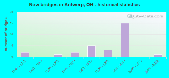
- New bridges - historical statistics
- 21940-1949
- 11960-1969
- 21970-1979
- 51980-1989
- 31990-1999
- 152000-2009
- 12020-2022


- Bridge Condition - Deck
- 15.8%Excellent
- 47.4%Very good
- 10.5%Good
- 21.1%Satisfactory
- 5.3%Fair

- Bridge Condition - Superstructure
- 42.1%Excellent
- 15.8%Very good
- 10.5%Good
- 21.1%Satisfactory
- 10.5%Fair

- Bridge Condition - Substructure
- 36.8%Excellent
- 26.3%Very good
- 10.5%Good
- 21.1%Satisfactory
- 5.3%Poor

- Bridge Condition - Channel
- 29.4%Excellent
- 41.2%Very good
- 11.8%Good
- 5.9%Satisfactory
- 11.8%Fair

- Bridge Condition - Culverts
- 80.0%Excellent
- 20.0%Fair
Find on map >> Show street view
Structure Number: 6300014, Location: US-24 OVER CR-11 (Lat: 41.160411, Lng: -84.785250), Route carried "on" structure: US 24, Year Built: 2009, Status: Open, Structure Length: 2.32m (7.61ft), Average Daily Traffic: 3,846 (year 2015), Truck Traffic: 42%, Average Future Daily Traffic: 5,338 (year 2035), Design Load: HS 25 or greater, Features Intersected: CR 11
Minimum Vertical Clearance: 30+ m (98+ ft), Kilometerpoint: 1.706, Lanes on structure: 2, Lanes under structure: 2, Base Highway Network: Yes, Owner: State Highway Agency, Approaching Roadway Width: 11.6m (38.1ft), Skew: 2 degrees, Material/Design: Prestressed concrete, Design/Construction: Stringer/Multi-beam, Number Of Spans In Main Unit: 1, Length of Maximum Span: 21.6m (70.9ft), Curb-To-Curb Width: 12.8m (42.0ft), Out-to-Out Width: 13.7m (44.9ft)
Condition: Deck: Very good, Superstructure: Excellent, Substructure: Excellent, Operating Rating: 42.1 metric tons, Method Used To Determine Operating Rating: Load Factor (LF) rating reported by rating factor (RF) method using MS18 loading, Inventory Rating: 32.4 metric tons, Method Used To Determine Inventory Rating: Load Factor (LF) rating reported by rating factor (RF) method using MS18 loading, Structural Evaluation: Equal to present desirable criteria, Deck Geometry: Equal to present minimum criteria, Underclear: Better than present minimum criteria, Approach Roadway Alignment: Equal to present desirable criteria, Designated Inspection Frequency: Every 24 months, Inspection Date: May 2020, Deck Structure Type: Concrete Cast-file-Place, Wearing Surface/Protective System: Wearing Surface: Integral Concrete, Deck Protection: Epoxy Coated Reinforcing
Find on map >> Show street view
Structure Number: 6300022, Location: US-24 OVER CR-11 (Lat: 41.160119, Lng: -84.785239), Route carried "on" structure: US 24, Year Built: 2009, Status: Open, Structure Length: 2.32m (7.61ft), Average Daily Traffic: 3,846 (year 2015), Truck Traffic: 42%, Average Future Daily Traffic: 5,338 (year 2035), Design Load: HS 25 or greater, Features Intersected: CR 11
Minimum Vertical Clearance: 30+ m (98+ ft), Kilometerpoint: 1.706, Lanes on structure: 2, Lanes under structure: 2, Base Highway Network: Yes, Owner: State Highway Agency, Approaching Roadway Width: 11.6m (38.1ft), Skew: 2 degrees, Material/Design: Prestressed concrete, Design/Construction: Stringer/Multi-beam, Number Of Spans In Main Unit: 1, Length of Maximum Span: 21.6m (70.9ft), Curb-To-Curb Width: 12.8m (42.0ft), Out-to-Out Width: 13.7m (44.9ft)
Condition: Deck: Very good, Superstructure: Excellent, Substructure: Excellent, Operating Rating: 42.1 metric tons, Method Used To Determine Operating Rating: Load Factor (LF) rating reported by rating factor (RF) method using MS18 loading, Inventory Rating: 32.4 metric tons, Method Used To Determine Inventory Rating: Load Factor (LF) rating reported by rating factor (RF) method using MS18 loading, Structural Evaluation: Equal to present desirable criteria, Deck Geometry: Equal to present minimum criteria, Underclear: Better than present minimum criteria, Approach Roadway Alignment: Equal to present desirable criteria, Designated Inspection Frequency: Every 24 months, Inspection Date: May 2020, Deck Structure Type: Concrete Cast-file-Place, Wearing Surface/Protective System: Deck Protection: Epoxy Coated Reinforcing
Find on map >> Show street view
Structure Number: 6300073, Location: US-24-OVER RMW R/R (Lat: 41.162631, Lng: -84.780111), Route carried "on" structure: US 24, Year Built: 2009, Status: Open, Structure Length: 3.32m (10.89ft), Average Daily Traffic: 3,846 (year 2015), Truck Traffic: 42%, Average Future Daily Traffic: 5,338 (year 2035), Design Load: HS 25 or greater, Features Intersected: MAUMEE & WESTERN (RMW) R
Minimum Vertical Clearance: 30+ m (98+ ft), Kilometerpoint: 2.205, Lanes on structure: 2, Base Highway Network: Yes, Owner: State Highway Agency, Approaching Roadway Width: 11.6m (38.1ft), Skew: 5 degrees, Material/Design: Prestressed concrete, Design/Construction: Stringer/Multi-beam, Number Of Spans In Main Unit: 1, Length of Maximum Span: 31.7m (104.0ft), Curb-To-Curb Width: 12.8m (42.0ft), Out-to-Out Width: 13.7m (44.9ft)
Condition: Deck: Very good, Superstructure: Excellent, Substructure: Excellent, Operating Rating: 42.1 metric tons, Method Used To Determine Operating Rating: Load Factor (LF) rating reported by rating factor (RF) method using MS18 loading, Inventory Rating: 32.4 metric tons, Method Used To Determine Inventory Rating: Load Factor (LF) rating reported by rating factor (RF) method using MS18 loading, Structural Evaluation: Equal to present desirable criteria, Deck Geometry: Equal to present minimum criteria, Underclear: Superior to present desirable criteria, Approach Roadway Alignment: Equal to present desirable criteria, Designated Inspection Frequency: Every 24 months, Inspection Date: May 2020, Deck Structure Type: Concrete Cast-file-Place, Wearing Surface/Protective System: Wearing Surface: Monolithic Concrete, Deck Protection: Epoxy Coated Reinforcing
Find on map >> Show street view
Structure Number: 6300081, Location: US-24 OVER THE RMW R/R (Lat: 41.162289, Lng: -84.780281), Route carried "on" structure: US 24, Year Built: 2009, Status: Open, Structure Length: 3.32m (10.89ft), Average Daily Traffic: 3,846 (year 2015), Truck Traffic: 42%, Average Future Daily Traffic: 5,338 (year 2035), Design Load: HS 25 or greater, Features Intersected: MAUMEE & WESTERN (RMW) R
Minimum Vertical Clearance: 30+ m (98+ ft), Kilometerpoint: 2.205, Lanes on structure: 2, Base Highway Network: Yes, Owner: State Highway Agency, Approaching Roadway Width: 11.6m (38.1ft), Skew: 5 degrees, Material/Design: Prestressed concrete, Design/Construction: Stringer/Multi-beam, Number Of Spans In Main Unit: 1, Length of Maximum Span: 31.7m (104.0ft), Curb-To-Curb Width: 12.8m (42.0ft), Out-to-Out Width: 13.7m (44.9ft)
Condition: Deck: Very good, Superstructure: Excellent, Substructure: Very good, Operating Rating: 42.1 metric tons, Method Used To Determine Operating Rating: Load Factor (LF) rating reported by rating factor (RF) method using MS18 loading, Inventory Rating: 32.4 metric tons, Method Used To Determine Inventory Rating: Load Factor (LF) rating reported by rating factor (RF) method using MS18 loading, Structural Evaluation: Equal to present desirable criteria, Deck Geometry: Equal to present minimum criteria, Underclear: Superior to present desirable criteria, Approach Roadway Alignment: Equal to present desirable criteria, Designated Inspection Frequency: Every 24 months, Inspection Date: May 2020, Deck Structure Type: Concrete Cast-file-Place, Wearing Surface/Protective System: Wearing Surface: Monolithic Concrete, Deck Protection: Epoxy Coated Reinforcing
Find on map >> Show street view
Structure Number: 6300111, Location: .5 MILES EAST OF SR 49 (Lat: 41.169450, Lng: -84.730089), Route carried "on" structure: US 24, Year Built: 2009, Status: Open, Structure Length: 0.98m (3.22ft), Average Daily Traffic: 7,692 (year 2015), Truck Traffic: 42%, Average Future Daily Traffic: 10,676 (year 2035), Design Load: HS 25 or greater, Features Intersected: STREAM
Minimum Vertical Clearance: 30+ m (98+ ft), Kilometerpoint: 6.518, Lanes on structure: 4, Base Highway Network: Yes, Owner: State Highway Agency, Approaching Roadway Width: 11.6m (38.1ft), Skew: 6 degrees, Material/Design: Concrete, Design/Construction: Culvert, Number Of Spans In Main Unit: 1, Length of Maximum Span: 9.1m (29.9ft)
Condition: Channel: Excellent, Culverts: Excellent, Operating Rating: 42.1 metric tons, Method Used To Determine Operating Rating: Load Factor (LF) rating reported by rating factor (RF) method using MS18 loading, Inventory Rating: 32.4 metric tons, Method Used To Determine Inventory Rating: Load Factor (LF) rating reported by rating factor (RF) method using MS18 loading, Structural Evaluation: Equal to present desirable criteria, Waterway Adequacy: Superior to present desirable criteria, Approach Roadway Alignment: Equal to present desirable criteria, Designated Inspection Frequency: Every 24 months, Inspection Date: May 2020
Find on map >> Show street view
Structure Number: 6300138, Location: 0.45 mi. E. of SR 49 (Lat: 41.169661, Lng: -84.727169), Route carried "on" structure: County highway C0043, Year Built: 2008, Status: Open, Structure Length: 6.10m (20.01ft), Average Daily Traffic: 100 (year 2018), Truck Traffic: 10%, Average Future Daily Traffic: 139 (year 2038), Design Load: HS 25 or greater, Features Intersected: USR 24, Facility Carried by Structure: CR 43
Minimum Vertical Clearance: 30+ m (98+ ft), Kilometerpoint: 0.565, Lanes on structure: 2, Lanes under structure: 4, Owner: State Highway Agency, Approaching Roadway Width: 9.1m (29.9ft), Skew: 1 degrees, Material/Design: Prestressed concrete continuous, Design/Construction: Stringer/Multi-beam, Number Of Spans In Main Unit: 2, Length of Maximum Span: 29.6m (97.1ft), Curb-To-Curb Width: 9.1m (29.9ft), Out-to-Out Width: 10.1m (33.1ft)
Condition: Deck: Excellent, Superstructure: Excellent, Substructure: Excellent, Operating Rating: 42.1 metric tons, Method Used To Determine Operating Rating: Load Factor (LF) rating reported by rating factor (RF) method using MS18 loading, Inventory Rating: 32.4 metric tons, Method Used To Determine Inventory Rating: Load Factor (LF) rating reported by rating factor (RF) method using MS18 loading, Structural Evaluation: Equal to present desirable criteria, Deck Geometry: Better than present minimum criteria, Underclear: Equal to present minimum criteria, Approach Roadway Alignment: Equal to present desirable criteria, Designated Inspection Frequency: Every 24 months, Inspection Date: May 2020, Deck Structure Type: Concrete Cast-file-Place, Wearing Surface/Protective System: Wearing Surface: Monolithic Concrete, Deck Protection: Epoxy Coated Reinforcing
Find on map >> Show street view
Structure Number: 6300146, Location: 1.6 mi. E. OF SR-49 (Lat: 41.179219, Lng: -84.708269), Route carried "on" structure: County highway C0176, Year Built: 2008, Status: Open, Structure Length: 7.77m (25.49ft), Average Daily Traffic: 832 (year 2016), Truck Traffic: 1%, Average Future Daily Traffic: 1,155 (year 2036), Design Load: HS 25 or greater, Features Intersected: USR 24, Facility Carried by Structure: CR 176
Minimum Vertical Clearance: 30+ m (98+ ft), Kilometerpoint: 1.593, Lanes on structure: 2, Lanes under structure: 4, Owner: State Highway Agency, Approaching Roadway Width: 9.8m (32.2ft), Skew: 4 degrees, Material/Design: Prestressed concrete continuous, Design/Construction: Stringer/Multi-beam, Number Of Spans In Main Unit: 2, Length of Maximum Span: 37.5m (123.0ft), Curb-To-Curb Width: 12.2m (40.0ft), Out-to-Out Width: 13.1m (43.0ft)
Condition: Deck: Very good, Superstructure: Excellent, Substructure: Excellent, Operating Rating: 42.1 metric tons, Method Used To Determine Operating Rating: Load Factor (LF) rating reported by rating factor (RF) method using MS18 loading, Inventory Rating: 32.4 metric tons, Method Used To Determine Inventory Rating: Load Factor (LF) rating reported by rating factor (RF) method using MS18 loading, Structural Evaluation: Equal to present desirable criteria, Deck Geometry: Equal to present desirable criteria, Underclear: Equal to present minimum criteria, Approach Roadway Alignment: Better than present minimum criteria, Designated Inspection Frequency: Every 24 months, Inspection Date: May 2020, Deck Structure Type: Concrete Cast-file-Place, Wearing Surface/Protective System: Wearing Surface: Monolithic Concrete, Deck Protection: Epoxy Coated Reinforcing
Find on map >> Show street view
Structure Number: 6300162, Location: US-24 OVER NORTH CREEK (Lat: 41.172050, Lng: -84.720200), Route carried "on" structure: US 24, Year Built: 2009, Status: Open, Structure Length: 0.67m (2.20ft), Average Daily Traffic: 8,789 (year 2015), Truck Traffic: 41%, Average Future Daily Traffic: 12,199 (year 2035), Design Load: HS 25 or greater, Features Intersected: STREAM
Minimum Vertical Clearance: 30+ m (98+ ft), Kilometerpoint: 7.403, Lanes on structure: 4, Owner: State Highway Agency, Approaching Roadway Width: 11.6m (38.1ft), Skew: 4 degrees, Material/Design: Concrete, Design/Construction: Culvert, Number Of Spans In Main Unit: 1, Length of Maximum Span: 6.1m (20.0ft)
Condition: Channel: Excellent, Culverts: Excellent, Operating Rating: 42.1 metric tons, Method Used To Determine Operating Rating: Load Factor (LF) rating reported by rating factor (RF) method using MS18 loading, Inventory Rating: 32.4 metric tons, Method Used To Determine Inventory Rating: Load Factor (LF) rating reported by rating factor (RF) method using MS18 loading, Structural Evaluation: Equal to present desirable criteria, Waterway Adequacy: Equal to present desirable criteria, Approach Roadway Alignment: Equal to present desirable criteria, Designated Inspection Frequency: Every 24 months, Inspection Date: May 2020
Find on map >> Show street view
Structure Number: 630017, Location: US-24 OVER ZUBER CUTOFF (Lat: 41.194811, Lng: -84.684550), Route carried "on" structure: US 24, Year Built: 2009, Status: Open, Structure Length: 0.91m (2.99ft), Average Daily Traffic: 8,789 (year 2015), Truck Traffic: 41%, Average Future Daily Traffic: 12,199 (year 2035), Design Load: HS 25 or greater, Features Intersected: ZUBER CUTOFF
Minimum Vertical Clearance: 30+ m (98+ ft), Kilometerpoint: 11.346, Lanes on structure: 4, Base Highway Network: Yes, Owner: State Highway Agency, Approaching Roadway Width: 11.6m (38.1ft), Material/Design: Concrete, Design/Construction: Culvert, Number Of Spans In Main Unit: 1, Length of Maximum Span: 8.5m (27.9ft)
Condition: Channel: Good, Culverts: Excellent, Operating Rating: 42.1 metric tons, Method Used To Determine Operating Rating: Load Factor (LF) rating reported by rating factor (RF) method using MS18 loading, Inventory Rating: 32.4 metric tons, Method Used To Determine Inventory Rating: Load Factor (LF) rating reported by rating factor (RF) method using MS18 loading, Structural Evaluation: Equal to present desirable criteria, Waterway Adequacy: Superior to present desirable criteria, Approach Roadway Alignment: Equal to present desirable criteria, Designated Inspection Frequency: Every 24 months, Inspection Date: May 2020
Find on map >> Show street view
Structure Number: 6300324, Location: 1.33 mi. South of USR 24 (Lat: 41.150789, Lng: -84.727231), Route carried "on" structure: State highway 49, Year Built: 1987, Status: Open, Structure Length: 1.22m (4.00ft), Average Daily Traffic: 2,499 (year 2015), Truck Traffic: 14%, Average Future Daily Traffic: 3,469 (year 2035), Design Load: HS 20+Mod, Features Intersected: SOUTH CREEK
Minimum Vertical Clearance: 30+ m (98+ ft), Kilometerpoint: 17.976, Lanes on structure: 2, Owner: State Highway Agency, Approaching Roadway Width: 12.2m (40.0ft), Material/Design: Prestressed concrete, Design/Construction: Box Beam or Girders - Multiple, Number Of Spans In Main Unit: 1, Length of Maximum Span: 11.6m (38.1ft), Curb-To-Curb Width: 12.2m (40.0ft), Out-to-Out Width: 12.2m (40.0ft)
Condition: Deck: Very good, Superstructure: Very good, Substructure: Good, Channel: Excellent, Operating Rating: 42.1 metric tons, Method Used To Determine Operating Rating: Load Factor (LF) rating reported by rating factor (RF) method using MS18 loading, Inventory Rating: 32.4 metric tons, Method Used To Determine Inventory Rating: Load Factor (LF) rating reported by rating factor (RF) method using MS18 loading, Structural Evaluation: Better than present minimum criteria, Deck Geometry: Equal to present minimum criteria, Waterway Adequacy: Equal to present desirable criteria, Approach Roadway Alignment: Equal to present desirable criteria, Designated Inspection Frequency: Every 24 months, Inspection Date: April 2020, Deck Structure Type: Concrete Cast-file-Place, Wearing Surface/Protective System: Wearing Surface: Monolithic Concrete, Deck Protection: Epoxy Coated Reinforcing
Find on map >> Show street view
Structure Number: 6300383, Location: .25 MI SOUTH OF ANTWERP (Lat: 41.168581, Lng: -84.735819), Route carried "on" structure: State highway 49, Year Built: 2008, Status: Open, Structure Length: 5.58m (18.31ft), Average Daily Traffic: 2,499 (year 2015), Truck Traffic: 14%, Average Future Daily Traffic: 3,469 (year 2035), Design Load: HS 25 or greater, Features Intersected: USR 24
Minimum Vertical Clearance: 30+ m (98+ ft), Kilometerpoint: 20.036, Lanes on structure: 2, Lanes under structure: 4, Owner: State Highway Agency, Approaching Roadway Width: 12.2m (40.0ft), Material/Design: Prestressed concrete continuous, Design/Construction: Stringer/Multi-beam, Number Of Spans In Main Unit: 2, Length of Maximum Span: 27.1m (88.9ft), Curb-To-Curb Width: 13.4m (44.0ft), Out-to-Out Width: 14.3m (46.9ft)
Condition: Deck: Excellent, Superstructure: Excellent, Substructure: Excellent, Operating Rating: 42.1 metric tons, Method Used To Determine Operating Rating: Load Factor (LF) rating reported by rating factor (RF) method using MS18 loading, Inventory Rating: 32.4 metric tons, Method Used To Determine Inventory Rating: Load Factor (LF) rating reported by rating factor (RF) method using MS18 loading, Structural Evaluation: Equal to present desirable criteria, Deck Geometry: Better than present minimum criteria, Underclear: Better than present minimum criteria, Approach Roadway Alignment: Better than present minimum criteria, Designated Inspection Frequency: Every 24 months, Inspection Date: April 2020, Deck Structure Type: Concrete Cast-file-Place, Wearing Surface/Protective System: Wearing Surface: Monolithic Concrete, Deck Protection: Epoxy Coated Reinforcing
Find on map >> Show street view
Structure Number: 6300391, Location: 0.62 mi. North of Antwerp (Lat: 41.197839, Lng: -84.746789), Route carried "on" structure: State highway 49, Year Built: 1948, Status: Open, Structure Length: 13.44m (44.09ft), Average Daily Traffic: 1,975 (year 2015), Truck Traffic: 7%, Average Future Daily Traffic: 2,741 (year 2035), Design Load: H 15, Features Intersected: MAUMEE RIVER
Minimum Vertical Clearance: 30+ m (98+ ft), Kilometerpoint: 23.657, Lanes on structure: 2, Owner: State Highway Agency, Approaching Roadway Width: 7.6m (24.9ft), Skew: 1 degrees, Material/Design: Steel continuous, Design/Construction: Stringer/Multi-beam, Number Of Spans In Main Unit: 4, Length of Maximum Span: 36.3m (119.1ft), Curb-To-Curb Width: 8.1m (26.6ft), Out-to-Out Width: 9.1m (29.9ft)
Condition: Deck: Good, Superstructure: Satisfactory, Substructure: Satisfactory, Channel: Fair, Operating Rating: 61.6 metric tons, Method Used To Determine Operating Rating: Load Factor (LF) rating reported by rating factor (RF) method using MS18 loading, Inventory Rating: 35.6 metric tons, Method Used To Determine Inventory Rating: Load Factor (LF) rating reported by rating factor (RF) method using MS18 loading, Structural Evaluation: Equal to present minimum criteria, Deck Geometry: Meets minimum limits, Waterway Adequacy: Equal to present desirable criteria, Approach Roadway Alignment: Somewhat better than minimum adequacy, Designated Inspection Frequency: Every 12 months, Underwater Inspection Frequency: Every 60 months, Inspection Date: April 2021, Underwater Inspection Date: May 2021, Deck Structure Type: Concrete Cast-file-Place, Wearing Surface/Protective System: Wearing Surface: Integral Concrete
Find on map >> Show street view
Structure Number: 6300413, Location: 2.3 mi. S of DEF/PAU Co. (Lat: 41.219839, Lng: -84.751281), Route carried "on" structure: State highway 49, Year Built: 1979, Status: Open, Structure Length: 2.47m (8.10ft), Average Daily Traffic: 1,975 (year 2015), Truck Traffic: 7%, Average Future Daily Traffic: 2,741 (year 2035), Design Load: HS 20+Mod, Features Intersected: S BRANCH MARIE DELARME C
Minimum Vertical Clearance: 30+ m (98+ ft), Kilometerpoint: 26.136, Lanes on structure: 2, Owner: State Highway Agency, Approaching Roadway Width: 13.4m (44.0ft), Skew: 3 degrees, Material/Design: Concrete continuous, Design/Construction: Slab, Number Of Spans In Main Unit: 3, Length of Maximum Span: 9.1m (29.9ft), Curb-To-Curb Width: 13.4m (44.0ft), Out-to-Out Width: 13.8m (45.3ft)
Condition: Deck: Satisfactory, Superstructure: Satisfactory, Substructure: Satisfactory, Channel: Excellent, Operating Rating: 42.1 metric tons, Method Used To Determine Operating Rating: Load Factor (LF) rating reported by rating factor (RF) method using MS18 loading, Inventory Rating: 32.4 metric tons, Method Used To Determine Inventory Rating: Load Factor (LF) rating reported by rating factor (RF) method using MS18 loading, Structural Evaluation: Equal to present minimum criteria, Deck Geometry: Equal to present desirable criteria, Waterway Adequacy: Equal to present desirable criteria, Approach Roadway Alignment: Equal to present desirable criteria, Designated Inspection Frequency: Every 12 months, Inspection Date: May 2021, Deck Structure Type: Concrete Cast-file-Place, Wearing Surface/Protective System: Wearing Surface: Epoxy Overlay
Find on map >> Show street view
Structure Number: 6330053, Location: 2 MI EAST OF ANTWERP (Lat: 41.201500, Lng: -84.693311), Route carried "on" structure: County highway C0424, Year Built: 1996, Status: Open, Structure Length: 5.52m (18.11ft), Average Daily Traffic: 807 (year 2015), Truck Traffic: 6%, Average Future Daily Traffic: 1,120 (year 2035), Design Load: HS 20+Mod, Features Intersected: ZUBER CUTOFF, Facility Carried by Structure: COUNTY ROAD 424
Minimum Vertical Clearance: 30+ m (98+ ft), Kilometerpoint: 10.493, Lanes on structure: 2, Owner: County Highway Agency, Approaching Roadway Width: 13.4m (44.0ft), Skew: 3 degrees, Material/Design: Prestressed concrete continuous, Design/Construction: Box Beam or Girders - Multiple, Number Of Spans In Main Unit: 3, Length of Maximum Span: 20.7m (67.9ft), Curb-To-Curb Width: 13.4m (44.0ft), Out-to-Out Width: 13.4m (44.0ft)
Condition: Deck: Good, Superstructure: Good, Substructure: Very good, Channel: Fair, Operating Rating: 42.1 metric tons, Method Used To Determine Operating Rating: Load Factor (LF) rating reported by rating factor (RF) method using MS18 loading, Inventory Rating: 32.4 metric tons, Method Used To Determine Inventory Rating: Load Factor (LF) rating reported by rating factor (RF) method using MS18 loading, Structural Evaluation: Better than present minimum criteria, Deck Geometry: Superior to present desirable criteria, Waterway Adequacy: Superior to present desirable criteria, Approach Roadway Alignment: Equal to present desirable criteria, Designated Inspection Frequency: Every 24 months, Inspection Date: September 2020, Deck Structure Type: Corrugated Steel, Wearing Surface/Protective System: Wearing Surface: Bituminous
Find on map >> Show street view
Structure Number: 6330789, Location: 0.4 MI W OF JCT T61 (Lat: 41.165000, Lng: -84.695000), Route carried "on" structure: County highway T0162, Year Built: 1987, Status: Open, Structure Length: 2.10m (6.89ft), Average Daily Traffic: 171 (year 2015), Truck Traffic: 8%, Average Future Daily Traffic: 237 (year 2035), Design Load: HS 20, Features Intersected: SOUTH CREEK, Facility Carried by Structure: TOWNSHIP ROAD 162
Minimum Vertical Clearance: 30+ m (98+ ft), Kilometerpoint: 5.794, Lanes on structure: 2, Owner: County Highway Agency, Approaching Roadway Width: 9.8m (32.2ft), Skew: 4 degrees, Material/Design: Prestressed concrete, Design/Construction: Box Beam or Girders - Multiple, Number Of Spans In Main Unit: 1, Length of Maximum Span: 21.0m (68.9ft), Curb-To-Curb Width: 8.5m (27.9ft), Out-to-Out Width: 8.5m (27.9ft)
Condition: Deck: Very good, Superstructure: Very good, Substructure: Good, Channel: Very good, Operating Rating: 61.6 metric tons, Method Used To Determine Operating Rating: Load Factor (LF) rating reported by rating factor (RF) method using MS18 loading, Inventory Rating: 35.6 metric tons, Method Used To Determine Inventory Rating: Load Factor (LF) rating reported by rating factor (RF) method using MS18 loading, Structural Evaluation: Better than present minimum criteria, Deck Geometry: Equal to present minimum criteria, Waterway Adequacy: Equal to present desirable criteria, Approach Roadway Alignment: Equal to present minimum criteria, Length Of Structure Improvement: 4.57m (14.99ft), Designated Inspection Frequency: Every 24 months, Inspection Date: September 2020, Bridge Improvement Cost: $84,000, Roadway Improvement Cost: $31,000, Total Project Cost: $139,000, Deck Structure Type: Concrete Cast-file-Place, Wearing Surface/Protective System: Wearing Surface: Bituminous
Find on map >> Show street view
Structure Number: 6331017, Location: 0.3 MI E OF JCT T61 (Lat: 41.191669, Lng: -84.681669), Route carried "on" structure: County highway C0180, Year Built: 1985, Status: Open, Structure Length: 3.23m (10.60ft), Average Daily Traffic: 932 (year 2015), Truck Traffic: 8%, Average Future Daily Traffic: 1,294 (year 2035), Design Load: HS 20, Features Intersected: ZUBER CUTOFF, Facility Carried by Structure: COUNTY ROAD 180
Minimum Vertical Clearance: 30+ m (98+ ft), Kilometerpoint: 3.750, Lanes on structure: 2, Owner: County Highway Agency, Approaching Roadway Width: 10.7m (35.1ft), Material/Design: Prestressed concrete, Design/Construction: Box Beam or Girders - Multiple, Number Of Spans In Main Unit: 3, Length of Maximum Span: 10.7m (35.1ft), Curb-To-Curb Width: 8.5m (27.9ft), Out-to-Out Width: 8.5m (27.9ft)
Condition: Deck: Fair, Superstructure: Fair, Substructure: Satisfactory, Channel: Very good, Operating Rating: 61.6 metric tons, Method Used To Determine Operating Rating: Load Factor (LF) rating reported by rating factor (RF) method using MS18 loading, Inventory Rating: 35.6 metric tons, Method Used To Determine Inventory Rating: Load Factor (LF) rating reported by rating factor (RF) method using MS18 loading, Structural Evaluation: Somewhat better than minimum adequacy, Deck Geometry: Somewhat better than minimum adequacy, Waterway Adequacy: Superior to present desirable criteria, Approach Roadway Alignment: Equal to present minimum criteria, Designated Inspection Frequency: Every 12 months, Inspection Date: July 2021, Deck Structure Type: Concrete Cast-file-Place, Wearing Surface/Protective System: Wearing Surface: Bituminous
Find on map >> Show street view
Structure Number: 6333915, Location: 0.4 MI S OF JCT C230 (Lat: 41.231669, Lng: -84.708331), Route carried "on" structure: County highway T0053, Year Built: 1988, Status: Open, Structure Length: 2.53m (8.30ft), Average Daily Traffic: 324 (year 2015), Truck Traffic: 7%, Average Future Daily Traffic: 450 (year 2035), Design Load: HS 20, Features Intersected: MARIE DELARME CREEK, Facility Carried by Structure: TOWNSHIP ROAD 53
Minimum Vertical Clearance: 30+ m (98+ ft), Kilometerpoint: 4.233, Lanes on structure: 2, Owner: County Highway Agency, Approaching Roadway Width: 9.1m (29.9ft), Material/Design: Prestressed concrete, Design/Construction: Box Beam or Girders - Multiple, Number Of Spans In Main Unit: 3, Length of Maximum Span: 8.5m (27.9ft), Curb-To-Curb Width: 8.5m (27.9ft), Out-to-Out Width: 8.5m (27.9ft)
Condition: Deck: Excellent, Superstructure: Excellent, Substructure: Very good, Channel: Very good, Operating Rating: 81.0 metric tons, Method Used To Determine Operating Rating: Load Factor (LF) rating reported by rating factor (RF) method using MS18 loading, Inventory Rating: 48.6 metric tons, Method Used To Determine Inventory Rating: Load Factor (LF) rating reported by rating factor (RF) method using MS18 loading, Structural Evaluation: Equal to present desirable criteria, Deck Geometry: Equal to present minimum criteria, Waterway Adequacy: Equal to present minimum criteria, Approach Roadway Alignment: Somewhat better than minimum adequacy, Length Of Structure Improvement: 12.50m (41.01ft), Designated Inspection Frequency: Every 24 months, Inspection Date: December 2021, Bridge Improvement Cost: $98,000, Roadway Improvement Cost: $59,000, Total Project Cost: $185,000, Deck Structure Type: Concrete Cast-file-Place, Wearing Surface/Protective System: Wearing Surface: Bituminous
Find on map >> Show street view
Structure Number: 6334075, Location: 0.28MI E. OF C45 ON C230 (Lat: 41.237439, Lng: -84.722450), Route carried "on" structure: County highway C0230, Year Built: 1998, Status: Open, Structure Length: 1.74m (5.71ft), Average Daily Traffic: 102 (year 2015), Truck Traffic: 7%, Average Future Daily Traffic: 142 (year 2035), Design Load: HS 20+Mod, Features Intersected: N. BRANCH MARIE DELARME, Facility Carried by Structure: COUNTY ROAD 230
Minimum Vertical Clearance: 30+ m (98+ ft), Kilometerpoint: 6.888, Lanes on structure: 2, Owner: County Highway Agency, Approaching Roadway Width: 8.5m (27.9ft), Skew: 3 degrees, Material/Design: Prestressed concrete, Design/Construction: Box Beam or Girders - Multiple, Number Of Spans In Main Unit: 1, Length of Maximum Span: 17.1m (56.1ft), Curb-To-Curb Width: 8.5m (27.9ft), Out-to-Out Width: 8.5m (27.9ft)
Condition: Deck: Very good, Superstructure: Very good, Substructure: Very good, Channel: Excellent, Operating Rating: 42.1 metric tons, Method Used To Determine Operating Rating: Load Factor (LF) rating reported by rating factor (RF) method using MS18 loading, Inventory Rating: 32.4 metric tons, Method Used To Determine Inventory Rating: Load Factor (LF) rating reported by rating factor (RF) method using MS18 loading, Structural Evaluation: Equal to present desirable criteria, Deck Geometry: Equal to present minimum criteria, Waterway Adequacy: Superior to present desirable criteria, Approach Roadway Alignment: Equal to present desirable criteria, Designated Inspection Frequency: Every 24 months, Inspection Date: December 2021, Deck Structure Type: Concrete Cast-file-Place, Wearing Surface/Protective System: Wearing Surface: Bituminous, Membrane: Preformed Fabric, Deck Protection: Epoxy Coated Reinforcing
Find on map >> Show street view
Structure Number: 6334113, Location: 0.06 mile N. of CR 230 (Lat: 41.238269, Lng: -84.727739), Route carried "on" structure: County highway C0045, Year Built: 1975, Status: Open, Structure Length: 1.59m (5.22ft), Average Daily Traffic: 385 (year 2015), Truck Traffic: 8%, Average Future Daily Traffic: 534 (year 2035), Design Load: HS 20+Mod, Features Intersected: NO BR MARIE DELARME CREE, Facility Carried by Structure: COUNTY ROAD 45
Minimum Vertical Clearance: 30+ m (98+ ft), Kilometerpoint: 4.908, Lanes on structure: 2, Owner: County Highway Agency, Approaching Roadway Width: 7.3m (24.0ft), Material/Design: Prestressed concrete, Design/Construction: Box Beam or Girders - Multiple, Number Of Spans In Main Unit: 1, Length of Maximum Span: 15.9m (52.2ft), Curb-To-Curb Width: 7.3m (24.0ft), Out-to-Out Width: 7.3m (24.0ft)
Condition: Deck: Very good, Superstructure: Good, Substructure: Satisfactory, Channel: Satisfactory, Operating Rating: 42.1 metric tons, Method Used To Determine Operating Rating: Load Factor (LF) rating reported by rating factor (RF) method using MS18 loading, Inventory Rating: 32.4 metric tons, Method Used To Determine Inventory Rating: Load Factor (LF) rating reported by rating factor (RF) method using MS18 loading, Structural Evaluation: Equal to present minimum criteria, Deck Geometry: Somewhat better than minimum adequacy, Waterway Adequacy: Equal to present desirable criteria, Approach Roadway Alignment: Better than present minimum criteria, Designated Inspection Frequency: Every 12 months, Inspection Date: August 2021, Deck Structure Type: Concrete Cast-file-Place, Wearing Surface/Protective System: Wearing Surface: Bituminous
Find on map >> Show street view
Structure Number: 6334156, Location: 0.6 MI S OF JCT C176 (Lat: 41.170000, Lng: -84.688331), Route carried "on" structure: County highway T0061, Year Built: 1985, Status: Open, Structure Length: 2.90m (9.51ft), Average Daily Traffic: 209 (year 2015), Truck Traffic: 7%, Average Future Daily Traffic: 290 (year 2035), Design Load: HS 20, Features Intersected: SOUTH CREEK, Facility Carried by Structure: TOWNSHIP ROAD 61
Minimum Vertical Clearance: 30+ m (98+ ft), Kilometerpoint: 8.690, Lanes on structure: 2, Owner: County Highway Agency, Approaching Roadway Width: 7.3m (24.0ft), Skew: 5 degrees, Material/Design: Prestressed concrete, Design/Construction: Box Beam or Girders - Multiple, Number Of Spans In Main Unit: 3, Length of Maximum Span: 9.8m (32.2ft), Curb-To-Curb Width: 7.3m (24.0ft), Out-to-Out Width: 7.3m (24.0ft)
Condition: Deck: Satisfactory, Superstructure: Satisfactory, Substructure: Very good, Channel: Very good, Operating Rating: 84.2 metric tons, Method Used To Determine Operating Rating: Load Factor (LF) rating reported by rating factor (RF) method using MS18 loading, Inventory Rating: 48.6 metric tons, Method Used To Determine Inventory Rating: Load Factor (LF) rating reported by rating factor (RF) method using MS18 loading, Structural Evaluation: Equal to present minimum criteria, Deck Geometry: Somewhat better than minimum adequacy, Waterway Adequacy: Equal to present minimum criteria, Approach Roadway Alignment: Somewhat better than minimum adequacy, Designated Inspection Frequency: Every 12 months, Inspection Date: December 2021, Deck Structure Type: Concrete Cast-file-Place, Wearing Surface/Protective System: Wearing Surface: Monolithic Concrete
Find on map >> Show street view
Structure Number: 6334202, Location: 2.7 MI W OF JCT C87 (Lat: 41.180000, Lng: -84.683331), Route carried "on" structure: County highway C0176, Year Built: 1969, Status: Open, Structure Length: 0.91m (2.99ft), Average Daily Traffic: 811 (year 2015), Truck Traffic: 8%, Average Future Daily Traffic: 1,126 (year 2035), Features Intersected: SOUTH CREEK, Facility Carried by Structure: COUNTY ROAD 176
Minimum Vertical Clearance: 30+ m (98+ ft), Kilometerpoint: 3.621, Lanes on structure: 2, Owner: County Highway Agency, Approaching Roadway Width: 6.7m (22.0ft), Material/Design: Steel, Design/Construction: Culvert, Number Of Spans In Main Unit: 2, Length of Maximum Span: 4.3m (14.1ft)
Condition: Channel: Very good, Culverts: Fair, Operating Rating: 97.2 metric tons, Method Used To Determine Operating Rating: Load Factor (LF) rating reported by rating factor (RF) method using MS18 loading, Inventory Rating: 68.0 metric tons, Method Used To Determine Inventory Rating: Load Factor (LF) rating reported by rating factor (RF) method using MS18 loading, Structural Evaluation: Somewhat better than minimum adequacy, Waterway Adequacy: Meets minimum limits, Approach Roadway Alignment: Equal to present minimum criteria, Designated Inspection Frequency: Every 12 months, Inspection Date: December 2021
Find on map >> Show street view
Structure Number: 6334687, Location: 0.2 MI N OF JCT SR111 (Lat: 41.140000, Lng: -84.765000), Route carried "on" structure: County highway T0021, Year Built: 1940, Year Reconstructed: 1955, Status: Open, Structure Length: 0.70m (2.30ft), Average Daily Traffic: 659 (year 2015), Truck Traffic: 7%, Average Future Daily Traffic: 915 (year 2035), Features Intersected: SOUTH CREEK, Facility Carried by Structure: TOWNSHIP ROAD 21
Minimum Vertical Clearance: 30+ m (98+ ft), Kilometerpoint: 10.058, Lanes on structure: 2, Owner: County Highway Agency, Approaching Roadway Width: 6.7m (22.0ft), Skew: 1 degrees, Material/Design: Steel, Design/Construction: Stringer/Multi-beam, Number Of Spans In Main Unit: 1, Length of Maximum Span: 6.4m (21.0ft), Curb-To-Curb Width: 6.8m (22.3ft), Out-to-Out Width: 7.2m (23.6ft)
Condition: Deck: Satisfactory, Superstructure: Fair, Substructure: Poor, Channel: Very good, Operating Rating: 40.8 metric tons, Method Used To Determine Operating Rating: Field evaluation and documented engineering judgment, Inventory Rating: 32.7 metric tons, Method Used To Determine Inventory Rating: Field evaluation and documented engineering judgment, Structural Evaluation: Meets minimum limits, Deck Geometry: Meets minimum limits, Waterway Adequacy: Better than present minimum criteria, Approach Roadway Alignment: Somewhat better than minimum adequacy, Designated Inspection Frequency: Every 12 months, Inspection Date: July 2021, Deck Structure Type: Corrugated Steel, Wearing Surface/Protective System: Wearing Surface: Bituminous
Find on map >> Show street view
Structure Number: 6334726, Location: 0.06 mi west of SR49 (Lat: 41.150650, Lng: -84.728411), Route carried "on" structure: County highway T0144, Year Built: 2021, Status: Open, Structure Length: 0.88m (2.89ft), Average Daily Traffic: 94 (year 2021), Truck Traffic: 5%, Average Future Daily Traffic: 130 (year 2041), Design Load: HL 93, Features Intersected: South Creek, Facility Carried by Structure: Twp Rd 144
Minimum Vertical Clearance: 30+ m (98+ ft), Kilometerpoint: 4.699, Lanes on structure: 1, Owner: County Highway Agency, Approaching Roadway Width: 4.9m (16.1ft), Skew: 6 degrees, Material/Design: Concrete, Design/Construction: Culvert, Number Of Spans In Main Unit: 1, Length of Maximum Span: 8.1m (26.6ft)
Condition: Channel: Very good, Culverts: Excellent, Operating Rating: 59.0 metric tons, Method Used To Determine Operating Rating: Load and Resistance Factor Rating (LRFR) rating reported by rating factor(RF) method using HL-93 loadings, Inventory Rating: 45.4 metric tons, Method Used To Determine Inventory Rating: Load and Resistance Factor Rating (LRFR) rating reported by rating factor(RF) method using HL-93 loadings, Structural Evaluation: Superior to present desirable criteria, Waterway Adequacy: Superior to present desirable criteria, Approach Roadway Alignment: Better than present minimum criteria, Designated Inspection Frequency: Every 12 months, Inspection Date: November 2021
Find on map >> Show street view
Structure Number: 6334806, Location: 1.4 MI. N. OF JCT SR111 (Lat: 41.155000, Lng: -84.708331), Route carried "on" structure: County highway T0051, Year Built: 1990, Status: Open, Structure Length: 1.68m (5.51ft), Average Daily Traffic: 324 (year 2015), Truck Traffic: 7%, Average Future Daily Traffic: 450 (year 2035), Design Load: HS 20, Features Intersected: SOUTH CREEK, Facility Carried by Structure: TOWNSHIP ROAD 51
Minimum Vertical Clearance: 30+ m (98+ ft), Kilometerpoint: 8.610, Lanes on structure: 2, Owner: County Highway Agency, Approaching Roadway Width: 9.1m (29.9ft), Material/Design: Prestressed concrete, Design/Construction: Box Beam or Girders - Multiple, Number Of Spans In Main Unit: 1, Length of Maximum Span: 16.2m (53.1ft), Curb-To-Curb Width: 7.3m (24.0ft), Out-to-Out Width: 7.3m (24.0ft)
Condition: Deck: Satisfactory, Superstructure: Satisfactory, Substructure: Excellent, Channel: Good, Operating Rating: 42.1 metric tons, Method Used To Determine Operating Rating: Load Factor (LF) rating reported by rating factor (RF) method using MS18 loading, Inventory Rating: 32.4 metric tons, Method Used To Determine Inventory Rating: Load Factor (LF) rating reported by rating factor (RF) method using MS18 loading, Structural Evaluation: Equal to present minimum criteria, Deck Geometry: Somewhat better than minimum adequacy, Waterway Adequacy: Better than present minimum criteria, Approach Roadway Alignment: Meets minimum limits, Designated Inspection Frequency: Every 12 months, Inspection Date: July 2021, Deck Structure Type: Concrete Cast-file-Place, Wearing Surface/Protective System: Wearing Surface: Bituminous
Find on map >> Show street view
Structure Number: 6300014, Location: US-24 OVER CR-11 (Lat: 41.160411, Lng: -84.785250), Route carried "under" structure: County highway 11, Year Built: 2009, Structure Length: 0. m, Average Daily Traffic: 44 (year 2015), Truck Traffic: 7%, Features Intersected: USR 24, Facility Carried by Structure: USR 24 WB
Minimum Vertical Clearance: 4.95m (16.24ft), Kilometerpoint: 0.000, Lanes on structure: 2, Lanes under structure: 2, Material/Design: Prestressed concrete, Design/Construction: Stringer/Multi-beam, Length of Maximum Span: 21.6m (70.9ft)
Find on map >> Show street view
Structure Number: 6300022, Location: US-24 OVER CR-11 (Lat: 41.160119, Lng: -84.785239), Route carried "under" structure: County highway 11, Year Built: 2009, Structure Length: 0. m, Average Daily Traffic: 22 (year 2015), Truck Traffic: 9%, Features Intersected: CR 11, Facility Carried by Structure: USR 24 EB
Minimum Vertical Clearance: 4.95m (16.24ft), Kilometerpoint: 1.706, Lanes on structure: 2, Lanes under structure: 2, Material/Design: Prestressed concrete, Design/Construction: Stringer/Multi-beam, Length of Maximum Span: 21.6m (70.9ft)
Find on map >> Show street view
Structure Number: 6300138, Location: 0.45 mi. E. of SR 49 (Lat: 41.169661, Lng: -84.727169), Route carried "under" structure: US 24, Year Built: 2008, Structure Length: 0. m, Average Daily Traffic: 12,889 (year 2016), Truck Traffic: 52%, Features Intersected: CR 43, Facility Carried by Structure: CR 43
Minimum Vertical Clearance: 5.41m (17.75ft), Kilometerpoint: 6.766, Lanes on structure: 2, Lanes under structure: 4, Material/Design: Prestressed concrete continuous, Design/Construction: Stringer/Multi-beam, Length of Maximum Span: 29.6m (97.1ft)
Find on map >> Show street view
Structure Number: 6300146, Location: 1.6 mi. E. OF SR-49 (Lat: 41.179219, Lng: -84.708269), Route carried "under" structure: US 24, Year Built: 2008, Structure Length: 0. m, Average Daily Traffic: 12,889 (year 2016), Truck Traffic: 52%, Features Intersected: CR 176, Facility Carried by Structure: CR 176
Minimum Vertical Clearance: 5.28m (17.32ft), Kilometerpoint: 8.731, Lanes on structure: 2, Lanes under structure: 4, Material/Design: Prestressed concrete continuous, Design/Construction: Stringer/Multi-beam, Length of Maximum Span: 37.5m (123.0ft)
Find on map >> Show street view
Structure Number: 6300383, Location: .25 MI SOUTH OF ANTWERP (Lat: 41.168581, Lng: -84.735819), Route carried "under" structure: US 24, Year Built: 2008, Structure Length: 0. m, Average Daily Traffic: 7,692 (year 2015), Truck Traffic: 42%, Features Intersected: SR 49, Facility Carried by Structure: SR 49
Minimum Vertical Clearance: 5.23m (17.16ft), Kilometerpoint: 5.987, Lanes on structure: 2, Lanes under structure: 4, Material/Design: Prestressed concrete continuous, Design/Construction: Stringer/Multi-beam, Length of Maximum Span: 27.1m (88.9ft)