Bridge Statistics for Apalachin, New York (NY)
Condition, Traffic, Stress, Structural Evaluation, Project Costs
- National Bridge Inventory (NBI) Statistics
- 24Number of bridges
- 249ft / 75.8mTotal length
- $42,153,000Total costs
- 136,947Total average daily traffic
- 11,208Total average daily truck traffic
- National Bridge Inventory (NBI) Registered Bridges for Apalachin
- No street view available for this location
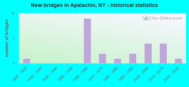
- New bridges - historical statistics
- 11920-1929
- 91960-1969
- 21970-1979
- 11980-1989
- 21990-1999
- 42000-2009
- 42010-2019
- 12020-2022

- Reconstructed bridges - Historical Statistics
- 11990-1999
- 22000-2009
- 12010-2019


- Bridge Condition - Deck
- 18.8%Excellent
- 12.5%Very good
- 37.5%Good
- 6.3%Satisfactory
- 25.0%Fair

- Bridge Condition - Superstructure
- 29.4%Excellent
- 11.8%Very good
- 41.2%Good
- 17.6%Satisfactory

- Bridge Condition - Substructure
- 17.6%Excellent
- 11.8%Very good
- 47.1%Good
- 11.8%Satisfactory
- 11.8%Fair

- Bridge Condition - Channel
- 18.8%Very good
- 25.0%Good
- 25.0%Satisfactory
- 31.3%Fair

- Bridge Condition - Culverts
- 33.3%Very good
- 33.3%Satisfactory
- 33.3%Poor
Find on map >> Show street view
Structure Number: 101425, Location: SE END OF CAMPVILLE (Lat: 42.089147, Lng: -76.149294), Route carried "on" structure: State highway 17C, Year Built: 2016, Status: Open, Structure Length: 1.25m (4.10ft), Average Daily Traffic: 5,441 (year 2020), Truck Traffic: 6%, Average Future Daily Traffic: 6,609 (year 2040), Design Load: HL 93, Features Intersected: CAMPVILLE CREEK
Minimum Vertical Clearance: 30+ m (98+ ft), Kilometerpoint: 41.142, Lanes on structure: 2, Base Highway Network: Yes, Owner: State Highway Agency, Approaching Roadway Width: 10.6m (34.8ft), Skew: 3 degrees, Material/Design: Prestressed concrete, Design/Construction: Box Beam or Girders - Multiple, Number Of Spans In Main Unit: 1, Length of Maximum Span: 12.2m (40.0ft), Curb-To-Curb Width: 10.6m (34.8ft), Out-to-Out Width: 11.6m (38.1ft)
Condition: Deck: Excellent, Superstructure: Excellent, Substructure: Excellent, Channel: Very good, Operating Rating: 94.3 metric tons, Method Used To Determine Operating Rating: Load Factor (LF), Inventory Rating: 43.5 metric tons, Method Used To Determine Inventory Rating: Load Factor (LF), Structural Evaluation: Superior to present desirable criteria, Deck Geometry: Meets minimum limits, Waterway Adequacy: Equal to present desirable criteria, Approach Roadway Alignment: Equal to present desirable criteria, Length Of Structure Improvement: 1.24m (4.07ft), Designated Inspection Frequency: Every 24 months, Inspection Date: November 2020, Bridge Improvement Cost: $436,000, Roadway Improvement Cost: $256,000, Total Project Cost: $692,000 ( Estimate for 2021), Deck Structure Type: Concrete Cast-file-Place, Wearing Surface/Protective System: Wearing Surface: Integral Concrete
Find on map >> Show street view
Structure Number: 1054731, Location: 3.8 MI NW OF APALACHIN (Lat: 42.081494, Lng: -76.202828), Route carried "on" structure: State highway 17, Year Built: 1968, Status: Open, Structure Length: 3.26m (10.70ft), Average Daily Traffic: 10,561 (year 2009), Truck Traffic: 20%, Average Future Daily Traffic: 12,238 (year 2040), Design Load: HS 20+Mod, Features Intersected: MARSHLAND ROAD
Minimum Vertical Clearance: 30+ m (98+ ft), Kilometerpoint: 36.170, Lanes on structure: 2, Lanes under structure: 2, Base Highway Network: Yes, Owner: State Highway Agency, Approaching Roadway Width: 11.9m (39.0ft), Material/Design: Steel, Design/Construction: Stringer/Multi-beam, Number Of Spans In Main Unit: 1, Length of Maximum Span: 31.3m (102.7ft), Curb-To-Curb Width: 11.9m (39.0ft), Out-to-Out Width: 13.0m (42.7ft)
Condition: Deck: Fair, Superstructure: Good, Substructure: Good, Operating Rating: 87.1 metric tons, Method Used To Determine Operating Rating: Load Factor (LF), Inventory Rating: 51.7 metric tons, Method Used To Determine Inventory Rating: Load Factor (LF), Structural Evaluation: Better than present minimum criteria, Deck Geometry: Equal to present minimum criteria, Underclear: Somewhat better than minimum adequacy, Approach Roadway Alignment: Equal to present desirable criteria, Length Of Structure Improvement: 3.26m (10.70ft), Designated Inspection Frequency: Every 24 months, Inspection Date: August 2020, Bridge Improvement Cost: $1,105,000, Roadway Improvement Cost: $647,000, Total Project Cost: $1,752,000 ( Estimate for 2021), Deck Structure Type: Concrete Cast-file-Place, Wearing Surface/Protective System: Wearing Surface: Monolithic Concrete
Find on map >> Show street view
Structure Number: 1054732, Location: 3.8 MI NW OF APALACHIN (Lat: 42.081211, Lng: -76.202711), Route carried "on" structure: State highway 17, Year Built: 1968, Status: Open, Structure Length: 3.05m (10.01ft), Average Daily Traffic: 10,561 (year 2009), Truck Traffic: 20%, Average Future Daily Traffic: 12,238 (year 2040), Design Load: HS 20+Mod, Features Intersected: MARSHLAND ROAD
Minimum Vertical Clearance: 30+ m (98+ ft), Kilometerpoint: 36.170, Lanes on structure: 2, Lanes under structure: 2, Base Highway Network: Yes, Owner: State Highway Agency, Approaching Roadway Width: 11.9m (39.0ft), Material/Design: Steel, Design/Construction: Stringer/Multi-beam, Number Of Spans In Main Unit: 1, Length of Maximum Span: 29.2m (95.8ft), Curb-To-Curb Width: 11.9m (39.0ft), Out-to-Out Width: 13.0m (42.7ft)
Condition: Deck: Fair, Superstructure: Good, Substructure: Good, Operating Rating: 66.2 metric tons, Method Used To Determine Operating Rating: Load Factor (LF), Inventory Rating: 39.0 metric tons, Method Used To Determine Inventory Rating: Load Factor (LF), Structural Evaluation: Better than present minimum criteria, Deck Geometry: Equal to present minimum criteria, Underclear: Meets minimum limits, Approach Roadway Alignment: Equal to present desirable criteria, Length Of Structure Improvement: 3.04m (9.97ft), Designated Inspection Frequency: Every 24 months, Inspection Date: August 2020, Bridge Improvement Cost: $1,034,000, Roadway Improvement Cost: $606,000, Total Project Cost: $1,640,000 ( Estimate for 2021), Deck Structure Type: Concrete Cast-file-Place, Wearing Surface/Protective System: Wearing Surface: Monolithic Concrete
Find on map >> Show street view
Structure Number: 1054751, Location: JCT SH 17 & APALACHIN CRE (Lat: 42.063097, Lng: -76.143731), Route carried "on" structure: State highway 17, Year Built: 1966, Status: Open, Structure Length: 4.24m (13.91ft), Average Daily Traffic: 12,463 (year 2011), Truck Traffic: 18%, Average Future Daily Traffic: 14,442 (year 2040), Design Load: HS 20+Mod, Features Intersected: APALACHIN CREEK
Minimum Vertical Clearance: 30+ m (98+ ft), Kilometerpoint: 42.622, Lanes on structure: 2, Base Highway Network: Yes, Owner: State Highway Agency, Approaching Roadway Width: 12.2m (40.0ft), Material/Design: Steel, Design/Construction: Stringer/Multi-beam, Number Of Spans In Main Unit: 2, Length of Maximum Span: 20.4m (66.9ft), Curb-To-Curb Width: 11.9m (39.0ft), Out-to-Out Width: 13.0m (42.7ft)
Condition: Deck: Fair, Superstructure: Satisfactory, Substructure: Fair, Channel: Satisfactory, Operating Rating: 52.6 metric tons, Method Used To Determine Operating Rating: Load Factor (LF), Inventory Rating: 31.8 metric tons, Method Used To Determine Inventory Rating: Load Factor (LF), Structural Evaluation: Somewhat better than minimum adequacy, Deck Geometry: Equal to present minimum criteria, Waterway Adequacy: Meets minimum limits, Approach Roadway Alignment: Equal to present desirable criteria, Length Of Structure Improvement: 4.23m (13.88ft), Designated Inspection Frequency: Every 24 months, Inspection Date: September 2020, Bridge Improvement Cost: $1,246,000, Roadway Improvement Cost: $730,000, Total Project Cost: $1,975,000 ( Estimate for 2021), Deck Structure Type: Concrete Cast-file-Place, Wearing Surface/Protective System: Wearing Surface: Monolithic Concrete
Find on map >> Show street view
Structure Number: 1054752, Location: JCT SH 17 & APALACHIN CRE (Lat: 42.062981, Lng: -76.143994), Route carried "on" structure: State highway 17, Year Built: 1966, Status: Open, Structure Length: 4.24m (13.91ft), Average Daily Traffic: 12,463 (year 2011), Truck Traffic: 18%, Average Future Daily Traffic: 14,442 (year 2040), Design Load: HS 20+Mod, Features Intersected: APALACHIN CREEK
Minimum Vertical Clearance: 30+ m (98+ ft), Kilometerpoint: 42.622, Lanes on structure: 3, Base Highway Network: Yes, Owner: State Highway Agency, Approaching Roadway Width: 15.2m (49.9ft), Material/Design: Steel, Design/Construction: Stringer/Multi-beam, Number Of Spans In Main Unit: 2, Length of Maximum Span: 20.4m (66.9ft), Curb-To-Curb Width: 12.6m (41.3ft), Out-to-Out Width: 14.0m (45.9ft)
Condition: Deck: Fair, Superstructure: Satisfactory, Substructure: Fair, Channel: Fair, Operating Rating: 51.7 metric tons, Method Used To Determine Operating Rating: Load Factor (LF), Inventory Rating: 30.8 metric tons, Method Used To Determine Inventory Rating: Load Factor (LF), Structural Evaluation: Somewhat better than minimum adequacy, Deck Geometry: High priority of replacement, Waterway Adequacy: Meets minimum limits, Approach Roadway Alignment: Equal to present desirable criteria, Length Of Structure Improvement: 4.23m (13.88ft), Designated Inspection Frequency: Every 24 months, Inspection Date: September 2020, Bridge Improvement Cost: $1,342,000, Roadway Improvement Cost: $786,000, Total Project Cost: $2,129,000 ( Estimate for 2021), Deck Structure Type: Concrete Cast-file-Place, Wearing Surface/Protective System: Wearing Surface: Monolithic Concrete
Find on map >> Show street view
Structure Number: 105476, Location: 1.5 MI NW OF APALACHIN (Lat: 42.083931, Lng: -76.161411), Route carried "on" structure: Other road , Year Built: 1968, Status: Open, Structure Length: 6.58m (21.59ft), Average Daily Traffic: 697 (year 2020), Truck Traffic: 2%, Average Future Daily Traffic: 862 (year 2040), Design Load: HS 20+Mod, Features Intersected: 17 17 65063234, RTE 17, Facility Carried by Structure: MARSHLAND ROAD
Minimum Vertical Clearance: 30+ m (98+ ft), Kilometerpoint: 5.084, Lanes on structure: 2, Lanes under structure: 4, Owner: State Highway Agency, Approaching Roadway Width: 8.5m (27.9ft), Material/Design: Steel, Design/Construction: Stringer/Multi-beam, Number Of Spans In Main Unit: 2, Length of Maximum Span: 32.3m (106.0ft), Curb-To-Curb Width: 7.3m (24.0ft), Out-to-Out Width: 8.8m (28.9ft)
Condition: Deck: Satisfactory, Superstructure: Good, Substructure: Satisfactory, Operating Rating: 68.0 metric tons, Method Used To Determine Operating Rating: Load Factor (LF), Inventory Rating: 40.8 metric tons, Method Used To Determine Inventory Rating: Load Factor (LF), Structural Evaluation: Equal to present minimum criteria, Deck Geometry: Meets minimum limits, Underclear: Meets minimum limits, Approach Roadway Alignment: Equal to present desirable criteria, Length Of Structure Improvement: 6.58m (21.59ft), Designated Inspection Frequency: Every 24 months, Inspection Date: June 2020, Bridge Improvement Cost: $1,291,000, Roadway Improvement Cost: $756,000, Total Project Cost: $2,048,000 ( Estimate for 2021), Deck Structure Type: Concrete Cast-file-Place, Wearing Surface/Protective System: Wearing Surface: Integral Concrete
Find on map >> Show street view
Structure Number: 105477, Location: AT S.H.17 EXIT 66 (Lat: 42.065756, Lng: -76.145850), Route carried "on" structure: Other road 962J, Year Built: 2000, Status: Open, Structure Length: 6.16m (20.21ft), Average Daily Traffic: 8,716 (year 2017), Truck Traffic: 3%, Average Future Daily Traffic: 10,588 (year 2040), Design Load: HS 25 or greater, Features Intersected: 17 17 65063249WB, RTE 1
Minimum Vertical Clearance: 30+ m (98+ ft), Kilometerpoint: 0.129, Lanes on structure: 3, Lanes under structure: 4, Base Highway Network: Yes, Owner: State Highway Agency, Approaching Roadway Width: 15.5m (50.9ft), Material/Design: Steel continuous, Design/Construction: Stringer/Multi-beam, Number Of Spans In Main Unit: 2, Length of Maximum Span: 30.3m (99.4ft), Curb-To-Curb Width: 15.6m (51.2ft), Out-to-Out Width: 16.4m (53.8ft)
Condition: Deck: Good, Superstructure: Good, Substructure: Very good, Operating Rating: 82.6 metric tons, Method Used To Determine Operating Rating: Load Factor (LF), Inventory Rating: 49.9 metric tons, Method Used To Determine Inventory Rating: Load Factor (LF), Structural Evaluation: Better than present minimum criteria, Deck Geometry: Equal to present minimum criteria, Underclear: Somewhat better than minimum adequacy, Approach Roadway Alignment: Equal to present desirable criteria, Length Of Structure Improvement: 6.15m (20.18ft), Designated Inspection Frequency: Every 24 months, Inspection Date: April 2021, Bridge Improvement Cost: $2,294,000, Roadway Improvement Cost: $1,343,000, Total Project Cost: $3,637,000 ( Estimate for 2021), Deck Structure Type: Concrete Cast-file-Place, Wearing Surface/Protective System: Wearing Surface: Monolithic Concrete, Deck Protection: Epoxy Coated Reinforcing
Find on map >> Show street view
Structure Number: 107757, Location: .1 MI NE EXIT 66 OF SH17 (Lat: 42.066636, Lng: -76.143933), Route carried "on" structure: Other road 962J, Year Built: 2001, Status: Open, Structure Length: 23.35m (76.61ft), Average Daily Traffic: 5,074 (year 2020), Truck Traffic: 6%, Average Future Daily Traffic: 6,163 (year 2040), Design Load: HS 25 or greater, Features Intersected: NORFOLK SOUTHERN RAILROA
Minimum Vertical Clearance: 30+ m (98+ ft), Kilometerpoint: 0.338, Lanes on structure: 2, Base Highway Network: Yes, Owner: State Highway Agency, Approaching Roadway Width: 15.2m (49.9ft), Skew: 20 degrees, Material/Design: Steel continuous, Design/Construction: Stringer/Multi-beam, Number Of Spans In Main Unit: 5, Length of Maximum Span: 58.0m (190.3ft), Curb-To-Curb Width: 15.1m (49.5ft), Out-to-Out Width: 16.4m (53.8ft)
Condition: Deck: Good, Superstructure: Very good, Substructure: Good, Channel: Very good, Operating Rating: 80.7 metric tons, Method Used To Determine Operating Rating: Load Factor (LF), Inventory Rating: 48.1 metric tons, Method Used To Determine Inventory Rating: Load Factor (LF), Structural Evaluation: Better than present minimum criteria, Deck Geometry: Superior to present desirable criteria, Underclear: Equal to present minimum criteria, Waterway Adequacy: Equal to present minimum criteria, Approach Roadway Alignment: Equal to present desirable criteria, Length Of Structure Improvement: 23.34m (76.57ft), Designated Inspection Frequency: Every 24 months, Inspection Date: November 2021, Bridge Improvement Cost: $7,991,000, Roadway Improvement Cost: $4,680,000, Total Project Cost: $12,670,000 ( Estimate for 2021), Deck Structure Type: Concrete Cast-file-Place, Wearing Surface/Protective System: Wearing Surface: Monolithic Concrete, Deck Protection: Epoxy Coated Reinforcing
Find on map >> Show street view
Structure Number: 109098, Location: 0.8 MI SE OF APALACHIN (Lat: 42.062603, Lng: -76.145308), Route carried "on" structure: Alternate State highway 434, Year Built: 1991, Status: Open, Structure Length: 4.02m (13.19ft), Average Daily Traffic: 7,839 (year 2017), Truck Traffic: 4%, Average Future Daily Traffic: 9,522 (year 2040), Design Load: HS 20, Features Intersected: APALACHIN CREEK
Minimum Vertical Clearance: 30+ m (98+ ft), Kilometerpoint: 12.003, Lanes on structure: 2, Base Highway Network: Yes, Owner: State Highway Agency, Approaching Roadway Width: 13.4m (44.0ft), Skew: 2 degrees, Material/Design: Steel, Design/Construction: Stringer/Multi-beam, Number Of Spans In Main Unit: 1, Length of Maximum Span: 39.9m (130.9ft), Curb-To-Curb Width: 13.4m (44.0ft), Out-to-Out Width: 14.0m (45.9ft)
Condition: Deck: Good, Superstructure: Good, Substructure: Very good, Channel: Good, Inventory Rating: 68.0 metric tons, Method Used To Determine Inventory Rating: Load Factor (LF), Structural Evaluation: Better than present minimum criteria, Deck Geometry: Equal to present minimum criteria, Waterway Adequacy: Equal to present minimum criteria, Approach Roadway Alignment: Equal to present desirable criteria, Length Of Structure Improvement: 4.02m (13.19ft), Designated Inspection Frequency: Every 24 months, Inspection Date: September 2020, Bridge Improvement Cost: $1,367,000, Roadway Improvement Cost: $801,000, Total Project Cost: $2,168,000 ( Estimate for 2021), Deck Structure Type: Concrete Cast-file-Place, Wearing Surface/Protective System: Wearing Surface: Integral Concrete, Deck Protection: Epoxy Coated Reinforcing
Find on map >> Show street view
Structure Number: 22187, Location: 3.6 MI NORTH OF APALACHIN (Lat: 42.118994, Lng: -76.149181), Route carried "on" structure: Other road , Year Built: 2013, Status: Open, Structure Length: 1.01m (3.31ft), Average Daily Traffic: 542 (year 2016), Truck Traffic: 3%, Average Future Daily Traffic: 759 (year 2036), Features Intersected: FOSTER CREEK, Facility Carried by Structure: FOSTER VALLEY RD
Minimum Vertical Clearance: 30+ m (98+ ft), Kilometerpoint: 1.046, Lanes on structure: 2, Owner: Town or Township Highway Agency, Approaching Roadway Width: 6.7m (22.0ft), Skew: 3 degrees, Material/Design: Aluminum, Iron, Design/Construction: Culvert, Number Of Spans In Main Unit: 1, Length of Maximum Span: 9.8m (32.2ft)
Condition: Channel: Satisfactory, Culverts: Very good, Operating Rating: 79.5 metric tons, Method Used To Determine Operating Rating: Field evaluation and documented engineering judgment, Inventory Rating: 40.8 metric tons, Method Used To Determine Inventory Rating: Field evaluation and documented engineering judgment, Structural Evaluation: Equal to present desirable criteria, Waterway Adequacy: Equal to present minimum criteria, Approach Roadway Alignment: Equal to present desirable criteria, Length Of Structure Improvement: 1.00m (3.28ft), Designated Inspection Frequency: Every 24 months, Inspection Date: July 2021, Bridge Improvement Cost: $119,000, Roadway Improvement Cost: $70,000, Total Project Cost: $189,000 ( Estimate for 2021)
Find on map >> Show street view
Structure Number: 221874, Location: 1.6 MI SW OF APALACHIN (Lat: 42.037633, Lng: -76.174408), Route carried "on" structure: Other road , Year Built: 1978, Status: Posted for load, Structure Length: 0.79m (2.59ft), Average Daily Traffic: 347 (year 2016), Truck Traffic: 4%, Average Future Daily Traffic: 486 (year 2036), Features Intersected: LONG CREEK, Facility Carried by Structure: LONG CREEK ROAD
Minimum Vertical Clearance: 30+ m (98+ ft), Kilometerpoint: 4.103, Lanes on structure: 2, Owner: Town or Township Highway Agency, Approaching Roadway Width: 6.7m (22.0ft), Skew: 2 degrees, Material/Design: Steel, Design/Construction: Culvert, Number Of Spans In Main Unit: 1, Length of Maximum Span: 7.3m (24.0ft)
Condition: Channel: Fair, Culverts: Poor, Operating Rating: 14.5 metric tons, Method Used To Determine Operating Rating: Field evaluation and documented engineering judgment, Inventory Rating: 14.5 metric tons, Method Used To Determine Inventory Rating: Field evaluation and documented engineering judgment, Structural Evaluation: Meets minimum limits, Waterway Adequacy: Meets minimum limits, Approach Roadway Alignment: Equal to present minimum criteria, Bridge Posting: Required (Relationship of Operating Rating to Maximum Legal Load: > 39.9% below), Length Of Structure Improvement: 0.79m (2.59ft), Designated Inspection Frequency: Every 12 months, Inspection Date: April 2021, Bridge Improvement Cost: $94,000, Roadway Improvement Cost: $55,000, Total Project Cost: $149,000 ( Estimate for 2021)
Find on map >> Show street view
Structure Number: 221875, Location: 1.4 MI SW OF APALACHIN (Lat: 42.039292, Lng: -76.172058), Route carried "on" structure: Other road , Year Built: 2020, Status: Open, Structure Length: 1.10m (3.61ft), Average Daily Traffic: 347 (year 2016), Truck Traffic: 4%, Average Future Daily Traffic: 486 (year 2036), Design Load: HL 93, Features Intersected: LONG CREEK, Facility Carried by Structure: LONG CREEK ROAD
Minimum Vertical Clearance: 32.69m (107.25ft), Kilometerpoint: 4.360, Lanes on structure: 2, Owner: Town or Township Highway Agency, Approaching Roadway Width: 8.5m (27.9ft), Skew: 3 degrees, Material/Design: Concrete, Design/Construction: Frame, Number Of Spans In Main Unit: 1, Length of Maximum Span: 10.4m (34.1ft), Curb-To-Curb Width: 8.4m (27.6ft), Out-to-Out Width: 9.9m (32.5ft)
Condition: Deck: Excellent, Superstructure: Excellent, Substructure: Satisfactory, Channel: Satisfactory, Operating Rating: 46.7 metric tons, Method Used To Determine Operating Rating: Load and Resistance Factor Rating (LRFR) rating reported by rating factor(RF) method using HL-93 loadings, Inventory Rating: 36.0 metric tons, Method Used To Determine Inventory Rating: Load and Resistance Factor Rating (LRFR) rating reported by rating factor(RF) method using HL-93 loadings, Structural Evaluation: Equal to present minimum criteria, Deck Geometry: Somewhat better than minimum adequacy, Waterway Adequacy: Meets minimum limits, Approach Roadway Alignment: Equal to present desirable criteria, Length Of Structure Improvement: 1.09m (3.58ft), Designated Inspection Frequency: Every 24 months, Inspection Date: December 2020, Bridge Improvement Cost: $464,000, Roadway Improvement Cost: $272,000, Total Project Cost: $736,000 ( Estimate for 2021)
Find on map >> Show street view
Structure Number: 221876, Location: 0.6 MI SE OF APALACHIN (Lat: 42.062292, Lng: -76.148814), Route carried "on" structure: Other road , Year Built: 1929, Year Reconstructed: 2002, Status: Open, Structure Length: 4.21m (13.81ft), Average Daily Traffic: 957 (year 2017), Truck Traffic: 4%, Average Future Daily Traffic: 1,184 (year 2040), Features Intersected: APALACHIN CREEK, Facility Carried by Structure: MAIN STREET
Minimum Vertical Clearance: 4.54m (14.90ft), Kilometerpoint: 1.963, Lanes on structure: 2, Owner: County Highway Agency, Approaching Roadway Width: 7.6m (24.9ft), Skew: 2 degrees, Material/Design: Steel, Design/Construction: Truss - Thru, Number Of Spans In Main Unit: 1, Length of Maximum Span: 39.6m (129.9ft), Curb-To-Curb Width: 8.4m (27.6ft), Out-to-Out Width: 9.8m (32.2ft)
Condition: Deck: Good, Superstructure: Satisfactory, Substructure: Good, Channel: Fair, Operating Rating: 59.9 metric tons, Method Used To Determine Operating Rating: Load Factor (LF), Inventory Rating: 35.4 metric tons, Method Used To Determine Inventory Rating: Load Factor (LF), Structural Evaluation: Equal to present minimum criteria, Deck Geometry: High priority of corrective action, Waterway Adequacy: Meets minimum limits, Approach Roadway Alignment: Equal to present desirable criteria, Length Of Structure Improvement: 4.20m (13.78ft), Designated Inspection Frequency: Every 24 months, Critical Feature Inspection Frequency: Every 24 months, Underwater Inspection Frequency: Every 60 months, Inspection Date: September 2020, Critical Feature Inspection Date: September 2020, Underwater Inspection Date: August 2019, Bridge Improvement Cost: $3,730,000, Roadway Improvement Cost: $2,184,000, Total Project Cost: $5,914,000 ( Estimate for 2021), Deck Structure Type: Concrete Cast-file-Place, Wearing Surface/Protective System: Wearing Surface: Integral Concrete
Find on map >> Show street view
Structure Number: 333535, Location: 4.0 MI E OF OWEGO (Lat: 42.107486, Lng: -76.189678), Route carried "on" structure: County highway , Year Built: 2004, Status: Open, Structure Length: 2.80m (9.19ft), Average Daily Traffic: 1,880 (year 2020), Truck Traffic: 4%, Average Future Daily Traffic: 2,283 (year 2040), Design Load: HS 25 or greater, Features Intersected: LITTLE NANTICOKE CREEK, Facility Carried by Structure: DAY HOLLOW ROAD
Minimum Vertical Clearance: 30+ m (98+ ft), Kilometerpoint: 3.186, Lanes on structure: 2, Owner: County Highway Agency, Approaching Roadway Width: 9.1m (29.9ft), Skew: 3 degrees, Material/Design: Prestressed concrete, Design/Construction: Box Beam or Girders - Multiple, Number Of Spans In Main Unit: 1, Length of Maximum Span: 27.1m (88.9ft), Curb-To-Curb Width: 9.6m (31.5ft), Out-to-Out Width: 10.7m (35.1ft)
Condition: Deck: Good, Superstructure: Good, Substructure: Good, Channel: Good, Inventory Rating: 65.3 metric tons, Method Used To Determine Inventory Rating: Load Factor (LF), Structural Evaluation: Better than present minimum criteria, Deck Geometry: Somewhat better than minimum adequacy, Waterway Adequacy: Equal to present minimum criteria, Approach Roadway Alignment: Equal to present desirable criteria, Length Of Structure Improvement: 2.80m (9.19ft), Designated Inspection Frequency: Every 24 months, Inspection Date: October 2020, Bridge Improvement Cost: $797,000, Roadway Improvement Cost: $467,000, Total Project Cost: $1,263,000 ( Estimate for 2021), Deck Structure Type: Concrete Cast-file-Place, Wearing Surface/Protective System: Wearing Surface: Integral Concrete, Deck Protection: Epoxy Coated Reinforcing
Find on map >> Show street view
Structure Number: 333536, Location: 5.6 MI E OF OWEGO (Lat: 42.109050, Lng: -76.161264), Route carried "on" structure: County highway , Year Built: 1982, Year Reconstructed: 2019, Status: Open, Structure Length: 1.86m (6.10ft), Average Daily Traffic: 1,880 (year 2020), Truck Traffic: 4%, Average Future Daily Traffic: 2,283 (year 2040), Design Load: HS 20, Features Intersected: FOSTER CREEK, Facility Carried by Structure: DAY HOLLOW ROAD
Minimum Vertical Clearance: 30+ m (98+ ft), Kilometerpoint: 5.535, Lanes on structure: 2, Owner: County Highway Agency, Approaching Roadway Width: 12.2m (40.0ft), Skew: 2 degrees, Material/Design: Steel, Design/Construction: Stringer/Multi-beam, Number Of Spans In Main Unit: 1, Length of Maximum Span: 18.0m (59.1ft), Curb-To-Curb Width: 12.2m (40.0ft), Out-to-Out Width: 13.2m (43.3ft)
Condition: Deck: Excellent, Superstructure: Excellent, Substructure: Excellent, Channel: Good, Operating Rating: 56.7 metric tons, Method Used To Determine Operating Rating: Load and Resistance Factor Rating (LRFR) rating reported by rating factor(RF) method using HL-93 loadings, Inventory Rating: 43.7 metric tons, Method Used To Determine Inventory Rating: Load and Resistance Factor Rating (LRFR) rating reported by rating factor(RF) method using HL-93 loadings, Structural Evaluation: Superior to present desirable criteria, Deck Geometry: Better than present minimum criteria, Waterway Adequacy: Somewhat better than minimum adequacy, Approach Roadway Alignment: Equal to present desirable criteria, Length Of Structure Improvement: 1.85m (6.07ft), Designated Inspection Frequency: Every 24 months, Inspection Date: October 2021, Bridge Improvement Cost: $812,000, Roadway Improvement Cost: $475,000, Total Project Cost: $1,287,000 ( Estimate for 2021), Deck Structure Type: Concrete Cast-file-Place, Wearing Surface/Protective System: Wearing Surface: Integral Concrete, Deck Protection: Epoxy Coated Reinforcing
Find on map >> Show street view
Structure Number: 333537, Location: 4.3 MI NE OF OWEGO (Lat: 42.113581, Lng: -76.182439), Route carried "on" structure: County highway , Year Built: 1963, Year Reconstructed: 2012, Status: Open, Structure Length: 2.80m (9.19ft), Average Daily Traffic: 1,166 (year 2019), Truck Traffic: 14%, Average Future Daily Traffic: 1,632 (year 2039), Design Load: HL 93, Features Intersected: LITTLE NANTICOKE CREEK, Facility Carried by Structure: GASKILL ROAD
Minimum Vertical Clearance: 30+ m (98+ ft), Kilometerpoint: 0.724, Lanes on structure: 2, Owner: County Highway Agency, Approaching Roadway Width: 8.5m (27.9ft), Skew: 6 degrees, Material/Design: Steel, Design/Construction: Stringer/Multi-beam, Number Of Spans In Main Unit: 1, Length of Maximum Span: 25.9m (85.0ft), Curb-To-Curb Width: 8.4m (27.6ft), Out-to-Out Width: 9.4m (30.8ft)
Condition: Deck: Good, Superstructure: Good, Substructure: Good, Channel: Fair, Operating Rating: 67.1 metric tons, Method Used To Determine Operating Rating: Load Factor (LF), Inventory Rating: 39.9 metric tons, Method Used To Determine Inventory Rating: Load Factor (LF), Structural Evaluation: Better than present minimum criteria, Deck Geometry: Meets minimum limits, Waterway Adequacy: Somewhat better than minimum adequacy, Approach Roadway Alignment: Equal to present desirable criteria, Length Of Structure Improvement: 2.80m (9.19ft), Designated Inspection Frequency: Every 24 months, Inspection Date: October 2020, Bridge Improvement Cost: $957,000, Roadway Improvement Cost: $560,000, Total Project Cost: $1,517,000 ( Estimate for 2021), Deck Structure Type: Concrete Cast-file-Place, Wearing Surface/Protective System: Wearing Surface: Integral Concrete, Deck Protection: Epoxy Coated Reinforcing
Find on map >> Show street view
Structure Number: 333538, Location: 4.6 MILES EAST OF OWEGO (Lat: 42.123889, Lng: -76.180725), Route carried "on" structure: County highway , Year Built: 1999, Status: Open, Structure Length: 0.91m (2.99ft), Average Daily Traffic: 1,166 (year 2019), Truck Traffic: 14%, Average Future Daily Traffic: 1,632 (year 2039), Design Load: HS 25 or greater, Features Intersected: LIT NANTICOKE CRK, Facility Carried by Structure: GASKILL ROAD
Minimum Vertical Clearance: 30+ m (98+ ft), Kilometerpoint: 1.995, Lanes on structure: 2, Owner: County Highway Agency, Approaching Roadway Width: 7.3m (24.0ft), Skew: 4 degrees, Material/Design: Concrete, Design/Construction: Culvert, Number Of Spans In Main Unit: 1, Length of Maximum Span: 8.8m (28.9ft)
Condition: Channel: Satisfactory, Culverts: Satisfactory, Operating Rating: 63.5 metric tons, Method Used To Determine Operating Rating: Load Factor (LF), Inventory Rating: 38.1 metric tons, Method Used To Determine Inventory Rating: Load Factor (LF), Structural Evaluation: Equal to present minimum criteria, Waterway Adequacy: Somewhat better than minimum adequacy, Approach Roadway Alignment: Equal to present desirable criteria, Length Of Structure Improvement: 0.91m (2.99ft), Designated Inspection Frequency: Every 24 months, Inspection Date: May 2021, Bridge Improvement Cost: $304,000, Roadway Improvement Cost: $178,000, Total Project Cost: $481,000 ( Estimate for 2021), Wearing Surface/Protective System: Wearing Surface: Bituminous, Membrane: Other
Find on map >> Show street view
Structure Number: 333539, Location: 5.1 MI NE OF OWEGO (Lat: 42.130033, Lng: -76.183531), Route carried "on" structure: County highway , Year Built: 2013, Status: Open, Structure Length: 1.10m (3.61ft), Average Daily Traffic: 756 (year 2019), Truck Traffic: 17%, Average Future Daily Traffic: 1,058 (year 2039), Design Load: HL 93, Features Intersected: LITT NANTICOKE CK, Facility Carried by Structure: GASKILL ROAD
Minimum Vertical Clearance: 30+ m (98+ ft), Kilometerpoint: 2.880, Lanes on structure: 2, Owner: County Highway Agency, Approaching Roadway Width: 6.7m (22.0ft), Material/Design: Concrete, Design/Construction: Frame, Number Of Spans In Main Unit: 1, Length of Maximum Span: 10.7m (35.1ft), Curb-To-Curb Width: 7.3m (24.0ft), Out-to-Out Width: 8.4m (27.6ft)
Condition: Superstructure: Excellent, Substructure: Good, Channel: Fair, Operating Rating: 45.4 metric tons, Method Used To Determine Operating Rating: Load and Resistance Factor Rating (LRFR) rating reported by rating factor(RF) method using HL-93 loadings, Inventory Rating: 38.9 metric tons, Method Used To Determine Inventory Rating: Load and Resistance Factor Rating (LRFR) rating reported by rating factor(RF) method using HL-93 loadings, Structural Evaluation: Better than present minimum criteria, Deck Geometry: Meets minimum limits, Waterway Adequacy: Equal to present minimum criteria, Approach Roadway Alignment: Equal to present desirable criteria, Length Of Structure Improvement: 1.09m (3.58ft), Designated Inspection Frequency: Every 24 months, Inspection Date: October 2021, Bridge Improvement Cost: $163,000, Roadway Improvement Cost: $95,000, Total Project Cost: $258,000 ( Estimate for 2021), Wearing Surface/Protective System: Wearing Surface: Bituminous
Find on map >> Show street view
Structure Number: 333549, Location: 1.3 MI SW OF APALACHIN (Lat: 42.053272, Lng: -76.167492), Route carried "on" structure: County highway , Year Built: 1971, Year Reconstructed: 2014, Status: Open, Structure Length: 1.65m (5.41ft), Average Daily Traffic: 4,159 (year 2020), Truck Traffic: 7%, Average Future Daily Traffic: 5,052 (year 2040), Design Load: HS 20, Features Intersected: DEERLICK CREEK, Facility Carried by Structure: PENNSYLVANIA AVE
Minimum Vertical Clearance: 30+ m (98+ ft), Kilometerpoint: 6.838, Lanes on structure: 2, Owner: County Highway Agency, Approaching Roadway Width: 7.3m (24.0ft), Skew: 3 degrees, Material/Design: Steel, Design/Construction: Stringer/Multi-beam, Number Of Spans In Main Unit: 1, Length of Maximum Span: 14.6m (47.9ft), Curb-To-Curb Width: 9.7m (31.8ft), Out-to-Out Width: 10.7m (35.1ft)
Condition: Deck: Very good, Superstructure: Very good, Substructure: Good, Channel: Very good, Operating Rating: 83.5 metric tons, Method Used To Determine Operating Rating: Load Factor (LF), Inventory Rating: 49.9 metric tons, Method Used To Determine Inventory Rating: Load Factor (LF), Structural Evaluation: Better than present minimum criteria, Deck Geometry: Meets minimum limits, Waterway Adequacy: Equal to present desirable criteria, Approach Roadway Alignment: Equal to present desirable criteria, Length Of Structure Improvement: 1.64m (5.38ft), Designated Inspection Frequency: Every 24 months, Inspection Date: October 2020, Bridge Improvement Cost: $670,000, Roadway Improvement Cost: $392,000, Total Project Cost: $1,062,000 ( Estimate for 2021), Deck Structure Type: Concrete Cast-file-Place, Wearing Surface/Protective System: Wearing Surface: Monolithic Concrete, Deck Protection: Epoxy Coated Reinforcing
Find on map >> Show street view
Structure Number: 337093, Location: 2.3 mi South of Intersect (Lat: 42.040769, Lng: -76.164650), Route carried "on" structure: County highway , Year Built: 2013, Status: Open, Structure Length: 1.46m (4.79ft), Average Daily Traffic: 3,309 (year 2020), Truck Traffic: 8%, Average Future Daily Traffic: 4,019 (year 2040), Features Intersected: Long Creek, Facility Carried by Structure: COUNTY ROAD 41
Minimum Vertical Clearance: 30+ m (98+ ft), Kilometerpoint: 5.245, Lanes on structure: 2, Owner: County Highway Agency, Approaching Roadway Width: 6.7m (22.0ft), Skew: 1 degrees, Material/Design: Prestressed concrete, Design/Construction: Box Beam or Girders - Multiple, Number Of Spans In Main Unit: 1, Length of Maximum Span: 13.7m (44.9ft), Curb-To-Curb Width: 7.9m (25.9ft), Out-to-Out Width: 9.0m (29.5ft)
Condition: Deck: Very good, Superstructure: Excellent, Substructure: Excellent, Channel: Good, Operating Rating: 68.9 metric tons, Method Used To Determine Operating Rating: Load Factor (LF), Inventory Rating: 41.7 metric tons, Method Used To Determine Inventory Rating: Load Factor (LF), Structural Evaluation: Superior to present desirable criteria, Deck Geometry: High priority of corrective action, Waterway Adequacy: Equal to present minimum criteria, Approach Roadway Alignment: Equal to present desirable criteria, Length Of Structure Improvement: 1.46m (4.79ft), Designated Inspection Frequency: Every 24 months, Inspection Date: October 2021, Bridge Improvement Cost: $370,000, Roadway Improvement Cost: $216,000, Total Project Cost: $586,000 ( Estimate for 2021), Wearing Surface/Protective System: Wearing Surface: Integral Concrete
Find on map >> Show street view
Structure Number: 1054731, Location: 3.8 MI NW OF APALACHIN (Lat: 42.081494, Lng: -76.202828), Route carried "under" structure: Other road , Year Built: 1968, Structure Length: 0. m, Average Daily Traffic: 349 (year 2020), Truck Traffic: 2%, Features Intersected: MARSHLAND ROAD, Facility Carried by Structure: RTE 17
Minimum Vertical Clearance: 4.72m (15.49ft), Kilometerpoint: 0.000, Lanes on structure: 2, Lanes under structure: 2, Material/Design: Steel, Design/Construction: Stringer/Multi-beam, Length of Maximum Span: 31.3m (102.7ft)
Find on map >> Show street view
Structure Number: 1054732, Location: 3.8 MI NW OF APALACHIN (Lat: 42.081211, Lng: -76.202711), Route carried "under" structure: Other road , Year Built: 1968, Structure Length: 0. m, Average Daily Traffic: 907 (year 2013), Truck Traffic: 4%, Features Intersected: MARSHLAND ROAD, Facility Carried by Structure: RTE 17
Minimum Vertical Clearance: 4.39m (14.40ft), Kilometerpoint: 0.000, Lanes on structure: 2, Lanes under structure: 2, Material/Design: Steel, Design/Construction: Stringer/Multi-beam, Length of Maximum Span: 29.2m (95.8ft)
Find on map >> Show street view
Structure Number: 105476, Location: 1.5 MI NW OF APALACHIN (Lat: 42.083931, Lng: -76.161411), Route carried "under" structure: State highway 17, Year Built: 1968, Structure Length: 0. m, Average Daily Traffic: 24,205 (year 1999), Features Intersected: 17 17 65063234, RTE 17, Facility Carried by Structure: MARSHLAND ROAD
Minimum Vertical Clearance: 4.93m (16.17ft), Kilometerpoint: 39.903, Lanes on structure: 2, Lanes under structure: 2, Material/Design: Steel, Design/Construction: Stringer/Multi-beam, Length of Maximum Span: 32.3m (106.0ft)
Find on map >> Show street view
Structure Number: 105477, Location: AT S.H.17 EXIT 66 (Lat: 42.065756, Lng: -76.145850), Route carried "under" structure: State highway 17, Year Built: 2000, Structure Length: 0. m, Average Daily Traffic: 21,162 (year 1998), Features Intersected: 17 17 65063249WB, RTE 1, Facility Carried by Structure: RTE 962J
Minimum Vertical Clearance: 5.16m (16.93ft), Kilometerpoint: 42.301, Lanes on structure: 3, Lanes under structure: 2, Material/Design: Steel continuous, Design/Construction: Stringer/Multi-beam, Length of Maximum Span: 30.3m (99.4ft)