Bridge Statistics for Archbald, Pennsylvania (PA)
Condition, Traffic, Stress, Structural Evaluation, Project Costs
- National Bridge Inventory (NBI) Statistics
- 22Number of bridges
- 141ft / 42.8mTotal length
- $2,254,000Total costs
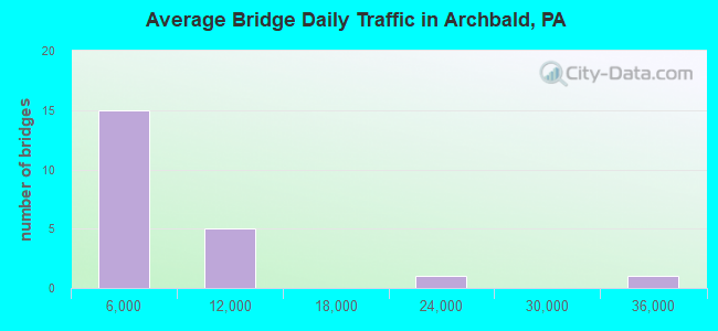
- 111,388Total average daily traffic
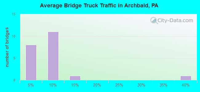
- 16,460Total average daily truck traffic
- National Bridge Inventory (NBI) Registered Bridges for Archbald
- No street view available for this location
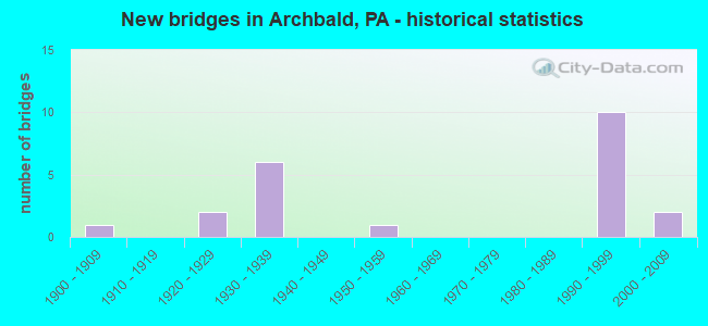
- New bridges - historical statistics
- 11900-1909
- 21920-1929
- 61930-1939
- 11950-1959
- 101990-1999
- 22000-2009
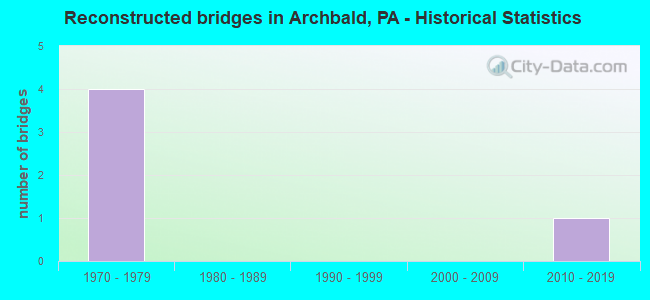
- Reconstructed bridges - Historical Statistics
- 41970-1979
- 01980-1989
- 01990-1999
- 02000-2009
- 12010-2019
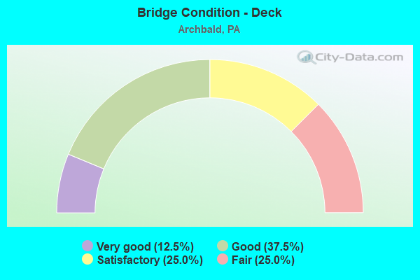
- Bridge Condition - Deck
- 12.5%Very good
- 37.5%Good
- 25.0%Satisfactory
- 25.0%Fair
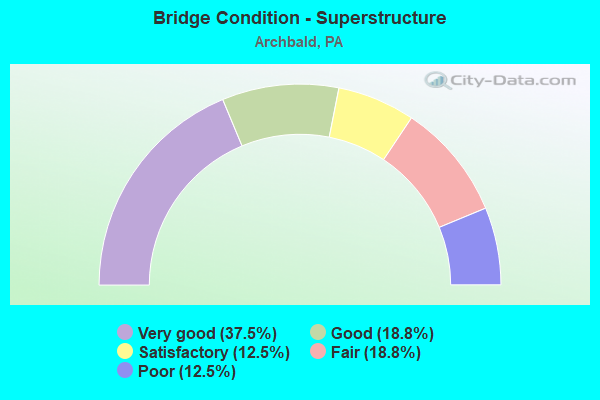
- Bridge Condition - Superstructure
- 37.5%Very good
- 18.8%Good
- 12.5%Satisfactory
- 18.8%Fair
- 12.5%Poor
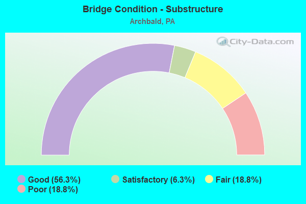
- Bridge Condition - Substructure
- 56.3%Good
- 6.3%Satisfactory
- 18.8%Fair
- 18.8%Poor
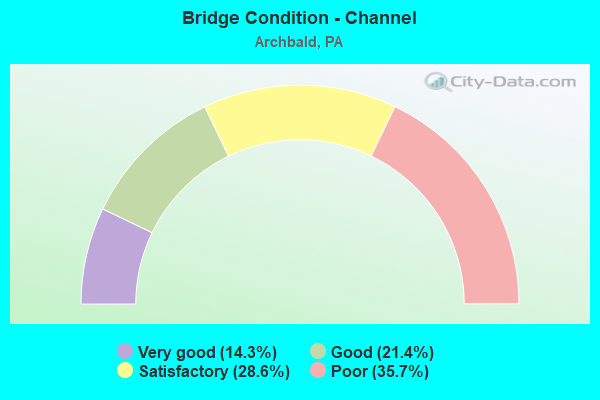
- Bridge Condition - Channel
- 14.3%Very good
- 21.4%Good
- 28.6%Satisfactory
- 35.7%Poor
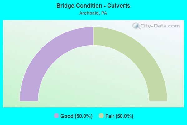
- Bridge Condition - Culverts
- 50.0%Good
- 50.0%Fair
Find on map >> Show street view
Structure Number: 4444, Location: NEAR EARLSTON (Lat: 40.016667, Lng: -78.356667), Route carried "on" structure: Interstate 76, Year Built: 1939, Status: Open, Structure Length: 1.25m (4.10ft), Average Daily Traffic: 33,684 (year 2001), Truck Traffic: 36%, Average Future Daily Traffic: 38,535 (year 2030), Design Load: HS 20, Features Intersected: PA 26 (LR 286)
Minimum Vertical Clearance: 30+ m (98+ ft), Kilometerpoint: 250.510, Lanes on structure: 4, Lanes under structure: 2, Base Highway Network: Yes, Toll: On toll road, Owner: State Toll Authority, Approaching Roadway Width: 23.2m (76.1ft), Skew: 33 degrees, Material/Design: Concrete, Design/Construction: Culvert, Number Of Spans In Main Unit: 1, Length of Maximum Span: 11.0m (36.1ft)
Condition: Culverts: Fair, Operating Rating: 89.8 metric tons, Method Used To Determine Operating Rating: Load Factor (LF), Inventory Rating: 32.7 metric tons, Method Used To Determine Inventory Rating: Load Factor (LF), Structural Evaluation: Somewhat better than minimum adequacy, Underclear: Meets minimum limits, Approach Roadway Alignment: Equal to present desirable criteria, Length Of Structure Improvement: 1.80m (5.91ft), Designated Inspection Frequency: Every 24 months, Inspection Date: September 2020, Bridge Improvement Cost: $30,000, Roadway Improvement Cost: $89,000, Total Project Cost: $406,000
Find on map >> Show street view
Structure Number: 20534, Location: SCOTT TWP .1 M W SR 1017 (Lat: 41.564514, Lng: -75.582131), Route carried "on" structure: State highway 107, Year Built: 1931, Year Reconstructed: 1984, Status: Open, Structure Length: 0.67m (2.20ft), Average Daily Traffic: 2,781 (year 2022), Truck Traffic: 8%, Average Future Daily Traffic: 4,406 (year 2032), Design Load: HS 20, Features Intersected: HEART LAKE CREEK
Minimum Vertical Clearance: 30+ m (98+ ft), Kilometerpoint: 16.785, Lanes on structure: 2, Owner: State Highway Agency, Approaching Roadway Width: 7.6m (24.9ft), Skew: 4 degrees, Material/Design: Concrete, Design/Construction: Slab, Number Of Spans In Main Unit: 1, Length of Maximum Span: 6.1m (20.0ft), Curb-To-Curb Width: 7.7m (25.3ft), Out-to-Out Width: 8.6m (28.2ft)
Condition: Deck: Satisfactory, Superstructure: Satisfactory, Substructure: Fair, Channel: Poor, Operating Rating: 49.0 metric tons, Method Used To Determine Operating Rating: Field evaluation and documented engineering judgment, Inventory Rating: 32.7 metric tons, Method Used To Determine Inventory Rating: Field evaluation and documented engineering judgment, Structural Evaluation: Somewhat better than minimum adequacy, Deck Geometry: High priority of replacement, Waterway Adequacy: Better than present minimum criteria, Approach Roadway Alignment: Equal to present desirable criteria, Length Of Structure Improvement: 0.70m (2.30ft), Designated Inspection Frequency: Every 24 months, Inspection Date: May 2020, Bridge Improvement Cost: $11,000, Roadway Improvement Cost: $100,000, Total Project Cost: $144,000, Wearing Surface/Protective System: Wearing Surface: Bituminous
Find on map >> Show street view
Structure Number: 20537, Location: SCOTT TWP .5M W SR 1006 (Lat: 41.555386, Lng: -75.570997), Route carried "on" structure: State highway 107, Year Built: 1931, Year Reconstructed: 1984, Status: Open, Structure Length: 0.91m (2.99ft), Average Daily Traffic: 2,781 (year 2022), Truck Traffic: 8%, Average Future Daily Traffic: 4,406 (year 2032), Design Load: HS 20, Features Intersected: RUSHBROOK CREEK
Minimum Vertical Clearance: 30+ m (98+ ft), Kilometerpoint: 18.599, Lanes on structure: 2, Owner: State Highway Agency, Approaching Roadway Width: 7.9m (25.9ft), Skew: 4 degrees, Material/Design: Prestressed concrete, Design/Construction: Box Beam or Girders - Single/Spread, Number Of Spans In Main Unit: 1, Length of Maximum Span: 8.5m (27.9ft), Curb-To-Curb Width: 8.3m (27.2ft), Out-to-Out Width: 9.4m (30.8ft)
Condition: Deck: Satisfactory, Superstructure: Good, Substructure: Fair, Channel: Poor, Operating Rating: 69.9 metric tons, Method Used To Determine Operating Rating: Load Factor (LF), Inventory Rating: 41.7 metric tons, Method Used To Determine Inventory Rating: Load Factor (LF), Structural Evaluation: Somewhat better than minimum adequacy, Deck Geometry: High priority of corrective action, Waterway Adequacy: Better than present minimum criteria, Approach Roadway Alignment: Equal to present desirable criteria, Length Of Structure Improvement: 0.90m (2.95ft), Designated Inspection Frequency: Every 24 months, Inspection Date: May 2020, Bridge Improvement Cost: $11,000, Roadway Improvement Cost: $100,000, Total Project Cost: $147,000, Deck Structure Type: Concrete Cast-file-Place, Wearing Surface/Protective System: Wearing Surface: Monolithic Concrete, Deck Protection: Epoxy Coated Reinforcing
Find on map >> Show street view
Structure Number: 20555, Location: SCOTT TWP .2 M S TR 438 (Lat: 41.530992, Lng: -75.610189), Route carried "on" structure: State highway 247, Year Built: 1950, Status: Open, Structure Length: 0.67m (2.20ft), Average Daily Traffic: 5,000 (year 2021), Truck Traffic: 2%, Average Future Daily Traffic: 6,753 (year 2032), Design Load: HS 20, Features Intersected: S BR TUNKHANNOCK CREEK
Minimum Vertical Clearance: 30+ m (98+ ft), Kilometerpoint: 19.372, Lanes on structure: 2, Owner: State Highway Agency, Approaching Roadway Width: 7.9m (25.9ft), Skew: 1 degrees, Material/Design: Concrete, Design/Construction: Slab, Number Of Spans In Main Unit: 1, Length of Maximum Span: 6.1m (20.0ft), Curb or Sidewalk Widths: Left: 1.5m (4.9ft), Right: 0.2m (0.7ft), Curb-To-Curb Width: 10.4m (34.1ft), Out-to-Out Width: 12.6m (41.3ft)
Condition: Deck: Satisfactory, Superstructure: Satisfactory, Substructure: Good, Channel: Satisfactory, Operating Rating: 49.9 metric tons, Method Used To Determine Operating Rating: Load Factor (LF), Inventory Rating: 29.9 metric tons, Method Used To Determine Inventory Rating: Load Factor (LF), Structural Evaluation: Equal to present minimum criteria, Deck Geometry: Somewhat better than minimum adequacy, Waterway Adequacy: Better than present minimum criteria, Approach Roadway Alignment: Equal to present desirable criteria, Length Of Structure Improvement: 1.30m (4.27ft), Designated Inspection Frequency: Every 24 months, Inspection Date: May 2020, Wearing Surface/Protective System: Wearing Surface: Bituminous
Find on map >> Show street view
Structure Number: 20633, Location: SCOTT TWP 1.3 M W TR 247 (Lat: 41.551858, Lng: -75.621883), Route carried "on" structure: State highway 438, Year Built: 1928, Year Reconstructed: 1982, Status: Open, Structure Length: 1.10m (3.61ft), Average Daily Traffic: 1,096 (year 2020), Truck Traffic: 6%, Average Future Daily Traffic: 1,280 (year 2032), Design Load: H 20, Features Intersected: SOUTH BR TUNKHANNOCK CK
Minimum Vertical Clearance: 30+ m (98+ ft), Kilometerpoint: 14.178, Lanes on structure: 2, Owner: State Highway Agency, Approaching Roadway Width: 9.1m (29.9ft), Skew: 3 degrees, Material/Design: Concrete, Design/Construction: Tee Beam, Number Of Spans In Main Unit: 1, Length of Maximum Span: 10.4m (34.1ft), Curb or Sidewalk Widths: Left: 0.2m (0.7ft), Right: 0.2m (0.7ft), Curb-To-Curb Width: 9.2m (30.2ft), Out-to-Out Width: 10.2m (33.5ft)
Condition: Deck: Fair, Superstructure: Fair, Substructure: Poor, Channel: Poor, Operating Rating: 57.2 metric tons, Method Used To Determine Operating Rating: Load Factor (LF), Inventory Rating: 34.5 metric tons, Method Used To Determine Inventory Rating: Load Factor (LF), Structural Evaluation: Meets minimum limits, Deck Geometry: Somewhat better than minimum adequacy, Waterway Adequacy: Equal to present desirable criteria, Approach Roadway Alignment: Better than present minimum criteria, Length Of Structure Improvement: 1.20m (3.94ft), Designated Inspection Frequency: Every 24 months, Other Special Inspection Frequency: Every 6 months, Inspection Date: July 2020, Other Special Inspection Date: July 2021, Bridge Improvement Cost: $19,000, Roadway Improvement Cost: $100,000, Total Project Cost: $260,000, Deck Structure Type: Concrete Cast-file-Place, Wearing Surface/Protective System: Wearing Surface: Latex Concrete
Find on map >> Show street view
Structure Number: 20635, Location: SCOTT TWP 550' W TR 247 (Lat: 41.534783, Lng: -75.611339), Route carried "on" structure: State highway 438, Year Built: 1928, Year Reconstructed: 1982, Status: Open, Structure Length: 0.76m (2.49ft), Average Daily Traffic: 1,096 (year 2020), Truck Traffic: 6%, Average Future Daily Traffic: 1,280 (year 2032), Design Load: H 20, Features Intersected: TRIB S BR TUNKHANNOCK CK
Minimum Vertical Clearance: 30+ m (98+ ft), Kilometerpoint: 15.784, Lanes on structure: 2, Owner: State Highway Agency, Approaching Roadway Width: 8.5m (27.9ft), Skew: 4 degrees, Material/Design: Concrete, Design/Construction: Tee Beam, Number Of Spans In Main Unit: 1, Length of Maximum Span: 7.0m (23.0ft), Curb or Sidewalk Widths: Left: 0.2m (0.7ft), Right: 0.8m (2.6ft), Curb-To-Curb Width: 8.7m (28.5ft), Out-to-Out Width: 10.4m (34.1ft)
Condition: Deck: Fair, Superstructure: Fair, Substructure: Satisfactory, Channel: Satisfactory, Operating Rating: 50.8 metric tons, Method Used To Determine Operating Rating: Load Factor (LF), Inventory Rating: 30.8 metric tons, Method Used To Determine Inventory Rating: Load Factor (LF), Structural Evaluation: Somewhat better than minimum adequacy, Deck Geometry: Somewhat better than minimum adequacy, Waterway Adequacy: Equal to present minimum criteria, Approach Roadway Alignment: Equal to present desirable criteria, Length Of Structure Improvement: 0.80m (2.62ft), Designated Inspection Frequency: Every 24 months, Inspection Date: July 2020, Bridge Improvement Cost: $16,000, Roadway Improvement Cost: $100,000, Total Project Cost: $221,000, Deck Structure Type: Concrete Cast-file-Place, Wearing Surface/Protective System: Wearing Surface: Latex Concrete
Find on map >> Show street view
Structure Number: 20678, Location: ARCHBALD BOR 1.9M E 1023 (Lat: 41.496231, Lng: -75.541206), Route carried "on" structure: State highway , Year Built: 1938, Year Reconstructed: 2010, Status: Open, Structure Length: 2.80m (9.19ft), Average Daily Traffic: 2,097 (year 2022), Truck Traffic: 3%, Average Future Daily Traffic: 1,900 (year 2032), Design Load: H 20, Features Intersected: LACKAWANNA RIVER, Facility Carried by Structure: SR 1012 WAYNE ST
Minimum Vertical Clearance: 30+ m (98+ ft), Kilometerpoint: 2.972, Lanes on structure: 2, Owner: State Highway Agency, Approaching Roadway Width: 9.1m (29.9ft), Material/Design: Prestressed concrete, Design/Construction: Box Beam or Girders - Multiple, Number Of Spans In Main Unit: 1, Length of Maximum Span: 27.7m (90.9ft), Curb or Sidewalk Widths: Left: 0.2m (0.7ft), Right: 1.8m (5.9ft), Curb-To-Curb Width: 9.1m (29.9ft), Out-to-Out Width: 13.4m (44.0ft)
Condition: Deck: Very good, Superstructure: Very good, Substructure: Good, Channel: Good, Inventory Rating: 21.8 metric tons, Method Used To Determine Inventory Rating: Load Factor (LF), Structural Evaluation: Somewhat better than minimum adequacy, Deck Geometry: Meets minimum limits, Waterway Adequacy: Better than present minimum criteria, Approach Roadway Alignment: Better than present minimum criteria, Length Of Structure Improvement: 3.00m (9.84ft), Designated Inspection Frequency: Every 24 months, Inspection Date: July 2020, Bridge Improvement Cost: $29,000, Roadway Improvement Cost: $100,000, Total Project Cost: $395,000, Deck Structure Type: Concrete Cast-file-Place, Wearing Surface/Protective System: Wearing Surface: Epoxy Overlay, Deck Protection: Epoxy Coated Reinforcing
Find on map >> Show street view
Structure Number: 20921, Location: ARCHBALD .1 MI N SALEM ST (Lat: 41.497281, Lng: -75.532461), Route carried "on" structure: City street , Year Built: 1908, Status: Posted for load, Structure Length: 0.85m (2.79ft), Average Daily Traffic: 200 (year 2018), Average Future Daily Traffic: 350 (year 2035), Features Intersected: WHITE OAK RUN, Facility Carried by Structure: GOERS HILL ROAD
Minimum Vertical Clearance: 30+ m (98+ ft), Kilometerpoint: 0.000, Lanes on structure: 2, Owner: County Highway Agency, Approaching Roadway Width: 5.5m (18.0ft), Material/Design: Concrete, Design/Construction: Slab, Number Of Spans In Main Unit: 1, Length of Maximum Span: 7.6m (24.9ft), Curb-To-Curb Width: 6.4m (21.0ft), Out-to-Out Width: 7.0m (23.0ft)
Condition: Deck: Fair, Superstructure: Fair, Substructure: Poor, Channel: Satisfactory, Operating Rating: 26.3 metric tons, Method Used To Determine Operating Rating: Load Factor (LF), Inventory Rating: 15.4 metric tons, Method Used To Determine Inventory Rating: Load Factor (LF), Structural Evaluation: Meets minimum limits, Deck Geometry: Meets minimum limits, Waterway Adequacy: Better than present minimum criteria, Approach Roadway Alignment: Somewhat better than minimum adequacy, Bridge Posting: Required (Relationship of Operating Rating to Maximum Legal Load: > 39.9% below), Length Of Structure Improvement: 1.10m (3.61ft), Designated Inspection Frequency: Every 24 months, Other Special Inspection Frequency: Every 12 months, Inspection Date: April 2020, Other Special Inspection Date: April 2021, Bridge Improvement Cost: $24,000, Roadway Improvement Cost: $97,000, Total Project Cost: $322,000, Deck Structure Type: Concrete Cast-file-Place, Wearing Surface/Protective System: Wearing Surface: Monolithic Concrete
Find on map >> Show street view
Structure Number: 20923, Location: ARCH BORO .1M E MAIN ST. (Lat: 41.493842, Lng: -75.542767), Route carried "on" structure: City street , Year Built: 1993, Status: Open, Structure Length: 2.50m (8.20ft), Average Daily Traffic: 350 (year 2018), Truck Traffic: 5%, Average Future Daily Traffic: 400 (year 2036), Design Load: HS 25 or greater, Features Intersected: LACKAWANNA RIVER, Facility Carried by Structure: MONROE STREET
Minimum Vertical Clearance: 30+ m (98+ ft), Kilometerpoint: 0.000, Lanes on structure: 2, Owner: County Highway Agency, Approaching Roadway Width: 8.5m (27.9ft), Skew: 1 degrees, Material/Design: Prestressed concrete, Design/Construction: Box Beam or Girders - Multiple, Number Of Spans In Main Unit: 1, Length of Maximum Span: 24.7m (81.0ft), Curb or Sidewalk Widths: Left: 1.6m (5.2ft), Right: 1.6m (5.2ft), Curb-To-Curb Width: 8.5m (27.9ft), Out-to-Out Width: 12.3m (40.4ft)
Condition: Deck: Good, Superstructure: Good, Substructure: Good, Channel: Good, Inventory Rating: 49.9 metric tons, Method Used To Determine Inventory Rating: Load Factor (LF), Structural Evaluation: Better than present minimum criteria, Deck Geometry: Equal to present minimum criteria, Waterway Adequacy: Better than present minimum criteria, Approach Roadway Alignment: Better than present minimum criteria, Designated Inspection Frequency: Every 24 months, Inspection Date: April 2020, Deck Structure Type: Concrete Cast-file-Place, Wearing Surface/Protective System: Wearing Surface: Monolithic Concrete, Deck Protection: Epoxy Coated Reinforcing
Find on map >> Show street view
Structure Number: 35686, Location: S CANAAN TWP .7M N SR3019 (Lat: 41.481839, Lng: -75.446014), Route carried "on" structure: State highway , Year Built: 1935, Status: Open, Structure Length: 0.79m (2.59ft), Average Daily Traffic: 429 (year 2021), Truck Traffic: 13%, Average Future Daily Traffic: 1,016 (year 2032), Design Load: H 20, Features Intersected: BRANCH MIDDLE CREEK, Facility Carried by Structure: SR3018 CORTEZ RD
Minimum Vertical Clearance: 30+ m (98+ ft), Kilometerpoint: 1.110, Lanes on structure: 2, Owner: State Highway Agency, Approaching Roadway Width: 5.5m (18.0ft), Material/Design: Concrete, Design/Construction: Tee Beam, Number Of Spans In Main Unit: 1, Length of Maximum Span: 7.0m (23.0ft), Curb or Sidewalk Widths: Left: 0.2m (0.7ft), Right: 0.2m (0.7ft), Curb-To-Curb Width: 7.0m (23.0ft), Out-to-Out Width: 7.9m (25.9ft)
Condition: Deck: Fair, Superstructure: Poor, Substructure: Fair, Channel: Poor, Operating Rating: 47.2 metric tons, Method Used To Determine Operating Rating: Load Factor (LF), Inventory Rating: 28.1 metric tons, Method Used To Determine Inventory Rating: Load Factor (LF), Structural Evaluation: Meets minimum limits, Deck Geometry: Meets minimum limits, Waterway Adequacy: Equal to present minimum criteria, Approach Roadway Alignment: Better than present minimum criteria, Length Of Structure Improvement: 0.80m (2.62ft), Designated Inspection Frequency: Every 24 months, Underwater Inspection Frequency: Every 24 months, Inspection Date: April 2021, Underwater Inspection Date: August 2021, Bridge Improvement Cost: $12,000, Roadway Improvement Cost: $100,000, Total Project Cost: $161,000, Deck Structure Type: Concrete Cast-file-Place, Wearing Surface/Protective System: Wearing Surface: Bituminous
Find on map >> Show street view
Structure Number: 35694, Location: S CANAAN TWP 1M W SR 3018 (Lat: 41.510808, Lng: -75.432944), Route carried "on" structure: State highway , Year Built: 1937, Status: Open, Structure Length: 0.70m (2.30ft), Average Daily Traffic: 398 (year 2020), Truck Traffic: 6%, Average Future Daily Traffic: 732 (year 2032), Design Load: HS 20, Features Intersected: Inlet to Lake Quinn, Facility Carried by Structure: SR3020 LKE QUIN RD
Minimum Vertical Clearance: 30+ m (98+ ft), Kilometerpoint: 1.051, Lanes on structure: 2, Owner: State Highway Agency, Approaching Roadway Width: 5.2m (17.1ft), Material/Design: Concrete, Design/Construction: Tee Beam, Number Of Spans In Main Unit: 1, Length of Maximum Span: 6.7m (22.0ft), Curb or Sidewalk Widths: Left: 0.2m (0.7ft), Right: 0.2m (0.7ft), Curb-To-Curb Width: 7.0m (23.0ft), Out-to-Out Width: 7.9m (25.9ft)
Condition: Deck: Satisfactory, Superstructure: Poor, Substructure: Poor, Channel: Poor, Operating Rating: 50.8 metric tons, Method Used To Determine Operating Rating: Load Factor (LF), Inventory Rating: 30.8 metric tons, Method Used To Determine Inventory Rating: Load Factor (LF), Structural Evaluation: Meets minimum limits, Deck Geometry: Meets minimum limits, Waterway Adequacy: Equal to present minimum criteria, Approach Roadway Alignment: Better than present minimum criteria, Length Of Structure Improvement: 0.70m (2.30ft), Designated Inspection Frequency: Every 24 months, Inspection Date: April 2021, Bridge Improvement Cost: $15,000, Roadway Improvement Cost: $100,000, Total Project Cost: $198,000, Deck Structure Type: Concrete Cast-file-Place, Wearing Surface/Protective System: Wearing Surface: Bituminous
Find on map >> Show street view
Structure Number: 39498, Location: ARCHBALD BORO AYLESWORTH (Lat: 41.520658, Lng: -75.532750), Route carried "on" structure: US 6, Year Built: 1997, Status: Open, Structure Length: 8.96m (29.40ft), Average Daily Traffic: 7,187 (year 2020), Truck Traffic: 6%, Average Future Daily Traffic: 9,700 (year 2032), Design Load: HS 25 or greater, Features Intersected: AYLESWORTH SPILLWAY & RD
Minimum Vertical Clearance: 30+ m (98+ ft), Kilometerpoint: 28.024, Lanes on structure: 2, Lanes under structure: 2, Base Highway Network: Yes, Owner: State Highway Agency, Approaching Roadway Width: 11.6m (38.1ft), Skew: 19 degrees, Material/Design: Steel continuous, Design/Construction: Stringer/Multi-beam, Number Of Spans In Main Unit: 2, Length of Maximum Span: 51.8m (169.9ft), Curb or Sidewalk Widths: Left: 0.2m (0.7ft), Right: 0.2m (0.7ft), Curb-To-Curb Width: 12.8m (42.0ft), Out-to-Out Width: 13.9m (45.6ft)
Condition: Deck: Good, Superstructure: Good, Substructure: Good, Channel: Very good, Operating Rating: 64.4 metric tons, Method Used To Determine Operating Rating: Load Factor (LF), Inventory Rating: 38.1 metric tons, Method Used To Determine Inventory Rating: Load Factor (LF), Structural Evaluation: Better than present minimum criteria, Deck Geometry: Equal to present desirable criteria, Underclear: Equal to present minimum criteria, Waterway Adequacy: Superior to present desirable criteria, Approach Roadway Alignment: Equal to present desirable criteria, Length Of Structure Improvement: 9.90m (32.48ft), Designated Inspection Frequency: Every 24 months, Inspection Date: May 2020, Deck Structure Type: Concrete Cast-file-Place, Wearing Surface/Protective System: Wearing Surface: Monolithic Concrete, Deck Protection: Epoxy Coated Reinforcing
Find on map >> Show street view
Structure Number: 39582, Location: ARCHBALD BO .5M W SR 1012 (Lat: 41.488603, Lng: -75.531383), Route carried "on" structure: US 6, Year Built: 1996, Status: Open, Structure Length: 0.67m (2.20ft), Average Daily Traffic: 18,786 (year 2022), Truck Traffic: 7%, Average Future Daily Traffic: 20,006 (year 2032), Design Load: HS 25 or greater, Features Intersected: COGEN ACCESS DRIVE
Minimum Vertical Clearance: 30+ m (98+ ft), Kilometerpoint: 24.805, Lanes on structure: 2, Base Highway Network: Yes, Owner: State Highway Agency, Approaching Roadway Width: 25.9m (85.0ft), Skew: 21 degrees, Material/Design: Concrete, Design/Construction: Culvert, Number Of Spans In Main Unit: 1, Length of Maximum Span: 6.7m (22.0ft)
Condition: Culverts: Good, Operating Rating: 81.6 metric tons, Method Used To Determine Operating Rating: Load Factor (LF), Inventory Rating: 49.0 metric tons, Method Used To Determine Inventory Rating: Load Factor (LF), Structural Evaluation: Better than present minimum criteria, Approach Roadway Alignment: Equal to present desirable criteria, Length Of Structure Improvement: 1.30m (4.27ft), Designated Inspection Frequency: Every 24 months, Inspection Date: May 2020
Find on map >> Show street view
Structure Number: 39583, Location: ARCHBALD BORO OVER SR1012 (Lat: 41.495439, Lng: -75.526969), Route carried "on" structure: US 6, Year Built: 1997, Status: Open, Structure Length: 3.60m (11.81ft), Average Daily Traffic: 7,187 (year 2020), Truck Traffic: 6%, Average Future Daily Traffic: 9,700 (year 2032), Design Load: HS 25 or greater, Features Intersected: SR 1012 SALEM ROAD
Minimum Vertical Clearance: 30+ m (98+ ft), Kilometerpoint: 25.609, Lanes on structure: 2, Lanes under structure: 2, Base Highway Network: Yes, Owner: State Highway Agency, Approaching Roadway Width: 12.8m (42.0ft), Skew: 10 degrees, Material/Design: Prestressed concrete, Design/Construction: Stringer/Multi-beam, Number Of Spans In Main Unit: 1, Length of Maximum Span: 35.4m (116.1ft), Curb or Sidewalk Widths: Left: 0.2m (0.7ft), Right: 0.2m (0.7ft), Curb-To-Curb Width: 12.8m (42.0ft), Out-to-Out Width: 13.9m (45.6ft)
Condition: Deck: Good, Superstructure: Very good, Substructure: Good, Operating Rating: 97.1 metric tons, Method Used To Determine Operating Rating: Load Factor (LF), Inventory Rating: 49.9 metric tons, Method Used To Determine Inventory Rating: Load Factor (LF), Structural Evaluation: Better than present minimum criteria, Deck Geometry: Equal to present desirable criteria, Underclear: Superior to present desirable criteria, Approach Roadway Alignment: Equal to present desirable criteria, Length Of Structure Improvement: 4.50m (14.76ft), Designated Inspection Frequency: Every 24 months, Inspection Date: May 2020, Deck Structure Type: Concrete Cast-file-Place, Wearing Surface/Protective System: Wearing Surface: Monolithic Concrete, Deck Protection: Epoxy Coated Reinforcing
Find on map >> Show street view
Structure Number: 39584, Location: ARCHBALD BORO OVER SR1012 (Lat: 41.495481, Lng: -75.527272), Route carried "on" structure: US 6, Year Built: 1995, Status: Open, Structure Length: 3.90m (12.80ft), Average Daily Traffic: 7,616 (year 2020), Truck Traffic: 6%, Average Future Daily Traffic: 9,873 (year 2032), Design Load: HS 25 or greater, Features Intersected: SR1012 SALEM ROAD EXIT 4
Minimum Vertical Clearance: 30+ m (98+ ft), Kilometerpoint: 25.741, Lanes on structure: 2, Lanes under structure: 2, Base Highway Network: Yes, Owner: State Highway Agency, Approaching Roadway Width: 13.4m (44.0ft), Skew: 10 degrees, Material/Design: Prestressed concrete, Design/Construction: Stringer/Multi-beam, Number Of Spans In Main Unit: 1, Length of Maximum Span: 37.8m (124.0ft), Curb or Sidewalk Widths: Left: 0.2m (0.7ft), Right: 0.2m (0.7ft), Curb-To-Curb Width: 12.8m (42.0ft), Out-to-Out Width: 13.9m (45.6ft)
Condition: Deck: Good, Superstructure: Very good, Substructure: Good, Operating Rating: 96.2 metric tons, Method Used To Determine Operating Rating: Load Factor (LF), Inventory Rating: 49.0 metric tons, Method Used To Determine Inventory Rating: Load Factor (LF), Structural Evaluation: Better than present minimum criteria, Deck Geometry: Equal to present desirable criteria, Underclear: Superior to present desirable criteria, Approach Roadway Alignment: Equal to present desirable criteria, Length Of Structure Improvement: 4.70m (15.42ft), Designated Inspection Frequency: Every 24 months, Inspection Date: May 2020, Deck Structure Type: Concrete Cast-file-Place, Wearing Surface/Protective System: Wearing Surface: Monolithic Concrete, Deck Protection: Epoxy Coated Reinforcing
Find on map >> Show street view
Structure Number: 39586, Location: ARCHBALD BORO AYLESWORTH (Lat: 41.520758, Lng: -75.533100), Route carried "on" structure: US 6, Year Built: 1995, Status: Open, Structure Length: 9.57m (31.40ft), Average Daily Traffic: 7,616 (year 2020), Truck Traffic: 6%, Average Future Daily Traffic: 9,873 (year 2032), Design Load: HS 25 or greater, Features Intersected: AYLESWORTH SPILLWAY & RD
Minimum Vertical Clearance: 30+ m (98+ ft), Kilometerpoint: 28.136, Lanes on structure: 2, Lanes under structure: 2, Base Highway Network: Yes, Owner: State Highway Agency, Approaching Roadway Width: 11.6m (38.1ft), Skew: 12 degrees, Material/Design: Steel continuous, Design/Construction: Stringer/Multi-beam, Number Of Spans In Main Unit: 2, Length of Maximum Span: 51.8m (169.9ft), Curb or Sidewalk Widths: Left: 0.2m (0.7ft), Right: 0.2m (0.7ft), Curb-To-Curb Width: 12.8m (42.0ft), Out-to-Out Width: 13.9m (45.6ft)
Condition: Deck: Good, Superstructure: Very good, Substructure: Good, Channel: Very good, Operating Rating: 63.5 metric tons, Method Used To Determine Operating Rating: Load Factor (LF), Inventory Rating: 38.1 metric tons, Method Used To Determine Inventory Rating: Load Factor (LF), Structural Evaluation: Better than present minimum criteria, Deck Geometry: Equal to present desirable criteria, Underclear: Somewhat better than minimum adequacy, Waterway Adequacy: Superior to present desirable criteria, Approach Roadway Alignment: Equal to present desirable criteria, Length Of Structure Improvement: 10.60m (34.78ft), Designated Inspection Frequency: Every 24 months, Inspection Date: May 2020, Deck Structure Type: Concrete Cast-file-Place, Wearing Surface/Protective System: Wearing Surface: Monolithic Concrete, Deck Protection: Epoxy Coated Reinforcing
Find on map >> Show street view
Structure Number: 4444, Location: ARCH BORO, ADJ TO MAIN ST (Lat: 41.498397, Lng: -75.540000), Route carried "on" structure: City street , Year Built: 2008, Status: Open, Structure Length: 2.23m (7.32ft), Average Daily Traffic: 8,160 (year 2020), Truck Traffic: 3%, Average Future Daily Traffic: 9,958 (year 2038), Design Load: HL 93, Features Intersected: LACKAWANNA RIVER, Facility Carried by Structure: GILMARTIN STREET
Minimum Vertical Clearance: 30+ m (98+ ft), Kilometerpoint: 0.000, Lanes on structure: 2, Owner: County Highway Agency, Approaching Roadway Width: 9.8m (32.2ft), Material/Design: Prestressed concrete, Design/Construction: Box Beam or Girders - Multiple, Number Of Spans In Main Unit: 1, Length of Maximum Span: 21.9m (71.9ft), Curb or Sidewalk Widths: Left: 1.5m (4.9ft), Right: 1.5m (4.9ft), Curb-To-Curb Width: 9.6m (31.5ft), Out-to-Out Width: 13.4m (44.0ft)
Condition: Deck: Good, Superstructure: Very good, Substructure: Good, Channel: Good, Operating Rating: 85.3 metric tons, Method Used To Determine Operating Rating: Load Factor (LF), Inventory Rating: 27.2 metric tons, Method Used To Determine Inventory Rating: Load Factor (LF), Structural Evaluation: Equal to present minimum criteria, Deck Geometry: High priority of corrective action, Waterway Adequacy: Equal to present desirable criteria, Approach Roadway Alignment: Equal to present desirable criteria, Designated Inspection Frequency: Every 24 months, Inspection Date: April 2020, Deck Structure Type: Concrete Cast-file-Place, Wearing Surface/Protective System: Wearing Surface: Monolithic Concrete, Deck Protection: Epoxy Coated Reinforcing
Find on map >> Show street view
Structure Number: 45708, Location: SCOTT TWP 243' N TR 438 (Lat: 41.534722, Lng: -75.609511), Route carried "on" structure: State highway 247, Year Built: 2009, Status: Open, Structure Length: 0.82m (2.69ft), Average Daily Traffic: 2,652 (year 2020), Truck Traffic: 4%, Average Future Daily Traffic: 6,883 (year 2032), Design Load: HS 25 or greater, Features Intersected: SOUTH BR TUNKHANNOCK CRK
Minimum Vertical Clearance: 30+ m (98+ ft), Kilometerpoint: 20.307, Lanes on structure: 2, Owner: State Highway Agency, Approaching Roadway Width: 7.0m (23.0ft), Skew: 3 degrees, Material/Design: Prestressed concrete, Design/Construction: Box Beam or Girders - Single/Spread, Number Of Spans In Main Unit: 1, Length of Maximum Span: 7.6m (24.9ft), Curb or Sidewalk Widths: Left: 0.1m (0.3ft), Right: 0.1m (0.3ft), Curb-To-Curb Width: 13.7m (44.9ft), Out-to-Out Width: 14.8m (48.6ft)
Condition: Deck: Very good, Superstructure: Very good, Substructure: Good, Channel: Satisfactory, Operating Rating: 59.0 metric tons, Method Used To Determine Operating Rating: Load Factor (LF), Inventory Rating: 35.4 metric tons, Method Used To Determine Inventory Rating: Load Factor (LF), Structural Evaluation: Better than present minimum criteria, Deck Geometry: Superior to present desirable criteria, Waterway Adequacy: Superior to present desirable criteria, Approach Roadway Alignment: Equal to present desirable criteria, Designated Inspection Frequency: Every 24 months, Inspection Date: June 2020, Deck Structure Type: Concrete Cast-file-Place, Wearing Surface/Protective System: Wearing Surface: Epoxy Overlay, Deck Protection: Epoxy Coated Reinforcing
Find on map >> Show street view
Structure Number: 39498, Location: ARCHBALD BORO AYLESWORTH (Lat: 41.520658, Lng: -75.532750), Route carried "under" structure: ServiceState highway , Year Built: 1997, Structure Length: 0. m, Average Daily Traffic: 100 (year 2004), Truck Traffic: 1%, Features Intersected: AYLESWORTH SPILLWAY & RD, Facility Carried by Structure: TR 6 EB CASEY HWY
Minimum Vertical Clearance: 5.49m (18.01ft), Kilometerpoint: 0.000, Lanes on structure: 2, Lanes under structure: 2, Material/Design: Steel continuous, Design/Construction: Stringer/Multi-beam, Length of Maximum Span: 51.8m (169.9ft)
Find on map >> Show street view
Structure Number: 39583, Location: ARCHBALD BORO OVER SR1012 (Lat: 41.495439, Lng: -75.526969), Route carried "under" structure: State highway , Year Built: 1997, Structure Length: 0. m, Average Daily Traffic: 1,036 (year 2020), Truck Traffic: 3%, Features Intersected: SR 1012 SALEM ROAD, Facility Carried by Structure: SR 0006 TR 6 EB
Minimum Vertical Clearance: 5.61m (18.41ft), Kilometerpoint: 3.721, Lanes on structure: 2, Lanes under structure: 2, Material/Design: Prestressed concrete, Design/Construction: Stringer/Multi-beam, Length of Maximum Span: 35.4m (116.1ft)
Find on map >> Show street view
Structure Number: 39584, Location: ARCHBALD BORO OVER SR1012 (Lat: 41.495481, Lng: -75.527272), Route carried "under" structure: State highway , Year Built: 1995, Structure Length: 0. m, Average Daily Traffic: 1,036 (year 2020), Truck Traffic: 3%, Features Intersected: SR1012 SALEM ROAD EXIT 4, Facility Carried by Structure: SR 0006 TR 6 WB
Minimum Vertical Clearance: 6.58m (21.59ft), Kilometerpoint: 3.721, Lanes on structure: 2, Lanes under structure: 2, Material/Design: Prestressed concrete, Design/Construction: Stringer/Multi-beam, Length of Maximum Span: 37.8m (124.0ft)
Find on map >> Show street view
Structure Number: 39586, Location: ARCHBALD BORO AYLESWORTH (Lat: 41.520758, Lng: -75.533100), Route carried "under" structure: ServiceCity street , Year Built: 1995, Structure Length: 0. m, Average Daily Traffic: 100 (year 2004), Truck Traffic: 1%, Features Intersected: AYLESWORTH SPILLWAY & RD, Facility Carried by Structure: TR 6 WB CASEY HWY
Minimum Vertical Clearance: 8.41m (27.59ft), Kilometerpoint: 0.000, Lanes on structure: 2, Lanes under structure: 2, Material/Design: Steel continuous, Design/Construction: Stringer/Multi-beam, Length of Maximum Span: 51.8m (169.9ft)