Bridge Statistics for Arco, Idaho (ID)
Condition, Traffic, Stress, Structural Evaluation, Project Costs
- National Bridge Inventory (NBI) Statistics
- 10Number of bridges
- 66ft / 19.9mTotal length
- $2,697,000Total costs
- 11,850Total average daily traffic
- 1,366Total average daily truck traffic
- 17,775Total future (year 2039) average daily traffic
- National Bridge Inventory (NBI) Registered Bridges for Arco
- No street view available for this location
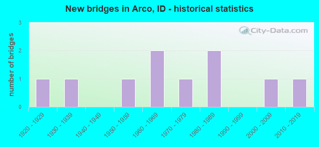
- New bridges - historical statistics
- 11920-1929
- 11930-1939
- 11950-1959
- 21960-1969
- 11970-1979
- 21980-1989
- 12000-2009
- 12010-2019


- Bridge Condition - Deck
- 20.0%Very good
- 60.0%Good
- 10.0%Satisfactory
- 10.0%Fair

- Bridge Condition - Superstructure
- 40.0%Very good
- 40.0%Good
- 10.0%Satisfactory
- 10.0%Fair

- Bridge Condition - Substructure
- 20.0%Very good
- 30.0%Good
- 40.0%Satisfactory
- 10.0%Fair

- Bridge Condition - Channel
- 44.4%Very good
- 55.6%Good
Find on map >> Show street view
Structure Number: 12915, Location: 18.7 NE. LOWMAN (Lat: 44.136111, Lng: -115.314167), Route carried "on" structure: State highway 21, Year Built: 1988, Status: Open, Structure Length: 5.18m (16.99ft), Average Daily Traffic: 700 (year 2019), Truck Traffic: 14%, Average Future Daily Traffic: 1,050 (year 2039), Design Load: HS 25 or greater, Features Intersected: CHAPMAN CREEK
Minimum Vertical Clearance: 30+ m (98+ ft), Kilometerpoint: 146.144, Lanes on structure: 2, Base Highway Network: Yes, Owner: State Highway Agency, Approaching Roadway Width: 8.5m (27.9ft), Skew: 6 degrees, Material/Design: Prestressed concrete, Design/Construction: Stringer/Multi-beam, Number Of Spans In Main Unit: 3, Length of Maximum Span: 16.8m (55.1ft), Curb-To-Curb Width: 9.4m (30.8ft), Out-to-Out Width: 10.3m (33.8ft)
Condition: Deck: Good, Superstructure: Very good, Substructure: Good, Channel: Very good, Operating Rating: 65.3 metric tons, Method Used To Determine Operating Rating: Load Factor (LF), Inventory Rating: 39.0 metric tons, Method Used To Determine Inventory Rating: Load Factor (LF), Structural Evaluation: Better than present minimum criteria, Deck Geometry: Equal to present minimum criteria, Waterway Adequacy: Equal to present desirable criteria, Approach Roadway Alignment: Equal to present desirable criteria, Designated Inspection Frequency: Every 48 months, Inspection Date: October 2020, Deck Structure Type: Concrete Cast-file-Place, Wearing Surface/Protective System: Wearing Surface: Epoxy Overlay, Deck Protection: Epoxy Coated Reinforcing
Find on map >> Show street view
Structure Number: 13195, Location: 1 W. ARCO (Lat: 43.615389, Lng: -113.310111), Route carried "on" structure: US 93, Year Built: 1958, Status: Open, Structure Length: 1.62m (5.31ft), Average Daily Traffic: 2,100 (year 2019), Truck Traffic: 16%, Average Future Daily Traffic: 3,150 (year 2039), Design Load: HS 20, Features Intersected: BIG LOST RIVER
Minimum Vertical Clearance: 30+ m (98+ ft), Kilometerpoint: 397.312, Lanes on structure: 2, Base Highway Network: Yes, Owner: State Highway Agency, Approaching Roadway Width: 10.4m (34.1ft), Material/Design: Concrete, Design/Construction: Tee Beam, Number Of Spans In Main Unit: 1, Length of Maximum Span: 15.5m (50.9ft), Curb-To-Curb Width: 10.4m (34.1ft), Out-to-Out Width: 11.1m (36.4ft)
Condition: Deck: Very good, Superstructure: Good, Substructure: Satisfactory, Channel: Good, Operating Rating: 47.2 metric tons, Method Used To Determine Operating Rating: Load Factor (LF), Inventory Rating: 28.1 metric tons, Method Used To Determine Inventory Rating: Load Factor (LF), Structural Evaluation: Equal to present minimum criteria, Deck Geometry: Somewhat better than minimum adequacy, Waterway Adequacy: Equal to present desirable criteria, Approach Roadway Alignment: Equal to present desirable criteria, Length Of Structure Improvement: 2.26m (7.41ft), Designated Inspection Frequency: Every 48 months, Inspection Date: July 2019, Bridge Improvement Cost: $488,000, Roadway Improvement Cost: $49,000, Total Project Cost: $732,000 ( Estimate for 2019), Deck Structure Type: Concrete Cast-file-Place, Wearing Surface/Protective System: Wearing Surface: Latex Concrete
Find on map >> Show street view
Structure Number: 1795, Location: 1.0 N. ARCO (Lat: 43.651611, Lng: -113.317167), Route carried "on" structure: US 93, Year Built: 1962, Status: Open, Structure Length: 0.79m (2.59ft), Average Daily Traffic: 2,000 (year 2019), Truck Traffic: 16%, Average Future Daily Traffic: 3,000 (year 2039), Design Load: HS 20, Features Intersected: ARCO CANAL
Minimum Vertical Clearance: 30+ m (98+ ft), Kilometerpoint: 135.104, Lanes on structure: 2, Base Highway Network: Yes (Inventory Route: US0, Subroute: 1), Owner: State Highway Agency, Approaching Roadway Width: 11.0m (36.1ft), Skew: 4 degrees, Material/Design: Concrete, Design/Construction: Frame, Number Of Spans In Main Unit: 1, Length of Maximum Span: 7.9m (25.9ft), Curb-To-Curb Width: 14.4m (47.2ft), Out-to-Out Width: 15.3m (50.2ft)
Condition: Deck: Good, Superstructure: Good, Substructure: Good, Channel: Good, Operating Rating: 35.4 metric tons, Method Used To Determine Operating Rating: Load Factor (LF), Inventory Rating: 20.9 metric tons, Method Used To Determine Inventory Rating: Load Factor (LF), Structural Evaluation: Somewhat better than minimum adequacy, Deck Geometry: Superior to present desirable criteria, Waterway Adequacy: Superior to present desirable criteria, Approach Roadway Alignment: Equal to present desirable criteria, Length Of Structure Improvement: 1.40m (4.59ft), Designated Inspection Frequency: Every 24 months, Inspection Date: October 2021, Bridge Improvement Cost: $334,000, Roadway Improvement Cost: $33,000, Total Project Cost: $501,000 ( Estimate for 2021), Deck Structure Type: Concrete Cast-file-Place, Wearing Surface/Protective System: Wearing Surface: Bituminous
Find on map >> Show street view
Structure Number: 17955, Location: 2.4 N. ARCO (Lat: 43.671361, Lng: -113.328694), Route carried "on" structure: US 93, Year Built: 1962, Status: Open, Structure Length: 0.98m (3.22ft), Average Daily Traffic: 2,000 (year 2019), Truck Traffic: 16%, Average Future Daily Traffic: 3,000 (year 2039), Design Load: HS 20, Features Intersected: SPRING CREEK
Minimum Vertical Clearance: 30+ m (98+ ft), Kilometerpoint: 137.491, Lanes on structure: 2, Base Highway Network: Yes (Inventory Route: US0, Subroute: 1), Owner: State Highway Agency, Approaching Roadway Width: 10.4m (34.1ft), Material/Design: Concrete, Design/Construction: Stringer/Multi-beam, Number Of Spans In Main Unit: 1, Length of Maximum Span: 9.4m (30.8ft), Curb-To-Curb Width: 10.5m (34.4ft), Out-to-Out Width: 11.0m (36.1ft)
Condition: Deck: Good, Superstructure: Good, Substructure: Good, Channel: Very good, Operating Rating: 67.1 metric tons, Method Used To Determine Operating Rating: Load Factor (LF), Inventory Rating: 39.9 metric tons, Method Used To Determine Inventory Rating: Load Factor (LF), Structural Evaluation: Better than present minimum criteria, Deck Geometry: Equal to present minimum criteria, Waterway Adequacy: Superior to present desirable criteria, Approach Roadway Alignment: Equal to present desirable criteria, Length Of Structure Improvement: 1.65m (5.41ft), Designated Inspection Frequency: Every 24 months, Inspection Date: October 2021, Bridge Improvement Cost: $392,000, Roadway Improvement Cost: $39,000, Total Project Cost: $588,000 ( Estimate for 2021), Deck Structure Type: Concrete Cast-file-Place, Wearing Surface/Protective System: Wearing Surface: Latex Concrete
Find on map >> Show street view
Structure Number: 3044, Location: IN COEUR D'ALENE;APPLEWAY (Lat: 47.701639, Lng: -116.814778), Route carried "on" structure: City street 7185, Year Built: 1971, Status: Open, Structure Length: 3.47m (11.38ft), Average Daily Traffic: 3,300 (year 2019), Truck Traffic: 4%, Average Future Daily Traffic: 4,950 (year 2039), Design Load: HS 20, Features Intersected: APPLEWAY PED OP
Minimum Vertical Clearance: 30+ m (98+ ft), Kilometerpoint: 0.151, Lanes on structure: 2, Owner: City or Municipal Highway Agency, Approaching Roadway Width: 15.2m (49.9ft), Skew: 1 degrees, Material/Design: Concrete, Design/Construction: Tee Beam, Number Of Spans In Main Unit: 3, Length of Maximum Span: 11.3m (37.1ft), Curb or Sidewalk Widths: Left: 1.2m (3.9ft), Right: 0.2m (0.7ft), Curb-To-Curb Width: 13.4m (44.0ft), Out-to-Out Width: 15.3m (50.2ft)
Condition: Deck: Satisfactory, Superstructure: Satisfactory, Substructure: Fair, Operating Rating: 64.4 metric tons, Method Used To Determine Operating Rating: Load Factor (LF), Inventory Rating: 39.0 metric tons, Method Used To Determine Inventory Rating: Load Factor (LF), Structural Evaluation: Somewhat better than minimum adequacy, Deck Geometry: Better than present minimum criteria, Approach Roadway Alignment: Equal to present desirable criteria, Designated Inspection Frequency: Every 24 months, Inspection Date: June 2021, Deck Structure Type: Concrete Cast-file-Place, Wearing Surface/Protective System: Wearing Surface: Monolithic Concrete
Find on map >> Show street view
Structure Number: 3144, Location: 3.5 S. 0.9 E. ARCO (Lat: 43.587889, Lng: -113.280333), Route carried "on" structure: County highway , Year Built: 1930, Year Reconstructed: 1987, Status: Posted for load, Structure Length: 1.19m (3.90ft), Average Daily Traffic: 30 (year 2019), Truck Traffic: 33%, Average Future Daily Traffic: 45 (year 2039), Design Load: HS 20, Features Intersected: BIG LOST RIVER, Facility Carried by Structure: 2150 N
Minimum Vertical Clearance: 30+ m (98+ ft), Kilometerpoint: 164.938, Lanes on structure: 2, Owner: County Highway Agency, Approaching Roadway Width: 6.1m (20.0ft), Material/Design: Prestressed concrete, Design/Construction: Tee Beam, Number Of Spans In Main Unit: 1, Length of Maximum Span: 11.6m (38.1ft), Curb or Sidewalk Widths: Left: 0.2m (0.7ft), Right: 0.2m (0.7ft), Curb-To-Curb Width: 6.9m (22.6ft), Out-to-Out Width: 7.3m (24.0ft)
Condition: Deck: Good, Superstructure: Good, Substructure: Satisfactory, Channel: Good, Operating Rating: 16.2 metric tons, Method Used To Determine Operating Rating: Allowable Stress (AS), Inventory Rating: 11.7 metric tons, Method Used To Determine Inventory Rating: Allowable Stress (AS), Structural Evaluation: Meets minimum limits, Deck Geometry: Somewhat better than minimum adequacy, Waterway Adequacy: Equal to present desirable criteria, Approach Roadway Alignment: Equal to present desirable criteria, Bridge Posting: Required (Relationship of Operating Rating to Maximum Legal Load: 10.0 - 19.9% below), Length Of Structure Improvement: 1.89m (6.20ft), Designated Inspection Frequency: Every 24 months, Inspection Date: July 2021, Bridge Improvement Cost: $286,000, Roadway Improvement Cost: $29,000, Total Project Cost: $430,000 ( Estimate for 2019), Deck Structure Type: Concrete Cast-file-Place, Wearing Surface/Protective System: Wearing Surface: Bituminous
Find on map >> Show street view
Structure Number: 3145, Location: 2.1 N. 2.2 W. ARCO (Lat: 43.667306, Lng: -113.342722), Route carried "on" structure: County highway , Year Built: 1987, Status: Open, Structure Length: 1.83m (6.00ft), Average Daily Traffic: 260 (year 2019), Truck Traffic: 8%, Average Future Daily Traffic: 390 (year 2039), Design Load: HS 20, Features Intersected: E.BRANCH BIG LOST RIVER, Facility Carried by Structure: 2700 N
Minimum Vertical Clearance: 30+ m (98+ ft), Kilometerpoint: 165.626, Lanes on structure: 2, Owner: County Highway Agency, Approaching Roadway Width: 7.9m (25.9ft), Material/Design: Prestressed concrete, Design/Construction: Stringer/Multi-beam, Number Of Spans In Main Unit: 1, Length of Maximum Span: 17.7m (58.1ft), Curb-To-Curb Width: 8.7m (28.5ft), Out-to-Out Width: 9.7m (31.8ft)
Condition: Deck: Good, Superstructure: Very good, Substructure: Satisfactory, Channel: Good, Operating Rating: 53.1 metric tons, Method Used To Determine Operating Rating: Allowable Stress (AS), Inventory Rating: 37.8 metric tons, Method Used To Determine Inventory Rating: Allowable Stress (AS), Structural Evaluation: Equal to present minimum criteria, Deck Geometry: Equal to present minimum criteria, Waterway Adequacy: Equal to present desirable criteria, Approach Roadway Alignment: Equal to present desirable criteria, Designated Inspection Frequency: Every 48 months, Inspection Date: July 2019, Deck Structure Type: Concrete Cast-file-Place, Wearing Surface/Protective System: Wearing Surface: Bituminous
Find on map >> Show street view
Structure Number: 31491, Location: 0.9 S. 0.7 W. ARCO (Lat: 43.623944, Lng: -113.311944), Route carried "on" structure: County highway , Year Built: 2012, Status: Open, Structure Length: 2.71m (8.89ft), Average Daily Traffic: 190 (year 2019), Truck Traffic: 16%, Average Future Daily Traffic: 285 (year 2039), Design Load: HL 93, Features Intersected: BIG LOST RIVER, Facility Carried by Structure: 2400 NORTH ROAD
Minimum Vertical Clearance: 30+ m (98+ ft), Kilometerpoint: 203.512, Lanes on structure: 2, Owner: County Highway Agency, Approaching Roadway Width: 8.5m (27.9ft), Material/Design: Prestressed concrete, Design/Construction: Box Beam or Girders - Multiple, Number Of Spans In Main Unit: 1, Length of Maximum Span: 25.9m (85.0ft), Curb-To-Curb Width: 10.2m (33.5ft), Out-to-Out Width: 11.0m (36.1ft)
Condition: Deck: Very good, Superstructure: Very good, Substructure: Very good, Channel: Very good, Operating Rating: 90.6 metric tons, Method Used To Determine Operating Rating: Load Factor (LF), Inventory Rating: 63.5 metric tons, Method Used To Determine Inventory Rating: Load Factor (LF), Structural Evaluation: Equal to present desirable criteria, Deck Geometry: Better than present minimum criteria, Waterway Adequacy: Superior to present desirable criteria, Approach Roadway Alignment: Equal to present desirable criteria, Designated Inspection Frequency: Every 48 months, Inspection Date: July 2018, Deck Structure Type: Concrete Cast-file-Place, Wearing Surface/Protective System: Wearing Surface: Monolithic Concrete, Deck Protection: Epoxy Coated Reinforcing
Find on map >> Show street view
Structure Number: 3151, Location: 1.5 N. 2.3 W. ARCO (Lat: 43.658667, Lng: -113.356194), Route carried "on" structure: County highway 6749, Year Built: 1926, Status: Open, Structure Length: 1.10m (3.61ft), Average Daily Traffic: 270 (year 2019), Truck Traffic: 19%, Average Future Daily Traffic: 405 (year 2039), Design Load: H 15, Features Intersected: BIG LOST RIVER
Minimum Vertical Clearance: 30+ m (98+ ft), Kilometerpoint: 166.380, Lanes on structure: 2, Owner: County Highway Agency, Approaching Roadway Width: 6.1m (20.0ft), Skew: 3 degrees, Material/Design: Concrete, Design/Construction: Tee Beam, Number Of Spans In Main Unit: 1, Length of Maximum Span: 10.7m (35.1ft), Curb-To-Curb Width: 7.0m (23.0ft), Out-to-Out Width: 7.9m (25.9ft)
Condition: Deck: Fair, Superstructure: Fair, Substructure: Satisfactory, Channel: Good, Operating Rating: 45.4 metric tons, Method Used To Determine Operating Rating: Load Factor (LF), Inventory Rating: 27.2 metric tons, Method Used To Determine Inventory Rating: Load Factor (LF), Structural Evaluation: Somewhat better than minimum adequacy, Deck Geometry: Meets minimum limits, Waterway Adequacy: Equal to present desirable criteria, Approach Roadway Alignment: Better than present minimum criteria, Length Of Structure Improvement: 1.83m (6.00ft), Designated Inspection Frequency: Every 24 months, Inspection Date: July 2021, Bridge Improvement Cost: $297,000, Roadway Improvement Cost: $30,000, Total Project Cost: $446,000 ( Estimate for 2015), Deck Structure Type: Concrete Cast-file-Place, Wearing Surface/Protective System: Wearing Surface: Bituminous
Find on map >> Show street view
Structure Number: 3342, Location: IN MERIDIAN (Lat: 43.599500, Lng: -116.369028), Route carried "on" structure: City street , Year Built: 2001, Status: Open, Structure Length: 1.04m (3.41ft), Average Daily Traffic: 1,000 (year 2019), Truck Traffic: 5%, Average Future Daily Traffic: 1,500 (year 2039), Design Load: HS 25 or greater, Features Intersected: FIVE MILE CREEK, Facility Carried by Structure: WOODBRIDGE RD
Minimum Vertical Clearance: 30+ m (98+ ft), Kilometerpoint: 16.552, Lanes on structure: 2, Owner: County Highway Agency, Approaching Roadway Width: 7.3m (24.0ft), Skew: 1 degrees, Material/Design: Prestressed concrete, Design/Construction: Box Beam or Girders - Multiple, Number Of Spans In Main Unit: 1, Length of Maximum Span: 10.1m (33.1ft), Curb or Sidewalk Widths: Left: 1.8m (5.9ft), Right: 1.8m (5.9ft), Curb-To-Curb Width: 7.4m (24.3ft), Out-to-Out Width: 11.0m (36.1ft)
Condition: Deck: Good, Superstructure: Very good, Substructure: Very good, Channel: Very good, Inventory Rating: 42.6 metric tons, Method Used To Determine Inventory Rating: Load Factor (LF), Structural Evaluation: Equal to present desirable criteria, Deck Geometry: Meets minimum limits, Waterway Adequacy: Superior to present desirable criteria, Approach Roadway Alignment: Better than present minimum criteria, Designated Inspection Frequency: Every 48 months, Inspection Date: March 2019, Deck Structure Type: Concrete Cast-file-Place, Wearing Surface/Protective System: Wearing Surface: Monolithic Concrete, Deck Protection: Epoxy Coated Reinforcing