Bridge Statistics for Argonne, Wisconsin (WI)
Condition, Traffic, Stress, Structural Evaluation, Project Costs
- National Bridge Inventory (NBI) Statistics
- 10Number of bridges
- 49ft / 14.6mTotal length
- $767,000Total costs
- 4,407Total average daily traffic
- 356Total average daily truck traffic
- 7,989Total future (year 2039) average daily traffic
- National Bridge Inventory (NBI) Registered Bridges for Argonne
- No street view available for this location
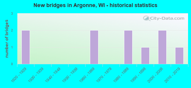
- New bridges - historical statistics
- 21920-1929
- 21960-1969
- 21980-1989
- 11990-1999
- 22000-2009
- 12010-2019

- Bridge Condition - Deck
- 37.5%Good
- 12.5%Satisfactory
- 25.0%Fair
- 25.0%Poor

- Bridge Condition - Superstructure
- 50.0%Good
- 37.5%Satisfactory
- 12.5%Fair

- Bridge Condition - Substructure
- 12.5%Very good
- 50.0%Good
- 12.5%Satisfactory
- 25.0%Poor

- Bridge Condition - Channel
- 10.0%Excellent
- 50.0%Very good
- 20.0%Good
- 10.0%Satisfactory
- 10.0%Fair

- Bridge Condition - Culverts
- 50.0%Good
- 50.0%Fair
Find on map >> Show street view
Structure Number: B210001, Location: 6.4M E JCT USH 45 TO N (Lat: 45.572183, Lng: -89.018406), Route carried "on" structure: US 8, Year Built: 1960, Year Reconstructed: 1982, Status: Open, Structure Length: 4.22m (13.85ft), Average Daily Traffic: 2,900 (year 2019), Truck Traffic: 9%, Average Future Daily Traffic: 6,280 (year 2040), Design Load: HS 20, Features Intersected: WOLF RIVER
Minimum Vertical Clearance: 30+ m (98+ ft), Kilometerpoint: 0.000, Lanes on structure: 2, Base Highway Network: Yes, Owner: State Highway Agency, Approaching Roadway Width: 12.2m (40.0ft), Material/Design: Steel continuous, Design/Construction: Stringer/Multi-beam, Number Of Spans In Main Unit: 3, Length of Maximum Span: 15.8m (51.8ft), Curb-To-Curb Width: 10.2m (33.5ft), Out-to-Out Width: 11.1m (36.4ft)
Condition: Deck: Fair, Superstructure: Satisfactory, Substructure: Satisfactory, Channel: Very good, Operating Rating: 50.6 metric tons, Method Used To Determine Operating Rating: Load Factor (LF), Inventory Rating: 29.2 metric tons, Method Used To Determine Inventory Rating: Load Factor (LF), Structural Evaluation: Equal to present minimum criteria, Deck Geometry: Meets minimum limits, Waterway Adequacy: Superior to present desirable criteria, Approach Roadway Alignment: Equal to present desirable criteria, Designated Inspection Frequency: Every 24 months, Inspection Date: May 2021, Deck Structure Type: Concrete Cast-file-Place, Wearing Surface/Protective System: Wearing Surface: Epoxy Overlay, Deck Protection: Epoxy Coated Reinforcing
Find on map >> Show street view
Structure Number: B210002, Location: 2.5M N JCT STH 32 TO N (Lat: 45.688647, Lng: -88.868317), Route carried "on" structure: State highway 55, Year Built: 1962, Year Reconstructed: 1982, Status: Open, Structure Length: 2.57m (8.43ft), Average Daily Traffic: 200 (year 2019), Truck Traffic: 8%, Average Future Daily Traffic: 300 (year 2040), Design Load: H 20, Features Intersected: N BR PESHTIGO RIVER
Minimum Vertical Clearance: 30+ m (98+ ft), Kilometerpoint: 0.000, Lanes on structure: 2, Owner: State Highway Agency, Approaching Roadway Width: 9.8m (32.2ft), Material/Design: Steel continuous, Design/Construction: Stringer/Multi-beam, Number Of Spans In Main Unit: 2, Length of Maximum Span: 12.2m (40.0ft), Curb-To-Curb Width: 9.9m (32.5ft), Out-to-Out Width: 10.5m (34.4ft)
Condition: Deck: Poor, Superstructure: Good, Substructure: Good, Channel: Good, Operating Rating: 52.3 metric tons, Method Used To Determine Operating Rating: Load Factor (LF), Inventory Rating: 30.8 metric tons, Method Used To Determine Inventory Rating: Load Factor (LF), Structural Evaluation: Better than present minimum criteria, Deck Geometry: Better than present minimum criteria, Waterway Adequacy: Equal to present desirable criteria, Approach Roadway Alignment: Equal to present desirable criteria, Length Of Structure Improvement: 3.02m (9.91ft), Designated Inspection Frequency: Every 24 months, Inspection Date: August 2021, Bridge Improvement Cost: $285,000, Roadway Improvement Cost: $28,000, Total Project Cost: $428,000 ( Estimate for 2021), Deck Structure Type: Concrete Cast-file-Place, Wearing Surface/Protective System: Wearing Surface: Monolithic Concrete, Deck Protection: Epoxy Coated Reinforcing
Find on map >> Show street view
Structure Number: B210009, Location: 1.7M N JCT CTH G (Lat: 45.672917, Lng: -88.818667), Route carried "on" structure: City street , Year Built: 1982, Status: Open, Structure Length: 0.92m (3.02ft), Average Daily Traffic: 60 (year 2019), Average Future Daily Traffic: 66 (year 2039), Design Load: H 15, Features Intersected: N BR PESHTIGO RIVER, Facility Carried by Structure: LRD DICK SAMZ RD
Minimum Vertical Clearance: 30+ m (98+ ft), Kilometerpoint: 0.000, Lanes on structure: 2, Owner: Town or Township Highway Agency, Approaching Roadway Width: 7.3m (24.0ft), Skew: 6 degrees, Material/Design: Steel, Design/Construction: Culvert, Number Of Spans In Main Unit: 4, Length of Maximum Span: 1.7m (5.6ft)
Condition: Channel: Very good, Culverts: Fair, Operating Rating: 53.9 metric tons, Method Used To Determine Operating Rating: Field evaluation and documented engineering judgment, Inventory Rating: 24.3 metric tons, Method Used To Determine Inventory Rating: Field evaluation and documented engineering judgment, Structural Evaluation: Somewhat better than minimum adequacy, Waterway Adequacy: Equal to present desirable criteria, Approach Roadway Alignment: Equal to present desirable criteria, Designated Inspection Frequency: Every 24 months, Inspection Date: August 2020, Deck Structure Type: Corrugated Steel, Wearing Surface/Protective System: Wearing Surface: Bituminous
Find on map >> Show street view
Structure Number: B210013, Location: 0.6M S JCT CTH G (Lat: 45.650278, Lng: -88.820500), Route carried "on" structure: City street , Year Built: 1989, Status: Open, Structure Length: 1.18m (3.87ft), Average Daily Traffic: 91 (year 2019), Average Future Daily Traffic: 100 (year 2039), Design Load: HS 20, Features Intersected: W BR PESHTIGO RIVER, Facility Carried by Structure: LRD WAGGONER RD
Minimum Vertical Clearance: 30+ m (98+ ft), Kilometerpoint: 0.000, Lanes on structure: 2, Owner: Town or Township Highway Agency, Approaching Roadway Width: 7.3m (24.0ft), Material/Design: Concrete, Design/Construction: Slab, Number Of Spans In Main Unit: 1, Length of Maximum Span: 11.8m (38.7ft), Curb-To-Curb Width: 7.3m (24.0ft), Out-to-Out Width: 7.9m (25.9ft)
Condition: Deck: Satisfactory, Superstructure: Satisfactory, Substructure: Good, Channel: Very good, Operating Rating: 76.7 metric tons, Method Used To Determine Operating Rating: Load Factor (LF), Inventory Rating: 45.4 metric tons, Method Used To Determine Inventory Rating: Load Factor (LF), Structural Evaluation: Equal to present minimum criteria, Deck Geometry: Equal to present minimum criteria, Waterway Adequacy: Equal to present desirable criteria, Approach Roadway Alignment: Equal to present desirable criteria, Designated Inspection Frequency: Every 24 months, Inspection Date: August 2020, Deck Structure Type: Concrete Cast-file-Place, Wearing Surface/Protective System: Wearing Surface: Monolithic Concrete, Deck Protection: Epoxy Coated Reinforcing
Find on map >> Show street view
Structure Number: B210017, Location: 11.0M N JCT STH 32 TO N (Lat: 45.791183, Lng: -88.820900), Route carried "on" structure: State highway 55, Year Built: 2001, Status: Open, Structure Length: 0.83m (2.72ft), Average Daily Traffic: 160 (year 2019), Truck Traffic: 14%, Average Future Daily Traffic: 140 (year 2040), Design Load: HS 20, Features Intersected: POPPLE RIVER
Minimum Vertical Clearance: 30+ m (98+ ft), Kilometerpoint: 0.000, Lanes on structure: 2, Owner: State Highway Agency, Approaching Roadway Width: 10.4m (34.1ft), Skew: 2 degrees, Material/Design: Concrete, Design/Construction: Slab, Number Of Spans In Main Unit: 1, Length of Maximum Span: 6.1m (20.0ft), Curb-To-Curb Width: 10.4m (34.1ft), Out-to-Out Width: 11.0m (36.1ft)
Condition: Deck: Good, Superstructure: Good, Substructure: Good, Channel: Very good, Operating Rating: 68.6 metric tons, Method Used To Determine Operating Rating: Load Factor (LF), Inventory Rating: 40.5 metric tons, Method Used To Determine Inventory Rating: Load Factor (LF), Structural Evaluation: Better than present minimum criteria, Deck Geometry: Better than present minimum criteria, Waterway Adequacy: Equal to present desirable criteria, Approach Roadway Alignment: Equal to present desirable criteria, Designated Inspection Frequency: Every 48 months, Inspection Date: August 2021, Deck Structure Type: Concrete Cast-file-Place, Wearing Surface/Protective System: Wearing Surface: Monolithic Concrete
Find on map >> Show street view
Structure Number: B210018, Location: 15.2M N JCT STH 32 TO N (Lat: 45.852611, Lng: -88.820050), Route carried "on" structure: State highway 55, Year Built: 2001, Status: Open, Structure Length: 0.81m (2.66ft), Average Daily Traffic: 160 (year 2019), Truck Traffic: 12%, Average Future Daily Traffic: 210 (year 2040), Design Load: HS 20, Features Intersected: JONES CREEK
Minimum Vertical Clearance: 30+ m (98+ ft), Kilometerpoint: 0.000, Lanes on structure: 2, Owner: State Highway Agency, Approaching Roadway Width: 10.4m (34.1ft), Material/Design: Concrete, Design/Construction: Slab, Number Of Spans In Main Unit: 1, Length of Maximum Span: 7.3m (24.0ft), Curb-To-Curb Width: 10.4m (34.1ft), Out-to-Out Width: 11.0m (36.1ft)
Condition: Deck: Good, Superstructure: Good, Substructure: Good, Channel: Very good, Operating Rating: 68.6 metric tons, Method Used To Determine Operating Rating: Load Factor (LF), Inventory Rating: 40.5 metric tons, Method Used To Determine Inventory Rating: Load Factor (LF), Structural Evaluation: Better than present minimum criteria, Deck Geometry: Better than present minimum criteria, Waterway Adequacy: Equal to present desirable criteria, Approach Roadway Alignment: Equal to present desirable criteria, Designated Inspection Frequency: Every 48 months, Inspection Date: August 2021, Deck Structure Type: Concrete Cast-file-Place, Wearing Surface/Protective System: Wearing Surface: Monolithic Concrete
Find on map >> Show street view
Structure Number: B21003, Location: 3.6M E JCT STH 32 (Lat: 45.655639, Lng: -88.810611), Route carried "on" structure: County highway , Year Built: 2019, Status: Open, Structure Length: 1.30m (4.27ft), Average Daily Traffic: 760 (year 2019), Truck Traffic: 5%, Average Future Daily Traffic: 810 (year 2039), Design Load: HL 93, Features Intersected: S BRANCH PESHTIGO RIVER, Facility Carried by Structure: CTH G
Minimum Vertical Clearance: 30+ m (98+ ft), Kilometerpoint: 0.000, Lanes on structure: 2, Owner: County Highway Agency, Approaching Roadway Width: 10.4m (34.1ft), Material/Design: Concrete, Design/Construction: Slab, Number Of Spans In Main Unit: 1, Length of Maximum Span: 12.2m (40.0ft), Curb-To-Curb Width: 9.1m (29.9ft), Out-to-Out Width: 9.9m (32.5ft)
Condition: Deck: Good, Superstructure: Good, Substructure: Very good, Channel: Excellent, Operating Rating: 48.6 metric tons, Method Used To Determine Operating Rating: Load and Resistance Factor Rating (LRFR) rating reported by rating factor(RF) method using HL-93 loadings, Inventory Rating: 37.3 metric tons, Method Used To Determine Inventory Rating: Load and Resistance Factor Rating (LRFR) rating reported by rating factor(RF) method using HL-93 loadings, Structural Evaluation: Better than present minimum criteria, Deck Geometry: Equal to present minimum criteria, Waterway Adequacy: Superior to present desirable criteria, Approach Roadway Alignment: Equal to present desirable criteria, Designated Inspection Frequency: Every 24 months, Inspection Date: August 2020, Deck Structure Type: Concrete Cast-file-Place, Wearing Surface/Protective System: Wearing Surface: Monolithic Concrete
Find on map >> Show street view
Structure Number: P210034, Location: 2.5M N JCT CTH G (Lat: 45.683361, Lng: -88.815889), Route carried "on" structure: City street , Year Built: 1921, Status: Open, Structure Length: 1.03m (3.38ft), Average Daily Traffic: 30 (year 2019), Average Future Daily Traffic: 33 (year 2040), Design Load: H 15, Features Intersected: N BR PESHTIGO RIVER, Facility Carried by Structure: LRD CARDINAL RD
Minimum Vertical Clearance: 30+ m (98+ ft), Kilometerpoint: 0.000, Lanes on structure: 2, Owner: Town or Township Highway Agency, Approaching Roadway Width: 4.3m (14.1ft), Material/Design: Concrete, Design/Construction: Stringer/Multi-beam, Number Of Spans In Main Unit: 1, Length of Maximum Span: 9.8m (32.2ft), Curb-To-Curb Width: 5.8m (19.0ft), Out-to-Out Width: 6.8m (22.3ft)
Condition: Deck: Fair, Superstructure: Satisfactory, Substructure: Poor, Channel: Satisfactory, Operating Rating: 49.0 metric tons, Method Used To Determine Operating Rating: Load Factor (LF), Inventory Rating: 19.4 metric tons, Method Used To Determine Inventory Rating: Load Factor (LF), Structural Evaluation: Meets minimum limits, Deck Geometry: Meets minimum limits, Waterway Adequacy: Equal to present desirable criteria, Approach Roadway Alignment: Equal to present desirable criteria, Length Of Structure Improvement: 1.46m (4.79ft), Designated Inspection Frequency: Every 12 months, Inspection Date: August 2021, Bridge Improvement Cost: $114,000, Roadway Improvement Cost: $11,000, Total Project Cost: $171,000 ( Estimate for 2021), Deck Structure Type: Concrete Cast-file-Place, Wearing Surface/Protective System: Wearing Surface: Monolithic Concrete
Find on map >> Show street view
Structure Number: P210035, Location: 3.2M N JCT CTH G (Lat: 45.692028, Lng: -88.816083), Route carried "on" structure: City street , Year Built: 1924, Status: Open, Structure Length: 1.01m (3.31ft), Average Daily Traffic: 26 (year 2019), Average Future Daily Traffic: 28 (year 2040), Design Load: H 15, Features Intersected: N BR PESHTIGO RIVER, Facility Carried by Structure: LRD CARDINAL RD
Minimum Vertical Clearance: 30+ m (98+ ft), Kilometerpoint: 0.000, Lanes on structure: 2, Owner: Town or Township Highway Agency, Approaching Roadway Width: 4.3m (14.1ft), Material/Design: Concrete, Design/Construction: Stringer/Multi-beam, Number Of Spans In Main Unit: 1, Length of Maximum Span: 9.6m (31.5ft), Curb-To-Curb Width: 5.8m (19.0ft), Out-to-Out Width: 6.8m (22.3ft)
Condition: Deck: Poor, Superstructure: Fair, Substructure: Poor, Channel: Fair, Operating Rating: 49.0 metric tons, Method Used To Determine Operating Rating: Load Factor (LF), Inventory Rating: 21.1 metric tons, Method Used To Determine Inventory Rating: Load Factor (LF), Structural Evaluation: Meets minimum limits, Deck Geometry: Meets minimum limits, Waterway Adequacy: Equal to present desirable criteria, Approach Roadway Alignment: Equal to present desirable criteria, Length Of Structure Improvement: 1.46m (4.79ft), Designated Inspection Frequency: Every 12 months, Underwater Inspection Frequency: Every 12 months, Inspection Date: August 2021, Underwater Inspection Date: September 2021, Bridge Improvement Cost: $112,000, Roadway Improvement Cost: $11,000, Total Project Cost: $168,000 ( Estimate for 2021), Deck Structure Type: Concrete Cast-file-Place, Wearing Surface/Protective System: Wearing Surface: Monolithic Concrete
Find on map >> Show street view
Structure Number: P210401, Location: 0.6M S CTH G (Lat: 45.649028, Lng: -88.856000), Route carried "on" structure: City street , Year Built: 1998, Status: Open, Structure Length: 0.76m (2.49ft), Average Daily Traffic: 20 (year 2019), Average Future Daily Traffic: 22 (year 2039), Design Load: HS 20, Features Intersected: W BR PESHTIGO RIVER, Facility Carried by Structure: LRD PESHTIGO RIVER
Minimum Vertical Clearance: 30+ m (98+ ft), Kilometerpoint: 0.000, Lanes on structure: 2, Owner: Town or Township Highway Agency, Approaching Roadway Width: 6.7m (22.0ft), Material/Design: Aluminum, Iron, Design/Construction: Culvert, Number Of Spans In Main Unit: 3, Length of Maximum Span: 2.0m (6.6ft)
Condition: Channel: Good, Culverts: Good, Operating Rating: 53.9 metric tons, Method Used To Determine Operating Rating: Field evaluation and documented engineering judgment, Inventory Rating: 32.4 metric tons, Method Used To Determine Inventory Rating: Field evaluation and documented engineering judgment, Structural Evaluation: Better than present minimum criteria, Waterway Adequacy: Equal to present desirable criteria, Approach Roadway Alignment: Equal to present desirable criteria, Designated Inspection Frequency: Every 48 months, Inspection Date: August 2020, Wearing Surface/Protective System: Wearing Surface: Bituminous