Bridge Statistics for Arkadelphia, Arkansas (AR)
Condition, Traffic, Stress, Structural Evaluation, Project Costs
- National Bridge Inventory (NBI) Statistics
- 40Number of bridges
- 463ft / 141mTotal length
- $8,258,000Total costs
- 343,868Total average daily traffic
- 54,745Total average daily truck traffic
- National Bridge Inventory (NBI) Registered Bridges for Arkadelphia
- No street view available for this location
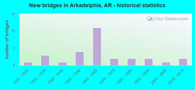
- New bridges - historical statistics
- 11920-1929
- 31930-1939
- 11940-1949
- 41950-1959
- 111960-1969
- 21970-1979
- 21980-1989
- 21990-1999
- 12000-2009
- 22010-2019
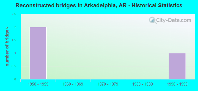
- Reconstructed bridges - Historical Statistics
- 21950-1959
- 01960-1969
- 01970-1979
- 01980-1989
- 11990-1999
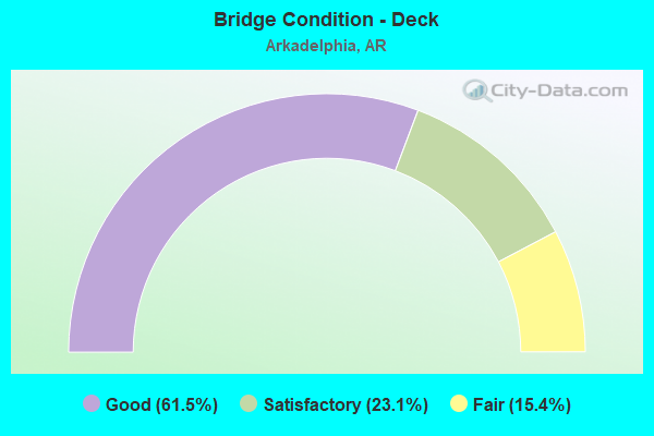
- Bridge Condition - Deck
- 61.5%Good
- 23.1%Satisfactory
- 15.4%Fair
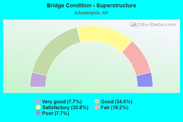
- Bridge Condition - Superstructure
- 7.7%Very good
- 34.6%Good
- 30.8%Satisfactory
- 19.2%Fair
- 7.7%Poor
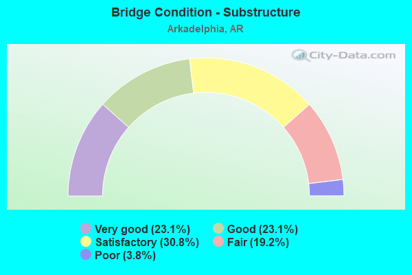
- Bridge Condition - Substructure
- 23.1%Very good
- 23.1%Good
- 30.8%Satisfactory
- 19.2%Fair
- 3.8%Poor
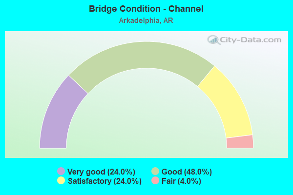
- Bridge Condition - Channel
- 24.0%Very good
- 48.0%Good
- 24.0%Satisfactory
- 4.0%Fair
Find on map >> Show street view
Structure Number: 899, Location: .4 MI S JCT SH 7 (Lat: 34.173969, Lng: -93.071478), Route carried "on" structure: US 67, Year Built: 1930, Year Reconstructed: 1957, Status: Open, Structure Length: 33.62m (110.30ft), Average Daily Traffic: 8,700 (year 2018), Truck Traffic: 1%, Average Future Daily Traffic: 9,412 (year 2028), Design Load: H 20, Features Intersected: CADDO RIVER
Minimum Vertical Clearance: 30+ m (98+ ft), Kilometerpoint: 6.017, Lanes on structure: 2, Base Highway Network: Yes, Owner: State Highway Agency, Approaching Roadway Width: 11.6m (38.1ft), Material/Design: Steel, Design/Construction: Stringer/Multi-beam, Number Of Spans In Main Unit: 2, Number Of Approach Spans: 30, Length of Maximum Span: 30.8m (101.0ft), Curb-To-Curb Width: 8.5m (27.9ft), Out-to-Out Width: 9.6m (31.5ft)
Condition: Deck: Fair, Superstructure: Fair, Substructure: Fair, Channel: Good, Operating Rating: 51.7 metric tons, Method Used To Determine Operating Rating: Load Factor (LF), Inventory Rating: 31.8 metric tons, Method Used To Determine Inventory Rating: Load Factor (LF), Structural Evaluation: Somewhat better than minimum adequacy, Deck Geometry: Meets minimum limits, Waterway Adequacy: Equal to present desirable criteria, Approach Roadway Alignment: Equal to present minimum criteria, Length Of Structure Improvement: 34.78m (114.11ft), Designated Inspection Frequency: Every 24 months, Critical Feature Inspection Frequency: Every 24 months, Inspection Date: August 2020, Roadway Improvement Cost: $265,000, Total Project Cost: $4,010,000, Deck Structure Type: Concrete Cast-file-Place, Wearing Surface/Protective System: Wearing Surface: Monolithic Concrete
Find on map >> Show street view
Structure Number: 911, Location: .76 MI N OF SH 51 (Lat: 34.133431, Lng: -93.057719), Route carried "on" structure: US 67, Year Built: 1929, Year Reconstructed: 1957, Status: Open, Structure Length: 2.13m (6.99ft), Average Daily Traffic: 9,500 (year 2018), Truck Traffic: 4%, Average Future Daily Traffic: 11,800 (year 2038), Design Load: H 20, Features Intersected: MILL CREEK
Minimum Vertical Clearance: 30+ m (98+ ft), Kilometerpoint: 1.223, Lanes on structure: 2, Base Highway Network: Yes, Owner: State Highway Agency, Approaching Roadway Width: 12.2m (40.0ft), Skew: 2 degrees, Material/Design: Concrete, Design/Construction: Tee Beam, Number Of Spans In Main Unit: 2, Length of Maximum Span: 10.7m (35.1ft), Curb-To-Curb Width: 12.2m (40.0ft), Out-to-Out Width: 12.8m (42.0ft)
Condition: Deck: Good, Superstructure: Good, Substructure: Satisfactory, Channel: Satisfactory, Operating Rating: 39.9 metric tons, Method Used To Determine Operating Rating: Load Factor (LF), Inventory Rating: 23.6 metric tons, Method Used To Determine Inventory Rating: Load Factor (LF), Structural Evaluation: Somewhat better than minimum adequacy, Deck Geometry: Somewhat better than minimum adequacy, Waterway Adequacy: Equal to present minimum criteria, Approach Roadway Alignment: Better than present minimum criteria, Designated Inspection Frequency: Every 24 months, Critical Feature Inspection Frequency: Every 24 months, Inspection Date: December 2021, Deck Structure Type: Concrete Cast-file-Place, Wearing Surface/Protective System: Wearing Surface: Bituminous
Find on map >> Show street view
Structure Number: 1616, Location: JCT WALNUT ST (Lat: 34.113128, Lng: -93.056219), Route carried "on" structure: US 67, Year Built: 1931, Status: Open, Structure Length: 1.80m (5.91ft), Average Daily Traffic: 3,400 (year 2018), Truck Traffic: 1%, Average Future Daily Traffic: 4,223 (year 2028), Design Load: H 15, Features Intersected: MADDOX CREEK
Minimum Vertical Clearance: 30+ m (98+ ft), Kilometerpoint: 23.878, Lanes on structure: 2, Owner: State Highway Agency, Approaching Roadway Width: 12.2m (40.0ft), Skew: 4 degrees, Material/Design: Steel, Design/Construction: Stringer/Multi-beam, Number Of Spans In Main Unit: 3, Length of Maximum Span: 5.8m (19.0ft), Curb-To-Curb Width: 8.9m (29.2ft), Out-to-Out Width: 9.2m (30.2ft)
Condition: Deck: Good, Superstructure: Fair, Substructure: Satisfactory, Channel: Satisfactory, Operating Rating: 32.7 metric tons, Method Used To Determine Operating Rating: Load Factor (LF), Inventory Rating: 19.1 metric tons, Method Used To Determine Inventory Rating: Load Factor (LF), Structural Evaluation: Somewhat better than minimum adequacy, Deck Geometry: Meets minimum limits, Waterway Adequacy: Equal to present minimum criteria, Approach Roadway Alignment: Equal to present minimum criteria, Designated Inspection Frequency: Every 24 months, Critical Feature Inspection Frequency: Every 24 months, Inspection Date: November 2019, Deck Structure Type: Concrete Cast-file-Place, Wearing Surface/Protective System: Wearing Surface: Bituminous
Find on map >> Show street view
Structure Number: 3004, Location: 1.64 MI W JCT SH 51 (Lat: 34.124569, Lng: -93.123350), Route carried "on" structure: State highway 8, Year Built: 1955, Status: Open, Structure Length: 1.71m (5.61ft), Average Daily Traffic: 1,820 (year 2018), Truck Traffic: 7%, Average Future Daily Traffic: 2,500 (year 2032), Design Load: H 15, Features Intersected: LITTLE DECEIPER CREEK, Facility Carried by Structure: Clark S-5 LM 24.05
Minimum Vertical Clearance: 30+ m (98+ ft), Kilometerpoint: 38.705, Lanes on structure: 2, Base Highway Network: Yes, Owner: State Highway Agency, Approaching Roadway Width: 7.9m (25.9ft), Skew: 3 degrees, Material/Design: Concrete, Design/Construction: Slab, Number Of Spans In Main Unit: 2, Length of Maximum Span: 8.5m (27.9ft), Curb-To-Curb Width: 7.3m (24.0ft), Out-to-Out Width: 8.1m (26.6ft)
Condition: Deck: Satisfactory, Superstructure: Satisfactory, Substructure: Satisfactory, Channel: Good, Operating Rating: 38.1 metric tons, Method Used To Determine Operating Rating: Load Factor (LF), Inventory Rating: 22.7 metric tons, Method Used To Determine Inventory Rating: Load Factor (LF), Structural Evaluation: Equal to present minimum criteria, Deck Geometry: Meets minimum limits, Waterway Adequacy: Equal to present minimum criteria, Approach Roadway Alignment: Equal to present minimum criteria, Designated Inspection Frequency: Every 24 months, Critical Feature Inspection Frequency: Every 24 months, Inspection Date: October 2021, Deck Structure Type: Concrete Cast-file-Place, Wearing Surface/Protective System: Wearing Surface: Bituminous
Find on map >> Show street view
Structure Number: 3023, Location: 2.58 MI E US 67 (Lat: 36.402650, Lng: -90.543019), Route carried "on" structure: US 62, Year Built: 1956, Status: Open, Structure Length: 21.92m (71.92ft), Average Daily Traffic: 4,200 (year 2018), Truck Traffic: 1%, Average Future Daily Traffic: 4,824 (year 2028), Design Load: H 20, Features Intersected: BLACK RIVER
Minimum Vertical Clearance: 30+ m (98+ ft), Kilometerpoint: 4.152, Lanes on structure: 2, Base Highway Network: Yes, Owner: State Highway Agency, Approaching Roadway Width: 11.6m (38.1ft), Material/Design: Steel, Design/Construction: Stringer/Multi-beam, Number Of Spans In Main Unit: 3, Number Of Approach Spans: 8, Length of Maximum Span: 36.6m (120.1ft), Curb or Sidewalk Widths: Left: 0.5m (1.6ft), Right: 0.5m (1.6ft), Curb-To-Curb Width: 7.9m (25.9ft), Out-to-Out Width: 9.6m (31.5ft)
Condition: Deck: Fair, Superstructure: Poor, Substructure: Fair, Channel: Good, Operating Rating: 48.1 metric tons, Method Used To Determine Operating Rating: Load Factor (LF), Inventory Rating: 29.0 metric tons, Method Used To Determine Inventory Rating: Load Factor (LF), Structural Evaluation: Meets minimum limits, Deck Geometry: High priority of corrective action, Waterway Adequacy: Superior to present desirable criteria, Approach Roadway Alignment: Better than present minimum criteria, Length Of Structure Improvement: 23.16m (75.98ft), Designated Inspection Frequency: Every 24 months, Critical Feature Inspection Frequency: Every 24 months, Inspection Date: October 2021, Roadway Improvement Cost: $400,000, Total Project Cost: $2,948,000, Deck Structure Type: Concrete Cast-file-Place, Wearing Surface/Protective System: Wearing Surface: Monolithic Concrete
Find on map >> Show street view
Structure Number: 369, Location: JCT I-30 & CO.RD. 73 (Lat: 34.092650, Lng: -93.108511), Route carried "on" structure: County highway 73, Year Built: 1965, Status: Open, Structure Length: 7.59m (24.90ft), Average Daily Traffic: 418 (year 1987), Truck Traffic: 1%, Average Future Daily Traffic: 111 (year 2007), Design Load: H 15, Features Intersected: I-30 SEC 14 LOG 70.77
Minimum Vertical Clearance: 30+ m (98+ ft), Kilometerpoint: 2.895, Lanes on structure: 2, Lanes under structure: 4, Owner: State Highway Agency, Approaching Roadway Width: 8.5m (27.9ft), Material/Design: Steel, Design/Construction: Stringer/Multi-beam, Number Of Spans In Main Unit: 4, Length of Maximum Span: 23.2m (76.1ft), Curb-To-Curb Width: 7.3m (24.0ft), Out-to-Out Width: 8.6m (28.2ft)
Condition: Deck: Satisfactory, Superstructure: Good, Substructure: Satisfactory, Operating Rating: 44.5 metric tons, Method Used To Determine Operating Rating: Load Factor (LF), Inventory Rating: 27.2 metric tons, Method Used To Determine Inventory Rating: Load Factor (LF), Structural Evaluation: Equal to present minimum criteria, Deck Geometry: Meets minimum limits, Underclear: Meets minimum limits, Approach Roadway Alignment: Equal to present desirable criteria, Designated Inspection Frequency: Every 24 months, Critical Feature Inspection Frequency: Every 24 months, Inspection Date: April 2020, Deck Structure Type: Concrete Cast-file-Place, Wearing Surface/Protective System: Wearing Surface: Monolithic Concrete
Find on map >> Show street view
Structure Number: 3693, Location: JCT I-30 & CO.RD. 32 (Lat: 34.142711, Lng: -93.080819), Route carried "on" structure: County highway 32, Year Built: 1965, Status: Open, Structure Length: 7.32m (24.02ft), Average Daily Traffic: 3,800 (year 1987), Truck Traffic: 1%, Average Future Daily Traffic: 672 (year 2007), Design Load: H 15, Features Intersected: I 30 S-14 LM 74.59
Minimum Vertical Clearance: 30+ m (98+ ft), Kilometerpoint: 1.865, Lanes on structure: 2, Lanes under structure: 4, Owner: State Highway Agency, Approaching Roadway Width: 8.5m (27.9ft), Material/Design: Steel, Design/Construction: Stringer/Multi-beam, Number Of Spans In Main Unit: 4, Length of Maximum Span: 20.4m (66.9ft), Curb-To-Curb Width: 7.3m (24.0ft), Out-to-Out Width: 8.7m (28.5ft)
Condition: Deck: Fair, Superstructure: Satisfactory, Substructure: Fair, Operating Rating: 36.3 metric tons, Method Used To Determine Operating Rating: Load Factor (LF), Inventory Rating: 21.8 metric tons, Method Used To Determine Inventory Rating: Load Factor (LF), Structural Evaluation: Somewhat better than minimum adequacy, Deck Geometry: High priority of replacement, Underclear: Meets minimum limits, Approach Roadway Alignment: Better than present minimum criteria, Designated Inspection Frequency: Every 24 months, Critical Feature Inspection Frequency: Every 24 months, Inspection Date: March 2020, Deck Structure Type: Concrete Cast-file-Place, Wearing Surface/Protective System: Wearing Surface: Monolithic Concrete
Find on map >> Show street view
Structure Number: 3705, Location: JCT I-30 & CO.RD.30 (Lat: 34.171861, Lng: -93.075278), Route carried "on" structure: County highway 30, Year Built: 1965, Status: Open, Structure Length: 7.59m (24.90ft), Average Daily Traffic: 46 (year 1987), Truck Traffic: 1%, Average Future Daily Traffic: 474 (year 2007), Design Load: H 15, Features Intersected: I 30-SEC 14 LOG 76.64
Minimum Vertical Clearance: 30+ m (98+ ft), Kilometerpoint: 9.767, Lanes on structure: 2, Lanes under structure: 4, Owner: State Highway Agency, Approaching Roadway Width: 8.5m (27.9ft), Skew: 2 degrees, Material/Design: Steel, Design/Construction: Stringer/Multi-beam, Number Of Spans In Main Unit: 4, Length of Maximum Span: 22.9m (75.1ft), Curb-To-Curb Width: 7.3m (24.0ft), Out-to-Out Width: 8.6m (28.2ft)
Condition: Deck: Fair, Superstructure: Satisfactory, Substructure: Very good, Operating Rating: 45.4 metric tons, Method Used To Determine Operating Rating: Load Factor (LF), Inventory Rating: 27.2 metric tons, Method Used To Determine Inventory Rating: Load Factor (LF), Structural Evaluation: Equal to present minimum criteria, Deck Geometry: Equal to present minimum criteria, Underclear: Meets minimum limits, Approach Roadway Alignment: Equal to present desirable criteria, Designated Inspection Frequency: Every 24 months, Critical Feature Inspection Frequency: Every 24 months, Inspection Date: April 2020, Deck Structure Type: Concrete Cast-file-Place, Wearing Surface/Protective System: Wearing Surface: Monolithic Concrete
Find on map >> Show street view
Structure Number: 6082, Location: 2.5 MI S JCT SH 8 (Lat: 34.097589, Lng: -93.133258), Route carried "on" structure: State highway 51, Year Built: 1987, Status: Open, Structure Length: 3.26m (10.70ft), Average Daily Traffic: 1,887 (year 2018), Truck Traffic: 5%, Average Future Daily Traffic: 2,600 (year 2033), Design Load: HS 20, Features Intersected: BIG DECEIPHER
Minimum Vertical Clearance: 30+ m (98+ ft), Kilometerpoint: 43.314, Lanes on structure: 2, Base Highway Network: Yes, Owner: State Highway Agency, Approaching Roadway Width: 12.2m (40.0ft), Skew: 3 degrees, Material/Design: Steel, Design/Construction: Stringer/Multi-beam, Number Of Spans In Main Unit: 3, Length of Maximum Span: 10.7m (35.1ft), Curb-To-Curb Width: 12.2m (40.0ft), Out-to-Out Width: 13.1m (43.0ft)
Condition: Deck: Good, Superstructure: Very good, Substructure: Good, Channel: Very good, Operating Rating: 54.4 metric tons, Method Used To Determine Operating Rating: Load Factor (LF), Inventory Rating: 32.7 metric tons, Method Used To Determine Inventory Rating: Load Factor (LF), Structural Evaluation: Better than present minimum criteria, Deck Geometry: Better than present minimum criteria, Waterway Adequacy: Better than present minimum criteria, Approach Roadway Alignment: Equal to present desirable criteria, Designated Inspection Frequency: Every 24 months, Critical Feature Inspection Frequency: Every 24 months, Inspection Date: March 2020, Deck Structure Type: Concrete Cast-file-Place, Wearing Surface/Protective System: Wearing Surface: Monolithic Concrete
Find on map >> Show street view
Structure Number: 6083, Location: 2.4 MI SW SH 8 (Lat: 34.105619, Lng: -93.109578), Route carried "on" structure: State highway 51, Year Built: 1987, Status: Open, Structure Length: 3.26m (10.70ft), Average Daily Traffic: 3,100 (year 2018), Truck Traffic: 5%, Average Future Daily Traffic: 2,600 (year 2033), Design Load: HS 20, Features Intersected: LITTLE DECEIPHER
Minimum Vertical Clearance: 30+ m (98+ ft), Kilometerpoint: 45.728, Lanes on structure: 2, Base Highway Network: Yes, Owner: State Highway Agency, Approaching Roadway Width: 12.2m (40.0ft), Skew: 3 degrees, Material/Design: Steel, Design/Construction: Stringer/Multi-beam, Number Of Spans In Main Unit: 3, Length of Maximum Span: 10.7m (35.1ft), Curb-To-Curb Width: 12.2m (40.0ft), Out-to-Out Width: 13.1m (43.0ft)
Condition: Deck: Good, Superstructure: Good, Substructure: Good, Channel: Very good, Operating Rating: 54.4 metric tons, Method Used To Determine Operating Rating: Load Factor (LF), Inventory Rating: 32.7 metric tons, Method Used To Determine Inventory Rating: Load Factor (LF), Structural Evaluation: Better than present minimum criteria, Deck Geometry: Equal to present minimum criteria, Waterway Adequacy: Equal to present desirable criteria, Approach Roadway Alignment: Equal to present desirable criteria, Designated Inspection Frequency: Every 24 months, Critical Feature Inspection Frequency: Every 24 months, Inspection Date: March 2020, Deck Structure Type: Concrete Cast-file-Place, Wearing Surface/Protective System: Wearing Surface: Monolithic Concrete
Find on map >> Show street view
Structure Number: 6165, Location: 0.2 MI NW JCT SH 7 (Lat: 34.117089, Lng: -93.031119), Route carried "on" structure: State highway 51, Year Built: 1993, Status: Open, Structure Length: 9.60m (31.50ft), Average Daily Traffic: 3,000 (year 2018), Truck Traffic: 1%, Average Future Daily Traffic: 3,499 (year 2028), Design Load: HS 20, Features Intersected: SALINE BAYOU
Minimum Vertical Clearance: 30+ m (98+ ft), Kilometerpoint: 2.253, Lanes on structure: 2, Base Highway Network: Yes, Owner: State Highway Agency, Approaching Roadway Width: 13.7m (44.9ft), Material/Design: Concrete, Design/Construction: Tee Beam, Number Of Spans In Main Unit: 9, Length of Maximum Span: 10.7m (35.1ft), Curb-To-Curb Width: 12.2m (40.0ft), Out-to-Out Width: 13.0m (42.7ft)
Condition: Deck: Good, Superstructure: Good, Substructure: Very good, Channel: Good, Operating Rating: 54.4 metric tons, Method Used To Determine Operating Rating: Load Factor (LF), Inventory Rating: 32.7 metric tons, Method Used To Determine Inventory Rating: Load Factor (LF), Structural Evaluation: Better than present minimum criteria, Deck Geometry: Equal to present minimum criteria, Waterway Adequacy: Equal to present desirable criteria, Approach Roadway Alignment: Superior to present desirable criteria, Designated Inspection Frequency: Every 24 months, Critical Feature Inspection Frequency: Every 24 months, Inspection Date: March 2021, Deck Structure Type: Concrete Cast-file-Place, Wearing Surface/Protective System: Wearing Surface: Monolithic Concrete
Find on map >> Show street view
Structure Number: 6962, Location: 2.25 Mi. W Jct US 67 (Lat: 34.118219, Lng: -93.093561), Route carried "on" structure: State highway 51, Year Built: 2004, Status: Open, Structure Length: 9.42m (30.91ft), Average Daily Traffic: 10,264 (year 2018), Truck Traffic: 3%, Average Future Daily Traffic: 19,669 (year 2027), Design Load: HS 20, Features Intersected: I 30 Sec. 14 log 72.86
Minimum Vertical Clearance: 5.04m (16.54ft), Kilometerpoint: 47.894, Lanes on structure: 5, Lanes under structure: 4, Base Highway Network: Yes, Owner: State Highway Agency, Approaching Roadway Width: 22.3m (73.2ft), Skew: 3 degrees, Material/Design: Steel continuous, Design/Construction: Stringer/Multi-beam, Number Of Spans In Main Unit: 4, Length of Maximum Span: 31.7m (104.0ft), Curb or Sidewalk Widths: Left: 1.8m (5.9ft), Right: 1.8m (5.9ft), Curb-To-Curb Width: 17.7m (58.1ft), Out-to-Out Width: 22.4m (73.5ft)
Condition: Deck: Good, Superstructure: Very good, Substructure: Very good, Operating Rating: 54.4 metric tons, Method Used To Determine Operating Rating: Load Factor (LF), Inventory Rating: 32.7 metric tons, Method Used To Determine Inventory Rating: Load Factor (LF), Structural Evaluation: Equal to present desirable criteria, Deck Geometry: High priority of replacement, Underclear: Equal to present minimum criteria, Approach Roadway Alignment: Equal to present desirable criteria, Designated Inspection Frequency: Every 24 months, Critical Feature Inspection Frequency: Every 24 months, Inspection Date: June 2020, Deck Structure Type: Concrete Cast-file-Place, Wearing Surface/Protective System: Wearing Surface: Monolithic Concrete
Find on map >> Show street view
Structure Number: 19035, Location: .1 MI W JCT US 67 (Lat: 34.113581, Lng: -93.056250), Route carried "on" structure: City street 60540, Year Built: 1948, Status: Posted for load, Structure Length: 0.94m (3.08ft), Average Daily Traffic: 42 (year 2018), Truck Traffic: 1%, Average Future Daily Traffic: 3,303 (year 2007), Design Load: H 15, Features Intersected: CREEK, Facility Carried by Structure: Arkadelphia Walnut
Minimum Vertical Clearance: 30+ m (98+ ft), Kilometerpoint: 1.094, Lanes on structure: 2, Owner: City or Municipal Highway Agency, Approaching Roadway Width: 7.0m (23.0ft), Material/Design: Concrete, Design/Construction: Tee Beam, Number Of Spans In Main Unit: 2, Length of Maximum Span: 4.6m (15.1ft), Curb-To-Curb Width: 7.1m (23.3ft), Out-to-Out Width: 7.7m (25.3ft)
Condition: Deck: Good, Superstructure: Poor, Substructure: Fair, Channel: Satisfactory, Operating Rating: 5.4 metric tons, Method Used To Determine Operating Rating: Load Factor (LF), Inventory Rating: 3.6 metric tons, Method Used To Determine Inventory Rating: Load Factor (LF), Structural Evaluation: High priority of replacement, Deck Geometry: Somewhat better than minimum adequacy, Waterway Adequacy: Better than present minimum criteria, Approach Roadway Alignment: Better than present minimum criteria, Bridge Posting: Required (Relationship of Operating Rating to Maximum Legal Load: > 39.9% below), Length Of Structure Improvement: 1.65m (5.41ft), Designated Inspection Frequency: Every 12 months, Critical Feature Inspection Frequency: Every 24 months, Inspection Date: April 2021, Roadway Improvement Cost: $187,000, Total Project Cost: $323,000, Deck Structure Type: Concrete Cast-file-Place, Wearing Surface/Protective System: Wearing Surface: Bituminous
Find on map >> Show street view
Structure Number: 19036, Location: 0.78 M N JCT CADDO ST. (Lat: 34.132300, Lng: -93.060931), Route carried "on" structure: City street 64640, Year Built: 1971, Status: Open, Structure Length: 2.10m (6.89ft), Average Daily Traffic: 2,200 (year 2018), Truck Traffic: 1%, Average Future Daily Traffic: 1,575 (year 2007), Design Load: H 15, Features Intersected: MILL CREEK, Facility Carried by Structure: N 12 STREET
Minimum Vertical Clearance: 30+ m (98+ ft), Kilometerpoint: 1.255, Lanes on structure: 2, Owner: City or Municipal Highway Agency, Approaching Roadway Width: 7.9m (25.9ft), Material/Design: Prestressed concrete, Design/Construction: Channel Beam, Number Of Spans In Main Unit: 3, Length of Maximum Span: 9.4m (30.8ft), Curb or Sidewalk Widths: Left: 1.1m (3.6ft), Right: 1.1m (3.6ft), Curb-To-Curb Width: 8.0m (26.2ft), Out-to-Out Width: 10.8m (35.4ft)
Condition: Deck: Satisfactory, Superstructure: Satisfactory, Substructure: Satisfactory, Channel: Good, Operating Rating: 40.8 metric tons, Method Used To Determine Operating Rating: Load Factor (LF), Inventory Rating: 24.5 metric tons, Method Used To Determine Inventory Rating: Load Factor (LF), Structural Evaluation: Equal to present minimum criteria, Deck Geometry: High priority of corrective action, Waterway Adequacy: Better than present minimum criteria, Approach Roadway Alignment: Equal to present desirable criteria, Designated Inspection Frequency: Every 24 months, Critical Feature Inspection Frequency: Every 24 months, Inspection Date: May 2021, Deck Structure Type: Concrete Precast Panels, Wearing Surface/Protective System: Wearing Surface: Monolithic Concrete
Find on map >> Show street view
Structure Number: 19037, Location: .01 MI N JCT WELCH ST. (Lat: 34.130669, Lng: -93.065450), Route carried "on" structure: City street 64670, Year Built: 1962, Status: Open, Structure Length: 1.25m (4.10ft), Average Daily Traffic: 2,100 (year 2018), Truck Traffic: 1%, Average Future Daily Traffic: 726 (year 2007), Design Load: H 15, Features Intersected: MILL CREEK, Facility Carried by Structure: N. 15TH ST.
Minimum Vertical Clearance: 30+ m (98+ ft), Kilometerpoint: 1.143, Lanes on structure: 2, Owner: City or Municipal Highway Agency, Approaching Roadway Width: 7.6m (24.9ft), Material/Design: Steel, Design/Construction: Stringer/Multi-beam, Number Of Spans In Main Unit: 1, Length of Maximum Span: 11.9m (39.0ft), Curb-To-Curb Width: 7.4m (24.3ft), Out-to-Out Width: 8.0m (26.2ft)
Condition: Deck: Good, Superstructure: Good, Substructure: Good, Channel: Good, Operating Rating: 43.5 metric tons, Method Used To Determine Operating Rating: Load Factor (LF), Inventory Rating: 26.3 metric tons, Method Used To Determine Inventory Rating: Load Factor (LF), Structural Evaluation: Equal to present minimum criteria, Deck Geometry: High priority of replacement, Waterway Adequacy: Better than present minimum criteria, Approach Roadway Alignment: Better than present minimum criteria, Designated Inspection Frequency: Every 24 months, Critical Feature Inspection Frequency: Every 24 months, Inspection Date: May 2021, Deck Structure Type: Concrete Cast-file-Place, Wearing Surface/Protective System: Wearing Surface: Bituminous
Find on map >> Show street view
Structure Number: 19038, Location: 0.25 MI S JCT CARTER RD (Lat: 34.134400, Lng: -93.054986), Route carried "on" structure: City street 64570, Year Built: 1964, Status: Open, Structure Length: 0.73m (2.40ft), Average Daily Traffic: 1,800 (year 2018), Truck Traffic: 1%, Average Future Daily Traffic: 2,000 (year 2038), Design Load: H 15, Features Intersected: MILL CREEK, Facility Carried by Structure: N. 8TH ST.
Minimum Vertical Clearance: 30+ m (98+ ft), Kilometerpoint: 1.175, Lanes on structure: 2, Owner: City or Municipal Highway Agency, Approaching Roadway Width: 6.7m (22.0ft), Material/Design: Concrete, Design/Construction: Channel Beam, Number Of Spans In Main Unit: 2, Length of Maximum Span: 3.7m (12.1ft), Curb-To-Curb Width: 7.0m (23.0ft), Out-to-Out Width: 7.4m (24.3ft)
Condition: Deck: Good, Superstructure: Fair, Substructure: Satisfactory, Channel: Satisfactory, Operating Rating: 54.4 metric tons, Method Used To Determine Operating Rating: Load Factor (LF), Inventory Rating: 32.7 metric tons, Method Used To Determine Inventory Rating: Load Factor (LF), Structural Evaluation: Somewhat better than minimum adequacy, Deck Geometry: High priority of corrective action, Waterway Adequacy: Somewhat better than minimum adequacy, Approach Roadway Alignment: Better than present minimum criteria, Length Of Structure Improvement: 1.43m (4.69ft), Designated Inspection Frequency: Every 24 months, Critical Feature Inspection Frequency: Every 24 months, Inspection Date: May 2021, Roadway Improvement Cost: $117,000, Total Project Cost: $220,000, Deck Structure Type: Concrete Precast Panels, Wearing Surface/Protective System: Wearing Surface: Bituminous
Find on map >> Show street view
Structure Number: 19039, Location: 0.4 MI OF JCT MAIN ST. (Lat: 34.115619, Lng: -93.058578), Route carried "on" structure: City street 64610, Year Built: 1968, Status: Open, Structure Length: 0.73m (2.40ft), Average Daily Traffic: 60 (year 2018), Truck Traffic: 1%, Average Future Daily Traffic: 1,462 (year 2007), Design Load: H 15, Features Intersected: CREEK, Facility Carried by Structure: S. 10TH ST.
Minimum Vertical Clearance: 30+ m (98+ ft), Kilometerpoint: 0.644, Lanes on structure: 2, Owner: City or Municipal Highway Agency, Approaching Roadway Width: 7.3m (24.0ft), Material/Design: Concrete, Design/Construction: Channel Beam, Number Of Spans In Main Unit: 2, Length of Maximum Span: 3.7m (12.1ft), Curb-To-Curb Width: 7.0m (23.0ft), Out-to-Out Width: 7.7m (25.3ft)
Condition: Deck: Good, Superstructure: Fair, Substructure: Fair, Channel: Very good, Operating Rating: 32.7 metric tons, Method Used To Determine Operating Rating: Load Factor (LF), Inventory Rating: 19.1 metric tons, Method Used To Determine Inventory Rating: Load Factor (LF), Structural Evaluation: Somewhat better than minimum adequacy, Deck Geometry: Somewhat better than minimum adequacy, Waterway Adequacy: Better than present minimum criteria, Approach Roadway Alignment: Better than present minimum criteria, Length Of Structure Improvement: 1.43m (4.69ft), Designated Inspection Frequency: Every 24 months, Critical Feature Inspection Frequency: Every 24 months, Inspection Date: March 2021, Roadway Improvement Cost: $187,000, Total Project Cost: $312,000, Deck Structure Type: Concrete Precast Panels, Wearing Surface/Protective System: Wearing Surface: Bituminous
Find on map >> Show street view
Structure Number: 1904, Location: 0.3 MI S JCT MAIN ST. (Lat: 34.116858, Lng: -93.060956), Route carried "on" structure: City street 64640, Year Built: 1962, Status: Posted for load, Structure Length: 0.79m (2.59ft), Average Daily Traffic: 48 (year 2018), Truck Traffic: 1%, Average Future Daily Traffic: 1,418 (year 2007), Design Load: H 15, Features Intersected: CREEK, Facility Carried by Structure: S. 12TH ST.
Minimum Vertical Clearance: 30+ m (98+ ft), Kilometerpoint: 0.483, Lanes on structure: 2, Owner: City or Municipal Highway Agency, Approaching Roadway Width: 6.7m (22.0ft), Material/Design: Steel, Design/Construction: Stringer/Multi-beam, Number Of Spans In Main Unit: 1, Length of Maximum Span: 7.6m (24.9ft), Curb or Sidewalk Widths: Left: 0.9m (3.0ft), Right: 0.0m, Curb-To-Curb Width: 7.3m (24.0ft), Out-to-Out Width: 8.4m (27.6ft)
Condition: Deck: Satisfactory, Superstructure: Fair, Substructure: Good, Channel: Good, Operating Rating: 38.1 metric tons, Method Used To Determine Operating Rating: Load Factor (LF), Inventory Rating: 22.7 metric tons, Method Used To Determine Inventory Rating: Load Factor (LF), Structural Evaluation: Somewhat better than minimum adequacy, Deck Geometry: Equal to present minimum criteria, Waterway Adequacy: Better than present minimum criteria, Approach Roadway Alignment: Better than present minimum criteria, Designated Inspection Frequency: Every 24 months, Critical Feature Inspection Frequency: Every 24 months, Inspection Date: May 2021, Deck Structure Type: Concrete Cast-file-Place, Wearing Surface/Protective System: Wearing Surface: Bituminous
Find on map >> Show street view
Structure Number: 19631, Location: .06MI S JCT M H RUSSELL D (Lat: 34.132989, Lng: -93.059525), Route carried "on" structure: City street 8690, Year Built: 1972, Status: Posted for load, Structure Length: 2.10m (6.89ft), Average Daily Traffic: 44 (year 1987), Truck Traffic: 10%, Average Future Daily Traffic: 53 (year 2007), Design Load: H 15, Features Intersected: MILL CREEK, Facility Carried by Structure: CAMPUS STREET
Minimum Vertical Clearance: 30+ m (98+ ft), Kilometerpoint: 0.097, Lanes on structure: 2, Owner: City or Municipal Highway Agency, Approaching Roadway Width: 7.9m (25.9ft), Material/Design: Prestressed concrete, Design/Construction: Channel Beam, Number Of Spans In Main Unit: 3, Length of Maximum Span: 9.4m (30.8ft), Curb or Sidewalk Widths: Left: 1.1m (3.6ft), Right: 1.1m (3.6ft), Curb-To-Curb Width: 8.0m (26.2ft), Out-to-Out Width: 10.8m (35.4ft)
Condition: Deck: Good, Superstructure: Good, Substructure: Poor, Channel: Good, Operating Rating: 29.9 metric tons, Method Used To Determine Operating Rating: Load Factor (LF), Inventory Rating: 18.1 metric tons, Method Used To Determine Inventory Rating: Load Factor (LF), Structural Evaluation: Meets minimum limits, Deck Geometry: Equal to present minimum criteria, Waterway Adequacy: Better than present minimum criteria, Approach Roadway Alignment: Equal to present desirable criteria, Bridge Posting: Required (Relationship of Operating Rating to Maximum Legal Load: > 39.9% below), Designated Inspection Frequency: Every 24 months, Critical Feature Inspection Frequency: Every 24 months, Inspection Date: May 2021, Deck Structure Type: Concrete Precast Panels, Wearing Surface/Protective System: Wearing Surface: Monolithic Concrete
Find on map >> Show street view
Structure Number: 21287, Location: 1.1 MI SE JCT CO RD 17 (Lat: 34.070250, Lng: -93.041336), Route carried "on" structure: County highway 19, Year Built: 1993, Status: Open, Structure Length: 2.83m (9.28ft), Average Daily Traffic: 560 (year 2018), Truck Traffic: 1%, Average Future Daily Traffic: 112 (year 2007), Design Load: H 15, Features Intersected: REYNOLDS DRAINAGE DITCH
Minimum Vertical Clearance: 30+ m (98+ ft), Kilometerpoint: 4.764, Lanes on structure: 2, Owner: County Highway Agency, Approaching Roadway Width: 9.1m (29.9ft), Material/Design: Prestressed concrete, Design/Construction: Channel Beam, Number Of Spans In Main Unit: 3, Length of Maximum Span: 9.4m (30.8ft), Curb-To-Curb Width: 8.5m (27.9ft), Out-to-Out Width: 9.0m (29.5ft)
Condition: Deck: Good, Superstructure: Good, Substructure: Very good, Channel: Very good, Operating Rating: 49.0 metric tons, Method Used To Determine Operating Rating: Load Factor (LF), Inventory Rating: 29.9 metric tons, Method Used To Determine Inventory Rating: Load Factor (LF), Structural Evaluation: Better than present minimum criteria, Deck Geometry: Somewhat better than minimum adequacy, Waterway Adequacy: Equal to present desirable criteria, Approach Roadway Alignment: Equal to present desirable criteria, Designated Inspection Frequency: Every 24 months, Critical Feature Inspection Frequency: Every 24 months, Inspection Date: April 2021, Deck Structure Type: Concrete Precast Panels, Wearing Surface/Protective System: Wearing Surface: Monolithic Concrete
Find on map >> Show street view
Structure Number: 23501, Location: .2 Mi. N. Jct CR 473 (Lat: 34.088958, Lng: -93.125108), Route carried "on" structure: County highway 76, Year Built: 2011, Status: Posted for load, Structure Length: 1.71m (5.61ft), Average Daily Traffic: 310 (year 2018), Truck Traffic: 1%, Average Future Daily Traffic: 60 (year 2007), Features Intersected: Deceiper Creek
Minimum Vertical Clearance: 30+ m (98+ ft), Kilometerpoint: 15.466, Lanes on structure: 2, Owner: County Highway Agency, Approaching Roadway Width: 7.0m (23.0ft), Material/Design: Steel, Design/Construction: Stringer/Multi-beam, Number Of Spans In Main Unit: 1, Length of Maximum Span: 16.6m (54.5ft), Curb-To-Curb Width: 6.9m (22.6ft), Out-to-Out Width: 7.3m (24.0ft)
Condition: Deck: Good, Superstructure: Satisfactory, Substructure: Good, Channel: Good, Operating Rating: 31.8 metric tons, Method Used To Determine Operating Rating: Load Factor (LF), Inventory Rating: 19.1 metric tons, Method Used To Determine Inventory Rating: Load Factor (LF), Structural Evaluation: Somewhat better than minimum adequacy, Deck Geometry: Meets minimum limits, Waterway Adequacy: Better than present minimum criteria, Approach Roadway Alignment: Better than present minimum criteria, Bridge Posting: Required (Relationship of Operating Rating to Maximum Legal Load: 10.0 - 19.9% below), Designated Inspection Frequency: Every 24 months, Critical Feature Inspection Frequency: Every 24 months, Inspection Date: July 2021, Deck Structure Type: Concrete Cast-file-Place
Find on map >> Show street view
Structure Number: 23893, Location: .62 MI SW JCT CR 19 (Lat: 34.074831, Lng: -93.059639), Route carried "on" structure: County highway 17, Year Built: 2017, Status: Open, Structure Length: 1.92m (6.30ft), Average Daily Traffic: 168 (year 2018), Truck Traffic: 1%, Average Future Daily Traffic: 125 (year 2037), Features Intersected: Deceiper Cr
Minimum Vertical Clearance: 30+ m (98+ ft), Kilometerpoint: 0.998, Lanes on structure: 2, Owner: County Highway Agency, Approaching Roadway Width: 6.1m (20.0ft), Material/Design: Steel, Design/Construction: Stringer/Multi-beam, Number Of Spans In Main Unit: 1, Length of Maximum Span: 18.1m (59.4ft), Curb-To-Curb Width: 5.8m (19.0ft), Out-to-Out Width: 5.9m (19.4ft)
Condition: Deck: Good, Superstructure: Good, Substructure: Good, Channel: Satisfactory, Operating Rating: 41.7 metric tons, Method Used To Determine Operating Rating: Load Factor (LF), Inventory Rating: 25.4 metric tons, Method Used To Determine Inventory Rating: Load Factor (LF), Structural Evaluation: Equal to present minimum criteria, Deck Geometry: High priority of corrective action, Waterway Adequacy: Equal to present minimum criteria, Approach Roadway Alignment: Equal to present minimum criteria, Designated Inspection Frequency: Every 24 months, Critical Feature Inspection Frequency: Every 24 months, Inspection Date: August 2021, Deck Structure Type: Concrete Cast-file-Place
Find on map >> Show street view
Structure Number: A3691, Location: 1.25 MI W JCT SH 51 & 8 (Lat: 34.098239, Lng: -93.104819), Route carried "on" structure: Interstate 30, Year Built: 1965, Status: Open, Structure Length: 3.41m (11.19ft), Average Daily Traffic: 14,500 (year 2018), Truck Traffic: 50%, Average Future Daily Traffic: 18,704 (year 2028), Design Load: HS 20+Mod, Features Intersected: LITTLE DECIPER
Minimum Vertical Clearance: 30+ m (98+ ft), Kilometerpoint: 114.618, Lanes on structure: 2, Base Highway Network: Yes, Owner: State Highway Agency, Approaching Roadway Width: 11.6m (38.1ft), Material/Design: Concrete, Design/Construction: Slab, Number Of Spans In Main Unit: 4, Length of Maximum Span: 8.5m (27.9ft), Curb-To-Curb Width: 12.2m (40.0ft), Out-to-Out Width: 13.6m (44.6ft)
Condition: Deck: Good, Superstructure: Good, Substructure: Very good, Channel: Very good, Operating Rating: 54.4 metric tons, Method Used To Determine Operating Rating: Load Factor (LF), Inventory Rating: 32.7 metric tons, Method Used To Determine Inventory Rating: Load Factor (LF), Structural Evaluation: Better than present minimum criteria, Deck Geometry: Better than present minimum criteria, Waterway Adequacy: Equal to present desirable criteria, Approach Roadway Alignment: Equal to present desirable criteria, Designated Inspection Frequency: Every 24 months, Critical Feature Inspection Frequency: Every 24 months, Inspection Date: December 2021, Deck Structure Type: Concrete Cast-file-Place, Wearing Surface/Protective System: Wearing Surface: Monolithic Concrete
Find on map >> Show street view
Structure Number: B3691, Location: 1.25 MI W JCT SH 51 & 8 (Lat: 34.097989, Lng: -93.104178), Route carried "on" structure: Interstate 30, Year Built: 1962, Year Reconstructed: 1999, Status: Open, Structure Length: 2.74m (8.99ft), Average Daily Traffic: 14,500 (year 2018), Truck Traffic: 54%, Average Future Daily Traffic: 18,704 (year 2028), Design Load: HS 20+Mod, Features Intersected: LITTLE DECIPER
Minimum Vertical Clearance: 30+ m (98+ ft), Kilometerpoint: 114.618, Lanes on structure: 2, Base Highway Network: Yes, Owner: State Highway Agency, Approaching Roadway Width: 11.6m (38.1ft), Material/Design: Concrete, Design/Construction: Slab, Number Of Spans In Main Unit: 3, Length of Maximum Span: 9.1m (29.9ft), Curb-To-Curb Width: 12.2m (40.0ft), Out-to-Out Width: 13.1m (43.0ft)
Condition: Deck: Satisfactory, Superstructure: Satisfactory, Substructure: Very good, Channel: Very good, Operating Rating: 54.4 metric tons, Method Used To Determine Operating Rating: Load Factor (LF), Inventory Rating: 32.7 metric tons, Method Used To Determine Inventory Rating: Load Factor (LF), Structural Evaluation: Equal to present minimum criteria, Deck Geometry: Better than present minimum criteria, Waterway Adequacy: Equal to present desirable criteria, Approach Roadway Alignment: Equal to present desirable criteria, Designated Inspection Frequency: Every 24 months, Critical Feature Inspection Frequency: Every 24 months, Inspection Date: October 2019, Deck Structure Type: Concrete Cast-file-Place
Find on map >> Show street view
Structure Number: M018, Location: 2.5 MI SE JCT SH 51 (Lat: 34.085600, Lng: -93.003219), Route carried "on" structure: State highway 7, Year Built: 1956, Status: Open, Structure Length: 2.90m (9.51ft), Average Daily Traffic: 1,700 (year 2018), Truck Traffic: 1%, Average Future Daily Traffic: 1,810 (year 2028), Design Load: H 15, Features Intersected: TUPELO CR.
Minimum Vertical Clearance: 30+ m (98+ ft), Kilometerpoint: 13.937, Lanes on structure: 2, Base Highway Network: Yes, Owner: State Highway Agency, Approaching Roadway Width: 9.4m (30.8ft), Material/Design: Concrete, Design/Construction: Channel Beam, Number Of Spans In Main Unit: 5, Length of Maximum Span: 5.8m (19.0ft), Curb-To-Curb Width: 7.3m (24.0ft), Out-to-Out Width: 7.7m (25.3ft)
Condition: Deck: Satisfactory, Superstructure: Satisfactory, Substructure: Satisfactory, Channel: Good, Operating Rating: 49.0 metric tons, Method Used To Determine Operating Rating: Load Factor (LF), Inventory Rating: 29.0 metric tons, Method Used To Determine Inventory Rating: Load Factor (LF), Structural Evaluation: Equal to present minimum criteria, Deck Geometry: Meets minimum limits, Waterway Adequacy: Better than present minimum criteria, Approach Roadway Alignment: Equal to present minimum criteria, Length Of Structure Improvement: 3.72m (12.20ft), Designated Inspection Frequency: Every 24 months, Critical Feature Inspection Frequency: Every 24 months, Inspection Date: January 2022, Roadway Improvement Cost: $156,000, Total Project Cost: $445,000, Deck Structure Type: Concrete Cast-file-Place, Wearing Surface/Protective System: Wearing Surface: Bituminous
Find on map >> Show street view
Structure Number: M0946, Location: 1.3 MI E JCT SH 7 (Lat: 34.117181, Lng: -93.006031), Route carried "on" structure: State highway 51, Year Built: 1957, Status: Open, Structure Length: 4.63m (15.19ft), Average Daily Traffic: 1,001 (year 2018), Truck Traffic: 1%, Average Future Daily Traffic: 1,014 (year 2028), Design Load: H 15, Features Intersected: TUPELO CREEK
Minimum Vertical Clearance: 30+ m (98+ ft), Kilometerpoint: 4.682, Lanes on structure: 2, Owner: State Highway Agency, Approaching Roadway Width: 8.5m (27.9ft), Material/Design: Concrete, Design/Construction: Channel Beam, Number Of Spans In Main Unit: 8, Length of Maximum Span: 5.8m (19.0ft), Curb-To-Curb Width: 7.2m (23.6ft), Out-to-Out Width: 7.7m (25.3ft)
Condition: Deck: Good, Superstructure: Satisfactory, Substructure: Satisfactory, Channel: Fair, Operating Rating: 54.4 metric tons, Method Used To Determine Operating Rating: Load Factor (LF), Inventory Rating: 32.7 metric tons, Method Used To Determine Inventory Rating: Load Factor (LF), Structural Evaluation: Equal to present minimum criteria, Deck Geometry: High priority of corrective action, Waterway Adequacy: Better than present minimum criteria, Approach Roadway Alignment: Equal to present minimum criteria, Designated Inspection Frequency: Every 24 months, Critical Feature Inspection Frequency: Every 24 months, Inspection Date: May 2021, Deck Structure Type: Concrete Precast Panels, Wearing Surface/Protective System: Wearing Surface: Bituminous
Find on map >> Show street view
Structure Number: M1223, Location: 1.0 MI S ARKADELPHIA (Lat: 34.094278, Lng: -93.075247), Route carried "on" structure: US 67, Year Built: 1931, Status: Open, Structure Length: 1.01m (3.31ft), Average Daily Traffic: 3,400 (year 2018), Truck Traffic: 1%, Average Future Daily Traffic: 4,223 (year 2028), Design Load: H 15, Features Intersected: DITCH
Minimum Vertical Clearance: 30+ m (98+ ft), Kilometerpoint: 21.142, Lanes on structure: 2, Owner: State Highway Agency, Approaching Roadway Width: 13.4m (44.0ft), Material/Design: Concrete, Design/Construction: Culvert, Number Of Spans In Main Unit: 3, Length of Maximum Span: 3.0m (9.8ft), Out-to-Out Width: 20.7m (67.9ft)
Condition: Channel: Good, Culverts: Good, Operating Rating: 41.7 metric tons, Method Used To Determine Operating Rating: Load Factor (LF), Inventory Rating: 25.4 metric tons, Method Used To Determine Inventory Rating: Load Factor (LF), Structural Evaluation: Equal to present minimum criteria, Waterway Adequacy: Equal to present minimum criteria, Approach Roadway Alignment: Better than present minimum criteria, Designated Inspection Frequency: Every 24 months, Critical Feature Inspection Frequency: Every 24 months, Inspection Date: December 2019
Find on map >> Show street view
Structure Number: M3021, Location: 0.25 M I E JCT SH 51 (Lat: 34.125008, Lng: -93.089308), Route carried "on" structure: Interstate 30, Year Built: 1965, Status: Open, Structure Length: 0.67m (2.20ft), Average Daily Traffic: 32,000 (year 2018), Truck Traffic: 52%, Average Future Daily Traffic: 33,787 (year 2028), Features Intersected: MILL CREEK
Minimum Vertical Clearance: 30+ m (98+ ft), Kilometerpoint: 117.933, Lanes on structure: 4, Base Highway Network: Yes, Owner: State Highway Agency, Approaching Roadway Width: 25.6m (84.0ft), Material/Design: Concrete, Design/Construction: Culvert, Number Of Spans In Main Unit: 2, Length of Maximum Span: 3.4m (11.2ft)
Condition: Channel: Satisfactory, Culverts: Good, Operating Rating: 39.0 metric tons, Method Used To Determine Operating Rating: Load Factor (LF), Inventory Rating: 23.6 metric tons, Method Used To Determine Inventory Rating: Load Factor (LF), Structural Evaluation: Somewhat better than minimum adequacy, Waterway Adequacy: Equal to present minimum criteria, Approach Roadway Alignment: Equal to present desirable criteria, Designated Inspection Frequency: Every 24 months, Critical Feature Inspection Frequency: Every 24 months, Inspection Date: March 2020
Find on map >> Show street view
Structure Number: M3022, Location: 2.0 MI SW JCT SH 7 (Lat: 34.156869, Lng: -93.077419), Route carried "on" structure: Interstate 30, Year Built: 1965, Status: Open, Structure Length: 1.01m (3.31ft), Average Daily Traffic: 32,000 (year 2018), Truck Traffic: 52%, Average Future Daily Traffic: 33,787 (year 2028), Features Intersected: CANEY CREEK
Minimum Vertical Clearance: 30+ m (98+ ft), Kilometerpoint: 121.650, Lanes on structure: 4, Base Highway Network: Yes, Owner: State Highway Agency, Approaching Roadway Width: 25.6m (84.0ft), Skew: 1 degrees, Material/Design: Concrete, Design/Construction: Culvert, Number Of Spans In Main Unit: 3, Length of Maximum Span: 3.0m (9.8ft)
Condition: Channel: Good, Culverts: Good, Operating Rating: 39.9 metric tons, Method Used To Determine Operating Rating: Load Factor (LF), Inventory Rating: 23.6 metric tons, Method Used To Determine Inventory Rating: Load Factor (LF), Structural Evaluation: Somewhat better than minimum adequacy, Waterway Adequacy: Better than present minimum criteria, Approach Roadway Alignment: Equal to present desirable criteria, Designated Inspection Frequency: Every 24 months, Critical Feature Inspection Frequency: Every 24 months, Inspection Date: March 2020
Find on map >> Show street view
Structure Number: 369, Location: JCT I-30 & CO.RD. 73 (Lat: 34.092650, Lng: -93.108511), Route carried "under" structure: Interstate 30, Structure Length: 0. m, Average Daily Traffic: 14,000 (year 2014), Truck Traffic: 1%, Features Intersected: I-30 SEC 14 LOG 70.77, Facility Carried by Structure: CR 73/N. Gum Sprgs
Minimum Vertical Clearance: 5.16m (16.93ft), Kilometerpoint: 113.893, Length of Maximum Span: 0.0m
Find on map >> Show street view
Structure Number: 369, Location: JCT I-30 & CO.RD. 73 (Lat: 34.092650, Lng: -93.108511), Route carried "under" structure: Interstate 30, Structure Length: 0. m, Average Daily Traffic: 14,000 (year 2014), Truck Traffic: 1%, Features Intersected: I-30 SEC 14 LOG 70.77, Facility Carried by Structure: CR 73/N. Gum Sprgs
Minimum Vertical Clearance: 5.09m (16.70ft), Kilometerpoint: 113.893, Length of Maximum Span: 0.0m
Find on map >> Show street view
Structure Number: 3693, Location: JCT I-30 & CO.RD. 32 (Lat: 34.142711, Lng: -93.080819), Route carried "under" structure: Interstate 30, Structure Length: 0. m, Average Daily Traffic: 29,000 (year 2013), Truck Traffic: 1%, Features Intersected: I 30 SEC 14 LOG 74.59, Facility Carried by Structure: CR 32 Z-D LM 1.15
Minimum Vertical Clearance: 6.58m (21.59ft), Kilometerpoint: 120.041, Length of Maximum Span: 0.0m
Find on map >> Show street view
Structure Number: 3693, Location: JCT I-30 & CO.RD. 32 (Lat: 34.142711, Lng: -93.080819), Route carried "under" structure: Interstate 30, Structure Length: 0. m, Average Daily Traffic: 29,000 (year 2013), Truck Traffic: 1%, Features Intersected: I 30 SEC 14 LOG 74.59, Facility Carried by Structure: CR 32 Z-D LM 1.15
Minimum Vertical Clearance: 6.91m (22.67ft), Kilometerpoint: 120.041, Length of Maximum Span: 0.0m
Find on map >> Show street view
Structure Number: 3705, Location: JCT I-30 & CO.RD.30 (Lat: 34.171861, Lng: -93.075278), Route carried "under" structure: Interstate 30, Structure Length: 0. m, Average Daily Traffic: 29,000 (year 2013), Truck Traffic: 1%, Features Intersected: I 30-SEC 14 LOG 76.64
Minimum Vertical Clearance: 4.93m (16.17ft), Kilometerpoint: 123.340, Length of Maximum Span: 0.0m
Find on map >> Show street view
Structure Number: 3705, Location: JCT I-30 & CO.RD.30 (Lat: 34.171861, Lng: -93.075278), Route carried "under" structure: Interstate 30, Structure Length: 0. m, Average Daily Traffic: 29,000 (year 2013), Truck Traffic: 1%, Features Intersected: I 30-SEC 14 LOG 76.64
Minimum Vertical Clearance: 5.15m (16.90ft), Kilometerpoint: 123.340, Length of Maximum Span: 0.0m
Find on map >> Show street view
Structure Number: 6678, Location: .29 MI N OF SH 51 (Lat: 34.126789, Lng: -93.057019), Route carried "under" structure: US 67, Structure Length: 0. m, Average Daily Traffic: 9,100 (year 2014), Truck Traffic: 1%, Features Intersected: U S 67 SEC 6, Facility Carried by Structure: PEDESTRIAN OVERPAS
Minimum Vertical Clearance: 5.21m (17.09ft), Kilometerpoint: 0.467, Length of Maximum Span: 0.0m
Find on map >> Show street view
Structure Number: 6962, Location: 2.25 Mi. W Jct US 67 (Lat: 34.118219, Lng: -93.093561), Route carried "under" structure: Interstate 30, Structure Length: 0. m, Average Daily Traffic: 14,000 (year 2014), Truck Traffic: 11%, Features Intersected: I 30 Sec. 14 log 72.86, Facility Carried by Structure: SH51Sec1KingOP
Minimum Vertical Clearance: 5.02m (16.47ft), Kilometerpoint: 117.257, Length of Maximum Span: 0.0m
Find on map >> Show street view
Structure Number: 6962, Location: 2.25 Mi. W Jct US 67 (Lat: 34.118219, Lng: -93.093561), Route carried "under" structure: Interstate 30, Structure Length: 0. m, Average Daily Traffic: 14,000 (year 2014), Truck Traffic: 11%, Features Intersected: I 30 Sec. 14 log 72.86, Facility Carried by Structure: SH51Sec1KingOP
Minimum Vertical Clearance: 5.14m (16.86ft), Kilometerpoint: 117.257, Length of Maximum Span: 0.0m
Find on map >> Show street view
Structure Number: 7316, Location: 0.36 MI E JCT US 67 (Lat: 34.120781, Lng: -93.046969), Route carried "under" structure: County highway 51, Structure Length: 0. m, Average Daily Traffic: 3,100 (year 2014), Truck Traffic: 10%, Features Intersected: SH 51, UPRR
Minimum Vertical Clearance: 7.55m (24.77ft), Kilometerpoint: 0.579, Length of Maximum Span: 0.0m
Find on map >> Show street view
Structure Number: M0945, Location: 0.65 IM JCT US 67 (Lat: 34.121439, Lng: -93.042600), Route carried "under" structure: State highway 51, Structure Length: 0. m, Average Daily Traffic: 3,100 (year 2014), Truck Traffic: 1%, Features Intersected: SH 51-SEC 2, Facility Carried by Structure: UPRR
Minimum Vertical Clearance: 5.27m (17.29ft), Kilometerpoint: 1.046, Length of Maximum Span: 0.0m