Bridge Statistics for Arlington Heights, Illinois (IL)
Condition, Traffic, Stress, Structural Evaluation, Project Costs
- National Bridge Inventory (NBI) Statistics
- 19Number of bridges
- 167ft / 50.7mTotal length
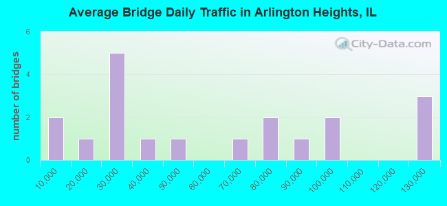
- 1,092,700Total average daily traffic
- 75,138Total average daily truck traffic
- National Bridge Inventory (NBI) Registered Bridges for Arlington Heights
- No street view available for this location
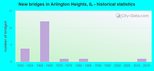
- New bridges - historical statistics
- 41950-1959
- 121960-1969
- 11970-1979
- 11980-1989
- 12010-2019
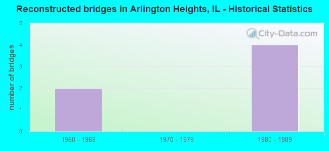
- Reconstructed bridges - Historical Statistics
- 21960-1969
- 01970-1979
- 41980-1989
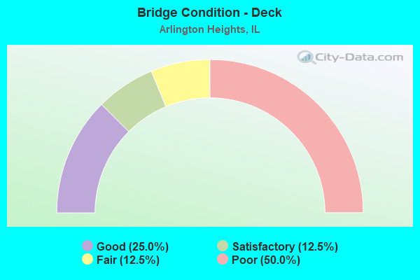
- Bridge Condition - Deck
- 25.0%Good
- 12.5%Satisfactory
- 12.5%Fair
- 50.0%Poor
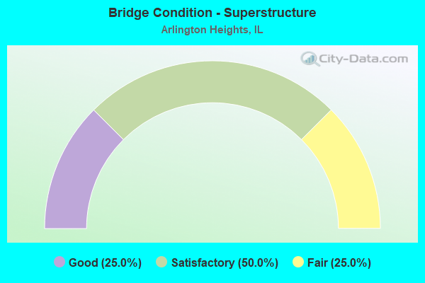
- Bridge Condition - Superstructure
- 25.0%Good
- 50.0%Satisfactory
- 25.0%Fair
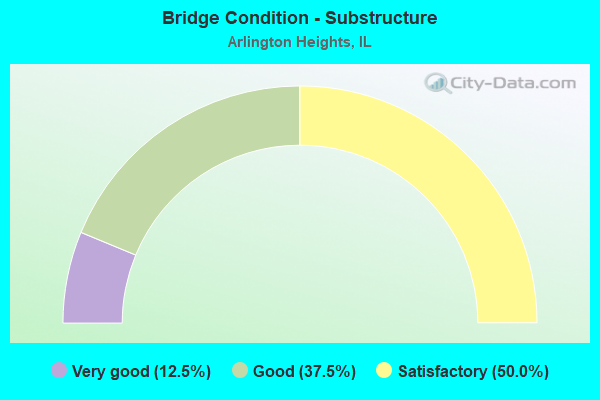
- Bridge Condition - Substructure
- 12.5%Very good
- 37.5%Good
- 50.0%Satisfactory
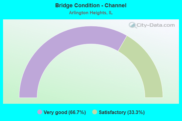
- Bridge Condition - Channel
- 66.7%Very good
- 33.3%Satisfactory
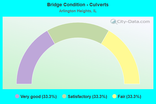
- Bridge Condition - Culverts
- 33.3%Very good
- 33.3%Satisfactory
- 33.3%Fair
Find on map >> Show street view
Structure Number: 33307, Location: 3.0M NW GREENVILLE (Lat: 38.930719, Lng: -89.456217), Route carried "on" structure: County highway , Year Built: 1982, Status: Open, Structure Length: 0.68m (2.23ft), Average Daily Traffic: 100 (year 2020), Truck Traffic: 15%, Average Future Daily Traffic: 158 (year 2032), Features Intersected: INDIAN CREEK, Facility Carried by Structure: TR 101A
Minimum Vertical Clearance: 30+ m (98+ ft), Kilometerpoint: 5.118, Lanes on structure: 2, Owner: Town or Township Highway Agency, Approaching Roadway Width: 6.7m (22.0ft), Material/Design: Steel, Design/Construction: Culvert, Number Of Spans In Main Unit: 2, Length of Maximum Span: 3.0m (9.8ft)
Condition: Channel: Satisfactory, Culverts: Satisfactory, Operating Rating: 40.5 metric tons, Method Used To Determine Operating Rating: Field evaluation and documented engineering judgment, Inventory Rating: 24.3 metric tons, Method Used To Determine Inventory Rating: Field evaluation and documented engineering judgment, Structural Evaluation: Equal to present minimum criteria, Waterway Adequacy: Equal to present desirable criteria, Approach Roadway Alignment: Equal to present desirable criteria, Designated Inspection Frequency: Every 24 months, Inspection Date: December 2021
Find on map >> Show street view
Structure Number: 160371, Location: 0.5 M S IL 68 (Lat: 42.129697, Lng: -88.004956), Route carried "on" structure: State highway 53, Year Built: 1965, Year Reconstructed: 1991, Status: Open, Structure Length: 6.82m (22.38ft), Average Daily Traffic: 77,600 (year 2021), Truck Traffic: 7%, Average Future Daily Traffic: 60,616 (year 2032), Design Load: HS 20, Features Intersected: US 12 (RAND RD)
Minimum Vertical Clearance: 30+ m (98+ ft), Kilometerpoint: 120.698, Lanes on structure: 3, Lanes under structure: 4, Base Highway Network: Yes, Owner: State Highway Agency, Approaching Roadway Width: 15.2m (49.9ft), Skew: 3 degrees, Material/Design: Prestressed concrete continuous, Design/Construction: Stringer/Multi-beam, Number Of Spans In Main Unit: 4, Length of Maximum Span: 17.4m (57.1ft), Curb-To-Curb Width: 16.5m (54.1ft), Out-to-Out Width: 17.7m (58.1ft)
Condition: Deck: Fair, Superstructure: Satisfactory, Substructure: Satisfactory, Operating Rating: 76.5 metric tons, Method Used To Determine Operating Rating: Load Factor (LF) rating reported by rating factor (RF) method using MS18 loading, Inventory Rating: 46.0 metric tons, Method Used To Determine Inventory Rating: Load Factor (LF) rating reported by rating factor (RF) method using MS18 loading, Structural Evaluation: Equal to present minimum criteria, Deck Geometry: Equal to present minimum criteria, Underclear: High priority of corrective action, Approach Roadway Alignment: Equal to present desirable criteria, Designated Inspection Frequency: Every 24 months, Inspection Date: October 2020, Deck Structure Type: Concrete Cast-file-Place, Wearing Surface/Protective System: Wearing Surface: Other
Find on map >> Show street view
Structure Number: 160372, Location: 1 M S US 12 (Lat: 42.116453, Lng: -88.003939), Route carried "on" structure: State highway 53, Year Built: 1965, Status: Open, Structure Length: 1.59m (5.22ft), Average Daily Traffic: 85,500 (year 2021), Truck Traffic: 6%, Average Future Daily Traffic: 141,110 (year 2032), Design Load: HS 20, Features Intersected: Anderson Dr MS 3240
Minimum Vertical Clearance: 30+ m (98+ ft), Kilometerpoint: 119.249, Lanes on structure: 6, Lanes under structure: 2, Base Highway Network: Yes, Owner: State Highway Agency, Approaching Roadway Width: 35.4m (116.1ft), Skew: 30 degrees, Material/Design: Prestressed concrete, Design/Construction: Stringer/Multi-beam, Number Of Spans In Main Unit: 1, Length of Maximum Span: 14.3m (46.9ft), Curb-To-Curb Width: 35.4m (116.1ft), Out-to-Out Width: 37.2m (122.0ft)
Condition: Deck: Poor, Superstructure: Satisfactory, Substructure: Satisfactory, Operating Rating: 43.7 metric tons, Method Used To Determine Operating Rating: Load Factor (LF) rating reported by rating factor (RF) method using MS18 loading, Inventory Rating: 26.2 metric tons, Method Used To Determine Inventory Rating: Load Factor (LF) rating reported by rating factor (RF) method using MS18 loading, Structural Evaluation: Equal to present minimum criteria, Deck Geometry: Superior to present desirable criteria, Underclear: Meets minimum limits, Approach Roadway Alignment: Equal to present desirable criteria, Designated Inspection Frequency: Every 24 months, Inspection Date: Febuary 2021, Deck Structure Type: Concrete Cast-file-Place, Wearing Surface/Protective System: Wearing Surface: Other
Find on map >> Show street view
Structure Number: 160373, Location: 1.9 S IL 68 (Lat: 42.109919, Lng: -88.003472), Route carried "on" structure: State highway 53, Year Built: 1964, Year Reconstructed: 1991, Status: Open, Structure Length: 7.62m (25.00ft), Average Daily Traffic: 92,900 (year 2021), Truck Traffic: 6%, Average Future Daily Traffic: 73,542 (year 2032), Design Load: HS 20, Features Intersected: PALATINE RD
Minimum Vertical Clearance: 30+ m (98+ ft), Kilometerpoint: 118.557, Lanes on structure: 4, Lanes under structure: 6, Base Highway Network: Yes, Owner: State Highway Agency, Approaching Roadway Width: 18.3m (60.0ft), Skew: 1 degrees, Material/Design: Steel continuous, Design/Construction: Stringer/Multi-beam, Number Of Spans In Main Unit: 4, Length of Maximum Span: 18.5m (60.7ft), Curb-To-Curb Width: 20.3m (66.6ft), Out-to-Out Width: 21.3m (69.9ft)
Condition: Deck: Poor, Superstructure: Fair, Substructure: Satisfactory, Operating Rating: 50.2 metric tons, Method Used To Determine Operating Rating: Load Factor (LF) rating reported by rating factor (RF) method using MS18 loading, Inventory Rating: 30.1 metric tons, Method Used To Determine Inventory Rating: Load Factor (LF) rating reported by rating factor (RF) method using MS18 loading, Structural Evaluation: Somewhat better than minimum adequacy, Deck Geometry: Equal to present minimum criteria, Underclear: Meets minimum limits, Approach Roadway Alignment: Equal to present desirable criteria, Designated Inspection Frequency: Every 24 months, Inspection Date: January 2021, Deck Structure Type: Concrete Cast-file-Place, Wearing Surface/Protective System: Wearing Surface: Other
Find on map >> Show street view
Structure Number: 160961, Location: 0.8 M E US 12 (Lat: 42.139142, Lng: -88.005233), Route carried "on" structure: State highway 68, Year Built: 1969, Year Reconstructed: 1985, Status: Open, Structure Length: 7.80m (25.59ft), Average Daily Traffic: 26,300 (year 2021), Truck Traffic: 3%, Average Future Daily Traffic: 29,664 (year 2032), Design Load: HS 20, Features Intersected: IL 53
Minimum Vertical Clearance: 30+ m (98+ ft), Kilometerpoint: 23.238, Lanes on structure: 4, Lanes under structure: 6, Base Highway Network: Yes, Owner: State Highway Agency, Approaching Roadway Width: 25.3m (83.0ft), Skew: 30 degrees, Material/Design: Steel continuous, Design/Construction: Stringer/Multi-beam, Number Of Spans In Main Unit: 4, Length of Maximum Span: 25.6m (84.0ft), Curb-To-Curb Width: 20.1m (65.9ft), Out-to-Out Width: 26.8m (87.9ft)
Condition: Deck: Satisfactory, Superstructure: Satisfactory, Substructure: Good, Operating Rating: 82.3 metric tons, Method Used To Determine Operating Rating: Load Factor (LF) rating reported by rating factor (RF) method using MS18 loading, Inventory Rating: 49.2 metric tons, Method Used To Determine Inventory Rating: Load Factor (LF) rating reported by rating factor (RF) method using MS18 loading, Structural Evaluation: Equal to present minimum criteria, Deck Geometry: Better than present minimum criteria, Underclear: High priority of corrective action, Approach Roadway Alignment: Equal to present desirable criteria, Designated Inspection Frequency: Every 24 months, Inspection Date: July 2021, Deck Structure Type: Concrete Cast-file-Place, Wearing Surface/Protective System: Wearing Surface: Other
Find on map >> Show street view
Structure Number: 16097, Location: 1.5 M S US 12 (Lat: 42.110086, Lng: -88.003411), Route carried "on" structure: State highway 53, Year Built: 1964, Status: Open, Structure Length: 6.15m (20.18ft), Average Daily Traffic: 93,700 (year 2021), Truck Traffic: 6%, Average Future Daily Traffic: 73,542 (year 2032), Design Load: HS 20, Features Intersected: PALATINE RD
Minimum Vertical Clearance: 30+ m (98+ ft), Kilometerpoint: 118.573, Lanes on structure: 4, Lanes under structure: 6, Base Highway Network: Yes, Owner: State Highway Agency, Approaching Roadway Width: 18.3m (60.0ft), Skew: 1 degrees, Material/Design: Steel continuous, Design/Construction: Stringer/Multi-beam, Number Of Spans In Main Unit: 4, Length of Maximum Span: 18.5m (60.7ft), Curb-To-Curb Width: 20.1m (65.9ft), Out-to-Out Width: 21.1m (69.2ft)
Condition: Deck: Poor, Superstructure: Fair, Substructure: Satisfactory, Operating Rating: 51.2 metric tons, Method Used To Determine Operating Rating: Load Factor (LF) rating reported by rating factor (RF) method using MS18 loading, Inventory Rating: 30.1 metric tons, Method Used To Determine Inventory Rating: Load Factor (LF) rating reported by rating factor (RF) method using MS18 loading, Structural Evaluation: Somewhat better than minimum adequacy, Deck Geometry: Equal to present minimum criteria, Underclear: Meets minimum limits, Approach Roadway Alignment: Equal to present desirable criteria, Designated Inspection Frequency: Every 24 months, Inspection Date: January 2021, Deck Structure Type: Concrete Cast-file-Place, Wearing Surface/Protective System: Wearing Surface: Other
Find on map >> Show street view
Structure Number: 160973, Location: 0.6 M S IL 68 (Lat: 42.129550, Lng: -88.004958), Route carried "on" structure: State highway 53, Year Built: 1965, Year Reconstructed: 1987, Status: Open, Structure Length: 6.80m (22.31ft), Average Daily Traffic: 77,600 (year 2021), Truck Traffic: 7%, Average Future Daily Traffic: 60,616 (year 2032), Design Load: HS 20, Features Intersected: US 12 (RAND ROAD)
Minimum Vertical Clearance: 30+ m (98+ ft), Kilometerpoint: 120.681, Lanes on structure: 3, Lanes under structure: 4, Base Highway Network: Yes, Owner: State Highway Agency, Approaching Roadway Width: 17.1m (56.1ft), Skew: 3 degrees, Material/Design: Prestressed concrete continuous, Design/Construction: Stringer/Multi-beam, Number Of Spans In Main Unit: 4, Length of Maximum Span: 17.1m (56.1ft), Curb-To-Curb Width: 16.5m (54.1ft), Out-to-Out Width: 17.4m (57.1ft)
Condition: Deck: Poor, Superstructure: Satisfactory, Substructure: Good, Operating Rating: 76.5 metric tons, Method Used To Determine Operating Rating: Load Factor (LF) rating reported by rating factor (RF) method using MS18 loading, Inventory Rating: 46.0 metric tons, Method Used To Determine Inventory Rating: Load Factor (LF) rating reported by rating factor (RF) method using MS18 loading, Structural Evaluation: Equal to present minimum criteria, Deck Geometry: Equal to present minimum criteria, Underclear: High priority of corrective action, Approach Roadway Alignment: Equal to present desirable criteria, Designated Inspection Frequency: Every 24 months, Inspection Date: October 2020, Deck Structure Type: Concrete Cast-file-Place, Wearing Surface/Protective System: Wearing Surface: Other
Find on map >> Show street view
Structure Number: 162706, Location: 0.5 Mi NW of Ill. 83 (Lat: 42.037742, Lng: -87.977833), Route carried "on" structure: Interstate 90, Year Built: 2016, Status: Open, Structure Length: 1.03m (3.38ft), Average Daily Traffic: 121,100 (year 2021), Truck Traffic: 9%, Average Future Daily Traffic: 129,986 (year 2032), Design Load: HS 25 or greater, Features Intersected: Stream
Minimum Vertical Clearance: 30+ m (98+ ft), Kilometerpoint: 114.727, Lanes on structure: 10, Base Highway Network: Yes, Toll: On toll road, Owner: State Toll Authority, Approaching Roadway Width: 27.8m (91.2ft), Skew: 3 degrees, Material/Design: Concrete, Design/Construction: Culvert, Number Of Spans In Main Unit: 2, Length of Maximum Span: 3.7m (12.1ft)
Condition: Channel: Very good, Culverts: Very good, Operating Rating: 97.2 metric tons, Method Used To Determine Operating Rating: Load and Resistance Factor Rating (LRFR) rating reported by rating factor(RF) method using HL-93 loadings, Inventory Rating: 97.2 metric tons, Method Used To Determine Inventory Rating: Load and Resistance Factor Rating (LRFR) rating reported by rating factor(RF) method using HL-93 loadings, Structural Evaluation: Equal to present desirable criteria, Waterway Adequacy: Superior to present desirable criteria, Approach Roadway Alignment: Equal to present desirable criteria, Designated Inspection Frequency: Every 24 months, Inspection Date: August 2019
Find on map >> Show street view
Structure Number: 164011, Location: 0.7 W ARL HTS P25 (Lat: 42.153583, Lng: -87.996656), Route carried "on" structure: Other road , Year Built: 1978, Status: Open, Structure Length: 1.38m (4.53ft), Average Daily Traffic: 49,900 (year 2018), Truck Traffic: 6%, Average Future Daily Traffic: 47,792 (year 2032), Design Load: HS 20+Mod, Features Intersected: TRIB OF BUFFALO CR, Facility Carried by Structure: LAKE COOK RD
Minimum Vertical Clearance: 30+ m (98+ ft), Kilometerpoint: 3.476, Lanes on structure: 4, Base Highway Network: Yes, Owner: County Highway Agency, Approaching Roadway Width: 20.4m (66.9ft), Skew: 22 degrees, Material/Design: Concrete, Design/Construction: Culvert, Number Of Spans In Main Unit: 3, Length of Maximum Span: 4.5m (14.8ft), Curb or Sidewalk Widths: Left: 0.0m, Right: 1.2m (3.9ft)
Condition: Channel: Very good, Culverts: Fair, Operating Rating: 59.9 metric tons, Method Used To Determine Operating Rating: Load Factor (LF) rating reported by rating factor (RF) method using MS18 loading, Inventory Rating: 36.0 metric tons, Method Used To Determine Inventory Rating: Load Factor (LF) rating reported by rating factor (RF) method using MS18 loading, Structural Evaluation: Somewhat better than minimum adequacy, Waterway Adequacy: Better than present minimum criteria, Approach Roadway Alignment: Superior to present desirable criteria, Designated Inspection Frequency: Every 24 months, Inspection Date: September 2021
Find on map >> Show street view
Structure Number: 169866, Location: 1.4 M SE ILL 58 P5 (Lat: 42.040544, Lng: -87.983783), Route carried "on" structure: Interstate 90, Year Built: 1958, Year Reconstructed: 1969, Status: Open, Structure Length: 5.00m (16.40ft), Average Daily Traffic: 121,100 (year 2021), Truck Traffic: 9%, Average Future Daily Traffic: 64,993 (year 2032), Design Load: HS 20, Features Intersected: ARLINGTON HTS RD
Minimum Vertical Clearance: 30+ m (98+ ft), Kilometerpoint: 114.051, Lanes on structure: 5, Lanes under structure: 4, Base Highway Network: Yes, Toll: On toll road, Owner: State Toll Authority, Approaching Roadway Width: 32.5m (106.6ft), Skew: 2 degrees, Material/Design: Prestressed concrete, Design/Construction: Stringer/Multi-beam, Number Of Spans In Main Unit: 2, Length of Maximum Span: 22.9m (75.1ft), Curb-To-Curb Width: 32.5m (106.6ft), Out-to-Out Width: 34.3m (112.5ft)
Condition: Deck: Good, Superstructure: Good, Substructure: Very good, Operating Rating: 68.4 metric tons, Method Used To Determine Operating Rating: Load and Resistance Factor Rating (LRFR) rating reported by rating factor(RF) method using HL-93 loadings, Inventory Rating: 38.9 metric tons, Method Used To Determine Inventory Rating: Load and Resistance Factor Rating (LRFR) rating reported by rating factor(RF) method using HL-93 loadings, Structural Evaluation: Better than present minimum criteria, Deck Geometry: Superior to present desirable criteria, Underclear: Meets minimum limits, Approach Roadway Alignment: Equal to present desirable criteria, Designated Inspection Frequency: Every 24 months, Inspection Date: August 2019, Deck Structure Type: Concrete Cast-file-Place, Wearing Surface/Protective System: Deck Protection: Epoxy Coated Reinforcing
Find on map >> Show street view
Structure Number: 169972, Location: I90 & ARLGTN HTS P5 (Lat: 42.040442, Lng: -87.983550), Route carried "on" structure: Interstate 90, Year Built: 1958, Year Reconstructed: 1969, Status: Open, Structure Length: 5.79m (19.00ft), Average Daily Traffic: 121,100 (year 2021), Truck Traffic: 9%, Average Future Daily Traffic: 64,993 (year 2032), Design Load: HS 20, Features Intersected: ARLINGTON HTS RD
Minimum Vertical Clearance: 30+ m (98+ ft), Kilometerpoint: 114.083, Lanes on structure: 4, Lanes under structure: 4, Base Highway Network: Yes, Toll: On toll road, Owner: State Toll Authority, Approaching Roadway Width: 29.1m (95.5ft), Skew: 2 degrees, Material/Design: Prestressed concrete, Design/Construction: Stringer/Multi-beam, Number Of Spans In Main Unit: 3, Length of Maximum Span: 22.9m (75.1ft), Curb-To-Curb Width: 29.1m (95.5ft), Out-to-Out Width: 30.1m (98.8ft)
Condition: Deck: Good, Superstructure: Good, Substructure: Good, Operating Rating: 68.4 metric tons, Method Used To Determine Operating Rating: Load and Resistance Factor Rating (LRFR) rating reported by rating factor(RF) method using HL-93 loadings, Inventory Rating: 40.2 metric tons, Method Used To Determine Inventory Rating: Load and Resistance Factor Rating (LRFR) rating reported by rating factor(RF) method using HL-93 loadings, Structural Evaluation: Better than present minimum criteria, Deck Geometry: Superior to present desirable criteria, Underclear: Meets minimum limits, Approach Roadway Alignment: Equal to present desirable criteria, Designated Inspection Frequency: Every 24 months, Inspection Date: August 2019, Deck Structure Type: Concrete Cast-file-Place, Wearing Surface/Protective System: Deck Protection: Epoxy Coated Reinforcing
Find on map >> Show street view
Structure Number: 160371, Location: 0.5 M S IL 68 (Lat: 42.129764, Lng: -88.005044), Route carried "under" structure: US 12, Year Built: 1965, Structure Length: 0. m, Average Daily Traffic: 28,900 (year 2019), Truck Traffic: 4%, Features Intersected: US 12 (RAND RD), Facility Carried by Structure: IL 53 SB
Minimum Vertical Clearance: 4.70m (15.42ft), Kilometerpoint: 54.909, Lanes on structure: 3, Lanes under structure: 4, Material/Design: Prestressed concrete continuous, Design/Construction: Stringer/Multi-beam, Length of Maximum Span: 17.4m (57.1ft)
Find on map >> Show street view
Structure Number: 160372, Location: 1 M S US 12 (Lat: 42.116308, Lng: -88.003908), Route carried "under" structure: City street , Year Built: 1965, Structure Length: 0. m, Average Daily Traffic: 1,800 (year 2018), Truck Traffic: 4%, Features Intersected: Anderson Dr MS 3240, Facility Carried by Structure: IL 53 FAP 342
Minimum Vertical Clearance: 4.57m (14.99ft), Kilometerpoint: 1.641, Lanes on structure: 6, Lanes under structure: 2, Material/Design: Prestressed concrete, Design/Construction: Stringer/Multi-beam, Length of Maximum Span: 14.3m (46.9ft)
Find on map >> Show street view
Structure Number: 160373, Location: 1.9 S IL 68 (Lat: 42.110086, Lng: -88.003411), Route carried "under" structure: Other road , Year Built: 1964, Structure Length: 0. m, Average Daily Traffic: 37,600 (year 2021), Truck Traffic: 5%, Features Intersected: PALATINE RD, Facility Carried by Structure: IL 53 NB
Minimum Vertical Clearance: 4.62m (15.16ft), Kilometerpoint: 12.520, Lanes on structure: 4, Lanes under structure: 6, Material/Design: Steel continuous, Design/Construction: Stringer/Multi-beam, Length of Maximum Span: 18.5m (60.7ft)
Find on map >> Show street view
Structure Number: 160961, Location: 0.8 M E US 12 (Lat: 42.139142, Lng: -88.005233), Route carried "under" structure: State highway 53, Year Built: 1969, Structure Length: 0. m, Average Daily Traffic: 63,400 (year 2021), Truck Traffic: 7%, Features Intersected: IL 53, Facility Carried by Structure: IL 68 (DUNDEE RD)
Minimum Vertical Clearance: 4.57m (14.99ft), Kilometerpoint: 121.776, Lanes on structure: 4, Lanes under structure: 6, Material/Design: Steel continuous, Design/Construction: Stringer/Multi-beam, Length of Maximum Span: 25.6m (84.0ft)
Find on map >> Show street view
Structure Number: 16097, Location: 1.5 M S US 12 (Lat: 42.110089, Lng: -88.003542), Route carried "under" structure: Other road , Year Built: 1964, Structure Length: 0. m, Average Daily Traffic: 15,700 (year 2021), Truck Traffic: 3%, Features Intersected: PALATINE RD, Facility Carried by Structure: IL 53 SB
Minimum Vertical Clearance: 4.62m (15.16ft), Kilometerpoint: 12.504, Lanes on structure: 4, Lanes under structure: 6, Material/Design: Steel continuous, Design/Construction: Stringer/Multi-beam, Length of Maximum Span: 18.5m (60.7ft)
Find on map >> Show street view
Structure Number: 160973, Location: 0.6 M S IL 68 (Lat: 42.129522, Lng: -88.004719), Route carried "under" structure: US 12, Year Built: 1965, Structure Length: 0. m, Average Daily Traffic: 24,200 (year 2021), Truck Traffic: 3%, Features Intersected: US 12 (RAND ROAD), Facility Carried by Structure: IL 53 NB
Minimum Vertical Clearance: 4.45m (14.60ft), Kilometerpoint: 54.974, Lanes on structure: 3, Lanes under structure: 4, Material/Design: Prestressed concrete continuous, Design/Construction: Stringer/Multi-beam, Length of Maximum Span: 17.1m (56.1ft)
Find on map >> Show street view
Structure Number: 169866, Location: 1.4 M SE ILL 58 P5 (Lat: 42.039914, Lng: -87.983911), Route carried "under" structure: Other road , Year Built: 1958, Structure Length: 0. m, Average Daily Traffic: 27,100 (year 2021), Truck Traffic: 5%, Features Intersected: ARLINGTON HTS RD, Facility Carried by Structure: I90 WB Jayne Adams
Minimum Vertical Clearance: 4.47m (14.67ft), Kilometerpoint: 12.842, Lanes on structure: 5, Lanes under structure: 4, Toll: On toll road, Material/Design: Prestressed concrete, Design/Construction: Stringer/Multi-beam, Length of Maximum Span: 22.9m (75.1ft)
Find on map >> Show street view
Structure Number: 169972, Location: I90 & ARLGTN HTS P5 (Lat: 42.039594, Lng: -87.983978), Route carried "under" structure: Other road , Year Built: 1958, Structure Length: 0. m, Average Daily Traffic: 27,100 (year 2021), Truck Traffic: 5%, Features Intersected: ARLINGTON HTS RD, Facility Carried by Structure: I90 EB (NW TOLL)
Minimum Vertical Clearance: 4.47m (14.67ft), Kilometerpoint: 12.874, Lanes on structure: 4, Lanes under structure: 4, Toll: On toll road, Material/Design: Prestressed concrete, Design/Construction: Stringer/Multi-beam, Length of Maximum Span: 22.9m (75.1ft)