Bridge Statistics for Ashland, Kentucky (KY)
Condition, Traffic, Stress, Structural Evaluation, Project Costs
- National Bridge Inventory (NBI) Statistics
- 19Number of bridges
- 679ft / 207mTotal length
- $18,313,000Total costs
- 95,151Total average daily traffic
- 6,608Total average daily truck traffic
- National Bridge Inventory (NBI) Registered Bridges for Ashland
- No street view available for this location
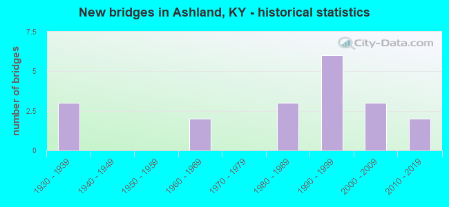
- New bridges - historical statistics
- 31930-1939
- 21960-1969
- 31980-1989
- 61990-1999
- 32000-2009
- 22010-2019


- Bridge Condition - Deck
- 42.9%Good
- 57.1%Satisfactory

- Bridge Condition - Superstructure
- 57.1%Good
- 28.6%Satisfactory
- 14.3%Fair

- Bridge Condition - Substructure
- 14.3%Very good
- 14.3%Good
- 71.4%Satisfactory

- Bridge Condition - Channel
- 28.6%Very good
- 57.1%Good
- 14.3%Fair

- Bridge Condition - Culverts
- 50.0%Good
- 50.0%Satisfactory
Find on map >> Show street view
Structure Number: 10B00038L, Location: SBL 1.1 MI SE OF JCT KY 5 (Lat: 38.486389, Lng: -82.655833), Route carried "on" structure: US 23, Year Built: 1965, Status: Open, Structure Length: 33.04m (108.40ft), Average Daily Traffic: 10,795 (year 2020), Truck Traffic: 6%, Average Future Daily Traffic: 10,147 (year 2040), Design Load: HS 20, Features Intersected: CSX RR & ARMCO RD, Facility Carried by Structure: WALNUT ST / WINCHE
Minimum Vertical Clearance: 30+ m (98+ ft), Kilometerpoint: 31.250, Lanes on structure: 2, Lanes under structure: 2, Base Highway Network: Yes, Owner: State Highway Agency, Approaching Roadway Width: 11.0m (36.1ft), Skew: 4 degrees, Material/Design: Steel continuous, Design/Construction: Stringer/Multi-beam, Number Of Spans In Main Unit: 3, Number Of Approach Spans: 7, Length of Maximum Span: 59.4m (194.9ft), Curb-To-Curb Width: 10.1m (33.1ft), Out-to-Out Width: 11.0m (36.1ft)
Condition: Deck: Satisfactory, Superstructure: Satisfactory, Substructure: Satisfactory, Operating Rating: 62.6 metric tons, Method Used To Determine Operating Rating: Load Factor (LF), Inventory Rating: 37.2 metric tons, Method Used To Determine Inventory Rating: Load Factor (LF), Structural Evaluation: Equal to present minimum criteria, Deck Geometry: Somewhat better than minimum adequacy, Underclear: Superior to present desirable criteria, Approach Roadway Alignment: Equal to present desirable criteria, Length Of Structure Improvement: 3.30m (10.83ft), Designated Inspection Frequency: Every 24 months, Inspection Date: October 2021, Bridge Improvement Cost: $4,878,000, Total Project Cost: $4,878,000, Deck Structure Type: Concrete Cast-file-Place, Wearing Surface/Protective System: Wearing Surface: Monolithic Concrete
Find on map >> Show street view
Structure Number: 10B00040N, Location: OHIO RIVER BRIDGE-ASHLAND (Lat: 38.484167, Lng: -82.641389), Route carried "on" structure: Spur US 23, Year Built: 1930, Year Reconstructed: 1986, Status: Posted for load, Structure Length: 69.43m (227.79ft), Average Daily Traffic: 11,984 (year 2019), Truck Traffic: 9%, Average Future Daily Traffic: 11,264 (year 2039), Design Load: H 15, Features Intersected: OHIO RIVER,CSX ,STREETS
Minimum Vertical Clearance: 4.57m (14.99ft), Kilometerpoint: 0.476, Lanes on structure: 3, Lanes under structure: 5, Base Highway Network: Yes, Owner: State Highway Agency, Approaching Roadway Width: 8.5m (27.9ft), Navigation Control: Yes ( Vertical Clearance: 21.3m (69.9ft), Horizontal Clearance: 220.1m (722.1ft)), Material/Design: Steel, Design/Construction: Truss - Thru, Number Of Spans In Main Unit: 5, Number Of Approach Spans: 10, Length of Maximum Span: 225.2m (738.8ft), Curb or Sidewalk Widths: Left: 0.0m, Right: 1.5m (4.9ft), Curb-To-Curb Width: 7.6m (24.9ft), Out-to-Out Width: 8.5m (27.9ft)
Condition: Deck: Satisfactory, Superstructure: Fair, Substructure: Satisfactory, Channel: Very good, Operating Rating: 45.2 metric tons, Method Used To Determine Operating Rating: Load Factor (LF), Inventory Rating: 27.1 metric tons, Method Used To Determine Inventory Rating: Load Factor (LF), Structural Evaluation: Somewhat better than minimum adequacy, Deck Geometry: High priority of replacement, Underclear: High priority of replacement, Waterway Adequacy: Equal to present desirable criteria, Approach Roadway Alignment: Equal to present minimum criteria, Bridge Posting: Required (Relationship of Operating Rating to Maximum Legal Load: > 39.9% below), Length Of Structure Improvement: 6.94m (22.77ft), Designated Inspection Frequency: Every 24 months, Critical Feature Inspection Frequency: Every 24 months, Underwater Inspection Frequency: Every 60 months, Inspection Date: September 2021, Critical Feature Inspection Date: September 2021, Underwater Inspection Date: December 2020, Bridge Improvement Cost: $9,397,000, Total Project Cost: $9,396,000, Deck Structure Type: Concrete Cast-file-Place, Wearing Surface/Protective System: Wearing Surface: Monolithic Concrete, Membrane: Epoxy, Deck Protection: Other
Find on map >> Show street view
Structure Number: 10B00058N, Location: N-BOUND 23 SPUR OVR OHIO (Lat: 38.483611, Lng: -82.640556), Route carried "on" structure: Spur US 23, Year Built: 1985, Status: Posted for load, Structure Length: 70.56m (231.50ft), Average Daily Traffic: 11,984 (year 2019), Truck Traffic: 9%, Average Future Daily Traffic: 11,264 (year 2039), Design Load: HS 20, Features Intersected: OHIO RIVER,CSX,STREETS
Minimum Vertical Clearance: 5.54m (18.18ft), Kilometerpoint: 0.410, Lanes on structure: 3, Lanes under structure: 5, Base Highway Network: Yes, Owner: State Highway Agency, Approaching Roadway Width: 13.4m (44.0ft), Navigation Control: Yes ( Vertical Clearance: 23.9m (78.4ft), Horizontal Clearance: 220.1m (722.1ft)), Material/Design: Steel, Design/Construction: Truss - Thru, Number Of Spans In Main Unit: 3, Number Of Approach Spans: 6, Length of Maximum Span: 225.6m (740.2ft), Curb-To-Curb Width: 13.4m (44.0ft), Out-to-Out Width: 14.4m (47.2ft)
Condition: Deck: Satisfactory, Superstructure: Satisfactory, Substructure: Satisfactory, Channel: Good, Operating Rating: 42.7 metric tons, Method Used To Determine Operating Rating: Load Factor (LF), Inventory Rating: 25.6 metric tons, Method Used To Determine Inventory Rating: Load Factor (LF), Structural Evaluation: Equal to present minimum criteria, Deck Geometry: Somewhat better than minimum adequacy, Underclear: High priority of corrective action, Waterway Adequacy: Equal to present desirable criteria, Approach Roadway Alignment: Equal to present minimum criteria, Bridge Posting: Required (Relationship of Operating Rating to Maximum Legal Load: 30.0 - 39.9% below), Designated Inspection Frequency: Every 24 months, Critical Feature Inspection Frequency: Every 24 months, Underwater Inspection Frequency: Every 60 months, Inspection Date: September 2021, Critical Feature Inspection Date: September 2021, Underwater Inspection Date: December 2020, Deck Structure Type: Concrete Cast-file-Place, Wearing Surface/Protective System: Wearing Surface: Monolithic Concrete
Find on map >> Show street view
Structure Number: 10B00063R, Location: .11 MI S - NLL -ASHLAND (Lat: 38.486667, Lng: -82.656111), Route carried "on" structure: US 23, Year Built: 1990, Status: Open, Structure Length: 28.77m (94.39ft), Average Daily Traffic: 10,795 (year 2020), Truck Traffic: 6%, Average Future Daily Traffic: 10,147 (year 2040), Design Load: HS 25 or greater, Features Intersected: CSX RAILROAD
Minimum Vertical Clearance: 30+ m (98+ ft), Kilometerpoint: 31.271, Lanes on structure: 2, Lanes under structure: 2, Base Highway Network: Yes, Owner: State Highway Agency, Approaching Roadway Width: 9.8m (32.2ft), Skew: 4 degrees, Material/Design: Prestressed concrete continuous, Design/Construction: Stringer/Multi-beam, Number Of Spans In Main Unit: 9, Length of Maximum Span: 36.6m (120.1ft), Curb-To-Curb Width: 9.1m (29.9ft), Out-to-Out Width: 10.1m (33.1ft)
Condition: Deck: Satisfactory, Superstructure: Good, Substructure: Good, Operating Rating: 88.3 metric tons, Method Used To Determine Operating Rating: Load Factor (LF), Inventory Rating: 53.0 metric tons, Method Used To Determine Inventory Rating: Load Factor (LF), Structural Evaluation: Better than present minimum criteria, Deck Geometry: Meets minimum limits, Underclear: Superior to present desirable criteria, Approach Roadway Alignment: Equal to present desirable criteria, Length Of Structure Improvement: 2.88m (9.45ft), Designated Inspection Frequency: Every 24 months, Inspection Date: October 2021, Bridge Improvement Cost: $3,929,000, Total Project Cost: $3,929,000, Deck Structure Type: Concrete Cast-file-Place, Wearing Surface/Protective System: Wearing Surface: Monolithic Concrete
Find on map >> Show street view
Structure Number: 10B00065N, Location: 200 FT SE JCT KY 766 (Lat: 38.455556, Lng: -82.677778), Route carried "on" structure: State highway 1134, Year Built: 1999, Status: Open, Structure Length: 0.64m (2.10ft), Average Daily Traffic: 3,149 (year 2020), Truck Traffic: 4%, Average Future Daily Traffic: 2,928 (year 2040), Features Intersected: LITTLE HOOD CREEK, Facility Carried by Structure: WINSLOW-SUMMIT ROA
Minimum Vertical Clearance: 30+ m (98+ ft), Kilometerpoint: 0.998, Lanes on structure: 2, Owner: State Highway Agency, Approaching Roadway Width: 8.5m (27.9ft), Material/Design: Aluminum, Iron, Design/Construction: Culvert, Number Of Spans In Main Unit: 1, Length of Maximum Span: 6.4m (21.0ft), Curb-To-Curb Width: 6.4m (21.0ft), Out-to-Out Width: 6.4m (21.0ft)
Condition: Channel: Good, Culverts: Satisfactory, Operating Rating: 60.9 metric tons, Method Used To Determine Operating Rating: Load and Resistance Factor Rating (LRFR) rating reported by rating factor(RF) method using HL-93 loadings, Inventory Rating: 47.0 metric tons, Method Used To Determine Inventory Rating: Load and Resistance Factor Rating (LRFR) rating reported by rating factor(RF) method using HL-93 loadings, Structural Evaluation: Equal to present minimum criteria, Deck Geometry: High priority of replacement, Waterway Adequacy: Equal to present desirable criteria, Approach Roadway Alignment: Equal to present desirable criteria, Designated Inspection Frequency: Every 24 months, Inspection Date: October 2021
Find on map >> Show street view
Structure Number: 10B00078N, Location: 2.64 MI NW of JCT US 23 (Lat: 38.436389, Lng: -82.627778), Route carried "on" structure: State highway 168, Year Built: 2013, Status: Posted for load, Structure Length: 0.98m (3.22ft), Average Daily Traffic: 1,865 (year 2019), Truck Traffic: 4%, Average Future Daily Traffic: 1,734 (year 2039), Features Intersected: KEYS CREEK
Minimum Vertical Clearance: 30+ m (98+ ft), Kilometerpoint: 4.281, Lanes on structure: 2, Owner: State Highway Agency, Approaching Roadway Width: 6.7m (22.0ft), Skew: 1 degrees, Material/Design: Concrete, Design/Construction: Culvert, Number Of Spans In Main Unit: 1, Length of Maximum Span: 9.8m (32.2ft)
Condition: Channel: Good, Culverts: Good, Operating Rating: 68.0 metric tons, Method Used To Determine Operating Rating: Load Factor (LF), Inventory Rating: 40.8 metric tons, Method Used To Determine Inventory Rating: Load Factor (LF), Structural Evaluation: Better than present minimum criteria, Waterway Adequacy: Equal to present desirable criteria, Approach Roadway Alignment: Equal to present minimum criteria, Bridge Posting: Required (Relationship of Operating Rating to Maximum Legal Load: > 39.9% below), Designated Inspection Frequency: Every 24 months, Inspection Date: October 2021
Find on map >> Show street view
Structure Number: 10C00002N, Location: .6 MI SW OF JCT KY 168 (Lat: 38.422500, Lng: -82.638056), Route carried "on" structure: County highway 1019, Year Built: 2000, Status: Open, Structure Length: 0.96m (3.15ft), Average Daily Traffic: 560 (year 2009), Average Future Daily Traffic: 487 (year 2029), Design Load: HS 25 or greater, Features Intersected: CATLETTS CREEK, Facility Carried by Structure: CR-1035
Minimum Vertical Clearance: 30+ m (98+ ft), Kilometerpoint: 1.172, Lanes on structure: 2, Owner: County Highway Agency, Approaching Roadway Width: 5.2m (17.1ft), Material/Design: Prestressed concrete, Design/Construction: Box Beam or Girders - Multiple, Number Of Spans In Main Unit: 1, Length of Maximum Span: 7.6m (24.9ft), Curb-To-Curb Width: 5.4m (17.7ft), Out-to-Out Width: 6.1m (20.0ft)
Condition: Deck: Good, Superstructure: Good, Substructure: Satisfactory, Channel: Fair, Operating Rating: 99.8 metric tons, Method Used To Determine Operating Rating: Load Factor (LF), Inventory Rating: 62.8 metric tons, Method Used To Determine Inventory Rating: Load Factor (LF), Structural Evaluation: Equal to present minimum criteria, Deck Geometry: High priority of replacement, Waterway Adequacy: Meets minimum limits, Approach Roadway Alignment: Equal to present minimum criteria, Designated Inspection Frequency: Every 24 months, Inspection Date: January 2021, Deck Structure Type: Concrete Precast Panels, Wearing Surface/Protective System: Wearing Surface: Bituminous
Find on map >> Show street view
Structure Number: 10C00003N, Location: .4 MI SW OF JCT KY 168 (Lat: 38.424444, Lng: -82.636389), Route carried "on" structure: County highway 1019, Year Built: 2000, Status: Open, Structure Length: 0.85m (2.79ft), Average Daily Traffic: 560 (year 2009), Average Future Daily Traffic: 487 (year 2029), Design Load: HS 25 or greater, Features Intersected: CATLETTS CREEK, Facility Carried by Structure: CATLETTS CRK
Minimum Vertical Clearance: 30+ m (98+ ft), Kilometerpoint: 0.892, Lanes on structure: 2, Owner: County Highway Agency, Approaching Roadway Width: 4.9m (16.1ft), Material/Design: Prestressed concrete, Design/Construction: Box Beam or Girders - Multiple, Number Of Spans In Main Unit: 1, Length of Maximum Span: 7.6m (24.9ft), Curb-To-Curb Width: 5.4m (17.7ft), Out-to-Out Width: 6.1m (20.0ft)
Condition: Deck: Good, Superstructure: Good, Substructure: Satisfactory, Channel: Good, Operating Rating: 99.8 metric tons, Method Used To Determine Operating Rating: Load Factor (LF), Inventory Rating: 67.1 metric tons, Method Used To Determine Inventory Rating: Load Factor (LF), Structural Evaluation: Equal to present minimum criteria, Deck Geometry: High priority of replacement, Waterway Adequacy: Equal to present minimum criteria, Approach Roadway Alignment: Equal to present desirable criteria, Length Of Structure Improvement: 0.09m (0.30ft), Designated Inspection Frequency: Every 24 months, Inspection Date: January 2021, Bridge Improvement Cost: $70,000, Roadway Improvement Cost: $40,000, Total Project Cost: $110,000, Deck Structure Type: Concrete Precast Panels, Wearing Surface/Protective System: Wearing Surface: Bituminous
Find on map >> Show street view
Structure Number: 10C00049N, Location: .15 MI. S OF JCT KY 168 (Lat: 38.470278, Lng: -82.671111), Route carried "on" structure: City street 2341, Year Built: 2006, Status: Open, Structure Length: 2.19m (7.19ft), Average Daily Traffic: 4,045 (year 2020), Average Future Daily Traffic: 3,761 (year 2040), Design Load: HS 25 or greater, Features Intersected: LITTLE HOODS CREEK, Facility Carried by Structure: ROBERTS DRIVE
Minimum Vertical Clearance: 30.00m (98.43ft), Kilometerpoint: 0.264, Lanes on structure: 2, Owner: City or Municipal Highway Agency, Approaching Roadway Width: 6.7m (22.0ft), Material/Design: Prestressed concrete, Design/Construction: Box Beam or Girders - Multiple, Number Of Spans In Main Unit: 1, Length of Maximum Span: 20.5m (67.3ft), Curb-To-Curb Width: 6.9m (22.6ft), Out-to-Out Width: 7.3m (24.0ft)
Condition: Deck: Good, Superstructure: Good, Substructure: Very good, Channel: Very good, Operating Rating: 87.6 metric tons, Method Used To Determine Operating Rating: Load Factor (LF), Inventory Rating: 52.6 metric tons, Method Used To Determine Inventory Rating: Load Factor (LF), Structural Evaluation: Better than present minimum criteria, Deck Geometry: High priority of replacement, Waterway Adequacy: Equal to present desirable criteria, Approach Roadway Alignment: Equal to present desirable criteria, Designated Inspection Frequency: Every 24 months, Inspection Date: January 2021, Deck Structure Type: Concrete Cast-file-Place, Wearing Surface/Protective System: Wearing Surface: Monolithic Concrete, Deck Protection: Epoxy Coated Reinforcing
Find on map >> Show street view
Structure Number: 10B00038L, Location: SBL 1.1 MI SE OF JCT KY 5 (Lat: 38.486389, Lng: -82.655833), Route carried "under" structure: Other road 1094, Year Built: 1965, Structure Length: 0. m, Features Intersected: CSX RR & ARMCO RD, Facility Carried by Structure: WALNUT ST / WINCHE
Minimum Vertical Clearance: 6.98m (22.90ft), Kilometerpoint: 0.053, Lanes on structure: 2, Lanes under structure: 2, Material/Design: Steel continuous, Design/Construction: Stringer/Multi-beam, Length of Maximum Span: 59.4m (194.9ft)
Find on map >> Show street view
Structure Number: 10B00040N, Location: OHIO RIVER BRIDGE-ASHLAND (Lat: 38.484167, Lng: -82.641389), Route carried "under" structure: City street 2612, Year Built: 1930, Structure Length: 0. m, Features Intersected: OHIO RIVER,CSX ,STREETS, Facility Carried by Structure: US-23S
Minimum Vertical Clearance: 30+ m (98+ ft), Kilometerpoint: 0.359, Lanes on structure: 3, Lanes under structure: 1, Material/Design: Steel, Design/Construction: Truss - Thru, Length of Maximum Span: 225.2m (738.8ft)
Find on map >> Show street view
Structure Number: 10B00040N, Location: OHIO RIVER BRIDGE-ASHLAND (Lat: 38.484167, Lng: -82.641389), Route carried "under" structure: US 23, Year Built: 1930, Structure Length: 0. m, Average Daily Traffic: 13,079 (year 2018), Truck Traffic: 11%, Features Intersected: OHIO RIVER,CSX ,STREETS
Minimum Vertical Clearance: 30+ m (98+ ft), Kilometerpoint: 29.992, Lanes on structure: 3, Lanes under structure: 4, Material/Design: Steel, Design/Construction: Truss - Thru, Length of Maximum Span: 225.2m (738.8ft)
Find on map >> Show street view
Structure Number: 10B00058N, Location: N-BOUND 23 SPUR OVR OHIO (Lat: 38.483611, Lng: -82.640556), Route carried "under" structure: City street 2612, Year Built: 1985, Structure Length: 0. m, Average Daily Traffic: 2,000 (year 2006), Features Intersected: OHIO RIVER,CSX,STREETS, Facility Carried by Structure: US-23S
Minimum Vertical Clearance: 8.66m (28.41ft), Kilometerpoint: 0.476, Lanes on structure: 3, Lanes under structure: 1, Material/Design: Steel, Design/Construction: Truss - Thru, Length of Maximum Span: 225.6m (740.2ft)
Find on map >> Show street view
Structure Number: 10B00058N, Location: N-BOUND 23 SPUR OVR OHIO (Lat: 38.483611, Lng: -82.640556), Route carried "under" structure: US 23, Year Built: 1985, Structure Length: 0. m, Average Daily Traffic: 13,079 (year 2018), Truck Traffic: 11%, Features Intersected: OHIO RIVER,CSX,STREETS
Minimum Vertical Clearance: 5.49m (18.01ft), Kilometerpoint: 29.874, Lanes on structure: 3, Lanes under structure: 4, Material/Design: Steel, Design/Construction: Truss - Thru, Length of Maximum Span: 225.6m (740.2ft)
Find on map >> Show street view
Structure Number: 10B00063R, Location: .11 MI S - NLL -ASHLAND (Lat: 38.486667, Lng: -82.656111), Route carried "under" structure: Other road 1094, Year Built: 1990, Structure Length: 0. m, Features Intersected: CSX RAILROAD, Facility Carried by Structure: US-23
Minimum Vertical Clearance: 6.58m (21.59ft), Kilometerpoint: 0.032, Lanes on structure: 2, Lanes under structure: 2, Material/Design: Prestressed concrete continuous, Design/Construction: Stringer/Multi-beam, Length of Maximum Span: 36.6m (120.1ft)
Find on map >> Show street view
Structure Number: 10X00100N, Location: 0.371 M S. of jct.KY 2536 (Lat: 38.415278, Lng: -82.598056), Route carried "under" structure: State highway 3294, Year Built: 2010, Structure Length: 0. m, Average Daily Traffic: 2,086 (year 2020), Truck Traffic: 4%, Features Intersected: KY-3294, Facility Carried by Structure: PRISONER PEDWAY
Minimum Vertical Clearance: 4.44m (14.57ft), Kilometerpoint: 13.633, Lanes under structure: 2, Material/Design: Steel, Design/Construction: Stringer/Multi-beam, Length of Maximum Span: 16.1m (52.8ft)
Find on map >> Show street view
Structure Number: 10X00101N, Location: 49' NW Jct of 23rd ST. (Lat: 38.469444, Lng: -82.634444), Route carried "under" structure: City street 2492, Year Built: 1990, Structure Length: 0. m, Average Daily Traffic: 9,170 (year 2018), Features Intersected: Lexington Ave., Facility Carried by Structure: Ped Walk
Minimum Vertical Clearance: 5.03m (16.50ft), Kilometerpoint: 1.379, Lanes under structure: 2, Length of Maximum Span: 15.6m (51.2ft)
Find on map >> Show street view
Structure Number: 10X00102N, Location: 101' S. Jct. Bath St._ (Lat: 38.471111, Lng: -82.633056), Route carried "under" structure: City street 2545, Year Built: 1998, Structure Length: 0. m, Features Intersected: 23rd ST., Facility Carried by Structure: Ped Walk
Minimum Vertical Clearance: 4.62m (15.16ft), Kilometerpoint: 0.690, Lanes under structure: 1, Length of Maximum Span: 16.7m (54.8ft)
Find on map >> Show street view
Structure Number: 10X00103N, Location: 70' N JCT of LEX AVE (Lat: 38.469722, Lng: -82.634167), Route carried "under" structure: City street 2545, Year Built: 1990, Structure Length: 0. m, Features Intersected: 23rd street, Facility Carried by Structure: ped walk way
Minimum Vertical Clearance: 5.51m (18.08ft), Kilometerpoint: 0.864, Lanes under structure: 1, Length of Maximum Span: 16.8m (55.1ft)