Bridge Statistics for Ashley, Indiana (IN)
Condition, Traffic, Stress, Structural Evaluation, Project Costs
- National Bridge Inventory (NBI) Statistics
- 11Number of bridges
- 75ft / 22.9mTotal length
- 104,661Total average daily traffic
- 29,463Total average daily truck traffic
- National Bridge Inventory (NBI) Registered Bridges for Ashley
- No street view available for this location
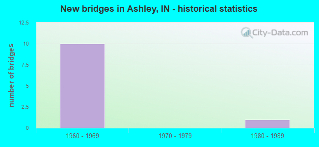
- New bridges - historical statistics
- 101960-1969
- 11980-1989


- Bridge Condition - Deck
- 20.0%Very good
- 20.0%Good
- 40.0%Satisfactory
- 20.0%Fair

- Bridge Condition - Superstructure
- 40.0%Very good
- 60.0%Satisfactory

- Bridge Condition - Substructure
- 40.0%Very good
- 40.0%Satisfactory
- 20.0%Fair
Find on map >> Show street view
Structure Number: 4074, Location: 02.28 S SR 4 (Lat: 41.490700, Lng: -85.054031), Route carried "on" structure: County highway , Year Built: 1963, Status: Open, Structure Length: 6.31m (20.70ft), Average Daily Traffic: 213 (year 2020), Truck Traffic: 10%, Average Future Daily Traffic: 471 (year 2031), Design Load: HS 20, Features Intersected: I-69 NB/SB, Facility Carried by Structure: CR 10
Minimum Vertical Clearance: 30+ m (98+ ft), Kilometerpoint: 0.000, Lanes on structure: 2, Lanes under structure: 4, Owner: State Highway Agency, Approaching Roadway Width: 7.3m (24.0ft), Material/Design: Steel continuous, Design/Construction: Stringer/Multi-beam, Number Of Spans In Main Unit: 2, Number Of Approach Spans: 2, Length of Maximum Span: 20.1m (65.9ft), Curb or Sidewalk Widths: Left: 0.5m (1.6ft), Right: 0.5m (1.6ft), Curb-To-Curb Width: 7.3m (24.0ft), Out-to-Out Width: 8.9m (29.2ft)
Condition: Deck: Fair, Superstructure: Satisfactory, Substructure: Fair, Operating Rating: 48.6 metric tons, Method Used To Determine Operating Rating: Load and Resistance Factor Rating (LRFR) rating reported by rating factor(RF) method using HL-93 loadings, Inventory Rating: 37.6 metric tons, Method Used To Determine Inventory Rating: Load and Resistance Factor Rating (LRFR) rating reported by rating factor(RF) method using HL-93 loadings, Structural Evaluation: Somewhat better than minimum adequacy, Deck Geometry: Somewhat better than minimum adequacy, Underclear: Somewhat better than minimum adequacy, Approach Roadway Alignment: Equal to present desirable criteria, Designated Inspection Frequency: Every 24 months, Inspection Date: March 2021, Deck Structure Type: Concrete Cast-file-Place, Wearing Surface/Protective System: Wearing Surface: Monolithic Concrete
Find on map >> Show street view
Structure Number: 4075, Location: 00.25 N SR 4 (Lat: 41.530739, Lng: -85.055469), Route carried "on" structure: Interstate 69, Year Built: 1963, Year Reconstructed: 2019, Status: Open, Structure Length: 4.72m (15.49ft), Average Daily Traffic: 13,471 (year 2019), Truck Traffic: 29%, Average Future Daily Traffic: 24,093 (year 2030), Design Load: HS 20, Features Intersected: IN NORTHEASTERN RR
Minimum Vertical Clearance: 30+ m (98+ ft), Kilometerpoint: 547.209, Lanes on structure: 3, Base Highway Network: Yes (, Subroute: 1), Owner: State Highway Agency, Approaching Roadway Width: 14.6m (47.9ft), Material/Design: Steel continuous, Design/Construction: Stringer/Multi-beam, Number Of Spans In Main Unit: 3, Length of Maximum Span: 18.3m (60.0ft), Curb-To-Curb Width: 14.9m (48.9ft), Out-to-Out Width: 15.8m (51.8ft)
Condition: Deck: Very good, Superstructure: Very good, Substructure: Very good, Operating Rating: 47.3 metric tons, Method Used To Determine Operating Rating: Load and Resistance Factor Rating (LRFR) rating reported by rating factor(RF) method using HL-93 loadings, Inventory Rating: 36.3 metric tons, Method Used To Determine Inventory Rating: Load and Resistance Factor Rating (LRFR) rating reported by rating factor(RF) method using HL-93 loadings, Structural Evaluation: Equal to present desirable criteria, Deck Geometry: Meets minimum limits, Underclear: Better than present minimum criteria, Approach Roadway Alignment: Equal to present desirable criteria, Designated Inspection Frequency: Every 24 months, Inspection Date: March 2021, Deck Structure Type: Concrete Cast-file-Place, Wearing Surface/Protective System: Wearing Surface: Latex Concrete, Deck Protection: Epoxy Coated Reinforcing
Find on map >> Show street view
Structure Number: 4076, Location: 00.25 N SR 4 (Lat: 41.530750, Lng: -85.055889), Route carried "on" structure: Interstate 69, Year Built: 1963, Year Reconstructed: 2019, Status: Open, Structure Length: 4.72m (15.49ft), Average Daily Traffic: 14,597 (year 2018), Truck Traffic: 27%, Average Future Daily Traffic: 24,093 (year 2030), Design Load: HS 20, Features Intersected: IN NORTHEASTERN RR
Minimum Vertical Clearance: 30+ m (98+ ft), Kilometerpoint: 547.209, Lanes on structure: 3, Base Highway Network: Yes (, Subroute: 1), Owner: State Highway Agency, Approaching Roadway Width: 14.6m (47.9ft), Material/Design: Steel continuous, Design/Construction: Stringer/Multi-beam, Number Of Spans In Main Unit: 3, Length of Maximum Span: 18.3m (60.0ft), Curb-To-Curb Width: 14.9m (48.9ft), Out-to-Out Width: 15.8m (51.8ft)
Condition: Deck: Good, Superstructure: Very good, Substructure: Very good, Operating Rating: 47.3 metric tons, Method Used To Determine Operating Rating: Load and Resistance Factor Rating (LRFR) rating reported by rating factor(RF) method using HL-93 loadings, Inventory Rating: 36.3 metric tons, Method Used To Determine Inventory Rating: Load and Resistance Factor Rating (LRFR) rating reported by rating factor(RF) method using HL-93 loadings, Structural Evaluation: Equal to present desirable criteria, Deck Geometry: Meets minimum limits, Underclear: Better than present minimum criteria, Approach Roadway Alignment: Equal to present desirable criteria, Designated Inspection Frequency: Every 24 months, Inspection Date: March 2021, Deck Structure Type: Concrete Cast-file-Place, Wearing Surface/Protective System: Wearing Surface: Latex Concrete, Deck Protection: Epoxy Coated Reinforcing
Find on map >> Show street view
Structure Number: 4077, Location: 01.01 N SR 4 (Lat: 41.541681, Lng: -85.056039), Route carried "on" structure: County highway , Year Built: 1963, Year Reconstructed: 2015, Status: Open, Structure Length: 6.29m (20.64ft), Average Daily Traffic: 175 (year 2020), Truck Traffic: 18%, Average Future Daily Traffic: 550 (year 2033), Design Load: HS 20, Features Intersected: I-69 NB/SB, Facility Carried by Structure: CR 700S
Minimum Vertical Clearance: 30+ m (98+ ft), Kilometerpoint: 0.000, Lanes on structure: 2, Lanes under structure: 4, Owner: State Highway Agency, Approaching Roadway Width: 7.9m (25.9ft), Material/Design: Steel continuous, Design/Construction: Stringer/Multi-beam, Number Of Spans In Main Unit: 2, Number Of Approach Spans: 2, Length of Maximum Span: 20.0m (65.6ft), Curb-To-Curb Width: 8.0m (26.2ft), Out-to-Out Width: 8.9m (29.2ft)
Condition: Deck: Satisfactory, Superstructure: Satisfactory, Substructure: Satisfactory, Operating Rating: 59.6 metric tons, Method Used To Determine Operating Rating: Load Factor (LF), Inventory Rating: 35.9 metric tons, Method Used To Determine Inventory Rating: Load Factor (LF), Structural Evaluation: Equal to present minimum criteria, Deck Geometry: Somewhat better than minimum adequacy, Underclear: Meets minimum limits, Approach Roadway Alignment: Equal to present desirable criteria, Designated Inspection Frequency: Every 24 months, Inspection Date: March 2021, Deck Structure Type: Concrete Cast-file-Place, Wearing Surface/Protective System: Wearing Surface: Latex Concrete
Find on map >> Show street view
Structure Number: 1700075, Location: 00.20 W OF CR 31 (Lat: 41.476169, Lng: -85.049119), Route carried "on" structure: County highway 286, Year Built: 1984, Status: Open, Structure Length: 0.86m (2.82ft), Average Daily Traffic: 20 (year 2020), Truck Traffic: 20%, Average Future Daily Traffic: 40 (year 2040), Design Load: HS 20, Features Intersected: DIBBLING DITCH, Facility Carried by Structure: CR 14
Minimum Vertical Clearance: 30+ m (98+ ft), Kilometerpoint: 0.000, Lanes on structure: 2, Owner: County Highway Agency, Approaching Roadway Width: 4.9m (16.1ft), Material/Design: Prestressed concrete, Design/Construction: Box Beam or Girders - Multiple, Number Of Spans In Main Unit: 1, Length of Maximum Span: 7.4m (24.3ft), Curb-To-Curb Width: 7.2m (23.6ft), Out-to-Out Width: 7.3m (24.0ft)
Condition: Deck: Satisfactory, Superstructure: Satisfactory, Substructure: Satisfactory, Channel: Good, Operating Rating: 66.7 metric tons, Method Used To Determine Operating Rating: Load Factor (LF), Inventory Rating: 39.9 metric tons, Method Used To Determine Inventory Rating: Load Factor (LF), Structural Evaluation: Equal to present minimum criteria, Deck Geometry: Somewhat better than minimum adequacy, Waterway Adequacy: Better than present minimum criteria, Approach Roadway Alignment: Equal to present minimum criteria, Designated Inspection Frequency: Every 24 months, Inspection Date: October 2020, Deck Structure Type: Concrete Precast Panels
Find on map >> Show street view
Structure Number: 15, Location: 05.99 E SR 327 (Lat: 41.527150, Lng: -85.055572), Route carried "under" structure: Interstate 69, Year Built: 1963, Structure Length: 0. m, Average Daily Traffic: 13,839 (year 2011), Truck Traffic: 26%, Features Intersected: I-69 NB, Facility Carried by Structure: SR 4
Minimum Vertical Clearance: 5.01m (16.44ft), Kilometerpoint: 224.938, Lanes on structure: 2, Lanes under structure: 2, Material/Design: Steel continuous, Design/Construction: Stringer/Multi-beam, Length of Maximum Span: 20.1m (65.9ft)
Find on map >> Show street view
Structure Number: 15, Location: 05.99 E SR 327 (Lat: 41.527150, Lng: -85.055572), Route carried "under" structure: Interstate 69, Year Built: 1963, Structure Length: 0. m, Average Daily Traffic: 13,839 (year 2011), Truck Traffic: 26%, Features Intersected: I-69 SB, Facility Carried by Structure: SR 4
Minimum Vertical Clearance: 5.01m (16.44ft), Kilometerpoint: 224.938, Lanes on structure: 2, Lanes under structure: 4, Material/Design: Steel continuous, Design/Construction: Stringer/Multi-beam, Length of Maximum Span: 20.1m (65.9ft)
Find on map >> Show street view
Structure Number: 4074, Location: 02.28 S SR 4 (Lat: 41.490700, Lng: -85.054031), Route carried "under" structure: Interstate 69, Year Built: 1963, Structure Length: 0. m, Average Daily Traffic: 12,693 (year 2020), Truck Traffic: 32%, Features Intersected: I-69 NBL, Facility Carried by Structure: CR 10
Minimum Vertical Clearance: 4.93m (16.17ft), Kilometerpoint: 543.138, Lanes on structure: 2, Lanes under structure: 4, Material/Design: Steel continuous, Design/Construction: Stringer/Multi-beam, Length of Maximum Span: 20.1m (65.9ft)
Find on map >> Show street view
Structure Number: 4074, Location: 02.28 S SR 4 (Lat: 41.490700, Lng: -85.054031), Route carried "under" structure: Interstate 69, Year Built: 1963, Structure Length: 0. m, Average Daily Traffic: 12,712 (year 2020), Truck Traffic: 32%, Features Intersected: I-69 SBL, Facility Carried by Structure: CR 10
Minimum Vertical Clearance: 4.93m (16.17ft), Kilometerpoint: 543.138, Lanes on structure: 2, Lanes under structure: 4, Material/Design: Steel continuous, Design/Construction: Stringer/Multi-beam, Length of Maximum Span: 20.1m (65.9ft)
Find on map >> Show street view
Structure Number: 4077, Location: 01.01 N SR 4 (Lat: 41.541689, Lng: -85.056061), Route carried "under" structure: Interstate 69, Year Built: 1963, Structure Length: 0. m, Average Daily Traffic: 11,477 (year 2020), Truck Traffic: 27%, Features Intersected: I-69 NB, Facility Carried by Structure: CR 700S
Minimum Vertical Clearance: 4.98m (16.34ft), Kilometerpoint: 548.432, Lanes on structure: 2, Lanes under structure: 4, Material/Design: Steel continuous, Design/Construction: Stringer/Multi-beam, Length of Maximum Span: 20.0m (65.6ft)
Find on map >> Show street view
Structure Number: 4077, Location: 01.01 N SR 4 (Lat: 41.541689, Lng: -85.056061), Route carried "under" structure: Interstate 69, Year Built: 1963, Structure Length: 0. m, Average Daily Traffic: 11,625 (year 2020), Truck Traffic: 27%, Features Intersected: I-69 SB, Facility Carried by Structure: CR 700S
Minimum Vertical Clearance: 4.98m (16.34ft), Kilometerpoint: 548.432, Lanes on structure: 2, Lanes under structure: 4, Material/Design: Steel continuous, Design/Construction: Stringer/Multi-beam, Length of Maximum Span: 20.0m (65.6ft)