Bridge Statistics for Attica, New York (NY)
Condition, Traffic, Stress, Structural Evaluation, Project Costs
- National Bridge Inventory (NBI) Statistics
- 15Number of bridges
- 85ft / 25.6mTotal length
- $15,186,000Total costs
- 34,762Total average daily traffic
- 1,760Total average daily truck traffic
- National Bridge Inventory (NBI) Registered Bridges for Attica
- No street view available for this location
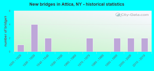
- New bridges - historical statistics
- 11920-1929
- 41930-1939
- 21940-1949
- 21970-1979
- 21990-1999
- 22000-2009
- 22010-2019

- Reconstructed bridges - Historical Statistics
- 11980-1989
- 01990-1999
- 12000-2009


- Bridge Condition - Deck
- 10.0%Excellent
- 10.0%Very good
- 50.0%Good
- 20.0%Satisfactory
- 10.0%Poor

- Bridge Condition - Superstructure
- 10.0%Excellent
- 30.0%Very good
- 30.0%Good
- 10.0%Satisfactory
- 10.0%Fair
- 10.0%Poor

- Bridge Condition - Substructure
- 10.0%Excellent
- 20.0%Very good
- 30.0%Good
- 20.0%Satisfactory
- 10.0%Fair
- 10.0%Poor

- Bridge Condition - Channel
- 7.7%Very good
- 7.7%Good
- 61.5%Satisfactory
- 23.1%Fair

- Bridge Condition - Culverts
- 33.3%Excellent
- 66.7%Satisfactory
Find on map >> Show street view
Structure Number: 103567, Location: 2.5MI S JCT RTS 98 & 354 (Lat: 42.828878, Lng: -78.294256), Route carried "on" structure: State highway 98, Year Built: 1993, Status: Open, Structure Length: 4.05m (13.29ft), Average Daily Traffic: 1,587 (year 2017), Truck Traffic: 9%, Average Future Daily Traffic: 1,655 (year 2040), Design Load: HS 25 or greater, Features Intersected: TONAWANDA CREEK
Minimum Vertical Clearance: 30+ m (98+ ft), Kilometerpoint: 42.236, Lanes on structure: 2, Base Highway Network: Yes, Owner: State Highway Agency, Approaching Roadway Width: 10.4m (34.1ft), Skew: 3 degrees, Material/Design: Steel, Design/Construction: Stringer/Multi-beam, Number Of Spans In Main Unit: 1, Length of Maximum Span: 39.3m (128.9ft), Curb-To-Curb Width: 10.4m (34.1ft), Out-to-Out Width: 11.0m (36.1ft)
Condition: Deck: Good, Superstructure: Very good, Substructure: Good, Channel: Fair, Inventory Rating: 76.2 metric tons, Method Used To Determine Inventory Rating: Load Factor (LF), Structural Evaluation: Better than present minimum criteria, Deck Geometry: Equal to present minimum criteria, Waterway Adequacy: Superior to present desirable criteria, Approach Roadway Alignment: Equal to present desirable criteria, Length Of Structure Improvement: 4.05m (13.29ft), Designated Inspection Frequency: Every 24 months, Inspection Date: November 2021, Bridge Improvement Cost: $1,319,000, Roadway Improvement Cost: $773,000, Total Project Cost: $2,092,000 ( Estimate for 2021), Deck Structure Type: Concrete Cast-file-Place, Wearing Surface/Protective System: Wearing Surface: Integral Concrete, Deck Protection: Epoxy Coated Reinforcing
Find on map >> Show street view
Structure Number: 103569, Location: 0.1 MI NE JCT RTS 98+238 (Lat: 42.869689, Lng: -78.284725), Route carried "on" structure: State highway 98, Year Built: 1948, Year Reconstructed: 1988, Status: Open, Structure Length: 1.34m (4.40ft), Average Daily Traffic: 4,933 (year 2020), Truck Traffic: 7%, Average Future Daily Traffic: 5,992 (year 2040), Design Load: HS 20, Features Intersected: TANNERY BROOK
Minimum Vertical Clearance: 30+ m (98+ ft), Kilometerpoint: 0.016, Lanes on structure: 2, Base Highway Network: Yes, Owner: State Highway Agency, Approaching Roadway Width: 12.8m (42.0ft), Skew: 1 degrees, Material/Design: Steel, Design/Construction: Stringer/Multi-beam, Number Of Spans In Main Unit: 1, Length of Maximum Span: 12.8m (42.0ft), Curb-To-Curb Width: 13.0m (42.7ft), Out-to-Out Width: 13.6m (44.6ft)
Condition: Deck: Very good, Superstructure: Good, Substructure: Good, Channel: Fair, Inventory Rating: 63.5 metric tons, Method Used To Determine Inventory Rating: Load Factor (LF), Structural Evaluation: Better than present minimum criteria, Deck Geometry: Equal to present minimum criteria, Waterway Adequacy: Equal to present desirable criteria, Approach Roadway Alignment: Equal to present desirable criteria, Length Of Structure Improvement: 1.34m (4.40ft), Designated Inspection Frequency: Every 24 months, Inspection Date: August 2021, Bridge Improvement Cost: $985,000, Roadway Improvement Cost: $577,000, Total Project Cost: $1,562,000 ( Estimate for 2021), Deck Structure Type: Concrete Cast-file-Place, Wearing Surface/Protective System: Wearing Surface: Integral Concrete, Deck Protection: Epoxy Coated Reinforcing
Find on map >> Show street view
Structure Number: 104244, Location: 3.1MI SE JCT RTS 238 + 98 (Lat: 42.838303, Lng: -78.254542), Route carried "on" structure: State highway 238, Year Built: 1932, Status: Open, Structure Length: 0.98m (3.22ft), Average Daily Traffic: 1,791 (year 2020), Truck Traffic: 9%, Average Future Daily Traffic: 1,802 (year 2040), Features Intersected: STEVENS BROOK
Minimum Vertical Clearance: 30+ m (98+ ft), Kilometerpoint: 12.357, Lanes on structure: 2, Base Highway Network: Yes, Owner: State Highway Agency, Approaching Roadway Width: 11.6m (38.1ft), Skew: 5 degrees, Material/Design: Concrete, Design/Construction: Culvert, Number Of Spans In Main Unit: 1, Length of Maximum Span: 8.2m (26.9ft)
Condition: Channel: Satisfactory, Culverts: Satisfactory, Operating Rating: 68.6 metric tons, Method Used To Determine Operating Rating: Field evaluation and documented engineering judgment, Inventory Rating: 26.9 metric tons, Method Used To Determine Inventory Rating: Field evaluation and documented engineering judgment, Structural Evaluation: Equal to present minimum criteria, Waterway Adequacy: Equal to present minimum criteria, Approach Roadway Alignment: Equal to present desirable criteria, Length Of Structure Improvement: 0.97m (3.18ft), Designated Inspection Frequency: Every 24 months, Inspection Date: April 2021, Bridge Improvement Cost: $449,000, Roadway Improvement Cost: $263,000, Total Project Cost: $711,000 ( Estimate for 2021)
Find on map >> Show street view
Structure Number: 104245, Location: 0.9MI E JCT RTS 238 + 98 (Lat: 42.863367, Lng: -78.267356), Route carried "on" structure: City street 238, Year Built: 2010, Status: Open, Structure Length: 0.91m (2.99ft), Average Daily Traffic: 3,927 (year 2017), Truck Traffic: 6%, Average Future Daily Traffic: 4,770 (year 2040), Design Load: HS 25 or greater, Features Intersected: STEVENS BROOK
Minimum Vertical Clearance: 30+ m (98+ ft), Kilometerpoint: 15.865, Lanes on structure: 2, Base Highway Network: Yes, Owner: State Highway Agency, Approaching Roadway Width: 8.5m (27.9ft), Material/Design: Concrete, Design/Construction: Frame, Number Of Spans In Main Unit: 1, Length of Maximum Span: 8.5m (27.9ft), Curb or Sidewalk Widths: Left: 0.0m, Right: 1.8m (5.9ft), Curb-To-Curb Width: 12.2m (40.0ft), Out-to-Out Width: 15.0m (49.2ft)
Condition: Deck: Good, Superstructure: Good, Substructure: Very good, Channel: Satisfactory, Operating Rating: 78.7 metric tons, Method Used To Determine Operating Rating: Field evaluation and documented engineering judgment, Inventory Rating: 40.8 metric tons, Method Used To Determine Inventory Rating: Field evaluation and documented engineering judgment, Structural Evaluation: Better than present minimum criteria, Deck Geometry: Equal to present minimum criteria, Waterway Adequacy: Superior to present desirable criteria, Approach Roadway Alignment: Equal to present desirable criteria, Length Of Structure Improvement: 0.91m (2.99ft), Designated Inspection Frequency: Every 24 months, Inspection Date: September 2021, Bridge Improvement Cost: $541,000, Roadway Improvement Cost: $317,000, Total Project Cost: $858,000 ( Estimate for 2021)
Find on map >> Show street view
Structure Number: 104246, Location: 0.1MI E JCT RTS 238 + 98 (Lat: 42.864206, Lng: -78.283533), Route carried "on" structure: State highway 238, Year Built: 1948, Status: Open, Structure Length: 2.71m (8.89ft), Average Daily Traffic: 3,927 (year 2017), Truck Traffic: 6%, Average Future Daily Traffic: 4,770 (year 2040), Features Intersected: TONAWANDA CREEK
Minimum Vertical Clearance: 30+ m (98+ ft), Kilometerpoint: 17.200, Lanes on structure: 2, Base Highway Network: Yes, Owner: State Highway Agency, Approaching Roadway Width: 13.4m (44.0ft), Material/Design: Concrete, Design/Construction: Frame, Number Of Spans In Main Unit: 1, Length of Maximum Span: 23.7m (77.8ft), Curb or Sidewalk Widths: Left: 2.1m (6.9ft), Right: 2.1m (6.9ft), Curb-To-Curb Width: 13.4m (44.0ft), Out-to-Out Width: 18.3m (60.0ft)
Condition: Deck: Satisfactory, Superstructure: Fair, Substructure: Satisfactory, Channel: Good, Operating Rating: 62.2 metric tons, Method Used To Determine Operating Rating: Field evaluation and documented engineering judgment, Inventory Rating: 21.8 metric tons, Method Used To Determine Inventory Rating: Field evaluation and documented engineering judgment, Structural Evaluation: Somewhat better than minimum adequacy, Deck Geometry: Better than present minimum criteria, Waterway Adequacy: Equal to present minimum criteria, Approach Roadway Alignment: Equal to present desirable criteria, Length Of Structure Improvement: 2.71m (8.89ft), Designated Inspection Frequency: Every 24 months, Inspection Date: November 2020, Bridge Improvement Cost: $1,676,000, Roadway Improvement Cost: $982,000, Total Project Cost: $2,658,000 ( Estimate for 2021)
Find on map >> Show street view
Structure Number: 107498, Location: .7 MI NW JCT SH98 & SH238 (Lat: 42.872933, Lng: -78.294006), Route carried "on" structure: State highway 238, Year Built: 2002, Status: Open, Structure Length: 0.82m (2.69ft), Average Daily Traffic: 2,769 (year 2017), Truck Traffic: 6%, Average Future Daily Traffic: 3,426 (year 2040), Design Load: HS 25 or greater, Features Intersected: TANNERY BROOK
Minimum Vertical Clearance: 30+ m (98+ ft), Kilometerpoint: 0.547, Lanes on structure: 2, Base Highway Network: Yes, Owner: State Highway Agency, Approaching Roadway Width: 11.0m (36.1ft), Skew: 1 degrees, Material/Design: Concrete, Design/Construction: Culvert, Number Of Spans In Main Unit: 1, Length of Maximum Span: 7.6m (24.9ft)
Condition: Channel: Satisfactory, Culverts: Excellent, Operating Rating: 80.7 metric tons, Method Used To Determine Operating Rating: Load Factor (LF), Inventory Rating: 49.0 metric tons, Method Used To Determine Inventory Rating: Load Factor (LF), Structural Evaluation: Superior to present desirable criteria, Waterway Adequacy: Meets minimum limits, Approach Roadway Alignment: Equal to present desirable criteria, Length Of Structure Improvement: 0.82m (2.69ft), Designated Inspection Frequency: Every 24 months, Inspection Date: November 2020, Bridge Improvement Cost: $313,000, Roadway Improvement Cost: $183,000, Total Project Cost: $497,000 ( Estimate for 2021)
Find on map >> Show street view
Structure Number: 33156, Location: 2.9 MI SW ALEXANDER (Lat: 42.871761, Lng: -78.295975), Route carried "on" structure: County highway , Year Built: 1978, Status: Open, Structure Length: 1.07m (3.51ft), Average Daily Traffic: 702 (year 2020), Truck Traffic: 4%, Average Future Daily Traffic: 868 (year 2040), Design Load: H 15, Features Intersected: TUNNERY CREEK, Facility Carried by Structure: ATTICA ROAD
Minimum Vertical Clearance: 30+ m (98+ ft), Kilometerpoint: 3.009, Lanes on structure: 2, Owner: County Highway Agency, Approaching Roadway Width: 6.7m (22.0ft), Material/Design: Wood or Timber, Design/Construction: Slab, Number Of Spans In Main Unit: 1, Length of Maximum Span: 9.4m (30.8ft), Curb-To-Curb Width: 9.3m (30.5ft), Out-to-Out Width: 9.8m (32.2ft)
Condition: Deck: Satisfactory, Superstructure: Satisfactory, Substructure: Fair, Channel: Satisfactory, Operating Rating: 46.4 metric tons, Method Used To Determine Operating Rating: Field evaluation and documented engineering judgment, Inventory Rating: 19.0 metric tons, Method Used To Determine Inventory Rating: Field evaluation and documented engineering judgment, Structural Evaluation: Somewhat better than minimum adequacy, Deck Geometry: Equal to present minimum criteria, Waterway Adequacy: Equal to present minimum criteria, Approach Roadway Alignment: Equal to present desirable criteria, Length Of Structure Improvement: 1.06m (3.48ft), Designated Inspection Frequency: Every 24 months, Inspection Date: April 2021, Bridge Improvement Cost: $417,000, Roadway Improvement Cost: $244,000, Total Project Cost: $661,000 ( Estimate for 2021), Wearing Surface/Protective System: Wearing Surface: Bituminous, Membrane: Other
Find on map >> Show street view
Structure Number: 331561, Location: 3.3 MI SW ALEXANDER (Lat: 42.872967, Lng: -78.307253), Route carried "on" structure: County highway , Year Built: 1939, Status: Posted for load, Structure Length: 0.73m (2.40ft), Average Daily Traffic: 285 (year 2017), Truck Traffic: 4%, Average Future Daily Traffic: 399 (year 2037), Design Load: H 15, Features Intersected: TUNNERY CREEK, Facility Carried by Structure: DARIEN-ALEXANDER
Minimum Vertical Clearance: 30+ m (98+ ft), Kilometerpoint: 0.338, Lanes on structure: 2, Owner: County Highway Agency, Approaching Roadway Width: 6.1m (20.0ft), Material/Design: Steel, Design/Construction: Stringer/Multi-beam, Number Of Spans In Main Unit: 1, Length of Maximum Span: 7.0m (23.0ft), Curb-To-Curb Width: 7.2m (23.6ft), Out-to-Out Width: 7.6m (24.9ft)
Condition: Deck: Poor, Superstructure: Poor, Substructure: Poor, Channel: Fair, Operating Rating: 10.9 metric tons, Method Used To Determine Operating Rating: Field evaluation and documented engineering judgment, Inventory Rating: 10.9 metric tons, Method Used To Determine Inventory Rating: Field evaluation and documented engineering judgment, Structural Evaluation: Meets minimum limits, Deck Geometry: Meets minimum limits, Waterway Adequacy: Better than present minimum criteria, Approach Roadway Alignment: Equal to present desirable criteria, Bridge Posting: Required (Relationship of Operating Rating to Maximum Legal Load: > 39.9% below), Length Of Structure Improvement: 0.73m (2.40ft), Designated Inspection Frequency: Every 12 months, Inspection Date: April 2021, Bridge Improvement Cost: $311,000, Roadway Improvement Cost: $182,000, Total Project Cost: $493,000 ( Estimate for 2021), Deck Structure Type: Concrete Cast-file-Place, Wearing Surface/Protective System: Wearing Surface: Bituminous
Find on map >> Show street view
Structure Number: 331582, Location: 1.7 MI SOUTH OF ALEXANDER (Lat: 42.877197, Lng: -78.257581), Route carried "on" structure: County highway , Year Built: 2018, Status: Open, Structure Length: 3.29m (10.79ft), Average Daily Traffic: 1,482 (year 2017), Truck Traffic: 7%, Average Future Daily Traffic: 2,075 (year 2037), Design Load: HS 25 or greater, Features Intersected: TONAWANDA CREEK, Facility Carried by Structure: COUNTY ROAD 1
Minimum Vertical Clearance: 30+ m (98+ ft), Kilometerpoint: 0.547, Lanes on structure: 2, Owner: County Highway Agency, Approaching Roadway Width: 9.1m (29.9ft), Skew: 1 degrees, Material/Design: Prestressed concrete, Design/Construction: Box Beam or Girders - Multiple, Number Of Spans In Main Unit: 1, Length of Maximum Span: 32.0m (105.0ft), Curb-To-Curb Width: 9.2m (30.2ft), Out-to-Out Width: 10.1m (33.1ft)
Condition: Deck: Excellent, Superstructure: Excellent, Substructure: Excellent, Channel: Very good, Inventory Rating: 51.7 metric tons, Method Used To Determine Inventory Rating: Load Factor (LF), Structural Evaluation: Superior to present desirable criteria, Deck Geometry: Somewhat better than minimum adequacy, Waterway Adequacy: Better than present minimum criteria, Approach Roadway Alignment: Somewhat better than minimum adequacy, Length Of Structure Improvement: 3.29m (10.79ft), Designated Inspection Frequency: Every 24 months, Inspection Date: November 2020, Bridge Improvement Cost: $724,000, Roadway Improvement Cost: $424,000, Total Project Cost: $1,148,000 ( Estimate for 2021), Wearing Surface/Protective System: Wearing Surface: Integral Concrete
Find on map >> Show street view
Structure Number: 331954, Location: 1 MI S VILLAGE OF ATTICA (Lat: 42.845664, Lng: -78.280633), Route carried "on" structure: Other road , Year Built: 2000, Status: Open, Structure Length: 3.32m (10.89ft), Average Daily Traffic: 1,465 (year 2020), Truck Traffic: 4%, Average Future Daily Traffic: 2,051 (year 2040), Design Load: HS 25 or greater, Features Intersected: TONAWANDA CREEK, Facility Carried by Structure: DUNBAR ROAD
Minimum Vertical Clearance: 30+ m (98+ ft), Kilometerpoint: 0.241, Lanes on structure: 2, Owner: County Highway Agency, Approaching Roadway Width: 8.2m (26.9ft), Skew: 1 degrees, Material/Design: Prestressed concrete, Design/Construction: Box Beam or Girders - Multiple, Number Of Spans In Main Unit: 1, Length of Maximum Span: 31.6m (103.7ft), Curb-To-Curb Width: 7.9m (25.9ft), Out-to-Out Width: 9.0m (29.5ft)
Condition: Deck: Good, Superstructure: Good, Substructure: Good, Channel: Satisfactory, Operating Rating: 95.9 metric tons, Method Used To Determine Operating Rating: Load and Resistance Factor Rating (LRFR) rating reported by rating factor(RF) method using HL-93 loadings, Inventory Rating: 72.3 metric tons, Method Used To Determine Inventory Rating: Load and Resistance Factor Rating (LRFR) rating reported by rating factor(RF) method using HL-93 loadings, Structural Evaluation: Better than present minimum criteria, Deck Geometry: Meets minimum limits, Waterway Adequacy: Somewhat better than minimum adequacy, Approach Roadway Alignment: Equal to present desirable criteria, Length Of Structure Improvement: 3.32m (10.89ft), Designated Inspection Frequency: Every 24 months, Inspection Date: July 2020, Bridge Improvement Cost: $837,000, Roadway Improvement Cost: $490,000, Total Project Cost: $1,327,000 ( Estimate for 2021), Deck Structure Type: Concrete Cast-file-Place, Wearing Surface/Protective System: Wearing Surface: Integral Concrete, Deck Protection: Epoxy Coated Reinforcing
Find on map >> Show street view
Structure Number: 331955, Location: 3.2 MILES SW OF ATTICA (Lat: 42.821931, Lng: -78.302531), Route carried "on" structure: Other road , Year Built: 1937, Year Reconstructed: 2007, Status: Open, Structure Length: 2.19m (7.19ft), Average Daily Traffic: 3 (year 2016), Truck Traffic: 5%, Average Future Daily Traffic: 4 (year 2036), Features Intersected: TONAWANDA CREEK, Facility Carried by Structure: COTTON HILL ROAD
Minimum Vertical Clearance: 30+ m (98+ ft), Kilometerpoint: 0.000, Lanes on structure: 1, Owner: County Highway Agency, Approaching Roadway Width: 3.7m (12.1ft), Material/Design: Steel, Design/Construction: Truss - Thru, Number Of Spans In Main Unit: 1, Length of Maximum Span: 21.3m (69.9ft), Curb-To-Curb Width: 4.0m (13.1ft), Out-to-Out Width: 4.4m (14.4ft)
Condition: Deck: Good, Superstructure: Very good, Substructure: Satisfactory, Channel: Satisfactory, Operating Rating: 60.1 metric tons, Method Used To Determine Operating Rating: Field evaluation and documented engineering judgment, Inventory Rating: 23.4 metric tons, Method Used To Determine Inventory Rating: Field evaluation and documented engineering judgment, Structural Evaluation: Equal to present minimum criteria, Deck Geometry: Somewhat better than minimum adequacy, Waterway Adequacy: Somewhat better than minimum adequacy, Approach Roadway Alignment: High priority of corrective action, Length Of Structure Improvement: 2.19m (7.19ft), Designated Inspection Frequency: Every 24 months, Critical Feature Inspection Frequency: Every 24 months, Inspection Date: August 2021, Critical Feature Inspection Date: August 2021, Bridge Improvement Cost: $741,000, Roadway Improvement Cost: $434,000, Total Project Cost: $1,175,000 ( Estimate for 2021), Deck Structure Type: Open Grating, Wearing Surface/Protective System: Wearing Surface: Other
Find on map >> Show street view
Structure Number: 331956, Location: N BORDER VILLAGE ATTICA (Lat: 42.869417, Lng: -78.277464), Route carried "on" structure: Other road , Year Built: 1998, Status: Open, Structure Length: 3.32m (10.89ft), Average Daily Traffic: 2,903 (year 2020), Truck Traffic: 4%, Average Future Daily Traffic: 4,064 (year 2040), Design Load: HS 25 or greater, Features Intersected: TONAWANDA CREEK, Facility Carried by Structure: PROSPECT STREET
Minimum Vertical Clearance: 30+ m (98+ ft), Kilometerpoint: 0.274, Lanes on structure: 2, Owner: County Highway Agency, Approaching Roadway Width: 8.8m (28.9ft), Skew: 1 degrees, Material/Design: Prestressed concrete, Design/Construction: Box Beam or Girders - Multiple, Number Of Spans In Main Unit: 1, Length of Maximum Span: 32.3m (106.0ft), Curb or Sidewalk Widths: Left: 1.5m (4.9ft), Right: 1.5m (4.9ft), Curb-To-Curb Width: 8.9m (29.2ft), Out-to-Out Width: 12.7m (41.7ft)
Condition: Deck: Good, Superstructure: Very good, Substructure: Very good, Channel: Satisfactory, Operating Rating: 89.8 metric tons, Method Used To Determine Operating Rating: Load Factor (LF), Inventory Rating: 69.9 metric tons, Method Used To Determine Inventory Rating: Load Factor (LF), Structural Evaluation: Equal to present desirable criteria, Deck Geometry: Meets minimum limits, Waterway Adequacy: Equal to present desirable criteria, Approach Roadway Alignment: Equal to present desirable criteria, Length Of Structure Improvement: 3.32m (10.89ft), Designated Inspection Frequency: Every 24 months, Inspection Date: March 2021, Bridge Improvement Cost: $1,143,000, Roadway Improvement Cost: $669,000, Total Project Cost: $1,812,000 ( Estimate for 2021), Deck Structure Type: Concrete Cast-file-Place, Wearing Surface/Protective System: Wearing Surface: Integral Concrete
Find on map >> Show street view
Structure Number: 336637, Location: 1.1 MI SOUTH OF ALEXANDER (Lat: 42.877997, Lng: -78.259256), Route carried "on" structure: County highway , Year Built: 1976, Status: Open, Structure Length: 0.85m (2.79ft), Average Daily Traffic: 1,023 (year 2016), Truck Traffic: 13%, Average Future Daily Traffic: 1,432 (year 2036), Features Intersected: TRIB TONAWANDA CK, Facility Carried by Structure: Stroh Road
Minimum Vertical Clearance: 30+ m (98+ ft), Kilometerpoint: 1.400, Lanes on structure: 2, Owner: County Highway Agency, Approaching Roadway Width: 7.9m (25.9ft), Material/Design: Steel, Design/Construction: Culvert, Number Of Spans In Main Unit: 2, Length of Maximum Span: 3.9m (12.8ft)
Condition: Channel: Satisfactory, Culverts: Satisfactory, Operating Rating: 75.1 metric tons, Method Used To Determine Operating Rating: Field evaluation and documented engineering judgment, Inventory Rating: 29.4 metric tons, Method Used To Determine Inventory Rating: Field evaluation and documented engineering judgment, Structural Evaluation: Equal to present minimum criteria, Waterway Adequacy: Equal to present desirable criteria, Approach Roadway Alignment: Equal to present desirable criteria, Length Of Structure Improvement: 0.85m (2.79ft), Designated Inspection Frequency: Every 24 months, Inspection Date: April 2021, Bridge Improvement Cost: $121,000, Roadway Improvement Cost: $71,000, Total Project Cost: $192,000 ( Estimate for 2021)
Find on map >> Show street view
Structure Number: 703568, Location: 0.05MI S JCT RTS 98 + 354 (Lat: 42.864036, Lng: -78.284358), Route carried "under" structure: Alternate State highway 98, Year Built: 1930, Structure Length: 0. m, Average Daily Traffic: 7,263 (year 1999), Features Intersected: RTE 98, Facility Carried by Structure: NORFOLK SOUTHERN
Minimum Vertical Clearance: 4.31m (14.14ft), Kilometerpoint: 46.291, Lanes under structure: 2, Material/Design: Steel, Design/Construction: Girder and Floorbeam System, Length of Maximum Span: 11.5m (37.7ft)
Find on map >> Show street view
Structure Number: 770725, Location: .5 MI NW VILLAGE O/ATTICA (Lat: 42.871950, Lng: -78.297111), Route carried "under" structure: ServiceCounty highway , Year Built: 1921, Structure Length: 0. m, Average Daily Traffic: 702 (year 2020), Truck Traffic: 4%, Features Intersected: ATTICA ROAD CR 45, Facility Carried by Structure: NORFOLK SOUTHERN
Minimum Vertical Clearance: 4.24m (13.91ft), Kilometerpoint: 2.011, Lanes under structure: 2, Material/Design: Steel, Design/Construction: Girder and Floorbeam System, Length of Maximum Span: 11.5m (37.7ft)