Bridge Statistics for Auburn, Maine (ME)
Condition, Traffic, Stress, Structural Evaluation, Project Costs
- National Bridge Inventory (NBI) Statistics
- 38Number of bridges
- 443ft / 135mTotal length
- 1,892,493Total average daily traffic
- 125,607Total average daily truck traffic
- National Bridge Inventory (NBI) Registered Bridges for Auburn
- No street view available for this location
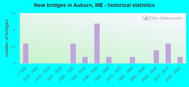
- New bridges - historical statistics
- 3Before 1900
- 31930-1939
- 11940-1949
- 61950-1959
- 11960-1969
- 11980-1989
- 22000-2009
- 32010-2019
- 12020-2022

- Reconstructed bridges - Historical Statistics
- 11950-1959
- 11960-1969
- 11970-1979
- 11980-1989
- 21990-1999
- 22000-2009
- 12010-2019


- Bridge Condition - Deck
- 4.5%Excellent
- 13.6%Very good
- 31.8%Good
- 22.7%Satisfactory
- 22.7%Fair
- 4.5%Poor

- Bridge Condition - Superstructure
- 4.5%Excellent
- 22.7%Very good
- 13.6%Good
- 18.2%Satisfactory
- 36.4%Fair
- 4.5%Poor

- Bridge Condition - Substructure
- 4.5%Excellent
- 18.2%Very good
- 18.2%Good
- 36.4%Satisfactory
- 13.6%Fair
- 9.1%Poor

- Bridge Condition - Channel
- 7.1%Excellent
- 14.3%Very good
- 21.4%Good
- 28.6%Satisfactory
- 21.4%Fair
- 7.1%Poor
Find on map >> Show street view
Location: .1 MI W TOWNLINE (Lat: 36.001222, Lng: -531.101947), Route carried "under" structure: 71310, Year Built: 1011, Status: Open, Structure Length: 0.84m (2.76ft), Average Daily Traffic: 502,000 (year 1924), Truck Traffic: 9%, Average Future Daily Traffic: 26,939 (year 2036), Design Load: H 15, Features Intersected: 02060PEDESTRIAN WALKWAY, Facility Carried by Structure: MAIN ST
Lanes on structure: 41, Lanes under structure: 97, Base Highway Network: Yes (Inventory Route: 791000, Subroute: 1), Toll: , Owner: County Highway Agency, Approaching Roadway Width: 201.60m (661.42ft), Skew: 22 degrees, Material/Design: Prestressed concrete, Design/Construction: Slab, Number Of Spans In Main Unit: 1, Length of Maximum Span: 6.0m (19.7ft), Curb or Sidewalk Widths: Left: 2.6m (8.5ft), Right: 3.0m (9.8ft), Curb-To-Curb Width: 14.8m (48.6ft), Out-to-Out Width: 22.4m (73.5ft)
Condition: Deck: Poor, Superstructure: Poor, Substructure: Fair, Operating Rating: 42.1 metric tons, Method Used To Determine Operating Rating: Load and Resistance Factor Rating (LRFR) rating reported by rating factor(RF) method using HL-93 loadings, Inventory Rating: 32.4 metric tons, Method Used To Determine Inventory Rating: Load and Resistance Factor Rating (LRFR) rating reported by rating factor(RF) method using HL-93 loadings, Structural Evaluation: Meets minimum limits, Deck Geometry: Superior to present desirable criteria, Approach Roadway Alignment: Equal to present desirable criteria, Designated Inspection Frequency: Every 12 months, Inspection Date: November 2021, Deck Structure Type: Concrete Precast Panels, Wearing Surface/Protective System: Wearing Surface: Bituminous
Find on map >> Show street view
Location: 300 FT E RT 4 (Lat: 12.334556, Lng: -841.001947), Route carried "under" structure: Ramp 1500, Year Built: 1011, Year Reconstructed: 2014, Status: Open, Structure Length: 0.73m (2.40ft), Average Daily Traffic: 502,000 (year 0063), Truck Traffic: 5%, Average Future Daily Traffic: 1,022 (year 2036), Design Load: HS 25 or greater, Features Intersected: 02060BOBBIN MILL BROOK, Facility Carried by Structure: FAIR ST
Lanes on structure: 91, Lanes under structure: 92, Toll: , Approaching Roadway Width: 201.60m (661.42ft), Material/Design: Steel, Design/Construction: Stringer/Multi-beam, Number Of Spans In Main Unit: 1, Length of Maximum Span: 6.7m (22.0ft), Curb or Sidewalk Widths: Left: 1.6m (5.2ft), Right: 0.0m, Curb-To-Curb Width: 6.3m (20.7ft), Out-to-Out Width: 8.2m (26.9ft)
Condition: Deck: Satisfactory, Superstructure: Fair, Substructure: Satisfactory, Channel: Fair, Operating Rating: 37.6 metric tons, Method Used To Determine Operating Rating: Load and Resistance Factor Rating (LRFR) rating reported by rating factor(RF) method using HL-93 loadings, Inventory Rating: 29.2 metric tons, Method Used To Determine Inventory Rating: Load and Resistance Factor Rating (LRFR) rating reported by rating factor(RF) method using HL-93 loadings, Structural Evaluation: Somewhat better than minimum adequacy, Deck Geometry: High priority of corrective action, Waterway Adequacy: Equal to present desirable criteria, Approach Roadway Alignment: Somewhat better than minimum adequacy, Designated Inspection Frequency: Every 24 months, Inspection Date: April 2021, Deck Structure Type: Concrete Cast-file-Place, Wearing Surface/Protective System: Wearing Surface: Bituminous
Find on map >> Show street view
Location: ER RD100FT SE RT 202 (Lat: 9.001222, Lng: -234.568614), Route carried "under" structure: Ramp 61500, Year Built: 3031, Year Reconstructed: 1983, Status: Open, Structure Length: 1.28m (4.20ft), Average Daily Traffic: 2,000 (year 0182), Truck Traffic: 5%, Average Future Daily Traffic: 2,742 (year 2036), Design Load: Railroad, Features Intersected: 02060MCRR, Facility Carried by Structure: DANVILLE CORN
Lanes on structure: 91, Lanes under structure: 93, Toll: , Owner: Town or Township Highway Agency, Approaching Roadway Width: 201.60m (661.42ft), Skew: 1 degrees, Material/Design: Prestressed concrete, Design/Construction: Slab, Number Of Spans In Main Unit: 1, Length of Maximum Span: 11.2m (36.7ft), Curb or Sidewalk Widths: Left: 0.2m (0.7ft), Right: 0.2m (0.7ft), Curb-To-Curb Width: 7.9m (25.9ft), Out-to-Out Width: 9.3m (30.5ft)
Condition: Deck: Fair, Superstructure: Fair, Substructure: Poor, Operating Rating: 44.1 metric tons, Method Used To Determine Operating Rating: Load and Resistance Factor Rating (LRFR) rating reported by rating factor(RF) method using HL-93 loadings, Inventory Rating: 34.0 metric tons, Method Used To Determine Inventory Rating: Load and Resistance Factor Rating (LRFR) rating reported by rating factor(RF) method using HL-93 loadings, Structural Evaluation: Meets minimum limits, Deck Geometry: Meets minimum limits, Underclear: Somewhat better than minimum adequacy, Approach Roadway Alignment: Somewhat better than minimum adequacy, Designated Inspection Frequency: Every 24 months, Inspection Date: December 2021, Deck Structure Type: Concrete Precast Panels, Wearing Surface/Protective System: Wearing Surface: Low Slump Concrete
Find on map >> Show street view
Location: ER RD0.176 mi E of US 202 (Lat: 9.001222, Lng: -226.868614), Route carried "under" structure: Service 31500, Year Built: 1311, Status: Open, Structure Length: 6.31m (20.70ft), Average Daily Traffic: 602,040 (year 0182), Truck Traffic: 5%, Average Future Daily Traffic: 2,742 (year 2036), Design Load: Railroad, Features Intersected: 02060I-95, Facility Carried by Structure: DANVILLE CORN
Lanes on structure: 91, Lanes under structure: 99, Approaching Roadway Width: 201.60m (661.42ft), Skew: A1 degrees, Material/Design: Steel continuous, Design/Construction: Stringer/Multi-beam, Number Of Spans In Main Unit: 4, Length of Maximum Span: 18.0m (59.1ft), Curb-To-Curb Width: 7.0m (23.0ft), Out-to-Out Width: 7.9m (25.9ft)
Condition: Deck: Good, Superstructure: Good, Substructure: Very good, Operating Rating: 40.8 metric tons, Method Used To Determine Operating Rating: Load and Resistance Factor Rating (LRFR) rating reported by rating factor(RF) method using HL-93 loadings, Inventory Rating: 31.4 metric tons, Method Used To Determine Inventory Rating: Load and Resistance Factor Rating (LRFR) rating reported by rating factor(RF) method using HL-93 loadings, Structural Evaluation: Better than present minimum criteria, Deck Geometry: High priority of corrective action, Underclear: Meets minimum limits, Approach Roadway Alignment: Equal to present minimum criteria, Designated Inspection Frequency: Every 24 months, Inspection Date: May 2021, Deck Structure Type: Concrete Cast-file-Place, Wearing Surface/Protective System: Wearing Surface: Bituminous, Membrane: Preformed Fabric, Deck Protection: Epoxy Coated Reinforcing
Find on map >> Show street view
Structure Number: 1492, Location: 0.130 mi E of Hotel Rd (Lat: 44.032511, Lng: -70.282750), Route carried "on" structure: Interstate 95, Year Built: 1956, Status: Open, Structure Length: 3.41m (11.19ft), Average Daily Traffic: 9,830 (year 2016), Truck Traffic: 11%, Average Future Daily Traffic: 13,762 (year 2036), Design Load: HL 93, Features Intersected: ST. LAWRENCE-ATLANTIC RR
Minimum Vertical Clearance: 30+ m (98+ ft), Kilometerpoint: 369.427, Lanes on structure: 2, Base Highway Network: Yes, Toll: On Interstate toll segment, Owner: State Toll Authority, Approaching Roadway Width: 9.8m (32.2ft), Skew: 9 degrees, Material/Design: Steel continuous, Design/Construction: Stringer/Multi-beam, Number Of Spans In Main Unit: 3, Length of Maximum Span: 13.4m (44.0ft), Curb or Sidewalk Widths: Left: 0.2m (0.7ft), Right: 0.2m (0.7ft), Curb-To-Curb Width: 9.8m (32.2ft), Out-to-Out Width: 10.9m (35.8ft)
Condition: Deck: Good, Superstructure: Satisfactory, Substructure: Good, Operating Rating: 49.6 metric tons, Method Used To Determine Operating Rating: Load and Resistance Factor Rating (LRFR) rating reported by rating factor(RF) method using HL-93 loadings, Inventory Rating: 38.2 metric tons, Method Used To Determine Inventory Rating: Load and Resistance Factor Rating (LRFR) rating reported by rating factor(RF) method using HL-93 loadings, Structural Evaluation: Equal to present minimum criteria, Deck Geometry: High priority of replacement, Underclear: Equal to present minimum criteria, Approach Roadway Alignment: Better than present minimum criteria, Designated Inspection Frequency: Every 24 months, Inspection Date: May 2021, Deck Structure Type: Concrete Cast-file-Place, Wearing Surface/Protective System: Wearing Surface: Bituminous, Membrane: Preformed Fabric
Find on map >> Show street view
Structure Number: 1493, Location: 0.095 mi N of Allied Rd (Lat: 44.039481, Lng: -70.262761), Route carried "on" structure: Interstate 95, Year Built: 2012, Status: Open, Structure Length: 19.51m (64.01ft), Average Daily Traffic: 9,180 (year 2016), Truck Traffic: 11%, Average Future Daily Traffic: 12,852 (year 2036), Design Load: HL 93, Features Intersected: WASHINGTON ST & MCRR
Minimum Vertical Clearance: 30+ m (98+ ft), Kilometerpoint: 367.849, Lanes on structure: 2, Lanes under structure: 4, Base Highway Network: Yes, Toll: On Interstate toll segment, Owner: State Toll Authority, Approaching Roadway Width: 11.6m (38.1ft), Skew: 3 degrees, Material/Design: Steel continuous, Design/Construction: Stringer/Multi-beam, Number Of Spans In Main Unit: 8, Length of Maximum Span: 25.9m (85.0ft), Curb-To-Curb Width: 11.6m (38.1ft), Out-to-Out Width: 12.5m (41.0ft)
Condition: Deck: Good, Superstructure: Good, Substructure: Satisfactory, Operating Rating: 49.9 metric tons, Method Used To Determine Operating Rating: Load and Resistance Factor Rating (LRFR) rating reported by rating factor(RF) method using HL-93 loadings, Inventory Rating: 38.6 metric tons, Method Used To Determine Inventory Rating: Load and Resistance Factor Rating (LRFR) rating reported by rating factor(RF) method using HL-93 loadings, Structural Evaluation: Equal to present minimum criteria, Deck Geometry: Equal to present minimum criteria, Underclear: Meets minimum limits, Approach Roadway Alignment: Better than present minimum criteria, Designated Inspection Frequency: Every 24 months, Inspection Date: May 2021, Deck Structure Type: Concrete Cast-file-Place, Wearing Surface/Protective System: Wearing Surface: Bituminous, Membrane: Epoxy, Deck Protection: Epoxy Coated Reinforcing
Find on map >> Show street view
Structure Number: 1494, Location: 0.151 mi E of Vickery Rd (Lat: 44.064531, Lng: -70.207250), Route carried "on" structure: Interstate 95, Year Built: 1956, Year Reconstructed: 2014, Status: Open, Structure Length: 25.78m (84.58ft), Average Daily Traffic: 9,180 (year 2016), Truck Traffic: 11%, Average Future Daily Traffic: 12,852 (year 2036), Design Load: HL 93, Features Intersected: ANDROSCOGGIN RIVER
Minimum Vertical Clearance: 30+ m (98+ ft), Kilometerpoint: 362.152, Lanes on structure: 2, Lanes under structure: 2, Base Highway Network: Yes, Toll: On Interstate toll segment, Owner: State Toll Authority, Approaching Roadway Width: 11.6m (38.1ft), Skew: 3 degrees, Material/Design: Steel continuous, Design/Construction: Girder and Floorbeam System, Number Of Spans In Main Unit: 6, Length of Maximum Span: 46.0m (150.9ft), Curb-To-Curb Width: 11.6m (38.1ft), Out-to-Out Width: 12.5m (41.0ft)
Condition: Deck: Good, Superstructure: Fair, Substructure: Good, Channel: Good, Operating Rating: 42.1 metric tons, Method Used To Determine Operating Rating: Load and Resistance Factor Rating (LRFR) rating reported by rating factor(RF) method using HL-93 loadings, Inventory Rating: 32.4 metric tons, Method Used To Determine Inventory Rating: Load and Resistance Factor Rating (LRFR) rating reported by rating factor(RF) method using HL-93 loadings, Structural Evaluation: Somewhat better than minimum adequacy, Deck Geometry: Equal to present minimum criteria, Underclear: High priority of corrective action, Waterway Adequacy: Superior to present desirable criteria, Approach Roadway Alignment: Equal to present desirable criteria, Designated Inspection Frequency: Every 24 months, Critical Feature Inspection Frequency: Every 24 months, Underwater Inspection Frequency: Every 60 months, Inspection Date: May 2021, Critical Feature Inspection Date: May 2019, Underwater Inspection Date: July 2021, Deck Structure Type: Concrete Cast-file-Place, Wearing Surface/Protective System: Wearing Surface: Bituminous, Membrane: Preformed Fabric, Deck Protection: Epoxy Coated Reinforcing
Find on map >> Show street view
Structure Number: 2625, Location: 2.3 MI S 11,121 (Lat: 44.059681, Lng: -70.252881), Route carried "on" structure: State highway 202, Year Built: 2015, Status: Open, Structure Length: 6.50m (21.33ft), Average Daily Traffic: 8,930 (year 2016), Truck Traffic: 9%, Average Future Daily Traffic: 12,502 (year 2036), Design Load: Greater than HL93, Features Intersected: LITTLE ANDROSCOGGIN RIVE, Facility Carried by Structure: N WASHINGTON ST
Minimum Vertical Clearance: 30+ m (98+ ft), Kilometerpoint: 112.010, Lanes on structure: 2, Base Highway Network: Yes, Owner: State Highway Agency, Approaching Roadway Width: 12.2m (40.0ft), Skew: 3 degrees, Material/Design: Steel continuous, Design/Construction: Stringer/Multi-beam, Number Of Spans In Main Unit: 2, Length of Maximum Span: 31.1m (102.0ft), Curb or Sidewalk Widths: Left: 0.5m (1.6ft), Right: 0.5m (1.6ft), Curb-To-Curb Width: 10.4m (34.1ft), Out-to-Out Width: 11.4m (37.4ft)
Condition: Deck: Very good, Superstructure: Very good, Substructure: Very good, Channel: Very good, Operating Rating: 51.8 metric tons, Method Used To Determine Operating Rating: Load and Resistance Factor Rating (LRFR) rating reported by rating factor(RF) method using HL-93 loadings, Inventory Rating: 40.2 metric tons, Method Used To Determine Inventory Rating: Load and Resistance Factor Rating (LRFR) rating reported by rating factor(RF) method using HL-93 loadings, Structural Evaluation: Equal to present desirable criteria, Deck Geometry: Somewhat better than minimum adequacy, Waterway Adequacy: Better than present minimum criteria, Approach Roadway Alignment: Better than present minimum criteria, Designated Inspection Frequency: Every 24 months, Underwater Inspection Frequency: Every 60 months, Inspection Date: December 2020, Underwater Inspection Date: May 2019, Deck Structure Type: Concrete Cast-file-Place, Wearing Surface/Protective System: Wearing Surface: Bituminous, Membrane: Other, Deck Protection: Epoxy Coated Reinforcing
Find on map >> Show street view
Structure Number: 2648, Location: 0.9 MI W OF JCT RTE 4 (Lat: 44.082481, Lng: -70.249289), Route carried "on" structure: State highway 11, Year Built: 1930, Year Reconstructed: 1957, Status: Open, Structure Length: 0.64m (2.10ft), Average Daily Traffic: 10,480 (year 2016), Truck Traffic: 9%, Average Future Daily Traffic: 14,672 (year 2036), Design Load: H 20, Features Intersected: TAYLOR BROOK, Facility Carried by Structure: MINOT AV
Minimum Vertical Clearance: 30+ m (98+ ft), Kilometerpoint: 143.714, Lanes on structure: 4, Base Highway Network: Yes, Owner: State Highway Agency, Approaching Roadway Width: 15.9m (52.2ft), Material/Design: Concrete, Design/Construction: Slab, Number Of Spans In Main Unit: 1, Length of Maximum Span: 4.9m (16.1ft), Curb or Sidewalk Widths: Left: 3.6m (11.8ft), Right: 1.5m (4.9ft), Curb-To-Curb Width: 15.9m (52.2ft), Out-to-Out Width: 21.5m (70.5ft)
Condition: Deck: Fair, Superstructure: Fair, Substructure: Poor, Channel: Poor, Operating Rating: 23.0 metric tons, Method Used To Determine Operating Rating: Load and Resistance Factor Rating (LRFR) rating reported by rating factor(RF) method using HL-93 loadings, Inventory Rating: 17.8 metric tons, Method Used To Determine Inventory Rating: Load and Resistance Factor Rating (LRFR) rating reported by rating factor(RF) method using HL-93 loadings, Structural Evaluation: Meets minimum limits, Deck Geometry: Meets minimum limits, Waterway Adequacy: Equal to present desirable criteria, Approach Roadway Alignment: Equal to present desirable criteria, Designated Inspection Frequency: Every 24 months, Inspection Date: December 2020, Deck Structure Type: Concrete Cast-file-Place, Wearing Surface/Protective System: Wearing Surface: Bituminous
Find on map >> Show street view
Structure Number: 2875, Location: 3.3 MI N JCT US 202 (Lat: 44.146569, Lng: -70.228889), Route carried "on" structure: State highway 4, Year Built: 1953, Year Reconstructed: 1968, Status: Open, Structure Length: 0.73m (2.40ft), Average Daily Traffic: 20,052 (year 2016), Truck Traffic: 9%, Average Future Daily Traffic: 28,073 (year 2036), Design Load: H 20, Features Intersected: LAKE AUBURN OUTLET, Facility Carried by Structure: TURNER RD
Minimum Vertical Clearance: 30+ m (98+ ft), Kilometerpoint: 126.704, Lanes on structure: 4, Base Highway Network: Yes, Owner: State Highway Agency, Approaching Roadway Width: 20.7m (67.9ft), Material/Design: Concrete, Design/Construction: Slab, Number Of Spans In Main Unit: 2, Length of Maximum Span: 3.3m (10.8ft), Curb or Sidewalk Widths: Left: 0.2m (0.7ft), Right: 0.2m (0.7ft), Curb-To-Curb Width: 21.0m (68.9ft), Out-to-Out Width: 21.9m (71.9ft)
Condition: Deck: Fair, Superstructure: Fair, Substructure: Satisfactory, Channel: Satisfactory, Operating Rating: 32.1 metric tons, Method Used To Determine Operating Rating: Load and Resistance Factor Rating (LRFR) rating reported by rating factor(RF) method using HL-93 loadings, Inventory Rating: 24.6 metric tons, Method Used To Determine Inventory Rating: Load and Resistance Factor Rating (LRFR) rating reported by rating factor(RF) method using HL-93 loadings, Structural Evaluation: Somewhat better than minimum adequacy, Deck Geometry: Superior to present desirable criteria, Waterway Adequacy: Equal to present desirable criteria, Approach Roadway Alignment: Equal to present desirable criteria, Designated Inspection Frequency: Every 24 months, Underwater Inspection Frequency: Every 60 months, Inspection Date: August 2021, Underwater Inspection Date: July 2021, Deck Structure Type: Concrete Cast-file-Place, Wearing Surface/Protective System: Wearing Surface: Bituminous
Find on map >> Show street view
Structure Number: 3076, Location: LEWISTON-AUBURN TL (Lat: 44.097200, Lng: -70.223000), Route carried "on" structure: State highway 202, Year Built: 1983, Status: Open, Structure Length: 18.37m (60.27ft), Average Daily Traffic: 33,048 (year 2016), Truck Traffic: 9%, Average Future Daily Traffic: 46,267 (year 2036), Design Load: H 20, Features Intersected: ANDROSCOGGIN RIVER, Facility Carried by Structure: COURT ST
Minimum Vertical Clearance: 30+ m (98+ ft), Kilometerpoint: 117.563, Lanes on structure: 5, Base Highway Network: Yes, Owner: State Highway Agency, Approaching Roadway Width: 19.5m (64.0ft), Material/Design: Steel continuous, Design/Construction: Stringer/Multi-beam, Number Of Spans In Main Unit: 7, Length of Maximum Span: 26.2m (86.0ft), Curb or Sidewalk Widths: Left: 1.5m (4.9ft), Right: 2.0m (6.6ft), Curb-To-Curb Width: 19.5m (64.0ft), Out-to-Out Width: 23.9m (78.4ft)
Condition: Deck: Satisfactory, Superstructure: Satisfactory, Substructure: Satisfactory, Channel: Satisfactory, Operating Rating: 71.9 metric tons, Method Used To Determine Operating Rating: Load and Resistance Factor Rating (LRFR) rating reported by rating factor(RF) method using HL-93 loadings, Inventory Rating: 55.4 metric tons, Method Used To Determine Inventory Rating: Load and Resistance Factor Rating (LRFR) rating reported by rating factor(RF) method using HL-93 loadings, Structural Evaluation: Equal to present minimum criteria, Deck Geometry: Meets minimum limits, Waterway Adequacy: Superior to present desirable criteria, Approach Roadway Alignment: Equal to present desirable criteria, Designated Inspection Frequency: Every 24 months, Underwater Inspection Frequency: Every 60 months, Inspection Date: September 2021, Underwater Inspection Date: June 2021, Deck Structure Type: Concrete Cast-file-Place, Wearing Surface/Protective System: Wearing Surface: Latex Concrete
Find on map >> Show street view
Structure Number: 3225, Location: 1.3 MI N OF JCT RTE 11 (Lat: 44.099419, Lng: -70.267019), Route carried "on" structure: County highway , Year Built: 2021, Status: Open, Structure Length: 2.26m (7.41ft), Average Daily Traffic: 4,810 (year 2016), Truck Traffic: 8%, Average Future Daily Traffic: 6,734 (year 2036), Design Load: Greater than HL93, Features Intersected: TAYLOR BROOK, Facility Carried by Structure: HOTEL RD
Minimum Vertical Clearance: 30+ m (98+ ft), Kilometerpoint: 8.594, Lanes on structure: 2, Owner: State Highway Agency, Approaching Roadway Width: 9.8m (32.2ft), Skew: 1 degrees, Material/Design: Concrete, Design/Construction: Tee Beam, Number Of Spans In Main Unit: 1, Length of Maximum Span: 21.6m (70.9ft), Curb or Sidewalk Widths: Left: 0.5m (1.6ft), Right: 0.5m (1.6ft), Curb-To-Curb Width: 9.8m (32.2ft), Out-to-Out Width: 10.8m (35.4ft)
Condition: Deck: Excellent, Superstructure: Excellent, Substructure: Excellent, Channel: Very good, Operating Rating: 75.8 metric tons, Method Used To Determine Operating Rating: Load and Resistance Factor Rating (LRFR) rating reported by rating factor(RF) method using HL-93 loadings, Inventory Rating: 58.6 metric tons, Method Used To Determine Inventory Rating: Load and Resistance Factor Rating (LRFR) rating reported by rating factor(RF) method using HL-93 loadings, Structural Evaluation: Superior to present desirable criteria, Deck Geometry: Meets minimum limits, Waterway Adequacy: Equal to present desirable criteria, Approach Roadway Alignment: Equal to present desirable criteria, Designated Inspection Frequency: Every 24 months, Inspection Date: November 2021, Deck Structure Type: Concrete Cast-file-Place, Wearing Surface/Protective System: Wearing Surface: Monolithic Concrete
Find on map >> Show street view
Structure Number: 333, Location: TOWNLINE (Lat: 44.089531, Lng: -70.221311), Route carried "on" structure: State highway , Year Built: 1936, Year Reconstructed: 1996, Status: Open, Structure Length: 22.04m (72.31ft), Average Daily Traffic: 12,578 (year 2021), Truck Traffic: 9%, Average Future Daily Traffic: 21,805 (year 2036), Design Load: H 20, Features Intersected: ANDROSCOGGIN RIVER, Facility Carried by Structure: BROAD ST
Minimum Vertical Clearance: 4.75m (15.58ft), Kilometerpoint: 4.812, Lanes on structure: 4, Base Highway Network: Yes, Owner: State Highway Agency, Approaching Roadway Width: 12.2m (40.0ft), Material/Design: Steel, Design/Construction: Truss - Thru, Number Of Spans In Main Unit: 3, Length of Maximum Span: 71.6m (234.9ft), Curb or Sidewalk Widths: Left: 1.8m (5.9ft), Right: 1.8m (5.9ft), Curb-To-Curb Width: 12.4m (40.7ft), Out-to-Out Width: 12.7m (41.7ft)
Condition: Deck: Satisfactory, Superstructure: Fair, Substructure: Fair, Channel: Good, Operating Rating: 43.1 metric tons, Method Used To Determine Operating Rating: Load and Resistance Factor Rating (LRFR) rating reported by rating factor(RF) method using HL-93 loadings, Inventory Rating: 33.0 metric tons, Method Used To Determine Inventory Rating: Load and Resistance Factor Rating (LRFR) rating reported by rating factor(RF) method using HL-93 loadings, Structural Evaluation: Somewhat better than minimum adequacy, Deck Geometry: High priority of replacement, Waterway Adequacy: Superior to present desirable criteria, Approach Roadway Alignment: Better than present minimum criteria, Designated Inspection Frequency: Every 24 months, Critical Feature Inspection Frequency: Every 24 months, Underwater Inspection Frequency: Every 60 months, Inspection Date: October 2021, Critical Feature Inspection Date: October 2021, Underwater Inspection Date: November 2019, Deck Structure Type: Concrete Cast-file-Place, Wearing Surface/Protective System: Wearing Surface: Bituminous, Membrane: Preformed Fabric
Find on map >> Show street view
Structure Number: 3338, Location: 1.5 MI S OF JCT RTE 11 (Lat: 44.063489, Lng: -70.273169), Route carried "on" structure: County highway , Year Built: 2013, Status: Open, Structure Length: 4.82m (15.81ft), Average Daily Traffic: 9,561 (year 2016), Truck Traffic: 8%, Average Future Daily Traffic: 13,385 (year 2036), Design Load: HL 93, Features Intersected: LITTLE ANDROSCOGGIN RV, Facility Carried by Structure: HOTEL RD
Minimum Vertical Clearance: 30+ m (98+ ft), Kilometerpoint: 4.297, Lanes on structure: 2, Owner: State Highway Agency, Approaching Roadway Width: 10.4m (34.1ft), Material/Design: Steel, Design/Construction: Stringer/Multi-beam, Number Of Spans In Main Unit: 1, Length of Maximum Span: 45.7m (149.9ft), Curb-To-Curb Width: 10.4m (34.1ft), Out-to-Out Width: 11.4m (37.4ft)
Condition: Deck: Good, Superstructure: Very good, Substructure: Very good, Channel: Excellent, Operating Rating: 54.8 metric tons, Method Used To Determine Operating Rating: Load and Resistance Factor Rating (LRFR) rating reported by rating factor(RF) method using HL-93 loadings, Inventory Rating: 42.4 metric tons, Method Used To Determine Inventory Rating: Load and Resistance Factor Rating (LRFR) rating reported by rating factor(RF) method using HL-93 loadings, Structural Evaluation: Equal to present desirable criteria, Deck Geometry: Meets minimum limits, Waterway Adequacy: Equal to present desirable criteria, Approach Roadway Alignment: Equal to present desirable criteria, Designated Inspection Frequency: Every 24 months, Inspection Date: March 2021, Deck Structure Type: Concrete Cast-file-Place, Wearing Surface/Protective System: Wearing Surface: Monolithic Concrete, Deck Protection: Other Coated Reinforcing
Find on map >> Show street view
Structure Number: 3339, Location: 1.5 MI from RTE 4 (Lat: 44.120931, Lng: -70.214169), Route carried "on" structure: City street , Year Built: 1936, Status: Open, Structure Length: 0.88m (2.89ft), Average Daily Traffic: 496 (year 2016), Truck Traffic: 5%, Average Future Daily Traffic: 794 (year 2036), Features Intersected: BOBBIN MILL BROOK, Facility Carried by Structure: N RIVER RD
Minimum Vertical Clearance: 30+ m (98+ ft), Kilometerpoint: 3.557, Lanes on structure: 2, Owner: State Highway Agency, Approaching Roadway Width: 6.7m (22.0ft), Skew: 2 degrees, Material/Design: Concrete, Design/Construction: Tee Beam, Number Of Spans In Main Unit: 1, Length of Maximum Span: 7.6m (24.9ft), Curb-To-Curb Width: 6.1m (20.0ft), Out-to-Out Width: 7.0m (23.0ft)
Condition: Deck: Fair, Superstructure: Satisfactory, Substructure: Fair, Channel: Fair, Operating Rating: 36.0 metric tons, Method Used To Determine Operating Rating: Load and Resistance Factor Rating (LRFR) rating reported by rating factor(RF) method using HL-93 loadings, Inventory Rating: 27.9 metric tons, Method Used To Determine Inventory Rating: Load and Resistance Factor Rating (LRFR) rating reported by rating factor(RF) method using HL-93 loadings, Structural Evaluation: Somewhat better than minimum adequacy, Deck Geometry: High priority of corrective action, Waterway Adequacy: Better than present minimum criteria, Approach Roadway Alignment: Equal to present desirable criteria, Designated Inspection Frequency: Every 24 months, Inspection Date: December 2020, Deck Structure Type: Concrete Cast-file-Place, Wearing Surface/Protective System: Wearing Surface: Bituminous
Find on map >> Show street view
Structure Number: 3895, Location: 0.4 MI S JCT OF RTE 202 (Lat: 44.088069, Lng: -70.225289), Route carried "on" structure: State highway 136, Year Built: 1948, Year Reconstructed: 1991, Status: Open, Structure Length: 2.88m (9.45ft), Average Daily Traffic: 14,062 (year 2021), Truck Traffic: 9%, Average Future Daily Traffic: 26,212 (year 2036), Design Load: H 20, Features Intersected: LITTLE ANDROSCOGGIN RI, Facility Carried by Structure: MAIN ST
Minimum Vertical Clearance: 30+ m (98+ ft), Kilometerpoint: 29.628, Lanes on structure: 3, Base Highway Network: Yes, Owner: State Highway Agency, Approaching Roadway Width: 13.7m (44.9ft), Material/Design: Steel, Design/Construction: Girder and Floorbeam System, Number Of Spans In Main Unit: 1, Length of Maximum Span: 27.4m (89.9ft), Curb or Sidewalk Widths: Left: 2.1m (6.9ft), Right: 2.1m (6.9ft), Curb-To-Curb Width: 13.7m (44.9ft), Out-to-Out Width: 20.1m (65.9ft)
Condition: Deck: Satisfactory, Superstructure: Fair, Substructure: Satisfactory, Channel: Satisfactory, Operating Rating: 43.1 metric tons, Method Used To Determine Operating Rating: Load and Resistance Factor Rating (LRFR) rating reported by rating factor(RF) method using HL-93 loadings, Inventory Rating: 33.0 metric tons, Method Used To Determine Inventory Rating: Load and Resistance Factor Rating (LRFR) rating reported by rating factor(RF) method using HL-93 loadings, Structural Evaluation: Somewhat better than minimum adequacy, Deck Geometry: Somewhat better than minimum adequacy, Waterway Adequacy: Superior to present desirable criteria, Approach Roadway Alignment: Better than present minimum criteria, Designated Inspection Frequency: Every 24 months, Critical Feature Inspection Frequency: Every 24 months, Inspection Date: November 2021, Critical Feature Inspection Date: November 2021, Deck Structure Type: Concrete Cast-file-Place, Wearing Surface/Protective System: Wearing Surface: Latex Concrete
Find on map >> Show street view
Structure Number: 5454, Location: 2.6 MI W OF JCT RTE 4 (Lat: 44.175419, Lng: -70.274531), Route carried "on" structure: County highway , Year Built: 1952, Status: Open, Structure Length: 0.70m (2.30ft), Average Daily Traffic: 1,141 (year 2016), Truck Traffic: 8%, Average Future Daily Traffic: 1,712 (year 2036), Features Intersected: INLET TO LAKE AUBURN, Facility Carried by Structure: LAKE SHORE DR
Minimum Vertical Clearance: 30+ m (98+ ft), Kilometerpoint: 4.313, Lanes on structure: 2, Owner: State Highway Agency, Approaching Roadway Width: 9.1m (29.9ft), Material/Design: Concrete, Design/Construction: Slab, Number Of Spans In Main Unit: 1, Length of Maximum Span: 6.1m (20.0ft), Curb or Sidewalk Widths: Left: 1.2m (3.9ft), Right: 0.2m (0.7ft), Curb-To-Curb Width: 7.3m (24.0ft), Out-to-Out Width: 9.4m (30.8ft)
Condition: Deck: Fair, Superstructure: Fair, Substructure: Satisfactory, Channel: Fair, Operating Rating: 29.2 metric tons, Method Used To Determine Operating Rating: Load and Resistance Factor Rating (LRFR) rating reported by rating factor(RF) method using HL-93 loadings, Inventory Rating: 22.7 metric tons, Method Used To Determine Inventory Rating: Load and Resistance Factor Rating (LRFR) rating reported by rating factor(RF) method using HL-93 loadings, Structural Evaluation: Somewhat better than minimum adequacy, Deck Geometry: Meets minimum limits, Waterway Adequacy: Better than present minimum criteria, Approach Roadway Alignment: Equal to present minimum criteria, Designated Inspection Frequency: Every 24 months, Underwater Inspection Frequency: Every 60 months, Inspection Date: October 2020, Underwater Inspection Date: August 2018, Deck Structure Type: Concrete Cast-file-Place, Wearing Surface/Protective System: Wearing Surface: Bituminous
Find on map >> Show street view
Structure Number: 5786, Location: 2.3 MI SO 11-121 (Lat: 44.059461, Lng: -70.255711), Route carried "on" structure: State highway 202, Year Built: 1958, Year Reconstructed: 2015, Status: Open, Structure Length: 6.86m (22.51ft), Average Daily Traffic: 8,413 (year 2016), Truck Traffic: 9%, Average Future Daily Traffic: 11,778 (year 2036), Design Load: HL 93, Features Intersected: LITTLE ANDROSCOGGIN RV, Facility Carried by Structure: S WASHINGTON ST
Minimum Vertical Clearance: 30+ m (98+ ft), Kilometerpoint: 14.516, Lanes on structure: 2, Base Highway Network: Yes, Owner: State Highway Agency, Approaching Roadway Width: 11.6m (38.1ft), Skew: 1 degrees, Material/Design: Steel continuous, Design/Construction: Stringer/Multi-beam, Number Of Spans In Main Unit: 3, Length of Maximum Span: 26.2m (86.0ft), Curb or Sidewalk Widths: Left: 0.5m (1.6ft), Right: 0.5m (1.6ft), Curb-To-Curb Width: 9.8m (32.2ft), Out-to-Out Width: 10.8m (35.4ft)
Condition: Deck: Good, Superstructure: Very good, Substructure: Satisfactory, Channel: Satisfactory, Operating Rating: 56.4 metric tons, Method Used To Determine Operating Rating: Load and Resistance Factor Rating (LRFR) rating reported by rating factor(RF) method using HL-93 loadings, Inventory Rating: 43.4 metric tons, Method Used To Determine Inventory Rating: Load and Resistance Factor Rating (LRFR) rating reported by rating factor(RF) method using HL-93 loadings, Structural Evaluation: Equal to present minimum criteria, Deck Geometry: Meets minimum limits, Waterway Adequacy: Equal to present desirable criteria, Approach Roadway Alignment: Equal to present desirable criteria, Designated Inspection Frequency: Every 24 months, Underwater Inspection Frequency: Every 60 months, Inspection Date: December 2020, Underwater Inspection Date: April 2021, Deck Structure Type: Concrete Cast-file-Place, Wearing Surface/Protective System: Wearing Surface: Bituminous, Membrane: Other
Find on map >> Show street view
Structure Number: 5863, Location: 50 FT N LAKE SHORE DR (Lat: 44.175831, Lng: -70.274750), Route carried "on" structure: City street , Year Built: 1960, Status: Open, Structure Length: 0.70m (2.30ft), Average Daily Traffic: 1,212 (year 2016), Truck Traffic: 5%, Average Future Daily Traffic: 1,818 (year 2036), Design Load: H 20, Features Intersected: WILSON STREAM, Facility Carried by Structure: N AUBURN RD
Minimum Vertical Clearance: 30+ m (98+ ft), Kilometerpoint: 2.157, Lanes on structure: 2, Owner: State Highway Agency, Approaching Roadway Width: 10.4m (34.1ft), Material/Design: Concrete, Design/Construction: Slab, Number Of Spans In Main Unit: 1, Length of Maximum Span: 6.1m (20.0ft), Curb or Sidewalk Widths: Left: 1.5m (4.9ft), Right: 0.2m (0.7ft), Curb-To-Curb Width: 8.5m (27.9ft), Out-to-Out Width: 11.0m (36.1ft)
Condition: Deck: Satisfactory, Superstructure: Satisfactory, Substructure: Satisfactory, Channel: Good, Operating Rating: 21.7 metric tons, Method Used To Determine Operating Rating: Load and Resistance Factor Rating (LRFR) rating reported by rating factor(RF) method using HL-93 loadings, Inventory Rating: 16.8 metric tons, Method Used To Determine Inventory Rating: Load and Resistance Factor Rating (LRFR) rating reported by rating factor(RF) method using HL-93 loadings, Structural Evaluation: Meets minimum limits, Deck Geometry: Somewhat better than minimum adequacy, Waterway Adequacy: Better than present minimum criteria, Approach Roadway Alignment: Equal to present desirable criteria, Designated Inspection Frequency: Every 24 months, Underwater Inspection Frequency: Every 60 months, Inspection Date: November 2020, Underwater Inspection Date: July 2020, Deck Structure Type: Concrete Cast-file-Place, Wearing Surface/Protective System: Wearing Surface: Bituminous
Find on map >> Show street view
Structure Number: 5952, Location: 1 MI N NEW GLOUCESTER (Lat: 44.027111, Lng: -70.273000), Route carried "on" structure: State highway 202, Year Built: 2009, Status: Open, Structure Length: 4.17m (13.68ft), Average Daily Traffic: 9,990 (year 2016), Truck Traffic: 9%, Average Future Daily Traffic: 13,986 (year 2036), Design Load: HS 25 or greater, Features Intersected: C.N.RR, Facility Carried by Structure: WASHINGTON ST
Minimum Vertical Clearance: 30+ m (98+ ft), Kilometerpoint: 108.116, Lanes on structure: 2, Base Highway Network: Yes, Owner: State Highway Agency, Approaching Roadway Width: 12.2m (40.0ft), Material/Design: Steel, Design/Construction: Stringer/Multi-beam, Number Of Spans In Main Unit: 1, Length of Maximum Span: 40.0m (131.2ft), Curb or Sidewalk Widths: Left: 0.1m (0.3ft), Right: 0.1m (0.3ft), Curb-To-Curb Width: 6.1m (20.0ft), Out-to-Out Width: 12.2m (40.0ft)
Condition: Deck: Very good, Superstructure: Very good, Substructure: Very good, Operating Rating: 50.9 metric tons, Method Used To Determine Operating Rating: Load and Resistance Factor Rating (LRFR) rating reported by rating factor(RF) method using HL-93 loadings, Inventory Rating: 39.2 metric tons, Method Used To Determine Inventory Rating: Load and Resistance Factor Rating (LRFR) rating reported by rating factor(RF) method using HL-93 loadings, Structural Evaluation: Equal to present desirable criteria, Deck Geometry: High priority of replacement, Underclear: Somewhat better than minimum adequacy, Approach Roadway Alignment: Equal to present desirable criteria, Designated Inspection Frequency: Every 24 months, Inspection Date: August 2020, Deck Structure Type: Concrete Cast-file-Place, Wearing Surface/Protective System: Wearing Surface: Bituminous, Membrane: Preformed Fabric
Find on map >> Show street view
Structure Number: 6385, Location: JCT CENTER STREET (Lat: 44.120519, Lng: -70.225281), Route carried "on" structure: State highway , Year Built: 2001, Status: Open, Structure Length: 3.78m (12.40ft), Average Daily Traffic: 14,576 (year 2016), Truck Traffic: 7%, Average Future Daily Traffic: 20,406 (year 2036), Design Load: HS 25 or greater, Features Intersected: RTE 4, Facility Carried by Structure: MOUNT AUBURN AV
Minimum Vertical Clearance: 30+ m (98+ ft), Kilometerpoint: 0.306, Lanes on structure: 2, Lanes under structure: 6, Base Highway Network: Yes, Owner: State Highway Agency, Approaching Roadway Width: 12.2m (40.0ft), Material/Design: Prestressed concrete, Design/Construction: Stringer/Multi-beam, Number Of Spans In Main Unit: 1, Length of Maximum Span: 36.6m (120.1ft), Curb or Sidewalk Widths: Left: 0.2m (0.7ft), Right: 0.2m (0.7ft), Curb-To-Curb Width: 12.2m (40.0ft), Out-to-Out Width: 13.1m (43.0ft)
Condition: Deck: Very good, Superstructure: Very good, Substructure: Good, Operating Rating: 60.6 metric tons, Method Used To Determine Operating Rating: Load and Resistance Factor Rating (LRFR) rating reported by rating factor(RF) method using HL-93 loadings, Inventory Rating: 46.7 metric tons, Method Used To Determine Inventory Rating: Load and Resistance Factor Rating (LRFR) rating reported by rating factor(RF) method using HL-93 loadings, Structural Evaluation: Better than present minimum criteria, Deck Geometry: Somewhat better than minimum adequacy, Underclear: Better than present minimum criteria, Approach Roadway Alignment: Equal to present desirable criteria, Designated Inspection Frequency: Every 24 months, Inspection Date: December 2020, Deck Structure Type: Concrete Cast-file-Place, Wearing Surface/Protective System: Wearing Surface: Bituminous, Membrane: Preformed Fabric
Find on map >> Show street view
Structure Number: 6496, Location: .32 mi E of Kittyhawk Ave (Lat: 44.037950, Lng: -70.268419), Route carried "on" structure: Ramp Interstate 95, Year Built: 1956, Year Reconstructed: 1995, Status: Open, Structure Length: 1.55m (5.09ft), Average Daily Traffic: 9,180 (year 2016), Truck Traffic: 11%, Average Future Daily Traffic: 12,852 (year 2036), Design Load: HL 93, Features Intersected: Auburn Interchange
Minimum Vertical Clearance: 30+ m (98+ ft), Kilometerpoint: 121.184, Lanes on structure: 2, Lanes under structure: 2, Base Highway Network: Yes, Toll: On Interstate toll segment, Owner: State Toll Authority, Approaching Roadway Width: 14.6m (47.9ft), Material/Design: Steel, Design/Construction: Stringer/Multi-beam, Number Of Spans In Main Unit: 1, Length of Maximum Span: 15.5m (50.9ft), Curb-To-Curb Width: 15.9m (52.2ft), Out-to-Out Width: 16.8m (55.1ft)
Condition: Deck: Good, Superstructure: Good, Substructure: Good, Operating Rating: 76.1 metric tons, Method Used To Determine Operating Rating: Load and Resistance Factor Rating (LRFR) rating reported by rating factor(RF) method using HL-93 loadings, Inventory Rating: 59.0 metric tons, Method Used To Determine Inventory Rating: Load and Resistance Factor Rating (LRFR) rating reported by rating factor(RF) method using HL-93 loadings, Structural Evaluation: Better than present minimum criteria, Deck Geometry: Superior to present desirable criteria, Underclear: Meets minimum limits, Approach Roadway Alignment: Equal to present minimum criteria, Designated Inspection Frequency: Every 24 months, Inspection Date: May 2021, Deck Structure Type: Concrete Cast-file-Place, Wearing Surface/Protective System: Wearing Surface: Bituminous, Membrane: Preformed Fabric, Deck Protection: Epoxy Coated Reinforcing
Find on map >> Show street view
Location: 0.329 mi E of Kittyhawk (Lat: 44.037839, Lng: -70.268333), Route carried "under" structure: Service 12110, Structure Length: 0. m, Average Daily Traffic: 8,430 (year 2014), Truck Traffic: 10%, Features Intersected: I-95 (NB), Facility Carried by Structure: AUBURN INTERCHANGE
Minimum Vertical Clearance: 4.29m (14.07ft), Kilometerpoint: 368.363, Lanes on structure: 2, Toll: On Interstate toll segment, Length of Maximum Span: 0.0m
Find on map >> Show street view
Location: 0.084 mi N of Allied Rd (Lat: 44.039292, Lng: -70.262853), Route carried "under" structure: Service 22310, Structure Length: 0. m, Average Daily Traffic: 9,642 (year 2014), Truck Traffic: 5%, Features Intersected: I-95 (NB), Facility Carried by Structure: WASHINGTON ST & MC
Minimum Vertical Clearance: 6.07m (19.91ft), Kilometerpoint: 109.677, Lanes on structure: 4, Length of Maximum Span: 0.0m
Find on map >> Show street view
Location: 0.176 mi E of US 202 (Lat: 44.040703, Lng: -70.258150), Route carried "under" structure: Service 32110, Structure Length: 0. m, Average Daily Traffic: 8,030 (year 2014), Truck Traffic: 10%, Features Intersected: DANVILLE CORNER RD, Facility Carried by Structure: I-95
Minimum Vertical Clearance: 4.60m (15.09ft), Kilometerpoint: 120.347, Lanes on structure: 4, Toll: On Interstate toll segment, Length of Maximum Span: 0.0m
Find on map >> Show street view
Location: 0.424 mi W of Main ST (Lat: 44.047947, Lng: -70.239344), Route carried "under" structure: Service 42110, Structure Length: 0. m, Average Daily Traffic: 8,030 (year 2014), Truck Traffic: 10%, Features Intersected: HACKETT ROAD, Facility Carried by Structure: I-95
Minimum Vertical Clearance: 4.37m (14.34ft), Kilometerpoint: 121.538, Lanes on structure: 4, Toll: On Interstate toll segment, Length of Maximum Span: 0.0m
Find on map >> Show street view
Location: 0.059 mi S of Witham (Lat: 44.052753, Lng: -70.226900), Route carried "under" structure: Service 52110, Structure Length: 0. m, Average Daily Traffic: 8,030 (year 2014), Truck Traffic: 10%, Features Intersected: SOUTH MAIN STREET, Facility Carried by Structure: I-95
Minimum Vertical Clearance: 4.29m (14.07ft), Kilometerpoint: 123.163, Lanes on structure: 4, Toll: On Interstate toll segment, Length of Maximum Span: 0.0m
Find on map >> Show street view
Location: 0.163 mi E of Vickery Rd (Lat: 44.064403, Lng: -70.207181), Route carried "under" structure: Service 62410, Structure Length: 0. m, Average Daily Traffic: 5,164 (year 2014), Truck Traffic: 5%, Features Intersected: ANDROSCOGGIN RIVER, Facility Carried by Structure: I-95 (NB)
Minimum Vertical Clearance: 4.57m (14.99ft), Kilometerpoint: 26.200, Lanes on structure: 4, Length of Maximum Span: 0.0m
Find on map >> Show street view
Location: 1.3 MI NE RTE 231 (Lat: 43.978581, Lng: -70.267494), Route carried "under" structure: Spur US 22500, Structure Length: 0. m, Average Daily Traffic: 520 (year 2014), Truck Traffic: 5%, Features Intersected: MCRR-Springfield, Facility Carried by Structure: TRAPP RD(COBBS BR
Minimum Vertical Clearance: 3.88m (12.73ft), Kilometerpoint: 5.198, Lanes on structure: 2, Length of Maximum Span: 0.0m
Find on map >> Show street view
Location: 0.126 mi E of Swamp Rd (Lat: 43.977444, Lng: -70.315161), Route carried "under" structure: US 52110, Structure Length: 0. m, Average Daily Traffic: 8,550 (year 2014), Truck Traffic: 11%, Features Intersected: CHANDLER MILL RD, Facility Carried by Structure: I-95
Minimum Vertical Clearance: 4.34m (14.24ft), Kilometerpoint: 111.302, Lanes on structure: 4, Toll: On Interstate toll segment, Length of Maximum Span: 0.0m
Find on map >> Show street view
Location: 0.768 mi W of US 202 (Lat: 43.985461, Lng: -70.309908), Route carried "under" structure: US 62110, Structure Length: 0. m, Average Daily Traffic: 8,550 (year 2014), Truck Traffic: 11%, Features Intersected: SNOW HILL ROAD, Facility Carried by Structure: I-96
Minimum Vertical Clearance: 4.34m (14.24ft), Kilometerpoint: 112.236, Lanes on structure: 4, Toll: On Interstate toll segment, Length of Maximum Span: 0.0m
Find on map >> Show street view
Location: 0.894 mi E of Tobey Rd (Lat: 43.997467, Lng: -70.308472), Route carried "under" structure: US 82500, Structure Length: 0. m, Average Daily Traffic: 1,868 (year 2014), Truck Traffic: 5%, Features Intersected: I-951985 (NB), Facility Carried by Structure: BALD HILL RD
Minimum Vertical Clearance: 4.75m (15.58ft), Kilometerpoint: 1.094, Lanes on structure: 2, Length of Maximum Span: 0.0m
Find on map >> Show street view
Location: 0.241 mi NW of Plains Rd (Lat: 44.177019, Lng: -70.226900), Route carried "under" structure: Spur City street 62110, Structure Length: 0. m, Average Daily Traffic: 4,580 (year 2014), Truck Traffic: 11%, Features Intersected: LUNTS HILL ROAD, Facility Carried by Structure: MTPK
Minimum Vertical Clearance: 4.34m (14.24ft), Kilometerpoint: 156.863, Lanes on structure: 4, Toll: On Interstate toll segment, Length of Maximum Span: 0.0m
Find on map >> Show street view
Location: 1.0 MI N'LY OF ROUTE 1 (Lat: 44.029147, Lng: -70.236694), Route carried "under" structure: Federal lands road 72500, Structure Length: 0. m, Average Daily Traffic: 167 (year 2014), Truck Traffic: 5%, Features Intersected: MCRR, Facility Carried by Structure: LEWIS HILL ROAD (T
Minimum Vertical Clearance: 3.30m (10.83ft), Kilometerpoint: 2.929, Lanes on structure: 2, Length of Maximum Span: 0.0m
Find on map >> Show street view
Location: 0.095 mi N of Allied Rd (Lat: 44.039469, Lng: -70.262772), Route carried "on" structure: County highway 32310, Structure Length: 0. m, Average Daily Traffic: 9,642 (year 2014), Truck Traffic: 5%, Features Intersected: I-95 (SB), Facility Carried by Structure: WASHINGTON ST & MC
Minimum Vertical Clearance: 6.15m (20.18ft), Kilometerpoint: 109.741, Lanes on structure: 4, Length of Maximum Span: 0.0m
Find on map >> Show street view
Location: 1.7 MI. W. TOWNLINE (Lat: 44.032578, Lng: -70.186761), Route carried "under" structure: ServiceOther road 72310, Structure Length: 0. m, Average Daily Traffic: 7,219 (year 2014), Truck Traffic: 9%, Features Intersected: US 1, Facility Carried by Structure: RAMP A
Minimum Vertical Clearance: 4.54m (14.90ft), Kilometerpoint: 162.753, Lanes on structure: 2, Length of Maximum Span: 0.0m
Find on map >> Show street view
Location: 0.5 MI W JCT OF US 202 (Lat: 44.116703, Lng: -70.216428), Route carried "under" structure: Business US 2500, Structure Length: 0. m, Average Daily Traffic: 594 (year 2014), Truck Traffic: 5%, Features Intersected: VIETNAM VET CONNEC, Facility Carried by Structure: W CHAN ANDRO R & R
Minimum Vertical Clearance: 10.06m (33.01ft), Kilometerpoint: 4.329, Lanes on structure: 2, Length of Maximum Span: 0.0m
Find on map >> Show street view
Location: JCT CENTER STREET (Lat: 44.120522, Lng: -70.225283), Route carried "under" structure: ServiceState highway 52310, Structure Length: 0. m, Average Daily Traffic: 8,718 (year 2014), Truck Traffic: 5%, Features Intersected: MT AUBURN AVENUE, Facility Carried by Structure: RTE 4
Minimum Vertical Clearance: 4.94m (16.21ft), Kilometerpoint: 123.710, Lanes on structure: 7, Length of Maximum Span: 0.0m