Bridge Statistics for Auburn, New York (NY)
Condition, Traffic, Stress, Structural Evaluation, Project Costs
- National Bridge Inventory (NBI) Statistics
- 16Number of bridges
- 138ft / 42.0mTotal length
- $34,410,000Total costs
- 65,026Total average daily traffic
- 2,386Total average daily truck traffic
- 74,674Total future (year 2036) average daily traffic
- National Bridge Inventory (NBI) Registered Bridges for Auburn
- No street view available for this location
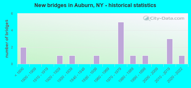
- New bridges - historical statistics
- 2Before 1900
- 11920-1929
- 11930-1939
- 11950-1959
- 51970-1979
- 11980-1989
- 11990-1999
- 32010-2019
- 12020-2022
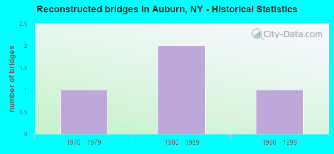
- Reconstructed bridges - Historical Statistics
- 11970-1979
- 21980-1989
- 11990-1999

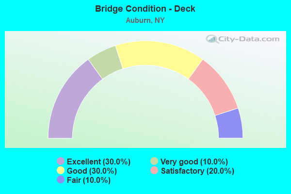
- Bridge Condition - Deck
- 30.0%Excellent
- 10.0%Very good
- 30.0%Good
- 20.0%Satisfactory
- 10.0%Fair
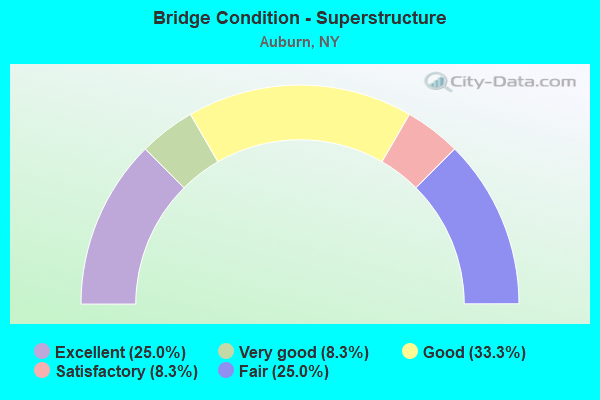
- Bridge Condition - Superstructure
- 25.0%Excellent
- 8.3%Very good
- 33.3%Good
- 8.3%Satisfactory
- 25.0%Fair
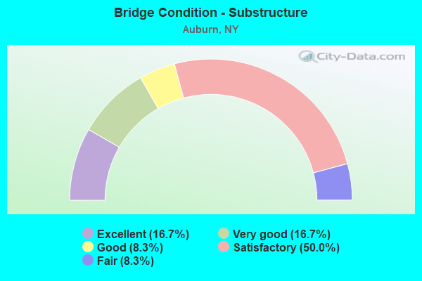
- Bridge Condition - Substructure
- 16.7%Excellent
- 16.7%Very good
- 8.3%Good
- 50.0%Satisfactory
- 8.3%Fair
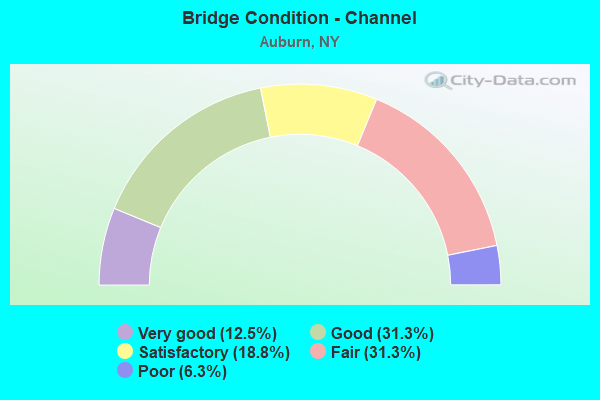
- Bridge Condition - Channel
- 12.5%Very good
- 31.3%Good
- 18.8%Satisfactory
- 31.3%Fair
- 6.3%Poor
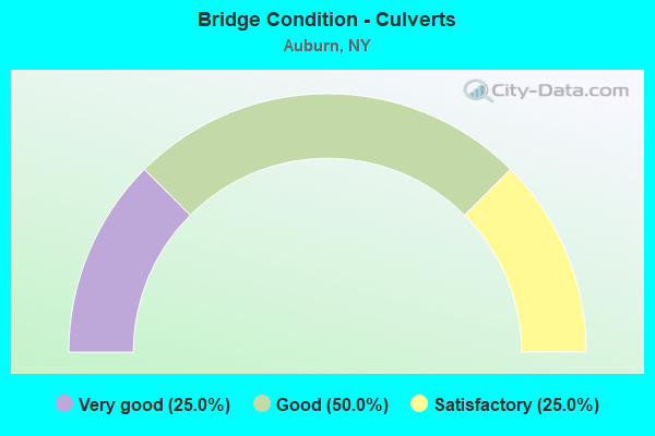
- Bridge Condition - Culverts
- 25.0%Very good
- 50.0%Good
- 25.0%Satisfactory
Find on map >> Show street view
Structure Number: 1068921, Location: JCT RTE 5 + OWASCO OUTLET (Lat: 42.933942, Lng: -76.568750), Route carried "on" structure: State highway 5, Year Built: 1976, Status: Open, Structure Length: 4.18m (13.71ft), Average Daily Traffic: 8,219 (year 2016), Truck Traffic: 6%, Average Future Daily Traffic: 8,257 (year 2040), Design Load: HS 20, Features Intersected: OWASCO OUTLET
Minimum Vertical Clearance: 30+ m (98+ ft), Kilometerpoint: 42.156, Lanes on structure: 4, Base Highway Network: Yes, Owner: State Highway Agency, Approaching Roadway Width: 15.5m (50.9ft), Skew: 4 degrees, Material/Design: Steel, Design/Construction: Stringer/Multi-beam, Number Of Spans In Main Unit: 1, Length of Maximum Span: 39.9m (130.9ft), Curb or Sidewalk Widths: Left: 1.5m (4.9ft), Right: 1.5m (4.9ft), Curb-To-Curb Width: 15.5m (50.9ft), Out-to-Out Width: 19.2m (63.0ft)
Condition: Deck: Good, Superstructure: Good, Substructure: Satisfactory, Channel: Good, Operating Rating: 83.5 metric tons, Method Used To Determine Operating Rating: Load Factor (LF), Inventory Rating: 49.9 metric tons, Method Used To Determine Inventory Rating: Load Factor (LF), Structural Evaluation: Equal to present minimum criteria, Deck Geometry: Meets minimum limits, Waterway Adequacy: Somewhat better than minimum adequacy, Approach Roadway Alignment: Superior to present desirable criteria, Length Of Structure Improvement: 4.17m (13.68ft), Designated Inspection Frequency: Every 24 months, Inspection Date: September 2021, Bridge Improvement Cost: $2,049,000, Roadway Improvement Cost: $1,200,000, Total Project Cost: $3,249,000 ( Estimate for 2021), Deck Structure Type: Concrete Cast-file-Place, Wearing Surface/Protective System: Wearing Surface: Integral Concrete
Find on map >> Show street view
Structure Number: 1068922, Location: JCT RTE 5 + OWASCO OUTLET (Lat: 42.933247, Lng: -76.566983), Route carried "on" structure: State highway 5, Year Built: 1976, Year Reconstructed: 2002, Status: Open, Structure Length: 3.75m (12.30ft), Average Daily Traffic: 8,721 (year 2012), Truck Traffic: 5%, Average Future Daily Traffic: 8,761 (year 2040), Design Load: HS 20, Features Intersected: OWASCO OUTLET
Minimum Vertical Clearance: 30+ m (98+ ft), Kilometerpoint: 15.575, Lanes on structure: 3, Base Highway Network: Yes, Owner: State Highway Agency, Approaching Roadway Width: 11.9m (39.0ft), Skew: 4 degrees, Material/Design: Steel, Design/Construction: Stringer/Multi-beam, Number Of Spans In Main Unit: 1, Length of Maximum Span: 36.5m (119.8ft), Curb or Sidewalk Widths: Left: 1.5m (4.9ft), Right: 1.5m (4.9ft), Curb-To-Curb Width: 11.9m (39.0ft), Out-to-Out Width: 15.5m (50.9ft)
Condition: Deck: Good, Superstructure: Good, Substructure: Satisfactory, Channel: Good, Operating Rating: 88.0 metric tons, Method Used To Determine Operating Rating: Load Factor (LF), Inventory Rating: 52.6 metric tons, Method Used To Determine Inventory Rating: Load Factor (LF), Structural Evaluation: Equal to present minimum criteria, Deck Geometry: High priority of corrective action, Waterway Adequacy: Somewhat better than minimum adequacy, Approach Roadway Alignment: Superior to present desirable criteria, Length Of Structure Improvement: 3.74m (12.27ft), Designated Inspection Frequency: Every 24 months, Inspection Date: October 2021, Bridge Improvement Cost: $1,417,000, Roadway Improvement Cost: $830,000, Total Project Cost: $2,247,000 ( Estimate for 2021), Deck Structure Type: Concrete Cast-file-Place, Wearing Surface/Protective System: Wearing Surface: Integral Concrete
Find on map >> Show street view
Structure Number: 120716, Location: 0.7 MI W JCT RTS 326 & 20 (Lat: 42.919353, Lng: -76.591781), Route carried "on" structure: City street , Year Built: 1975, Status: Open, Structure Length: 1.13m (3.71ft), Average Daily Traffic: 6,396 (year 2019), Truck Traffic: 5%, Average Future Daily Traffic: 6,426 (year 2040), Design Load: HS 20, Features Intersected: CRANE BROOK, Facility Carried by Structure: GENESEE STREET
Minimum Vertical Clearance: 30+ m (98+ ft), Kilometerpoint: 0.048, Lanes on structure: 4, Owner: State Highway Agency, Approaching Roadway Width: 14.6m (47.9ft), Material/Design: Steel, Design/Construction: Culvert, Number Of Spans In Main Unit: 2, Length of Maximum Span: 5.1m (16.7ft), Curb or Sidewalk Widths: Left: 1.5m (4.9ft), Right: 1.5m (4.9ft)
Condition: Channel: Fair, Culverts: Good, Operating Rating: 75.8 metric tons, Method Used To Determine Operating Rating: Field evaluation and documented engineering judgment, Inventory Rating: 29.4 metric tons, Method Used To Determine Inventory Rating: Field evaluation and documented engineering judgment, Structural Evaluation: Better than present minimum criteria, Waterway Adequacy: Somewhat better than minimum adequacy, Approach Roadway Alignment: Equal to present desirable criteria, Length Of Structure Improvement: 1.03m (3.38ft), Designated Inspection Frequency: Every 24 months, Inspection Date: May 2021, Bridge Improvement Cost: $351,000, Roadway Improvement Cost: $206,000, Total Project Cost: $557,000 ( Estimate for 2021)
Find on map >> Show street view
Structure Number: 220705, Location: 1.1MI SE STATE PRISON IN (Lat: 42.926558, Lng: -76.554264), Route carried "on" structure: City street , Year Built: 1954, Year Reconstructed: 1984, Status: Open, Structure Length: 8.17m (26.80ft), Average Daily Traffic: 7,906 (year 2019), Truck Traffic: 1%, Average Future Daily Traffic: 9,604 (year 2040), Features Intersected: OWASCO OUTLET, Facility Carried by Structure: LAKE AVENUE
Minimum Vertical Clearance: 30+ m (98+ ft), Kilometerpoint: 1.657, Lanes on structure: 4, Owner: City or Municipal Highway Agency, Approaching Roadway Width: 14.6m (47.9ft), Material/Design: Steel continuous, Design/Construction: Girder and Floorbeam System, Number Of Spans In Main Unit: 3, Length of Maximum Span: 36.5m (119.8ft), Curb or Sidewalk Widths: Left: 2.4m (7.9ft), Right: 2.4m (7.9ft), Curb-To-Curb Width: 14.6m (47.9ft), Out-to-Out Width: 20.0m (65.6ft)
Condition: Deck: Satisfactory, Superstructure: Fair, Substructure: Satisfactory, Channel: Good, Operating Rating: 75.8 metric tons, Method Used To Determine Operating Rating: Field evaluation and documented engineering judgment, Inventory Rating: 29.3 metric tons, Method Used To Determine Inventory Rating: Field evaluation and documented engineering judgment, Structural Evaluation: Somewhat better than minimum adequacy, Deck Geometry: High priority of replacement, Waterway Adequacy: Equal to present minimum criteria, Approach Roadway Alignment: Equal to present desirable criteria, Length Of Structure Improvement: 8.16m (26.77ft), Designated Inspection Frequency: Every 24 months, Critical Feature Inspection Frequency: Every 24 months, Inspection Date: August 2021, Critical Feature Inspection Date: August 2021, Bridge Improvement Cost: $3,615,000, Roadway Improvement Cost: $2,117,000, Total Project Cost: $5,732,000 ( Estimate for 2021), Deck Structure Type: Concrete Cast-file-Place, Wearing Surface/Protective System: Wearing Surface: Bituminous
Find on map >> Show street view
Structure Number: 220707, Location: IN AUBURN (Lat: 42.932697, Lng: -76.564217), Route carried "on" structure: City street , Year Built: 1880, Year Reconstructed: 1989, Status: Open, Structure Length: 3.11m (10.20ft), Average Daily Traffic: 6,108 (year 2016), Truck Traffic: 3%, Average Future Daily Traffic: 6,136 (year 2040), Design Load: HS 20, Features Intersected: OWASCO OUTLET, Facility Carried by Structure: GENESEE STREET
Minimum Vertical Clearance: 30+ m (98+ ft), Kilometerpoint: 2.719, Lanes on structure: 4, Owner: City or Municipal Highway Agency, Approaching Roadway Width: 19.5m (64.0ft), Skew: 3 degrees, Material/Design: Steel continuous, Design/Construction: Stringer/Multi-beam, Number Of Spans In Main Unit: 2, Length of Maximum Span: 17.7m (58.1ft), Curb or Sidewalk Widths: Left: 3.4m (11.2ft), Right: 3.4m (11.2ft), Curb-To-Curb Width: 19.5m (64.0ft), Out-to-Out Width: 26.8m (87.9ft)
Condition: Deck: Satisfactory, Superstructure: Good, Substructure: Satisfactory, Channel: Fair, Operating Rating: 59.0 metric tons, Method Used To Determine Operating Rating: Load Factor (LF), Inventory Rating: 35.4 metric tons, Method Used To Determine Inventory Rating: Load Factor (LF), Structural Evaluation: Equal to present minimum criteria, Deck Geometry: Better than present minimum criteria, Waterway Adequacy: Equal to present minimum criteria, Approach Roadway Alignment: Equal to present desirable criteria, Length Of Structure Improvement: 3.10m (10.17ft), Designated Inspection Frequency: Every 24 months, Inspection Date: December 2021, Bridge Improvement Cost: $2,669,000, Roadway Improvement Cost: $1,563,000, Total Project Cost: $4,232,000 ( Estimate for 2021), Deck Structure Type: Concrete Cast-file-Place, Wearing Surface/Protective System: Wearing Surface: Bituminous, Deck Protection: Epoxy Coated Reinforcing
Find on map >> Show street view
Structure Number: 220709, Location: RTE 38-200 FT FROM RTE 5 (Lat: 42.934328, Lng: -76.570281), Route carried "on" structure: City street 38, Year Built: 2020, Status: Open, Structure Length: 2.35m (7.71ft), Average Daily Traffic: 4,510 (year 2016), Truck Traffic: 4%, Average Future Daily Traffic: 5,580 (year 2040), Features Intersected: OWASCO OUTLET
Minimum Vertical Clearance: 30+ m (98+ ft), Kilometerpoint: 42.333, Lanes on structure: 2, Base Highway Network: Yes, Owner: City or Municipal Highway Agency, Approaching Roadway Width: 15.8m (51.8ft), Skew: 1 degrees, Material/Design: Steel, Design/Construction: Stringer/Multi-beam, Number Of Spans In Main Unit: 1, Length of Maximum Span: 22.2m (72.8ft), Curb or Sidewalk Widths: Left: 3.4m (11.2ft), Right: 3.4m (11.2ft), Curb-To-Curb Width: 15.8m (51.8ft), Out-to-Out Width: 22.6m (74.1ft)
Condition: Deck: Excellent, Superstructure: Excellent, Substructure: Very good, Channel: Good, Operating Rating: 98.9 metric tons, Method Used To Determine Operating Rating: Load Factor (LF), Inventory Rating: 59.0 metric tons, Method Used To Determine Inventory Rating: Load Factor (LF), Structural Evaluation: Equal to present desirable criteria, Deck Geometry: Superior to present desirable criteria, Waterway Adequacy: Meets minimum limits, Approach Roadway Alignment: Equal to present desirable criteria, Length Of Structure Improvement: 2.34m (7.68ft), Designated Inspection Frequency: Every 24 months, Inspection Date: July 2021, Bridge Improvement Cost: $2,058,000, Roadway Improvement Cost: $1,205,000, Total Project Cost: $3,264,000 ( Estimate for 2021), Deck Structure Type: Concrete Cast-file-Place, Wearing Surface/Protective System: Wearing Surface: Integral Concrete, Deck Protection: Epoxy Coated Reinforcing
Find on map >> Show street view
Structure Number: 22071, Location: .5 MI W JCT US 20 & SH 34 (Lat: 42.931839, Lng: -76.576575), Route carried "on" structure: City street , Year Built: 1996, Status: Open, Structure Length: 0.98m (3.22ft), Average Daily Traffic: 2,356 (year 2015), Truck Traffic: 2%, Average Future Daily Traffic: 2,915 (year 2040), Design Load: HS 25 or greater, Features Intersected: OWASCO RIVER RACE, Facility Carried by Structure: WASHINGTON ST
Minimum Vertical Clearance: 30+ m (98+ ft), Kilometerpoint: 0.499, Lanes on structure: 2, Owner: City or Municipal Highway Agency, Approaching Roadway Width: 9.1m (29.9ft), Material/Design: Concrete, Design/Construction: Frame, Number Of Spans In Main Unit: 1, Length of Maximum Span: 9.4m (30.8ft), Curb or Sidewalk Widths: Left: 2.2m (7.2ft), Right: 2.8m (9.2ft), Curb-To-Curb Width: 9.1m (29.9ft), Out-to-Out Width: 14.6m (47.9ft)
Condition: Deck: Good, Superstructure: Good, Substructure: Good, Channel: Fair, Operating Rating: 68.0 metric tons, Method Used To Determine Operating Rating: Load Factor (LF), Inventory Rating: 40.8 metric tons, Method Used To Determine Inventory Rating: Load Factor (LF), Structural Evaluation: Better than present minimum criteria, Deck Geometry: Meets minimum limits, Waterway Adequacy: Somewhat better than minimum adequacy, Approach Roadway Alignment: Equal to present desirable criteria, Length Of Structure Improvement: 0.97m (3.18ft), Designated Inspection Frequency: Every 24 months, Inspection Date: July 2020, Bridge Improvement Cost: $620,000, Roadway Improvement Cost: $363,000, Total Project Cost: $983,000 ( Estimate for 2021), Wearing Surface/Protective System: Wearing Surface: Bituminous
Find on map >> Show street view
Structure Number: 220711, Location: 3 MI E JCT US 20 & SH 326 (Lat: 42.932144, Lng: -76.576717), Route carried "on" structure: City street , Year Built: 1925, Year Reconstructed: 1993, Status: Open, Structure Length: 2.01m (6.59ft), Average Daily Traffic: 2,356 (year 2015), Truck Traffic: 2%, Average Future Daily Traffic: 2,915 (year 2040), Design Load: HS 25 or greater, Features Intersected: OWASCO OUTLET, Facility Carried by Structure: WASHINGTON ST
Minimum Vertical Clearance: 30+ m (98+ ft), Kilometerpoint: 0.547, Lanes on structure: 2, Owner: City or Municipal Highway Agency, Approaching Roadway Width: 9.1m (29.9ft), Skew: 2 degrees, Material/Design: Prestressed concrete, Design/Construction: Box Beam or Girders - Multiple, Number Of Spans In Main Unit: 1, Length of Maximum Span: 19.2m (63.0ft), Curb or Sidewalk Widths: Left: 2.8m (9.2ft), Right: 2.8m (9.2ft), Curb-To-Curb Width: 9.1m (29.9ft), Out-to-Out Width: 15.2m (49.9ft)
Condition: Deck: Very good, Superstructure: Very good, Substructure: Very good, Channel: Satisfactory, Operating Rating: 89.8 metric tons, Method Used To Determine Operating Rating: Load Factor (LF), Inventory Rating: 41.7 metric tons, Method Used To Determine Inventory Rating: Load Factor (LF), Structural Evaluation: Equal to present desirable criteria, Deck Geometry: Meets minimum limits, Waterway Adequacy: Somewhat better than minimum adequacy, Approach Roadway Alignment: Equal to present desirable criteria, Length Of Structure Improvement: 2.01m (6.59ft), Designated Inspection Frequency: Every 24 months, Inspection Date: July 2020, Bridge Improvement Cost: $1,156,000, Roadway Improvement Cost: $677,000, Total Project Cost: $1,833,000 ( Estimate for 2021), Wearing Surface/Protective System: Wearing Surface: Monolithic Concrete
Find on map >> Show street view
Structure Number: 220712, Location: .5 MI SW OF STATE PRISON (Lat: 42.932147, Lng: -76.584481), Route carried "on" structure: City street , Year Built: 2019, Status: Open, Structure Length: 5.39m (17.68ft), Average Daily Traffic: 4,058 (year 2014), Truck Traffic: 3%, Average Future Daily Traffic: 4,929 (year 2040), Design Load: HL 93, Features Intersected: OWASCO OUTLET, Facility Carried by Structure: NORTH DIVISION STR
Minimum Vertical Clearance: 32.69m (107.25ft), Kilometerpoint: 0.032, Lanes on structure: 2, Owner: City or Municipal Highway Agency, Approaching Roadway Width: 9.8m (32.2ft), Skew: 2 degrees, Material/Design: Steel continuous, Design/Construction: Stringer/Multi-beam, Number Of Spans In Main Unit: 2, Length of Maximum Span: 27.4m (89.9ft), Curb or Sidewalk Widths: Left: 1.7m (5.6ft), Right: 1.7m (5.6ft), Curb-To-Curb Width: 9.8m (32.2ft), Out-to-Out Width: 14.1m (46.3ft)
Condition: Deck: Excellent, Superstructure: Excellent, Substructure: Excellent, Channel: Very good, Operating Rating: 90.4 metric tons, Method Used To Determine Operating Rating: Field evaluation and documented engineering judgment, Inventory Rating: 40.8 metric tons, Method Used To Determine Inventory Rating: Field evaluation and documented engineering judgment, Structural Evaluation: Superior to present desirable criteria, Deck Geometry: Meets minimum limits, Waterway Adequacy: Superior to present desirable criteria, Approach Roadway Alignment: Meets minimum limits, Length Of Structure Improvement: 5.39m (17.68ft), Designated Inspection Frequency: Every 24 months, Inspection Date: November 2021, Bridge Improvement Cost: $1,731,000, Roadway Improvement Cost: $1,013,000, Total Project Cost: $2,744,000 ( Estimate for 2021), Deck Structure Type: Concrete Cast-file-Place, Wearing Surface/Protective System: Wearing Surface: Integral Concrete, Deck Protection: Epoxy Coated Reinforcing
Find on map >> Show street view
Structure Number: 220713, Location: 0.2MI NE JCT20<326 AUBURN (Lat: 42.934372, Lng: -76.587581), Route carried "on" structure: City street , Year Built: 1886, Status: Open, Structure Length: 3.05m (10.01ft), Average Daily Traffic: 2,111 (year 2016), Truck Traffic: 5%, Average Future Daily Traffic: 2,955 (year 2036), Features Intersected: OWASCO OUTLET, Facility Carried by Structure: AURELIUS AVENUE
Minimum Vertical Clearance: 30+ m (98+ ft), Kilometerpoint: 0.225, Lanes on structure: 2, Owner: City or Municipal Highway Agency, Approaching Roadway Width: 7.6m (24.9ft), Material/Design: Masonry, Design/Construction: Arch - Deck, Number Of Spans In Main Unit: 2, Length of Maximum Span: 12.1m (39.7ft), Curb or Sidewalk Widths: Left: 1.7m (5.6ft), Right: 1.7m (5.6ft), Curb-To-Curb Width: 7.3m (24.0ft), Out-to-Out Width: 13.0m (42.7ft)
Condition: Superstructure: Fair, Substructure: Fair, Channel: Fair, Operating Rating: 40.6 metric tons, Method Used To Determine Operating Rating: Field evaluation and documented engineering judgment, Inventory Rating: 11.2 metric tons, Method Used To Determine Inventory Rating: Field evaluation and documented engineering judgment, Structural Evaluation: High priority of corrective action, Deck Geometry: High priority of replacement, Waterway Adequacy: Meets minimum limits, Approach Roadway Alignment: Meets minimum limits, Length Of Structure Improvement: 3.04m (9.97ft), Designated Inspection Frequency: Every 24 months, Inspection Date: September 2021, Bridge Improvement Cost: $2,129,000, Roadway Improvement Cost: $1,247,000, Total Project Cost: $3,376,000 ( Estimate for 2021)
Find on map >> Show street view
Structure Number: 220714, Location: .2 MI NE JCT US20 & SH326 (Lat: 42.937539, Lng: -76.593903), Route carried "on" structure: City street , Year Built: 1930, Status: Open, Structure Length: 3.35m (10.99ft), Average Daily Traffic: 631 (year 2020), Truck Traffic: 4%, Average Future Daily Traffic: 883 (year 2040), Features Intersected: OWASCO OUTLET, Facility Carried by Structure: CANOGA STREET
Minimum Vertical Clearance: 30+ m (98+ ft), Kilometerpoint: 0.129, Lanes on structure: 2, Owner: City or Municipal Highway Agency, Approaching Roadway Width: 8.2m (26.9ft), Skew: 1 degrees, Material/Design: Concrete, Design/Construction: Arch - Deck, Number Of Spans In Main Unit: 1, Length of Maximum Span: 21.3m (69.9ft), Curb or Sidewalk Widths: Left: 1.4m (4.6ft), Right: 1.4m (4.6ft), Curb-To-Curb Width: 8.3m (27.2ft), Out-to-Out Width: 12.1m (39.7ft)
Condition: Superstructure: Fair, Substructure: Satisfactory, Channel: Satisfactory, Operating Rating: 56.2 metric tons, Method Used To Determine Operating Rating: Field evaluation and documented engineering judgment, Inventory Rating: 14.0 metric tons, Method Used To Determine Inventory Rating: Field evaluation and documented engineering judgment, Structural Evaluation: Meets minimum limits, Deck Geometry: Somewhat better than minimum adequacy, Waterway Adequacy: Somewhat better than minimum adequacy, Approach Roadway Alignment: Better than present minimum criteria, Length Of Structure Improvement: 3.35m (10.99ft), Designated Inspection Frequency: Every 24 months, Inspection Date: August 2021, Bridge Improvement Cost: $1,900,000, Roadway Improvement Cost: $1,113,000, Total Project Cost: $3,012,000 ( Estimate for 2021), Wearing Surface/Protective System: Wearing Surface: Bituminous
Find on map >> Show street view
Structure Number: 226795, Location: 0.5 M S OF JUNC US20&US5 (Lat: 42.928981, Lng: -76.558603), Route carried "on" structure: City street , Year Built: 1978, Status: Open, Structure Length: 0.82m (2.69ft), Average Daily Traffic: 42 (year 2020), Truck Traffic: 4%, Average Future Daily Traffic: 59 (year 2040), Design Load: HS 20, Features Intersected: OWASCO POWER RACE, Facility Carried by Structure: MILLER STREET
Minimum Vertical Clearance: 30+ m (98+ ft), Kilometerpoint: 0.322, Lanes on structure: 2, Owner: City or Municipal Highway Agency, Approaching Roadway Width: 6.1m (20.0ft), Material/Design: Concrete, Design/Construction: Slab, Number Of Spans In Main Unit: 1, Length of Maximum Span: 7.6m (24.9ft), Curb or Sidewalk Widths: Left: 1.8m (5.9ft), Right: 1.8m (5.9ft), Curb-To-Curb Width: 6.1m (20.0ft), Out-to-Out Width: 9.8m (32.2ft)
Condition: Deck: Fair, Superstructure: Satisfactory, Substructure: Satisfactory, Channel: Good, Operating Rating: 93.4 metric tons, Method Used To Determine Operating Rating: Load Factor (LF), Inventory Rating: 56.2 metric tons, Method Used To Determine Inventory Rating: Load Factor (LF), Structural Evaluation: Equal to present minimum criteria, Deck Geometry: Somewhat better than minimum adequacy, Waterway Adequacy: Better than present minimum criteria, Approach Roadway Alignment: Equal to present desirable criteria, Length Of Structure Improvement: 0.82m (2.69ft), Designated Inspection Frequency: Every 24 months, Inspection Date: November 2021, Bridge Improvement Cost: $390,000, Roadway Improvement Cost: $228,000, Total Project Cost: $618,000 ( Estimate for 2021), Deck Structure Type: Concrete Cast-file-Place, Wearing Surface/Protective System: Wearing Surface: Integral Concrete, Deck Protection: Epoxy Coated Reinforcing
Find on map >> Show street view
Structure Number: 226843, Location: 0.5 MI WEST OF NYS RT 5 (Lat: 42.946089, Lng: -76.553317), Route carried "on" structure: ServiceCity street , Year Built: 2018, Status: Open, Structure Length: 0.84m (2.76ft), Average Daily Traffic: 869 (year 2016), Truck Traffic: 4%, Average Future Daily Traffic: 1,217 (year 2036), Features Intersected: HUNTER BROOK, Facility Carried by Structure: SCHWARTZ DRIVE
Minimum Vertical Clearance: 30+ m (98+ ft), Kilometerpoint: 0.225, Lanes on structure: 2, Owner: City or Municipal Highway Agency, Approaching Roadway Width: 8.8m (28.9ft), Skew: 2 degrees, Material/Design: Concrete, Design/Construction: Frame, Number Of Spans In Main Unit: 1, Length of Maximum Span: 7.8m (25.6ft), Curb or Sidewalk Widths: Left: 1.2m (3.9ft), Right: 1.2m (3.9ft), Curb-To-Curb Width: 8.8m (28.9ft), Out-to-Out Width: 23.2m (76.1ft)
Condition: Deck: Excellent, Superstructure: Excellent, Substructure: Excellent, Channel: Satisfactory, Operating Rating: 31.8 metric tons, Method Used To Determine Operating Rating: Load Factor (LF), Inventory Rating: 24.5 metric tons, Method Used To Determine Inventory Rating: Load Factor (LF), Structural Evaluation: Equal to present minimum criteria, Deck Geometry: Somewhat better than minimum adequacy, Waterway Adequacy: Meets minimum limits, Approach Roadway Alignment: Equal to present desirable criteria, Length Of Structure Improvement: 0.84m (2.76ft), Designated Inspection Frequency: Every 24 months, Inspection Date: August 2020, Bridge Improvement Cost: $453,000, Roadway Improvement Cost: $265,000, Total Project Cost: $719,000 ( Estimate for 2021), Wearing Surface/Protective System: Wearing Surface: Bituminous
Find on map >> Show street view
Structure Number: 226844, Location: 0.3 MI WEST OF NYS RT 5 (Lat: 42.947875, Lng: -76.553225), Route carried "on" structure: ServiceCity street , Year Built: 2018, Status: Open, Structure Length: 0.79m (2.59ft), Average Daily Traffic: 3,529 (year 2016), Truck Traffic: 2%, Average Future Daily Traffic: 4,941 (year 2036), Features Intersected: HUNTER BROOK, Facility Carried by Structure: MCINTOSH DRIVE
Minimum Vertical Clearance: 30+ m (98+ ft), Kilometerpoint: 0.451, Lanes on structure: 2, Owner: City or Municipal Highway Agency, Approaching Roadway Width: 9.4m (30.8ft), Material/Design: Concrete, Design/Construction: Culvert, Number Of Spans In Main Unit: 1, Length of Maximum Span: 7.3m (24.0ft), Curb or Sidewalk Widths: Left: 1.2m (3.9ft), Right: 1.2m (3.9ft), Curb-To-Curb Width: 9.4m (30.8ft), Out-to-Out Width: 22.3m (73.2ft)
Condition: Channel: Very good, Culverts: Very good, Operating Rating: 77.7 metric tons, Method Used To Determine Operating Rating: Field evaluation and documented engineering judgment, Inventory Rating: 40.8 metric tons, Method Used To Determine Inventory Rating: Field evaluation and documented engineering judgment, Structural Evaluation: Equal to present desirable criteria, Deck Geometry: Meets minimum limits, Waterway Adequacy: Meets minimum limits, Approach Roadway Alignment: Equal to present desirable criteria, Length Of Structure Improvement: 0.79m (2.59ft), Designated Inspection Frequency: Every 24 months, Inspection Date: August 2020, Bridge Improvement Cost: $409,000, Roadway Improvement Cost: $239,000, Total Project Cost: $648,000 ( Estimate for 2021), Wearing Surface/Protective System: Wearing Surface: Bituminous
Find on map >> Show street view
Structure Number: 226845, Location: 0.6 MI NORTH OF NYS RT 20 (Lat: 42.940653, Lng: -76.546369), Route carried "on" structure: ServiceCity street , Year Built: 1985, Status: Open, Structure Length: 0.73m (2.40ft), Average Daily Traffic: 6,166 (year 2018), Truck Traffic: 3%, Average Future Daily Traffic: 7,629 (year 2040), Features Intersected: HUNTER BROOK, Facility Carried by Structure: FRANKLIN STREET
Minimum Vertical Clearance: 30+ m (98+ ft), Kilometerpoint: 1.303, Lanes on structure: 2, Owner: City or Municipal Highway Agency, Approaching Roadway Width: 11.0m (36.1ft), Material/Design: Concrete, Design/Construction: Culvert, Number Of Spans In Main Unit: 2, Length of Maximum Span: 3.3m (10.8ft), Curb or Sidewalk Widths: Left: 2.2m (7.2ft), Right: 2.5m (8.2ft)
Condition: Channel: Poor, Culverts: Good, Operating Rating: 74.9 metric tons, Method Used To Determine Operating Rating: Field evaluation and documented engineering judgment, Inventory Rating: 32.7 metric tons, Method Used To Determine Inventory Rating: Field evaluation and documented engineering judgment, Structural Evaluation: Better than present minimum criteria, Waterway Adequacy: Meets minimum limits, Approach Roadway Alignment: Equal to present desirable criteria, Length Of Structure Improvement: 0.73m (2.40ft), Designated Inspection Frequency: Every 24 months, Inspection Date: March 2021, Bridge Improvement Cost: $279,000, Roadway Improvement Cost: $163,000, Total Project Cost: $443,000 ( Estimate for 2021)
Find on map >> Show street view
Structure Number: 226879, Location: 0.3MI SE OF NYSRT20&RT326 (Lat: 42.925489, Lng: -76.591414), Route carried "on" structure: City street , Year Built: 1973, Status: Open, Structure Length: 1.40m (4.59ft), Average Daily Traffic: 1,048 (year 2020), Truck Traffic: 6%, Average Future Daily Traffic: 1,467 (year 2040), Features Intersected: CRANE BROOK, Facility Carried by Structure: WRIGHT AVENUE
Minimum Vertical Clearance: 30+ m (98+ ft), Kilometerpoint: 0.225, Lanes on structure: 2, Owner: City or Municipal Highway Agency, Approaching Roadway Width: 14.6m (47.9ft), Skew: 4 degrees, Material/Design: Steel, Design/Construction: Culvert, Number Of Spans In Main Unit: 2, Length of Maximum Span: 5.1m (16.7ft)
Condition: Channel: Fair, Culverts: Satisfactory, Operating Rating: 75.8 metric tons, Method Used To Determine Operating Rating: Field evaluation and documented engineering judgment, Inventory Rating: 29.4 metric tons, Method Used To Determine Inventory Rating: Field evaluation and documented engineering judgment, Structural Evaluation: Equal to present minimum criteria, Waterway Adequacy: Meets minimum limits, Approach Roadway Alignment: Equal to present desirable criteria, Length Of Structure Improvement: 1.40m (4.59ft), Designated Inspection Frequency: Every 24 months, Inspection Date: July 2020, Bridge Improvement Cost: $475,000, Roadway Improvement Cost: $278,000, Total Project Cost: $753,000 ( Estimate for 2021), Wearing Surface/Protective System: Wearing Surface: Bituminous