Bridge Statistics for Audubon, Pennsylvania (PA)
Condition, Traffic, Stress, Structural Evaluation, Project Costs
- National Bridge Inventory (NBI) Statistics
- 29Number of bridges
- 443ft / 135mTotal length
- $2,323,000Total costs
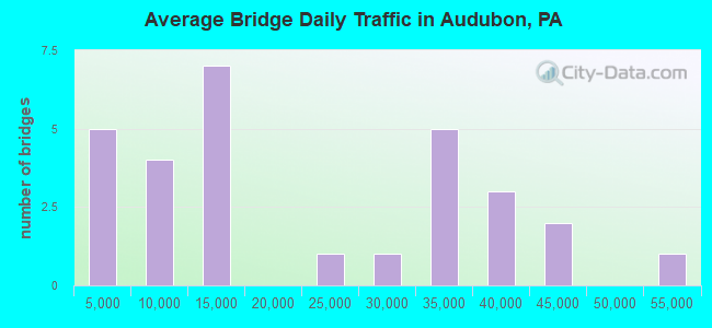
- 590,064Total average daily traffic
- 52,051Total average daily truck traffic
- National Bridge Inventory (NBI) Registered Bridges for Audubon
- No street view available for this location
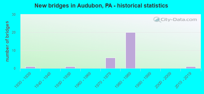
- New bridges - historical statistics
- 11930-1939
- 11950-1959
- 61970-1979
- 201980-1989
- 12010-2019
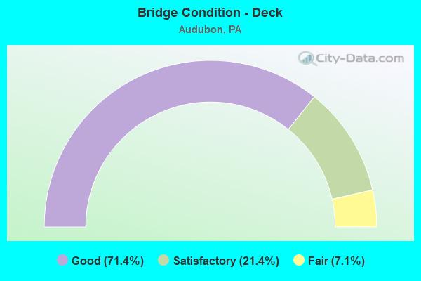
- Bridge Condition - Deck
- 71.4%Good
- 21.4%Satisfactory
- 7.1%Fair
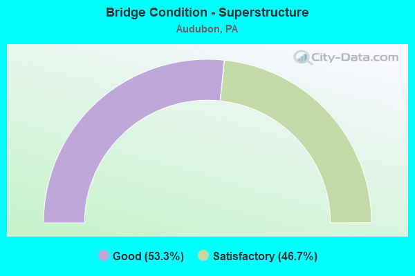
- Bridge Condition - Superstructure
- 53.3%Good
- 46.7%Satisfactory
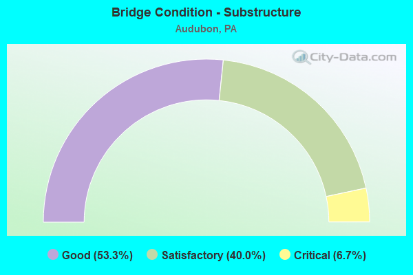
- Bridge Condition - Substructure
- 53.3%Good
- 40.0%Satisfactory
- 6.7%Critical
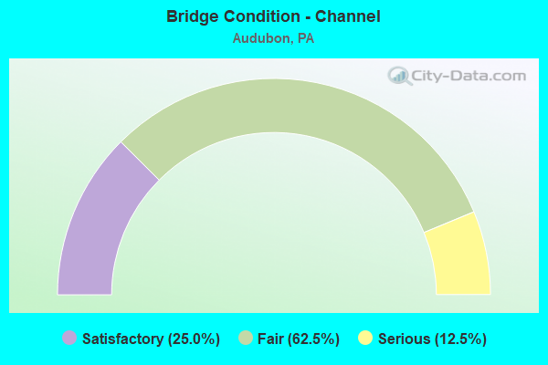
- Bridge Condition - Channel
- 25.0%Satisfactory
- 62.5%Fair
- 12.5%Serious
Find on map >> Show street view
Structure Number: 27137, Location: VAL FORGE PK 27B11/3365F5 (Lat: 40.099969, Lng: -75.462589), Route carried "on" structure: State highway 23, Year Built: 1934, Status: Open, Structure Length: 2.04m (6.69ft), Average Daily Traffic: 8,377 (year 2020), Truck Traffic: 8%, Average Future Daily Traffic: 23,117 (year 2032), Design Load: H 15, Features Intersected: VALLEY CREEK, Facility Carried by Structure: VALLEY FORGE ROAD
Minimum Vertical Clearance: 30+ m (98+ ft), Kilometerpoint: 0.000, Lanes on structure: 2, Owner: State Highway Agency, Approaching Roadway Width: 9.8m (32.2ft), Material/Design: Concrete, Design/Construction: Arch - Deck, Number Of Spans In Main Unit: 2, Length of Maximum Span: 9.1m (29.9ft), Curb or Sidewalk Widths: Left: 1.5m (4.9ft), Right: 1.5m (4.9ft), Curb-To-Curb Width: 9.8m (32.2ft), Out-to-Out Width: 13.7m (44.9ft)
Condition: Superstructure: Satisfactory, Substructure: Critical, Channel: Serious, Operating Rating: 61.7 metric tons, Method Used To Determine Operating Rating: Field evaluation and documented engineering judgment, Inventory Rating: 30.8 metric tons, Method Used To Determine Inventory Rating: Field evaluation and documented engineering judgment, Structural Evaluation: High priority of replacement, Deck Geometry: Meets minimum limits, Waterway Adequacy: Equal to present minimum criteria, Approach Roadway Alignment: Better than present minimum criteria, Length Of Structure Improvement: 2.60m (8.53ft), Designated Inspection Frequency: Every 24 months, Underwater Inspection Frequency: Every 6 months, Other Special Inspection Frequency: Every 6 months, Inspection Date: November 2019, Underwater Inspection Date: September 2021, Other Special Inspection Date: September 2021, Bridge Improvement Cost: $27,000, Roadway Improvement Cost: $78,000, Total Project Cost: $359,000, Deck Structure Type: Concrete Cast-file-Place
Find on map >> Show street view
Structure Number: 27403, Location: BETZWOOD 27J9/3366C3 (Lat: 40.112669, Lng: -75.420194), Route carried "on" structure: State highway 363, Year Built: 1974, Status: Open, Structure Length: 8.99m (29.49ft), Average Daily Traffic: 28,909 (year 2022), Truck Traffic: 4%, Average Future Daily Traffic: 38,028 (year 2032), Design Load: HS 20, Features Intersected: POTTSTOWN EXPRESSWAY, Facility Carried by Structure: TROOPER ROAD
Minimum Vertical Clearance: 30+ m (98+ ft), Kilometerpoint: 0.000, Lanes on structure: 2, Lanes under structure: 6, Base Highway Network: Yes, Owner: State Highway Agency, Approaching Roadway Width: 17.1m (56.1ft), Skew: 33 degrees, Material/Design: Steel, Design/Construction: Stringer/Multi-beam, Number Of Spans In Main Unit: 2, Number Of Approach Spans: 2, Length of Maximum Span: 34.1m (111.9ft), Curb or Sidewalk Widths: Left: 0.2m (0.7ft), Right: 0.2m (0.7ft), Curb-To-Curb Width: 17.1m (56.1ft), Out-to-Out Width: 18.3m (60.0ft)
Condition: Deck: Good, Superstructure: Good, Substructure: Good, Operating Rating: 68.9 metric tons, Method Used To Determine Operating Rating: Load Factor (LF), Inventory Rating: 40.8 metric tons, Method Used To Determine Inventory Rating: Load Factor (LF), Structural Evaluation: Better than present minimum criteria, Deck Geometry: Superior to present desirable criteria, Underclear: High priority of corrective action, Approach Roadway Alignment: Better than present minimum criteria, Length Of Structure Improvement: 10.10m (33.14ft), Designated Inspection Frequency: Every 24 months, Inspection Date: Febuary 2021, Bridge Improvement Cost: $65,000, Roadway Improvement Cost: $191,000, Total Project Cost: $875,000, Deck Structure Type: Concrete Cast-file-Place, Wearing Surface/Protective System: Wearing Surface: Epoxy Overlay, Deck Protection: Epoxy Coated Reinforcing
Find on map >> Show street view
Structure Number: 27439, Location: N. OF OAKS 27B01/3253E6 (Lat: 40.155433, Lng: -75.468092), Route carried "on" structure: US 422, Year Built: 1984, Status: Open, Structure Length: 5.30m (17.39ft), Average Daily Traffic: 37,586 (year 2022), Truck Traffic: 11%, Average Future Daily Traffic: 35,777 (year 2032), Design Load: HS 20, Features Intersected: TROUTMAN ROAD, Facility Carried by Structure: POTTSTOWN EWAY(EB)
Minimum Vertical Clearance: 30+ m (98+ ft), Kilometerpoint: 20.369, Lanes on structure: 2, Lanes under structure: 2, Base Highway Network: Yes, Owner: State Highway Agency, Approaching Roadway Width: 13.1m (43.0ft), Skew: 13 degrees, Material/Design: Prestressed concrete, Design/Construction: Stringer/Multi-beam, Number Of Spans In Main Unit: 3, Length of Maximum Span: 18.0m (59.1ft), Curb or Sidewalk Widths: Left: 0.2m (0.7ft), Right: 0.2m (0.7ft), Curb-To-Curb Width: 12.2m (40.0ft), Out-to-Out Width: 13.3m (43.6ft)
Condition: Deck: Good, Superstructure: Good, Substructure: Good, Operating Rating: 54.4 metric tons, Method Used To Determine Operating Rating: Load Factor (LF), Inventory Rating: 32.7 metric tons, Method Used To Determine Inventory Rating: Load Factor (LF), Structural Evaluation: Better than present minimum criteria, Deck Geometry: Better than present minimum criteria, Underclear: Somewhat better than minimum adequacy, Approach Roadway Alignment: Equal to present desirable criteria, Length Of Structure Improvement: 6.30m (20.67ft), Designated Inspection Frequency: Every 24 months, Inspection Date: Febuary 2021, Deck Structure Type: Concrete Cast-file-Place, Wearing Surface/Protective System: Wearing Surface: Monolithic Concrete, Deck Protection: Epoxy Coated Reinforcing
Find on map >> Show street view
Structure Number: 27441, Location: N. OF OAKS 27D3/3253H8 (Lat: 40.142381, Lng: -75.453544), Route carried "on" structure: US 422, Year Built: 1984, Status: Open, Structure Length: 4.85m (15.91ft), Average Daily Traffic: 37,586 (year 2022), Truck Traffic: 11%, Average Future Daily Traffic: 35,777 (year 2032), Design Load: HS 20, Features Intersected: UPPER INDIAN HEAD ROAD, Facility Carried by Structure: P-TOWN X-WAY (EB)
Minimum Vertical Clearance: 30+ m (98+ ft), Kilometerpoint: 22.314, Lanes on structure: 2, Lanes under structure: 2, Base Highway Network: Yes, Owner: State Highway Agency, Approaching Roadway Width: 13.7m (44.9ft), Skew: 13 degrees, Material/Design: Prestressed concrete, Design/Construction: Stringer/Multi-beam, Number Of Spans In Main Unit: 3, Length of Maximum Span: 23.2m (76.1ft), Curb or Sidewalk Widths: Left: 0.2m (0.7ft), Right: 0.2m (0.7ft), Curb-To-Curb Width: 12.9m (42.3ft), Out-to-Out Width: 14.1m (46.3ft)
Condition: Deck: Good, Superstructure: Good, Substructure: Good, Operating Rating: 68.0 metric tons, Method Used To Determine Operating Rating: Load Factor (LF), Inventory Rating: 38.1 metric tons, Method Used To Determine Inventory Rating: Load Factor (LF), Structural Evaluation: Better than present minimum criteria, Deck Geometry: Superior to present desirable criteria, Underclear: Superior to present desirable criteria, Approach Roadway Alignment: Equal to present desirable criteria, Length Of Structure Improvement: 5.80m (19.03ft), Designated Inspection Frequency: Every 24 months, Inspection Date: December 2020, Deck Structure Type: Concrete Cast-file-Place, Wearing Surface/Protective System: Wearing Surface: Monolithic Concrete, Deck Protection: Epoxy Coated Reinforcing
Find on map >> Show street view
Structure Number: 27442, Location: N. OF OAKS 27D3/3253H8 (Lat: 40.142511, Lng: -75.451847), Route carried "on" structure: US 422, Year Built: 1984, Status: Open, Structure Length: 4.91m (16.11ft), Average Daily Traffic: 41,147 (year 2022), Truck Traffic: 11%, Average Future Daily Traffic: 39,838 (year 2032), Design Load: HS 20, Features Intersected: UPPER INDIAN HEAD ROAD, Facility Carried by Structure: P-TOWN X-WAY (WB)
Minimum Vertical Clearance: 30+ m (98+ ft), Kilometerpoint: 22.405, Lanes on structure: 2, Lanes under structure: 2, Base Highway Network: Yes, Owner: State Highway Agency, Approaching Roadway Width: 13.7m (44.9ft), Skew: 13 degrees, Material/Design: Prestressed concrete, Design/Construction: Stringer/Multi-beam, Number Of Spans In Main Unit: 3, Length of Maximum Span: 23.2m (76.1ft), Curb or Sidewalk Widths: Left: 0.2m (0.7ft), Right: 0.2m (0.7ft), Curb-To-Curb Width: 13.0m (42.7ft), Out-to-Out Width: 14.1m (46.3ft)
Condition: Deck: Good, Superstructure: Satisfactory, Substructure: Satisfactory, Operating Rating: 68.0 metric tons, Method Used To Determine Operating Rating: Load Factor (LF), Inventory Rating: 37.2 metric tons, Method Used To Determine Inventory Rating: Load Factor (LF), Structural Evaluation: Equal to present minimum criteria, Deck Geometry: Superior to present desirable criteria, Underclear: Superior to present desirable criteria, Approach Roadway Alignment: Equal to present desirable criteria, Length Of Structure Improvement: 5.90m (19.36ft), Designated Inspection Frequency: Every 24 months, Inspection Date: December 2020, Deck Structure Type: Concrete Cast-file-Place, Wearing Surface/Protective System: Wearing Surface: Monolithic Concrete, Deck Protection: Epoxy Coated Reinforcing
Find on map >> Show street view
Structure Number: 27443, Location: OAKS 27E5/3253J9 (Lat: 40.134169, Lng: -75.447328), Route carried "on" structure: US 422, Year Built: 1982, Status: Open, Structure Length: 3.99m (13.09ft), Average Daily Traffic: 37,586 (year 2022), Truck Traffic: 11%, Average Future Daily Traffic: 35,777 (year 2032), Design Load: HS 20, Features Intersected: EGYPT ROAD, Facility Carried by Structure: P-TOWN X-WAY (EB)
Minimum Vertical Clearance: 30+ m (98+ ft), Kilometerpoint: 23.398, Lanes on structure: 3, Lanes under structure: 4, Base Highway Network: Yes, Owner: State Highway Agency, Approaching Roadway Width: 13.7m (44.9ft), Skew: 10 degrees, Material/Design: Steel, Design/Construction: Stringer/Multi-beam, Number Of Spans In Main Unit: 1, Length of Maximum Span: 39.6m (129.9ft), Curb or Sidewalk Widths: Left: 0.2m (0.7ft), Right: 0.2m (0.7ft), Curb-To-Curb Width: 15.8m (51.8ft), Out-to-Out Width: 16.9m (55.4ft)
Condition: Deck: Good, Superstructure: Good, Substructure: Satisfactory, Inventory Rating: 63.5 metric tons, Method Used To Determine Inventory Rating: Load Factor (LF), Structural Evaluation: Equal to present minimum criteria, Deck Geometry: Somewhat better than minimum adequacy, Underclear: Somewhat better than minimum adequacy, Approach Roadway Alignment: Equal to present desirable criteria, Length Of Structure Improvement: 4.80m (15.75ft), Designated Inspection Frequency: Every 24 months, Inspection Date: December 2020, Deck Structure Type: Concrete Cast-file-Place, Wearing Surface/Protective System: Wearing Surface: Monolithic Concrete, Deck Protection: Epoxy Coated Reinforcing
Find on map >> Show street view
Structure Number: 27444, Location: OAKS 27E5/3253J9 (Lat: 40.134253, Lng: -75.446903), Route carried "on" structure: US 422, Year Built: 1982, Status: Open, Structure Length: 3.99m (13.09ft), Average Daily Traffic: 41,147 (year 2022), Truck Traffic: 11%, Average Future Daily Traffic: 39,838 (year 2032), Design Load: HS 20, Features Intersected: EGYPT ROAD, Facility Carried by Structure: P-TOWN X-WAY (WB)
Minimum Vertical Clearance: 30+ m (98+ ft), Kilometerpoint: 23.434, Lanes on structure: 2, Lanes under structure: 4, Base Highway Network: Yes, Owner: State Highway Agency, Approaching Roadway Width: 13.7m (44.9ft), Skew: 10 degrees, Material/Design: Steel, Design/Construction: Stringer/Multi-beam, Number Of Spans In Main Unit: 1, Length of Maximum Span: 39.6m (129.9ft), Curb or Sidewalk Widths: Left: 0.2m (0.7ft), Right: 0.2m (0.7ft), Curb-To-Curb Width: 12.8m (42.0ft), Out-to-Out Width: 13.9m (45.6ft)
Condition: Deck: Good, Superstructure: Good, Substructure: Good, Inventory Rating: 66.2 metric tons, Method Used To Determine Inventory Rating: Load Factor (LF), Structural Evaluation: Better than present minimum criteria, Deck Geometry: Equal to present desirable criteria, Underclear: Equal to present minimum criteria, Approach Roadway Alignment: Equal to present desirable criteria, Length Of Structure Improvement: 4.80m (15.75ft), Designated Inspection Frequency: Every 24 months, Inspection Date: December 2020, Deck Structure Type: Concrete Cast-file-Place, Wearing Surface/Protective System: Wearing Surface: Monolithic Concrete, Deck Protection: Epoxy Coated Reinforcing
Find on map >> Show street view
Structure Number: 27445, Location: SOUTH OF OAKS 27D08 (Lat: 40.119878, Lng: -75.452897), Route carried "on" structure: US 422, Year Built: 1982, Status: Open, Structure Length: 25.12m (82.41ft), Average Daily Traffic: 33,442 (year 2022), Truck Traffic: 9%, Average Future Daily Traffic: 39,687 (year 2032), Design Load: HS 20, Features Intersected: PERKIOMEN CREEK/3365-H1, Facility Carried by Structure: POTTSTOWN EWAY(EB)
Minimum Vertical Clearance: 30+ m (98+ ft), Kilometerpoint: 24.998, Lanes on structure: 2, Base Highway Network: Yes, Owner: State Highway Agency, Approaching Roadway Width: 13.7m (44.9ft), Skew: 13 degrees, Material/Design: Steel continuous, Design/Construction: Stringer/Multi-beam, Number Of Spans In Main Unit: 6, Length of Maximum Span: 46.9m (153.9ft), Curb or Sidewalk Widths: Left: 0.2m (0.7ft), Right: 0.2m (0.7ft), Curb-To-Curb Width: 13.9m (45.6ft), Out-to-Out Width: 14.8m (48.6ft)
Condition: Deck: Satisfactory, Superstructure: Satisfactory, Substructure: Good, Channel: Fair, Operating Rating: 74.4 metric tons, Method Used To Determine Operating Rating: Load Factor (LF), Inventory Rating: 44.5 metric tons, Method Used To Determine Inventory Rating: Load Factor (LF), Structural Evaluation: Equal to present minimum criteria, Deck Geometry: Superior to present desirable criteria, Waterway Adequacy: Superior to present desirable criteria, Approach Roadway Alignment: Equal to present desirable criteria, Length Of Structure Improvement: 25.60m (83.99ft), Designated Inspection Frequency: Every 24 months, Inspection Date: July 2021, Deck Structure Type: Concrete Cast-file-Place, Wearing Surface/Protective System: Wearing Surface: Monolithic Concrete, Deck Protection: Epoxy Coated Reinforcing
Find on map >> Show street view
Structure Number: 27446, Location: SO. OF OAKS 27D8/3365H1 (Lat: 40.119892, Lng: -75.452428), Route carried "on" structure: US 422, Year Built: 1982, Status: Open, Structure Length: 25.12m (82.41ft), Average Daily Traffic: 33,911 (year 2022), Truck Traffic: 11%, Average Future Daily Traffic: 40,261 (year 2032), Design Load: HS 20, Features Intersected: PERKIOMEN CREEK, Facility Carried by Structure: POTTSTOWN EWAY(WB)
Minimum Vertical Clearance: 30+ m (98+ ft), Kilometerpoint: 25.029, Lanes on structure: 2, Base Highway Network: Yes, Owner: State Highway Agency, Approaching Roadway Width: 13.7m (44.9ft), Skew: 13 degrees, Material/Design: Steel continuous, Design/Construction: Stringer/Multi-beam, Number Of Spans In Main Unit: 6, Length of Maximum Span: 46.9m (153.9ft), Curb or Sidewalk Widths: Left: 0.2m (0.7ft), Right: 0.2m (0.7ft), Curb-To-Curb Width: 12.8m (42.0ft), Out-to-Out Width: 13.0m (42.7ft)
Condition: Deck: Good, Superstructure: Satisfactory, Substructure: Satisfactory, Channel: Fair, Operating Rating: 74.4 metric tons, Method Used To Determine Operating Rating: Load Factor (LF), Inventory Rating: 44.5 metric tons, Method Used To Determine Inventory Rating: Load Factor (LF), Structural Evaluation: Equal to present minimum criteria, Deck Geometry: Equal to present desirable criteria, Waterway Adequacy: Superior to present desirable criteria, Approach Roadway Alignment: Equal to present desirable criteria, Length Of Structure Improvement: 25.60m (83.99ft), Designated Inspection Frequency: Every 24 months, Underwater Inspection Frequency: Every 60 months, Inspection Date: July 2021, Underwater Inspection Date: September 2021, Deck Structure Type: Concrete Cast-file-Place, Wearing Surface/Protective System: Wearing Surface: Monolithic Concrete, Deck Protection: Epoxy Coated Reinforcing
Find on map >> Show street view
Structure Number: 27775, Location: OAKS 27E5/3253J9 (Lat: 40.133944, Lng: -75.443900), Route carried "on" structure: State highway , Year Built: 1982, Status: Open, Structure Length: 17.10m (56.10ft), Average Daily Traffic: 22,362 (year 2022), Truck Traffic: 7%, Average Future Daily Traffic: 26,734 (year 2032), Design Load: HS 20, Features Intersected: PERKIOMEN CREEK, Facility Carried by Structure: EGYPT ROAD
Minimum Vertical Clearance: 30+ m (98+ ft), Kilometerpoint: 4.273, Lanes on structure: 4, Base Highway Network: Yes, Owner: State Highway Agency, Approaching Roadway Width: 17.1m (56.1ft), Material/Design: Steel continuous, Design/Construction: Stringer/Multi-beam, Number Of Spans In Main Unit: 4, Length of Maximum Span: 42.7m (140.1ft), Curb or Sidewalk Widths: Left: 0.2m (0.7ft), Right: 1.5m (4.9ft), Curb-To-Curb Width: 17.1m (56.1ft), Out-to-Out Width: 19.5m (64.0ft)
Condition: Deck: Good, Superstructure: Good, Substructure: Good, Channel: Satisfactory, Inventory Rating: 61.7 metric tons, Method Used To Determine Inventory Rating: Load Factor (LF), Structural Evaluation: Better than present minimum criteria, Deck Geometry: Somewhat better than minimum adequacy, Waterway Adequacy: Superior to present desirable criteria, Approach Roadway Alignment: Equal to present desirable criteria, Length Of Structure Improvement: 17.90m (58.73ft), Designated Inspection Frequency: Every 24 months, Underwater Inspection Frequency: Every 60 months, Inspection Date: Febuary 2021, Underwater Inspection Date: July 2017, Deck Structure Type: Concrete Cast-file-Place, Wearing Surface/Protective System: Wearing Surface: Monolithic Concrete, Deck Protection: Epoxy Coated Reinforcing
Find on map >> Show street view
Structure Number: 27776, Location: AUDUBON 27F5/3253K9 (Lat: 40.131419, Lng: -75.438411), Route carried "on" structure: State highway , Year Built: 1951, Status: Open, Structure Length: 0.98m (3.22ft), Average Daily Traffic: 14,676 (year 2020), Truck Traffic: 7%, Average Future Daily Traffic: 24,760 (year 2032), Design Load: HS 20, Features Intersected: MINE RUN, Facility Carried by Structure: EGYPT ROAD
Minimum Vertical Clearance: 30+ m (98+ ft), Kilometerpoint: 5.309, Lanes on structure: 2, Base Highway Network: Yes, Owner: State Highway Agency, Approaching Roadway Width: 13.4m (44.0ft), Skew: 1 degrees, Material/Design: Concrete, Design/Construction: Tee Beam, Number Of Spans In Main Unit: 1, Length of Maximum Span: 9.4m (30.8ft), Curb or Sidewalk Widths: Left: 0.2m (0.7ft), Right: 0.2m (0.7ft), Curb-To-Curb Width: 12.2m (40.0ft), Out-to-Out Width: 13.1m (43.0ft)
Condition: Deck: Good, Superstructure: Good, Substructure: Satisfactory, Channel: Fair, Operating Rating: 56.2 metric tons, Method Used To Determine Operating Rating: Load Factor (LF), Inventory Rating: 33.6 metric tons, Method Used To Determine Inventory Rating: Load Factor (LF), Structural Evaluation: Equal to present minimum criteria, Deck Geometry: Somewhat better than minimum adequacy, Waterway Adequacy: Equal to present minimum criteria, Approach Roadway Alignment: High priority of corrective action, Length Of Structure Improvement: 1.60m (5.25ft), Designated Inspection Frequency: Every 24 months, Inspection Date: Febuary 2021, Deck Structure Type: Concrete Cast-file-Place, Wearing Surface/Protective System: Wearing Surface: Bituminous
Find on map >> Show street view
Structure Number: 27778, Location: NEAR AUDUBON 27D04/3253H9 (Lat: 40.136617, Lng: -75.451314), Route carried "on" structure: State highway , Year Built: 1976, Status: Open, Structure Length: 0.94m (3.08ft), Average Daily Traffic: 8,730 (year 2022), Truck Traffic: 4%, Average Future Daily Traffic: 8,787 (year 2032), Design Load: HS 20, Features Intersected: TRACKS REMOVED, Facility Carried by Structure: BLACK ROCK ROAD
Minimum Vertical Clearance: 30+ m (98+ ft), Kilometerpoint: 0.354, Lanes on structure: 2, Owner: State Highway Agency, Approaching Roadway Width: 11.0m (36.1ft), Material/Design: Prestressed concrete, Design/Construction: Slab, Number Of Spans In Main Unit: 1, Length of Maximum Span: 8.8m (28.9ft), Curb or Sidewalk Widths: Left: 0.2m (0.7ft), Right: 0.2m (0.7ft), Curb-To-Curb Width: 10.5m (34.4ft), Out-to-Out Width: 11.6m (38.1ft)
Condition: Deck: Fair, Superstructure: Satisfactory, Substructure: Good, Operating Rating: 86.2 metric tons, Method Used To Determine Operating Rating: Load Factor (LF), Inventory Rating: 49.9 metric tons, Method Used To Determine Inventory Rating: Load Factor (LF), Structural Evaluation: Equal to present minimum criteria, Deck Geometry: Meets minimum limits, Approach Roadway Alignment: Better than present minimum criteria, Length Of Structure Improvement: 1.60m (5.25ft), Designated Inspection Frequency: Every 24 months, Inspection Date: Febuary 2021, Deck Structure Type: Concrete Cast-file-Place, Wearing Surface/Protective System: Wearing Surface: Monolithic Concrete, Deck Protection: Galvanized Reinforcing
Find on map >> Show street view
Structure Number: 2778, Location: SOUTH OF OAKS 27D08 (Lat: 40.114519, Lng: -75.454106), Route carried "on" structure: State highway , Year Built: 1981, Status: Open, Structure Length: 9.75m (31.99ft), Average Daily Traffic: 6,341 (year 2020), Truck Traffic: 3%, Average Future Daily Traffic: 12,334 (year 2032), Design Load: HS 20, Features Intersected: POTTSTOWN EXPRESSWAY, Facility Carried by Structure: PAWLINGS RD/3365H2
Minimum Vertical Clearance: 30+ m (98+ ft), Kilometerpoint: 0.901, Lanes on structure: 2, Lanes under structure: 4, Owner: State Highway Agency, Approaching Roadway Width: 15.5m (50.9ft), Material/Design: Prestressed concrete, Design/Construction: Stringer/Multi-beam, Number Of Spans In Main Unit: 3, Length of Maximum Span: 32.0m (105.0ft), Curb or Sidewalk Widths: Left: 2.6m (8.5ft), Right: 0.2m (0.7ft), Curb-To-Curb Width: 11.6m (38.1ft), Out-to-Out Width: 15.8m (51.8ft)
Condition: Deck: Satisfactory, Superstructure: Satisfactory, Substructure: Satisfactory, Operating Rating: 59.9 metric tons, Method Used To Determine Operating Rating: Load Factor (LF), Inventory Rating: 26.3 metric tons, Method Used To Determine Inventory Rating: Load Factor (LF), Structural Evaluation: Equal to present minimum criteria, Deck Geometry: Somewhat better than minimum adequacy, Underclear: Meets minimum limits, Approach Roadway Alignment: Equal to present desirable criteria, Length Of Structure Improvement: 10.80m (35.43ft), Designated Inspection Frequency: Every 24 months, Inspection Date: September 2021, Bridge Improvement Cost: $81,000, Roadway Improvement Cost: $237,000, Total Project Cost: $1,089,000, Deck Structure Type: Concrete Cast-file-Place, Wearing Surface/Protective System: Wearing Surface: Monolithic Concrete, Deck Protection: Epoxy Coated Reinforcing
Find on map >> Show street view
Structure Number: 28003, Location: .9 Mi W of Pa-23 3365-E2 (Lat: 40.114897, Lng: -75.470697), Route carried "on" structure: County highway , Year Built: 1987, Status: Open, Structure Length: 13.05m (42.81ft), Average Daily Traffic: 12,103 (year 2019), Truck Traffic: 10%, Average Future Daily Traffic: 11,396 (year 2015), Design Load: HS 25 or greater, Features Intersected: SCHUYLKILL RIVER, Facility Carried by Structure: PAWLINGS ROAD
Minimum Vertical Clearance: 30+ m (98+ ft), Kilometerpoint: 0.000, Lanes on structure: 2, Owner: County Highway Agency, Approaching Roadway Width: 9.4m (30.8ft), Material/Design: Steel continuous, Design/Construction: Stringer/Multi-beam, Number Of Spans In Main Unit: 4, Length of Maximum Span: 39.6m (129.9ft), Curb or Sidewalk Widths: Left: 0.2m (0.7ft), Right: 0.2m (0.7ft), Curb-To-Curb Width: 9.1m (29.9ft), Out-to-Out Width: 9.9m (32.5ft)
Condition: Deck: Satisfactory, Superstructure: Satisfactory, Substructure: Satisfactory, Channel: Fair, Operating Rating: 49.9 metric tons, Method Used To Determine Operating Rating: Load Factor (LF), Inventory Rating: 29.9 metric tons, Method Used To Determine Inventory Rating: Load Factor (LF), Structural Evaluation: Equal to present minimum criteria, Deck Geometry: Meets minimum limits, Waterway Adequacy: Equal to present desirable criteria, Approach Roadway Alignment: Better than present minimum criteria, Length Of Structure Improvement: 16.00m (52.49ft), Designated Inspection Frequency: Every 24 months, Underwater Inspection Frequency: Every 60 months, Inspection Date: April 2021, Underwater Inspection Date: November 2017, Deck Structure Type: Corrugated Steel, Wearing Surface/Protective System: Wearing Surface: Monolithic Concrete, Deck Protection: Epoxy Coated Reinforcing
Find on map >> Show street view
Structure Number: 5334, Location: 1.4MI SE of SR 29 3253-G6 (Lat: 40.153114, Lng: -75.455903), Route carried "on" structure: County highway 325, Year Built: 2016, Status: Open, Structure Length: 8.26m (27.10ft), Average Daily Traffic: 9,682 (year 2019), Truck Traffic: 3%, Average Future Daily Traffic: 9,657 (year 2034), Design Load: HS 20, Features Intersected: Perkiomen Creek, Facility Carried by Structure: Arcola Road
Minimum Vertical Clearance: 30+ m (98+ ft), Kilometerpoint: 0.000, Lanes on structure: 3, Owner: County Highway Agency, Approaching Roadway Width: 13.1m (43.0ft), Material/Design: Prestressed concrete, Design/Construction: Tee Beam, Number Of Spans In Main Unit: 3, Length of Maximum Span: 27.1m (88.9ft), Curb or Sidewalk Widths: Left: 0.0m, Right: 1.7m (5.6ft), Curb-To-Curb Width: 13.1m (43.0ft), Out-to-Out Width: 16.3m (53.5ft)
Condition: Deck: Good, Superstructure: Good, Substructure: Good, Channel: Satisfactory, Operating Rating: 66.2 metric tons, Method Used To Determine Operating Rating: Assigned ratings based on Load and Resistance Factor Design (LRFD) reported in metric tons, Inventory Rating: 42.6 metric tons, Method Used To Determine Inventory Rating: Assigned ratings based on Load and Resistance Factor Design (LRFD) reported in metric tons, Structural Evaluation: Better than present minimum criteria, Deck Geometry: Meets minimum limits, Waterway Adequacy: Equal to present minimum criteria, Approach Roadway Alignment: Better than present minimum criteria, Designated Inspection Frequency: Every 24 months, Inspection Date: July 2020, Deck Structure Type: Concrete Cast-file-Place, Wearing Surface/Protective System: Wearing Surface: Monolithic Concrete, Deck Protection: Epoxy Coated Reinforcing
Find on map >> Show street view
Structure Number: 57095, Location: N OF EAGLEVILLE RD (Lat: 40.135917, Lng: -75.427472), Route carried "on" structure: City street , Year Built: 1978, Status: Open, Structure Length: 0.88m (2.89ft), Average Daily Traffic: 50 (year 2019), Truck Traffic: 1%, Average Future Daily Traffic: 75 (year 2039), Design Load: HS 20, Features Intersected: BRANCH MINE RUN, Facility Carried by Structure: BLUE TEEL CIRCLE
Minimum Vertical Clearance: 30+ m (98+ ft), Kilometerpoint: 0.000, Lanes on structure: 2, Owner: Town or Township Highway Agency, Approaching Roadway Width: 9.8m (32.2ft), Skew: 3 degrees, Material/Design: Steel, Design/Construction: Culvert, Number Of Spans In Main Unit: 2, Length of Maximum Span: 3.0m (9.8ft), Curb or Sidewalk Widths: Left: 3.7m (12.1ft), Right: 2.1m (6.9ft), Curb-To-Curb Width: 9.8m (32.2ft), Out-to-Out Width: 9.8m (32.2ft)
Condition: Channel: Fair, Culverts: Fair, Operating Rating: 48.1 metric tons, Method Used To Determine Operating Rating: Field evaluation and documented engineering judgment, Inventory Rating: 28.1 metric tons, Method Used To Determine Inventory Rating: Field evaluation and documented engineering judgment, Structural Evaluation: Somewhat better than minimum adequacy, Deck Geometry: Equal to present desirable criteria, Waterway Adequacy: Equal to present minimum criteria, Approach Roadway Alignment: Equal to present desirable criteria, Designated Inspection Frequency: Every 24 months, Inspection Date: November 2019
Find on map >> Show street view
Structure Number: 27403, Location: BETZWOOD 27J9/3366C3 (Lat: 40.112669, Lng: -75.420194), Route carried "under" structure: US 422, Year Built: 1974, Structure Length: 0. m, Average Daily Traffic: 54,889 (year 2022), Truck Traffic: 5%, Features Intersected: POTTSTOWN EXPRESSWAY, Facility Carried by Structure: TROOPER ROAD
Minimum Vertical Clearance: 5.31m (17.42ft), Kilometerpoint: 28.271, Lanes on structure: 2, Lanes under structure: 2, Material/Design: Steel, Design/Construction: Stringer/Multi-beam, Length of Maximum Span: 34.1m (111.9ft)
Find on map >> Show street view
Structure Number: 27403, Location: BETZWOOD 27J9/3366C3 (Lat: 40.112669, Lng: -75.420194), Route carried "under" structure: US 422, Year Built: 1974, Structure Length: 0. m, Average Daily Traffic: 33,911 (year 2022), Truck Traffic: 11%, Features Intersected: POTTSTOWN EXPRESSWAY, Facility Carried by Structure: TROOPER ROAD
Minimum Vertical Clearance: 5.16m (16.93ft), Kilometerpoint: 28.247, Lanes on structure: 2, Lanes under structure: 2, Material/Design: Steel, Design/Construction: Stringer/Multi-beam, Length of Maximum Span: 34.1m (111.9ft)
Find on map >> Show street view
Structure Number: 27403, Location: BETZWOOD 27J9/3366C3 (Lat: 40.112669, Lng: -75.420194), Route carried "under" structure: Ramp State highway , Year Built: 1974, Structure Length: 0. m, Average Daily Traffic: 14,232 (year 2022), Truck Traffic: 7%, Features Intersected: POTTSTOWN EXPRESSWAY, Facility Carried by Structure: TROOPER ROAD
Minimum Vertical Clearance: 5.61m (18.41ft), Kilometerpoint: 0.000, Lanes on structure: 2, Lanes under structure: 2, Material/Design: Steel, Design/Construction: Stringer/Multi-beam, Length of Maximum Span: 34.1m (111.9ft)
Find on map >> Show street view
Structure Number: 27439, Location: N. OF OAKS 27B01/3253E6 (Lat: 40.155433, Lng: -75.468092), Route carried "under" structure: City street , Year Built: 1984, Structure Length: 0. m, Average Daily Traffic: 300 (year 2005), Truck Traffic: 3%, Features Intersected: TROUTMAN ROAD, Facility Carried by Structure: POTTSTOWN EWAY(EB)
Minimum Vertical Clearance: 8.05m (26.41ft), Kilometerpoint: 0.000, Lanes on structure: 2, Lanes under structure: 2, Material/Design: Prestressed concrete, Design/Construction: Stringer/Multi-beam, Length of Maximum Span: 18.0m (59.1ft)
Find on map >> Show street view
Structure Number: 2744, Location: S. OF OAKS 27B01/3253F6 (Lat: 40.155583, Lng: -75.467917), Route carried "under" structure: City street , Year Built: 1984, Structure Length: 0. m, Average Daily Traffic: 300 (year 2005), Truck Traffic: 3%, Features Intersected: TROUTMAN ROAD, Facility Carried by Structure: POTTSTOWN EWAY(WB)
Minimum Vertical Clearance: 8.97m (29.43ft), Kilometerpoint: 0.000, Lanes on structure: 2, Lanes under structure: 2, Material/Design: Prestressed concrete, Design/Construction: Stringer/Multi-beam, Length of Maximum Span: 18.0m (59.1ft)
Find on map >> Show street view
Structure Number: 27441, Location: N. OF OAKS 27D3/3253H8 (Lat: 40.142381, Lng: -75.453544), Route carried "under" structure: City street , Year Built: 1984, Structure Length: 0. m, Average Daily Traffic: 360 (year 2005), Truck Traffic: 3%, Features Intersected: UPPER INDIAN HEAD ROAD, Facility Carried by Structure: P-TOWN X-WAY (EB)
Minimum Vertical Clearance: 5.59m (18.34ft), Kilometerpoint: 0.000, Lanes on structure: 2, Lanes under structure: 2, Material/Design: Prestressed concrete, Design/Construction: Stringer/Multi-beam, Length of Maximum Span: 23.2m (76.1ft)
Find on map >> Show street view
Structure Number: 27442, Location: N. OF OAKS 27D3/3253H8 (Lat: 40.142511, Lng: -75.451847), Route carried "under" structure: City street , Year Built: 1984, Structure Length: 0. m, Average Daily Traffic: 360 (year 2005), Truck Traffic: 10%, Features Intersected: UPPER INDIAN HEAD ROAD, Facility Carried by Structure: P-TOWN X-WAY (WB)
Minimum Vertical Clearance: 5.79m (19.00ft), Kilometerpoint: 0.000, Lanes on structure: 2, Lanes under structure: 2, Material/Design: Prestressed concrete, Design/Construction: Stringer/Multi-beam, Length of Maximum Span: 23.2m (76.1ft)
Find on map >> Show street view
Structure Number: 27443, Location: OAKS 27E5/3253J9 (Lat: 40.134169, Lng: -75.447328), Route carried "under" structure: State highway , Year Built: 1982, Structure Length: 0. m, Average Daily Traffic: 10,983 (year 2022), Truck Traffic: 7%, Features Intersected: EGYPT ROAD, Facility Carried by Structure: P-TOWN X-WAY (EB)
Minimum Vertical Clearance: 5.23m (17.16ft), Kilometerpoint: 4.273, Lanes on structure: 3, Lanes under structure: 2, Material/Design: Steel, Design/Construction: Stringer/Multi-beam, Length of Maximum Span: 39.6m (129.9ft)
Find on map >> Show street view
Structure Number: 27443, Location: OAKS 27E5/3253J9 (Lat: 40.134169, Lng: -75.447328), Route carried "under" structure: State highway , Year Built: 1982, Structure Length: 0. m, Average Daily Traffic: 11,379 (year 2022), Truck Traffic: 7%, Features Intersected: EGYPT ROAD, Facility Carried by Structure: P-TOWN X-WAY (EB)
Minimum Vertical Clearance: 4.62m (15.16ft), Kilometerpoint: 4.273, Lanes on structure: 3, Lanes under structure: 2, Material/Design: Steel, Design/Construction: Stringer/Multi-beam, Length of Maximum Span: 39.6m (129.9ft)
Find on map >> Show street view
Structure Number: 27444, Location: OAKS 27E5/3253J9 (Lat: 40.134253, Lng: -75.446903), Route carried "under" structure: State highway , Year Built: 1982, Structure Length: 0. m, Average Daily Traffic: 10,983 (year 2022), Truck Traffic: 7%, Features Intersected: EGYPT ROAD, Facility Carried by Structure: P-TOWN X-WAY (WB)
Minimum Vertical Clearance: 6.10m (20.01ft), Kilometerpoint: 4.273, Lanes on structure: 2, Lanes under structure: 2, Material/Design: Steel, Design/Construction: Stringer/Multi-beam, Length of Maximum Span: 39.6m (129.9ft)
Find on map >> Show street view
Structure Number: 27444, Location: OAKS 27E5/3253J9 (Lat: 40.134253, Lng: -75.446903), Route carried "under" structure: State highway , Year Built: 1982, Structure Length: 0. m, Average Daily Traffic: 11,379 (year 2022), Truck Traffic: 7%, Features Intersected: EGYPT ROAD, Facility Carried by Structure: P-TOWN X-WAY (WB)
Minimum Vertical Clearance: 5.59m (18.34ft), Kilometerpoint: 4.273, Lanes on structure: 2, Lanes under structure: 2, Material/Design: Steel, Design/Construction: Stringer/Multi-beam, Length of Maximum Span: 39.6m (129.9ft)
Find on map >> Show street view
Structure Number: 2778, Location: SOUTH OF OAKS 27D08 (Lat: 40.114519, Lng: -75.454106), Route carried "under" structure: US 422, Year Built: 1981, Structure Length: 0. m, Average Daily Traffic: 33,442 (year 2022), Truck Traffic: 9%, Features Intersected: POTTSTOWN EXPRESSWAY, Facility Carried by Structure: PAWLINGS RD/3365H2
Minimum Vertical Clearance: 4.86m (15.94ft), Kilometerpoint: 25.762, Lanes on structure: 2, Lanes under structure: 2, Material/Design: Prestressed concrete, Design/Construction: Stringer/Multi-beam, Length of Maximum Span: 32.0m (105.0ft)
Find on map >> Show street view
Structure Number: 2778, Location: SOUTH OF OAKS 27D08 (Lat: 40.114519, Lng: -75.454106), Route carried "under" structure: US 422, Year Built: 1981, Structure Length: 0. m, Average Daily Traffic: 33,911 (year 2022), Truck Traffic: 11%, Features Intersected: POTTSTOWN EXPRESSWAY, Facility Carried by Structure: PAWLINGS RD/3365H2
Minimum Vertical Clearance: 5.21m (17.09ft), Kilometerpoint: 25.778, Lanes on structure: 2, Lanes under structure: 2, Material/Design: Prestressed concrete, Design/Construction: Stringer/Multi-beam, Length of Maximum Span: 32.0m (105.0ft)