Bridge Statistics for Augusta, Maine (ME)
Condition, Traffic, Stress, Structural Evaluation, Project Costs
- National Bridge Inventory (NBI) Statistics
- 28Number of bridges
- 666ft / 203mTotal length
- 259,998Total average daily traffic
- 17,460Total average daily truck traffic
- National Bridge Inventory (NBI) Registered Bridges for Augusta
- No street view available for this location
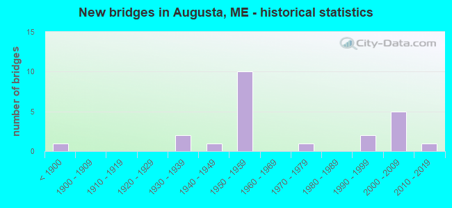
- New bridges - historical statistics
- 1Before 1900
- 21930-1939
- 11940-1949
- 101950-1959
- 11970-1979
- 21990-1999
- 52000-2009
- 12010-2019
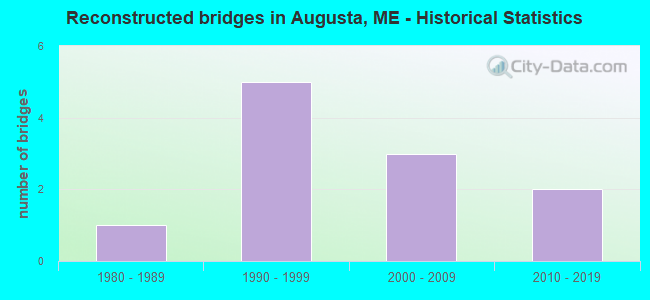
- Reconstructed bridges - Historical Statistics
- 11980-1989
- 51990-1999
- 32000-2009
- 22010-2019
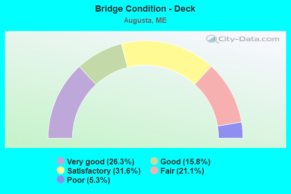
- Bridge Condition - Deck
- 26.3%Very good
- 15.8%Good
- 31.6%Satisfactory
- 21.1%Fair
- 5.3%Poor
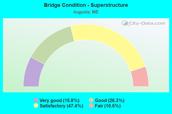
- Bridge Condition - Superstructure
- 15.8%Very good
- 26.3%Good
- 47.4%Satisfactory
- 10.5%Fair
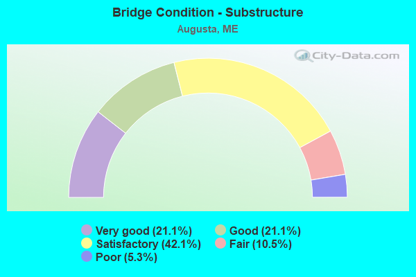
- Bridge Condition - Substructure
- 21.1%Very good
- 21.1%Good
- 42.1%Satisfactory
- 10.5%Fair
- 5.3%Poor
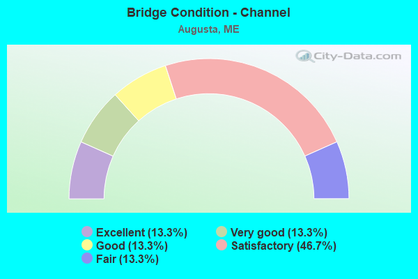
- Bridge Condition - Channel
- 13.3%Excellent
- 13.3%Very good
- 13.3%Good
- 46.7%Satisfactory
- 13.3%Fair
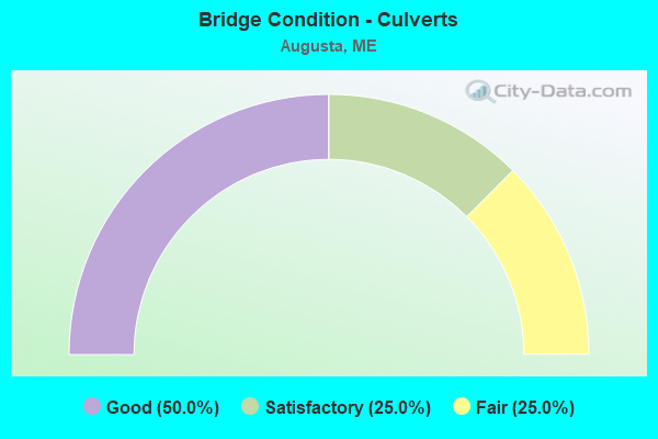
- Bridge Condition - Culverts
- 50.0%Good
- 25.0%Satisfactory
- 25.0%Fair
Find on map >> Show street view
Location: 0.5 MI NE RT 201,100 (Lat: 41.001228, Lng: -100.835261), Route carried "under" structure: County highway 81500, Year Built: 1010, Year Reconstructed: 2010, Status: Open, Structure Length: 0.73m (2.40ft), Average Daily Traffic: 2,000 (year 0015), Truck Traffic: 5%, Average Future Daily Traffic: 254 (year 2036), Design Load: HS 25 or greater, Features Intersected: 02100RIGGS BROOK, Facility Carried by Structure: BLAIR ROAD
Lanes on structure: 91, Lanes under structure: 96, Toll: Toll bridge, Owner: Indian Tribal Government, Maintenance Responsibility: State Highway Agency, Approaching Roadway Width: 201.60m (661.42ft), Skew: 90 degrees, Material/Design: Steel, Design/Construction: Stringer/Multi-beam, Number Of Spans In Main Unit: 1, Length of Maximum Span: 6.7m (22.0ft), Curb-To-Curb Width: 6.7m (22.0ft), Out-to-Out Width: 6.7m (22.0ft)
Condition: Deck: Good, Superstructure: Good, Substructure: Good, Channel: Very good, Operating Rating: 97.2 metric tons, Method Used To Determine Operating Rating: Load and Resistance Factor Rating (LRFR) rating reported by rating factor(RF) method using HL-93 loadings, Inventory Rating: 59.9 metric tons, Method Used To Determine Inventory Rating: Load and Resistance Factor Rating (LRFR) rating reported by rating factor(RF) method using HL-93 loadings, Structural Evaluation: Better than present minimum criteria, Deck Geometry: Meets minimum limits, Waterway Adequacy: Better than present minimum criteria, Approach Roadway Alignment: Meets minimum limits, Designated Inspection Frequency: Every 24 months, Inspection Date: November 2020, Deck Structure Type: Corrugated Steel, Wearing Surface/Protective System: Wearing Surface: Bituminous
Find on map >> Show street view
Structure Number: 1465, Location: MILE 105.8 ON I-95 S B (Lat: 44.346211, Lng: -69.794611), Route carried "on" structure: State highway 95, Year Built: 1959, Year Reconstructed: 1995, Status: Open, Structure Length: 4.29m (14.07ft), Average Daily Traffic: 13,970 (year 2016), Truck Traffic: 5%, Average Future Daily Traffic: 19,558 (year 2036), Design Load: HS 20+Mod, Features Intersected: ROUTESS 8,11,&27
Minimum Vertical Clearance: 30+ m (98+ ft), Kilometerpoint: 309.833, Lanes on structure: 2, Lanes under structure: 4, Base Highway Network: Yes, Owner: State Highway Agency, Approaching Roadway Width: 11.6m (38.1ft), Skew: 1 degrees, Material/Design: Steel, Design/Construction: Stringer/Multi-beam, Number Of Spans In Main Unit: 3, Length of Maximum Span: 17.1m (56.1ft), Curb or Sidewalk Widths: Left: 0.2m (0.7ft), Right: 0.2m (0.7ft), Curb-To-Curb Width: 12.2m (40.0ft), Out-to-Out Width: 13.3m (43.6ft)
Condition: Deck: Fair, Superstructure: Fair, Substructure: Fair, Operating Rating: 66.7 metric tons, Method Used To Determine Operating Rating: Load and Resistance Factor Rating (LRFR) rating reported by rating factor(RF) method using HL-93 loadings, Inventory Rating: 51.5 metric tons, Method Used To Determine Inventory Rating: Load and Resistance Factor Rating (LRFR) rating reported by rating factor(RF) method using HL-93 loadings, Structural Evaluation: Somewhat better than minimum adequacy, Deck Geometry: Better than present minimum criteria, Underclear: High priority of corrective action, Approach Roadway Alignment: Equal to present desirable criteria, Designated Inspection Frequency: Every 24 months, Inspection Date: October 2021, Deck Structure Type: Concrete Cast-file-Place, Wearing Surface/Protective System: Wearing Surface: Bituminous, Membrane: Preformed Fabric
Find on map >> Show street view
Structure Number: 1466, Location: 1.5 MI N US #202 (Lat: 44.338069, Lng: -69.807611), Route carried "on" structure: State highway 95, Year Built: 1959, Year Reconstructed: 1995, Status: Open, Structure Length: 12.65m (41.50ft), Average Daily Traffic: 18,790 (year 2016), Truck Traffic: 10%, Average Future Daily Traffic: 26,306 (year 2036), Design Load: HS 20+Mod, Features Intersected: MARTIN STREAM
Minimum Vertical Clearance: 30+ m (98+ ft), Kilometerpoint: 311.184, Lanes on structure: 2, Lanes under structure: 2, Base Highway Network: Yes, Owner: State Highway Agency, Approaching Roadway Width: 11.6m (38.1ft), Material/Design: Steel continuous, Design/Construction: Stringer/Multi-beam, Number Of Spans In Main Unit: 4, Length of Maximum Span: 33.5m (109.9ft), Curb or Sidewalk Widths: Left: 0.2m (0.7ft), Right: 0.2m (0.7ft), Curb-To-Curb Width: 10.5m (34.4ft), Out-to-Out Width: 11.6m (38.1ft)
Condition: Deck: Satisfactory, Superstructure: Good, Substructure: Satisfactory, Channel: Satisfactory, Operating Rating: 43.1 metric tons, Method Used To Determine Operating Rating: Load and Resistance Factor Rating (LRFR) rating reported by rating factor(RF) method using HL-93 loadings, Inventory Rating: 33.4 metric tons, Method Used To Determine Inventory Rating: Load and Resistance Factor Rating (LRFR) rating reported by rating factor(RF) method using HL-93 loadings, Structural Evaluation: Equal to present minimum criteria, Deck Geometry: Meets minimum limits, Underclear: Somewhat better than minimum adequacy, Waterway Adequacy: Superior to present desirable criteria, Approach Roadway Alignment: Better than present minimum criteria, Designated Inspection Frequency: Every 24 months, Inspection Date: September 2021, Deck Structure Type: Concrete Cast-file-Place, Wearing Surface/Protective System: Wearing Surface: Bituminous, Membrane: Preformed Fabric, Deck Protection: Epoxy Coated Reinforcing
Find on map >> Show street view
Structure Number: 2082, Location: 1.0 MI NW OF JCT RTE 27 (Lat: 44.338811, Lng: -69.808269), Route carried "on" structure: City street , Year Built: 1990, Status: Open, Structure Length: 1.23m (4.04ft), Average Daily Traffic: 2,368 (year 2016), Truck Traffic: 5%, Average Future Daily Traffic: 3,315 (year 2036), Design Load: HS 25 or greater, Features Intersected: BOND BROOK, Facility Carried by Structure: BOND BROOK ROAD
Minimum Vertical Clearance: 30+ m (98+ ft), Kilometerpoint: 1.706, Lanes on structure: 2, Owner: State Highway Agency, Approaching Roadway Width: 9.8m (32.2ft), Material/Design: Steel, Design/Construction: Culvert, Number Of Spans In Main Unit: 2, Length of Maximum Span: 5.5m (18.0ft)
Condition: Channel: Fair, Culverts: Satisfactory, Operating Rating: 62.5 metric tons, Method Used To Determine Operating Rating: Load and Resistance Factor Rating (LRFR) rating reported by rating factor(RF) method using HL-93 loadings, Inventory Rating: 48.3 metric tons, Method Used To Determine Inventory Rating: Load and Resistance Factor Rating (LRFR) rating reported by rating factor(RF) method using HL-93 loadings, Structural Evaluation: Equal to present minimum criteria, Waterway Adequacy: Better than present minimum criteria, Approach Roadway Alignment: Equal to present desirable criteria, Designated Inspection Frequency: Every 24 months, Inspection Date: October 2021
Find on map >> Show street view
Structure Number: 2083, Location: 1.1 MI NW OF JCT RTE 27 (Lat: 44.339389, Lng: -69.808761), Route carried "on" structure: City street , Year Built: 1990, Status: Open, Structure Length: 1.10m (3.61ft), Average Daily Traffic: 2,368 (year 2016), Truck Traffic: 5%, Average Future Daily Traffic: 3,315 (year 2036), Design Load: HS 25 or greater, Features Intersected: BOND BROOK, Facility Carried by Structure: BOND BROOK ROAD
Minimum Vertical Clearance: 30+ m (98+ ft), Kilometerpoint: 1.786, Lanes on structure: 2, Owner: State Highway Agency, Approaching Roadway Width: 9.8m (32.2ft), Skew: 2 degrees, Material/Design: Steel, Design/Construction: Culvert, Number Of Spans In Main Unit: 2, Length of Maximum Span: 4.8m (15.7ft)
Condition: Channel: Satisfactory, Culverts: Fair, Operating Rating: 97.2 metric tons, Method Used To Determine Operating Rating: Load and Resistance Factor Rating (LRFR) rating reported by rating factor(RF) method using HL-93 loadings, Inventory Rating: 76.5 metric tons, Method Used To Determine Inventory Rating: Load and Resistance Factor Rating (LRFR) rating reported by rating factor(RF) method using HL-93 loadings, Structural Evaluation: Somewhat better than minimum adequacy, Waterway Adequacy: Better than present minimum criteria, Approach Roadway Alignment: Equal to present desirable criteria, Designated Inspection Frequency: Every 24 months, Inspection Date: October 2021
Find on map >> Show street view
Structure Number: 2385, Location: 3.7 MI NW OF PRINCETON TL (Lat: 45.265039, Lng: -67.629561), Route carried "on" structure: State highway 1, Year Built: 2007, Status: Open, Structure Length: 0.95m (3.12ft), Average Daily Traffic: 1,641 (year 2016), Truck Traffic: 5%, Average Future Daily Traffic: 2,462 (year 2036), Design Load: HS 25 or greater, Features Intersected: HUNTLEY BROOK
Minimum Vertical Clearance: 30+ m (98+ ft), Kilometerpoint: 543.831, Lanes on structure: 2, Owner: State Highway Agency, Approaching Roadway Width: 9.8m (32.2ft), Skew: 4 degrees, Material/Design: Concrete, Design/Construction: Culvert, Number Of Spans In Main Unit: 1, Length of Maximum Span: 8.6m (28.2ft)
Condition: Channel: Good, Culverts: Good, Operating Rating: 43.7 metric tons, Method Used To Determine Operating Rating: Load and Resistance Factor Rating (LRFR) rating reported by rating factor(RF) method using HL-93 loadings, Inventory Rating: 33.7 metric tons, Method Used To Determine Inventory Rating: Load and Resistance Factor Rating (LRFR) rating reported by rating factor(RF) method using HL-93 loadings, Structural Evaluation: Better than present minimum criteria, Waterway Adequacy: Superior to present desirable criteria, Approach Roadway Alignment: Equal to present desirable criteria, Designated Inspection Frequency: Every 24 months, Inspection Date: May 2021
Find on map >> Show street view
Structure Number: 2719, Location: 3.2 MI SO TOWNLINE (Lat: 44.337981, Lng: -69.757311), Route carried "on" structure: State highway 201, Year Built: 2010, Status: Open, Structure Length: 0.63m (2.07ft), Average Daily Traffic: 9,253 (year 2016), Truck Traffic: 5%, Average Future Daily Traffic: 12,954 (year 2036), Design Load: HL 93, Features Intersected: RIGGS BROOK
Minimum Vertical Clearance: 30+ m (98+ ft), Kilometerpoint: 53.897, Lanes on structure: 2, Base Highway Network: Yes, Owner: State Highway Agency, Approaching Roadway Width: 12.8m (42.0ft), Material/Design: Concrete, Design/Construction: Culvert, Number Of Spans In Main Unit: 1, Length of Maximum Span: 6.3m (20.7ft)
Condition: Channel: Very good, Culverts: Good, Operating Rating: 97.2 metric tons, Method Used To Determine Operating Rating: Assigned ratings based on Load and Resistance Factor Design (LRFD) reported by rating factor (RF) using HL93 loadings, Inventory Rating: 64.8 metric tons, Method Used To Determine Inventory Rating: Assigned ratings based on Load and Resistance Factor Design (LRFD) reported by rating factor (RF) using HL93 loadings, Structural Evaluation: Better than present minimum criteria, Waterway Adequacy: Superior to present desirable criteria, Approach Roadway Alignment: Equal to present desirable criteria, Designated Inspection Frequency: Every 24 months, Inspection Date: November 2020
Find on map >> Show street view
Structure Number: 3077, Location: 0.3 MI N OF BRIDGE STREET (Lat: 44.322850, Lng: -69.775169), Route carried "on" structure: State highway 8, Year Built: 1934, Status: Open, Structure Length: 1.09m (3.58ft), Average Daily Traffic: 13,526 (year 2016), Truck Traffic: 5%, Average Future Daily Traffic: 18,936 (year 2036), Design Load: HS 20, Features Intersected: BOND BROOK
Minimum Vertical Clearance: 30+ m (98+ ft), Kilometerpoint: 1.207, Lanes on structure: 2, Base Highway Network: Yes, Owner: State Highway Agency, Approaching Roadway Width: 9.8m (32.2ft), Material/Design: Steel, Design/Construction: Stringer/Multi-beam, Number Of Spans In Main Unit: 1, Length of Maximum Span: 9.8m (32.2ft), Curb or Sidewalk Widths: Left: 0.2m (0.7ft), Right: 1.8m (5.9ft), Curb-To-Curb Width: 9.9m (32.5ft), Out-to-Out Width: 12.4m (40.7ft)
Condition: Deck: Fair, Superstructure: Satisfactory, Substructure: Satisfactory, Channel: Fair, Operating Rating: 46.3 metric tons, Method Used To Determine Operating Rating: Load and Resistance Factor Rating (LRFR) rating reported by rating factor(RF) method using HL-93 loadings, Inventory Rating: 36.0 metric tons, Method Used To Determine Inventory Rating: Load and Resistance Factor Rating (LRFR) rating reported by rating factor(RF) method using HL-93 loadings, Structural Evaluation: Equal to present minimum criteria, Deck Geometry: Meets minimum limits, Waterway Adequacy: Better than present minimum criteria, Approach Roadway Alignment: Equal to present desirable criteria, Designated Inspection Frequency: Every 24 months, Inspection Date: October 2021, Deck Structure Type: Concrete Cast-file-Place, Wearing Surface/Protective System: Wearing Surface: Latex Concrete
Find on map >> Show street view
Structure Number: 3078, Location: 0.2 MI E OF RTE US 201 (Lat: 44.316769, Lng: -69.772161), Route carried "on" structure: State highway , Year Built: 1972, Status: Open, Structure Length: 12.98m (42.59ft), Average Daily Traffic: 13,867 (year 2016), Truck Traffic: 5%, Average Future Daily Traffic: 19,414 (year 2036), Design Load: HS 20, Features Intersected: KENNEBEC RIVER, Facility Carried by Structure: CONY STREET
Minimum Vertical Clearance: 30+ m (98+ ft), Kilometerpoint: 0.306, Lanes on structure: 3, Base Highway Network: Yes, Owner: State Highway Agency, Approaching Roadway Width: 12.2m (40.0ft), Navigation Control: Yes ( Vertical Clearance: 8.2m (26.9ft), Horizontal Clearance: 25.9m (85.0ft)), Material/Design: Steel continuous, Design/Construction: Stringer/Multi-beam, Number Of Spans In Main Unit: 5, Length of Maximum Span: 28.0m (91.9ft), Curb or Sidewalk Widths: Left: 1.5m (4.9ft), Right: 1.5m (4.9ft), Curb-To-Curb Width: 12.2m (40.0ft), Out-to-Out Width: 15.9m (52.2ft)
Condition: Deck: Satisfactory, Superstructure: Good, Substructure: Satisfactory, Channel: Good, Operating Rating: 26.6 metric tons, Method Used To Determine Operating Rating: Load and Resistance Factor Rating (LRFR) rating reported by rating factor(RF) method using HL-93 loadings, Inventory Rating: 20.1 metric tons, Method Used To Determine Inventory Rating: Load and Resistance Factor Rating (LRFR) rating reported by rating factor(RF) method using HL-93 loadings, Structural Evaluation: Somewhat better than minimum adequacy, Deck Geometry: Meets minimum limits, Waterway Adequacy: Equal to present desirable criteria, Approach Roadway Alignment: Equal to present desirable criteria, Designated Inspection Frequency: Every 24 months, Underwater Inspection Frequency: Every 60 months, Inspection Date: September 2021, Underwater Inspection Date: August 2019, Deck Structure Type: Concrete Cast-file-Place, Wearing Surface/Protective System: Wearing Surface: Latex Concrete
Find on map >> Show street view
Structure Number: 3528, Location: 0.1MI N JCT GROVE ST (Lat: 44.312911, Lng: -69.775181), Route carried "on" structure: County highway , Year Built: 1939, Status: Open, Structure Length: 2.04m (6.69ft), Average Daily Traffic: 5,152 (year 2016), Truck Traffic: 5%, Average Future Daily Traffic: 7,213 (year 2036), Design Load: HS 20, Features Intersected: Old MCRR (now side road), Facility Carried by Structure: WATER STREET
Minimum Vertical Clearance: 30+ m (98+ ft), Kilometerpoint: 0.885, Lanes on structure: 2, Owner: State Highway Agency, Approaching Roadway Width: 12.5m (41.0ft), Skew: 5 degrees, Material/Design: Steel, Design/Construction: Stringer/Multi-beam, Number Of Spans In Main Unit: 1, Length of Maximum Span: 18.6m (61.0ft), Curb or Sidewalk Widths: Left: 2.2m (7.2ft), Right: 2.2m (7.2ft), Curb-To-Curb Width: 12.9m (42.3ft), Out-to-Out Width: 18.7m (61.4ft)
Condition: Deck: Poor, Superstructure: Fair, Substructure: Poor, Operating Rating: 43.7 metric tons, Method Used To Determine Operating Rating: Load and Resistance Factor Rating (LRFR) rating reported by rating factor(RF) method using HL-93 loadings, Inventory Rating: 34.0 metric tons, Method Used To Determine Inventory Rating: Load and Resistance Factor Rating (LRFR) rating reported by rating factor(RF) method using HL-93 loadings, Structural Evaluation: Meets minimum limits, Deck Geometry: Somewhat better than minimum adequacy, Underclear: Somewhat better than minimum adequacy, Approach Roadway Alignment: Equal to present minimum criteria, Designated Inspection Frequency: Every 24 months, Inspection Date: May 2021, Deck Structure Type: Concrete Cast-file-Place, Wearing Surface/Protective System: Wearing Surface: Bituminous
Find on map >> Show street view
Structure Number: 5196, Location: .2 MI W 9 (Lat: 44.312450, Lng: -69.772861), Route carried "on" structure: State highway 201, Year Built: 1949, Year Reconstructed: 2006, Status: Open, Structure Length: 63.95m (209.81ft), Average Daily Traffic: 22,749 (year 2016), Truck Traffic: 5%, Average Future Daily Traffic: 31,849 (year 2036), Design Load: HS 20, Features Intersected: KENNEBEC RIVER + MCRR
Minimum Vertical Clearance: 30+ m (98+ ft), Kilometerpoint: 50.710, Lanes on structure: 2, Lanes under structure: 2, Base Highway Network: Yes, Owner: State Highway Agency, Approaching Roadway Width: 10.4m (34.1ft), Navigation Control: Yes ( Vertical Clearance: 21.3m (69.9ft), Horizontal Clearance: 20.4m (66.9ft)), Material/Design: Steel continuous, Design/Construction: Truss - Deck, Number Of Spans In Main Unit: 5, Number Of Approach Spans: 6, Length of Maximum Span: 106.7m (350.1ft), Curb or Sidewalk Widths: Left: 1.5m (4.9ft), Right: 1.5m (4.9ft), Curb-To-Curb Width: 10.4m (34.1ft), Out-to-Out Width: 14.8m (48.6ft)
Condition: Deck: Good, Superstructure: Satisfactory, Substructure: Satisfactory, Channel: Satisfactory, Operating Rating: 27.2 metric tons, Method Used To Determine Operating Rating: Load and Resistance Factor Rating (LRFR) rating reported by rating factor(RF) method using HL-93 loadings, Inventory Rating: 21.1 metric tons, Method Used To Determine Inventory Rating: Load and Resistance Factor Rating (LRFR) rating reported by rating factor(RF) method using HL-93 loadings, Structural Evaluation: Somewhat better than minimum adequacy, Deck Geometry: Meets minimum limits, Underclear: Meets minimum limits, Waterway Adequacy: Superior to present desirable criteria, Approach Roadway Alignment: Better than present minimum criteria, Designated Inspection Frequency: Every 24 months, Critical Feature Inspection Frequency: Every 24 months, Underwater Inspection Frequency: Every 60 months, Other Special Inspection Frequency: Every 60 months, Inspection Date: December 2021, Critical Feature Inspection Date: October 2021, Underwater Inspection Date: August 2019, Other Special Inspection Date: May 2021, Deck Structure Type: Concrete Cast-file-Place, Wearing Surface/Protective System: Wearing Surface: Bituminous, Membrane: Preformed Fabric
Find on map >> Show street view
Structure Number: 5747, Location: 1.3 MI S JCT 8-11-27 (Lat: 44.339331, Lng: -69.811031), Route carried "on" structure: County highway , Year Built: 1959, Year Reconstructed: 1980, Status: Open, Structure Length: 1.08m (3.54ft), Average Daily Traffic: 7,465 (year 2016), Truck Traffic: 5%, Average Future Daily Traffic: 10,451 (year 2036), Design Load: H 20, Features Intersected: BOND BROOK, Facility Carried by Structure: LEIGHTON RD
Minimum Vertical Clearance: 30+ m (98+ ft), Kilometerpoint: 2.237, Lanes on structure: 2, Owner: State Highway Agency, Approaching Roadway Width: 7.9m (25.9ft), Material/Design: Concrete, Design/Construction: Slab, Number Of Spans In Main Unit: 1, Length of Maximum Span: 9.7m (31.8ft), Curb or Sidewalk Widths: Left: 0.2m (0.7ft), Right: 0.2m (0.7ft), Curb-To-Curb Width: 10.6m (34.8ft), Out-to-Out Width: 11.9m (39.0ft)
Condition: Deck: Satisfactory, Superstructure: Satisfactory, Substructure: Good, Channel: Satisfactory, Operating Rating: 33.7 metric tons, Method Used To Determine Operating Rating: Load and Resistance Factor Rating (LRFR) rating reported by rating factor(RF) method using HL-93 loadings, Inventory Rating: 25.9 metric tons, Method Used To Determine Inventory Rating: Load and Resistance Factor Rating (LRFR) rating reported by rating factor(RF) method using HL-93 loadings, Structural Evaluation: Equal to present minimum criteria, Deck Geometry: Meets minimum limits, Waterway Adequacy: Superior to present desirable criteria, Approach Roadway Alignment: Somewhat better than minimum adequacy, Designated Inspection Frequency: Every 24 months, Inspection Date: March 2021, Deck Structure Type: Concrete Cast-file-Place, Wearing Surface/Protective System: Wearing Surface: Bituminous, Membrane: Other
Find on map >> Show street view
Structure Number: 5787, Location: 1.5 MI N US 202 OVERPASS (Lat: 44.337950, Lng: -69.807469), Route carried "on" structure: State highway 95, Year Built: 1959, Year Reconstructed: 1995, Status: Open, Structure Length: 12.56m (41.21ft), Average Daily Traffic: 18,290 (year 2016), Truck Traffic: 10%, Average Future Daily Traffic: 25,606 (year 2036), Design Load: HS 20+Mod, Features Intersected: BOND BROOK & BOND BK RD
Minimum Vertical Clearance: 30+ m (98+ ft), Kilometerpoint: 176.609, Lanes on structure: 2, Lanes under structure: 2, Base Highway Network: Yes, Owner: State Highway Agency, Approaching Roadway Width: 11.6m (38.1ft), Material/Design: Steel continuous, Design/Construction: Stringer/Multi-beam, Number Of Spans In Main Unit: 4, Length of Maximum Span: 33.5m (109.9ft), Curb or Sidewalk Widths: Left: 0.2m (0.7ft), Right: 0.2m (0.7ft), Curb-To-Curb Width: 10.5m (34.4ft), Out-to-Out Width: 11.6m (38.1ft)
Condition: Deck: Satisfactory, Superstructure: Satisfactory, Substructure: Satisfactory, Channel: Satisfactory, Operating Rating: 43.1 metric tons, Method Used To Determine Operating Rating: Load and Resistance Factor Rating (LRFR) rating reported by rating factor(RF) method using HL-93 loadings, Inventory Rating: 33.4 metric tons, Method Used To Determine Inventory Rating: Load and Resistance Factor Rating (LRFR) rating reported by rating factor(RF) method using HL-93 loadings, Structural Evaluation: Equal to present minimum criteria, Deck Geometry: Meets minimum limits, Underclear: Somewhat better than minimum adequacy, Waterway Adequacy: Superior to present desirable criteria, Approach Roadway Alignment: Better than present minimum criteria, Designated Inspection Frequency: Every 24 months, Inspection Date: April 2021, Deck Structure Type: Concrete Cast-file-Place, Wearing Surface/Protective System: Wearing Surface: Bituminous, Membrane: Preformed Fabric, Deck Protection: Epoxy Coated Reinforcing
Find on map >> Show street view
Structure Number: 5788, Location: OVER I95 0.2 MI N US 202 (Lat: 44.320131, Lng: -69.813431), Route carried "on" structure: County highway , Year Built: 1958, Year Reconstructed: 1995, Status: Open, Structure Length: 7.42m (24.34ft), Average Daily Traffic: 3,330 (year 2016), Truck Traffic: 5%, Average Future Daily Traffic: 4,662 (year 2036), Design Load: H 20, Features Intersected: INTERSTATE 95, Facility Carried by Structure: OLD WINTHROP ROAD
Minimum Vertical Clearance: 30+ m (98+ ft), Kilometerpoint: 1.127, Lanes on structure: 2, Lanes under structure: 4, Owner: State Highway Agency, Approaching Roadway Width: 8.5m (27.9ft), Skew: 3 degrees, Material/Design: Steel continuous, Design/Construction: Stringer/Multi-beam, Number Of Spans In Main Unit: 4, Length of Maximum Span: 20.1m (65.9ft), Curb or Sidewalk Widths: Left: 0.1m (0.3ft), Right: 0.1m (0.3ft), Curb-To-Curb Width: 8.4m (27.6ft), Out-to-Out Width: 9.4m (30.8ft)
Condition: Deck: Satisfactory, Superstructure: Satisfactory, Substructure: Good, Operating Rating: 34.7 metric tons, Method Used To Determine Operating Rating: Load and Resistance Factor Rating (LRFR) rating reported by rating factor(RF) method using HL-93 loadings, Inventory Rating: 26.6 metric tons, Method Used To Determine Inventory Rating: Load and Resistance Factor Rating (LRFR) rating reported by rating factor(RF) method using HL-93 loadings, Structural Evaluation: Equal to present minimum criteria, Deck Geometry: High priority of corrective action, Underclear: High priority of corrective action, Approach Roadway Alignment: Equal to present desirable criteria, Designated Inspection Frequency: Every 24 months, Inspection Date: May 2021, Deck Structure Type: Concrete Cast-file-Place, Wearing Surface/Protective System: Wearing Surface: Bituminous, Membrane: Preformed Fabric
Find on map >> Show street view
Structure Number: 5793, Location: I-95 INTERCHANGE 112 (Lat: 44.346019, Lng: -69.794550), Route carried "on" structure: State highway 95, Year Built: 1959, Year Reconstructed: 2011, Status: Open, Structure Length: 4.22m (13.85ft), Average Daily Traffic: 15,720 (year 2016), Truck Traffic: 10%, Average Future Daily Traffic: 22,008 (year 2036), Design Load: HS 20+Mod, Features Intersected: ROUTES 8,11,&27
Minimum Vertical Clearance: 30+ m (98+ ft), Kilometerpoint: 177.977, Lanes on structure: 2, Lanes under structure: 4, Base Highway Network: Yes, Owner: State Highway Agency, Approaching Roadway Width: 12.2m (40.0ft), Skew: 1 degrees, Material/Design: Steel, Design/Construction: Stringer/Multi-beam, Number Of Spans In Main Unit: 3, Length of Maximum Span: 17.1m (56.1ft), Curb or Sidewalk Widths: Left: 0.1m (0.3ft), Right: 0.1m (0.3ft), Curb-To-Curb Width: 12.2m (40.0ft), Out-to-Out Width: 12.9m (42.3ft)
Condition: Deck: Very good, Superstructure: Satisfactory, Substructure: Satisfactory, Operating Rating: 73.5 metric tons, Method Used To Determine Operating Rating: Load and Resistance Factor Rating (LRFR) rating reported by rating factor(RF) method using HL-93 loadings, Inventory Rating: 56.7 metric tons, Method Used To Determine Inventory Rating: Load and Resistance Factor Rating (LRFR) rating reported by rating factor(RF) method using HL-93 loadings, Structural Evaluation: Equal to present minimum criteria, Deck Geometry: Better than present minimum criteria, Underclear: High priority of corrective action, Approach Roadway Alignment: Equal to present desirable criteria, Designated Inspection Frequency: Every 24 months, Inspection Date: October 2021, Deck Structure Type: Concrete Cast-file-Place, Wearing Surface/Protective System: Wearing Surface: Integral Concrete
Find on map >> Show street view
Structure Number: 5806, Location: 1.0 MI N OF JCT RTE 104 (Lat: 44.351469, Lng: -69.784539), Route carried "on" structure: County highway , Year Built: 1959, Year Reconstructed: 1995, Status: Open, Structure Length: 9.27m (30.41ft), Average Daily Traffic: 2,652 (year 2016), Truck Traffic: 5%, Average Future Daily Traffic: 3,713 (year 2036), Design Load: H 20, Features Intersected: INTERSTATE 95, Facility Carried by Structure: OLD BELGRADE ROAD
Minimum Vertical Clearance: 30+ m (98+ ft), Kilometerpoint: 0.000, Lanes on structure: 2, Lanes under structure: 4, Owner: State Highway Agency, Approaching Roadway Width: 8.8m (28.9ft), Skew: 3 degrees, Material/Design: Steel, Design/Construction: Stringer/Multi-beam, Number Of Spans In Main Unit: 5, Length of Maximum Span: 20.1m (65.9ft), Curb or Sidewalk Widths: Left: 0.2m (0.7ft), Right: 0.2m (0.7ft), Curb-To-Curb Width: 8.3m (27.2ft), Out-to-Out Width: 9.4m (30.8ft)
Condition: Deck: Fair, Superstructure: Satisfactory, Substructure: Satisfactory, Operating Rating: 54.1 metric tons, Method Used To Determine Operating Rating: Load and Resistance Factor Rating (LRFR) rating reported by rating factor(RF) method using HL-93 loadings, Inventory Rating: 41.8 metric tons, Method Used To Determine Inventory Rating: Load and Resistance Factor Rating (LRFR) rating reported by rating factor(RF) method using HL-93 loadings, Structural Evaluation: Equal to present minimum criteria, Deck Geometry: High priority of corrective action, Underclear: High priority of corrective action, Approach Roadway Alignment: Equal to present desirable criteria, Designated Inspection Frequency: Every 24 months, Inspection Date: April 2021, Deck Structure Type: Concrete Cast-file-Place, Wearing Surface/Protective System: Wearing Surface: Bituminous, Membrane: Preformed Fabric
Find on map >> Show street view
Structure Number: 5807, Location: OVER I-95 MILE 103.1 NB (Lat: 44.312950, Lng: -69.809850), Route carried "on" structure: Ramp State highway , Year Built: 1959, Year Reconstructed: 2018, Status: Open, Structure Length: 6.31m (20.70ft), Average Daily Traffic: 4,660 (year 2016), Truck Traffic: 10%, Average Future Daily Traffic: 6,524 (year 2036), Design Load: HS 25 or greater, Features Intersected: INTERSTATE 95, Facility Carried by Structure: RAMP TO & FROM I95
Minimum Vertical Clearance: 30+ m (98+ ft), Kilometerpoint: 0.145, Lanes on structure: 2, Lanes under structure: 5, Owner: State Highway Agency, Approaching Roadway Width: 12.5m (41.0ft), Material/Design: Steel continuous, Design/Construction: Stringer/Multi-beam, Number Of Spans In Main Unit: 4, Length of Maximum Span: 17.1m (56.1ft), Curb or Sidewalk Widths: Left: 0.2m (0.7ft), Right: 0.2m (0.7ft), Curb-To-Curb Width: 9.6m (31.5ft), Out-to-Out Width: 10.4m (34.1ft)
Condition: Deck: Good, Superstructure: Very good, Substructure: Good, Channel: Satisfactory, Operating Rating: 55.4 metric tons, Method Used To Determine Operating Rating: Load and Resistance Factor Rating (LRFR) rating reported by rating factor(RF) method using HL-93 loadings, Inventory Rating: 42.8 metric tons, Method Used To Determine Inventory Rating: Load and Resistance Factor Rating (LRFR) rating reported by rating factor(RF) method using HL-93 loadings, Structural Evaluation: Better than present minimum criteria, Deck Geometry: Somewhat better than minimum adequacy, Underclear: High priority of corrective action, Approach Roadway Alignment: Equal to present minimum criteria, Designated Inspection Frequency: Every 24 months, Inspection Date: September 2021, Deck Structure Type: Concrete Cast-file-Place, Wearing Surface/Protective System: Wearing Surface: Monolithic Concrete, Deck Protection: Other
Find on map >> Show street view
Structure Number: 5808, Location: 1.6 MI W OF JCT RTE 201 (Lat: 44.316439, Lng: -69.811550), Route carried "on" structure: State highway 202, Year Built: 1955, Status: Open, Structure Length: 8.02m (26.31ft), Average Daily Traffic: 16,934 (year 2016), Truck Traffic: 5%, Average Future Daily Traffic: 23,708 (year 2036), Design Load: HS 20, Features Intersected: INTERSTATE 95
Minimum Vertical Clearance: 30+ m (98+ ft), Kilometerpoint: 163.847, Lanes on structure: 5, Lanes under structure: 5, Base Highway Network: Yes, Owner: State Highway Agency, Approaching Roadway Width: 24.4m (80.1ft), Skew: 22 degrees, Material/Design: Steel continuous, Design/Construction: Stringer/Multi-beam, Number Of Spans In Main Unit: 4, Length of Maximum Span: 24.4m (80.1ft), Curb or Sidewalk Widths: Left: 1.2m (3.9ft), Right: 1.2m (3.9ft), Curb-To-Curb Width: 24.4m (80.1ft), Out-to-Out Width: 27.6m (90.6ft)
Condition: Deck: Fair, Superstructure: Satisfactory, Substructure: Fair, Channel: Satisfactory, Operating Rating: 41.5 metric tons, Method Used To Determine Operating Rating: Load and Resistance Factor Rating (LRFR) rating reported by rating factor(RF) method using HL-93 loadings, Inventory Rating: 36.0 metric tons, Method Used To Determine Inventory Rating: Load and Resistance Factor Rating (LRFR) rating reported by rating factor(RF) method using HL-93 loadings, Structural Evaluation: Somewhat better than minimum adequacy, Deck Geometry: Superior to present desirable criteria, Underclear: High priority of corrective action, Approach Roadway Alignment: Equal to present desirable criteria, Designated Inspection Frequency: Every 24 months, Inspection Date: April 2021, Deck Structure Type: Concrete Cast-file-Place, Wearing Surface/Protective System: Wearing Surface: Monolithic Concrete
Find on map >> Show street view
Structure Number: 5809, Location: 0.1 MI E OF I 95 OVERPASS (Lat: 44.316231, Lng: -69.808631), Route carried "on" structure: Ramp State highway , Year Built: 1950, Year Reconstructed: 2000, Status: Open, Structure Length: 5.66m (18.57ft), Average Daily Traffic: 4,820 (year 2016), Truck Traffic: 10%, Average Future Daily Traffic: 6,748 (year 2036), Design Load: HS 20, Features Intersected: ROUTES 11 17 100 202, Facility Carried by Structure: RAMP TO & FROM I 9
Minimum Vertical Clearance: 30+ m (98+ ft), Kilometerpoint: 0.612, Lanes on structure: 2, Lanes under structure: 5, Owner: State Highway Agency, Approaching Roadway Width: 13.7m (44.9ft), Skew: 1 degrees, Material/Design: Steel continuous, Design/Construction: Stringer/Multi-beam, Number Of Spans In Main Unit: 3, Length of Maximum Span: 27.1m (88.9ft), Curb or Sidewalk Widths: Left: 0.2m (0.7ft), Right: 0.2m (0.7ft), Curb-To-Curb Width: 10.5m (34.4ft), Out-to-Out Width: 11.3m (37.1ft)
Condition: Deck: Satisfactory, Superstructure: Satisfactory, Substructure: Satisfactory, Operating Rating: 51.5 metric tons, Method Used To Determine Operating Rating: Load and Resistance Factor Rating (LRFR) rating reported by rating factor(RF) method using HL-93 loadings, Inventory Rating: 39.9 metric tons, Method Used To Determine Inventory Rating: Load and Resistance Factor Rating (LRFR) rating reported by rating factor(RF) method using HL-93 loadings, Structural Evaluation: Equal to present minimum criteria, Deck Geometry: Better than present minimum criteria, Underclear: High priority of corrective action, Approach Roadway Alignment: Equal to present minimum criteria, Designated Inspection Frequency: Every 24 months, Inspection Date: June 2021, Deck Structure Type: Concrete Cast-file-Place, Wearing Surface/Protective System: Wearing Surface: Bituminous, Membrane: Preformed Fabric, Deck Protection: Epoxy Coated Reinforcing
Find on map >> Show street view
Structure Number: 64, Location: .2 Mi.W RTE 201/100 (Lat: 44.335361, Lng: -69.764581), Route carried "on" structure: State highway 3, Year Built: 2005, Status: Open, Structure Length: 33.78m (110.83ft), Average Daily Traffic: 14,820 (year 2016), Truck Traffic: 5%, Average Future Daily Traffic: 20,748 (year 2036), Design Load: HS 25 or greater, Features Intersected: Kennebec River
Minimum Vertical Clearance: 30+ m (98+ ft), Kilometerpoint: 4.587, Lanes on structure: 4, Base Highway Network: Yes, Owner: State Highway Agency, Approaching Roadway Width: 19.2m (63.0ft), Skew: 2 degrees, Material/Design: Steel continuous, Design/Construction: Stringer/Multi-beam, Number Of Spans In Main Unit: 5, Length of Maximum Span: 73.0m (239.5ft), Curb-To-Curb Width: 19.2m (63.0ft), Out-to-Out Width: 20.2m (66.3ft)
Condition: Deck: Very good, Superstructure: Very good, Substructure: Very good, Channel: Excellent, Operating Rating: 63.8 metric tons, Method Used To Determine Operating Rating: Load and Resistance Factor Rating (LRFR) rating reported by rating factor(RF) method using HL-93 loadings, Inventory Rating: 36.3 metric tons, Method Used To Determine Inventory Rating: Load and Resistance Factor Rating (LRFR) rating reported by rating factor(RF) method using HL-93 loadings, Structural Evaluation: Equal to present desirable criteria, Deck Geometry: Equal to present minimum criteria, Waterway Adequacy: Superior to present desirable criteria, Approach Roadway Alignment: Equal to present desirable criteria, Designated Inspection Frequency: Every 24 months, Underwater Inspection Frequency: Every 60 months, Inspection Date: September 2021, Underwater Inspection Date: October 2020, Deck Structure Type: Concrete Cast-file-Place, Wearing Surface/Protective System: Wearing Surface: Bituminous, Membrane: Preformed Fabric
Find on map >> Show street view
Structure Number: 6406, Location: INTERCHANGE 113 (Lat: 44.354269, Lng: -69.781631), Route carried "on" structure: State highway 3, Year Built: 2005, Status: Open, Structure Length: 5.06m (16.60ft), Average Daily Traffic: 4,867 (year 2016), Truck Traffic: 5%, Average Future Daily Traffic: 6,814 (year 2036), Design Load: HS 25 or greater, Features Intersected: I-95 NORTHBOUND
Minimum Vertical Clearance: 30+ m (98+ ft), Kilometerpoint: 1.835, Lanes on structure: 2, Lanes under structure: 2, Base Highway Network: Yes, Owner: State Highway Agency, Approaching Roadway Width: 14.0m (45.9ft), Skew: 35 degrees, Material/Design: Steel, Design/Construction: Stringer/Multi-beam, Number Of Spans In Main Unit: 1, Length of Maximum Span: 50.6m (166.0ft), Curb-To-Curb Width: 14.0m (45.9ft), Out-to-Out Width: 14.8m (48.6ft)
Condition: Deck: Very good, Superstructure: Good, Substructure: Very good, Operating Rating: 64.5 metric tons, Method Used To Determine Operating Rating: Load and Resistance Factor Rating (LRFR) rating reported by rating factor(RF) method using HL-93 loadings, Inventory Rating: 49.6 metric tons, Method Used To Determine Inventory Rating: Load and Resistance Factor Rating (LRFR) rating reported by rating factor(RF) method using HL-93 loadings, Structural Evaluation: Better than present minimum criteria, Deck Geometry: Superior to present desirable criteria, Underclear: Equal to present minimum criteria, Approach Roadway Alignment: Superior to present desirable criteria, Designated Inspection Frequency: Every 24 months, Inspection Date: September 2020, Deck Structure Type: Concrete Cast-file-Place, Wearing Surface/Protective System: Wearing Surface: Bituminous, Membrane: Preformed Fabric
Find on map >> Show street view
Structure Number: 6407, Location: INTERCHANGE 113 (Lat: 44.354869, Lng: -69.782219), Route carried "on" structure: State highway 3, Year Built: 2005, Status: Open, Structure Length: 4.53m (14.86ft), Average Daily Traffic: 4,867 (year 2016), Truck Traffic: 5%, Average Future Daily Traffic: 6,814 (year 2036), Design Load: HS 25 or greater, Features Intersected: I-95 SOUTHBOUND
Minimum Vertical Clearance: 30+ m (98+ ft), Kilometerpoint: 1.835, Lanes on structure: 2, Lanes under structure: 2, Base Highway Network: Yes, Owner: State Highway Agency, Approaching Roadway Width: 14.0m (45.9ft), Skew: 5 degrees, Material/Design: Steel, Design/Construction: Stringer/Multi-beam, Number Of Spans In Main Unit: 1, Length of Maximum Span: 44.4m (145.7ft), Curb-To-Curb Width: 9.1m (29.9ft), Out-to-Out Width: 14.8m (48.6ft)
Condition: Deck: Very good, Superstructure: Good, Substructure: Very good, Channel: Excellent, Operating Rating: 51.2 metric tons, Method Used To Determine Operating Rating: Load and Resistance Factor Rating (LRFR) rating reported by rating factor(RF) method using HL-93 loadings, Inventory Rating: 39.5 metric tons, Method Used To Determine Inventory Rating: Load and Resistance Factor Rating (LRFR) rating reported by rating factor(RF) method using HL-93 loadings, Structural Evaluation: Better than present minimum criteria, Deck Geometry: Meets minimum limits, Underclear: Equal to present minimum criteria, Approach Roadway Alignment: Equal to present desirable criteria, Designated Inspection Frequency: Every 24 months, Inspection Date: September 2020, Deck Structure Type: Concrete Cast-file-Place, Wearing Surface/Protective System: Wearing Surface: Bituminous, Membrane: Preformed Fabric
Find on map >> Show street view
Structure Number: 6408, Location: 0.3 MI E I95 INTERCH 113 (Lat: 44.351731, Lng: -69.778089), Route carried "on" structure: State highway 3, Year Built: 2005, Status: Open, Structure Length: 3.63m (11.91ft), Average Daily Traffic: 17,211 (year 2016), Truck Traffic: 5%, Average Future Daily Traffic: 24,095 (year 2036), Design Load: HS 25 or greater, Features Intersected: EIGHT ROD ROAD
Minimum Vertical Clearance: 30+ m (98+ ft), Kilometerpoint: 2.688, Lanes on structure: 4, Lanes under structure: 2, Base Highway Network: Yes, Owner: State Highway Agency, Approaching Roadway Width: 19.2m (63.0ft), Skew: 1 degrees, Material/Design: Prestressed concrete, Design/Construction: Stringer/Multi-beam, Number Of Spans In Main Unit: 1, Length of Maximum Span: 35.4m (116.1ft), Curb-To-Curb Width: 19.2m (63.0ft), Out-to-Out Width: 20.2m (66.3ft)
Condition: Deck: Very good, Superstructure: Very good, Substructure: Very good, Operating Rating: 60.6 metric tons, Method Used To Determine Operating Rating: Load and Resistance Factor Rating (LRFR) rating reported by rating factor(RF) method using HL-93 loadings, Inventory Rating: 46.7 metric tons, Method Used To Determine Inventory Rating: Load and Resistance Factor Rating (LRFR) rating reported by rating factor(RF) method using HL-93 loadings, Structural Evaluation: Equal to present desirable criteria, Deck Geometry: Equal to present minimum criteria, Underclear: Better than present minimum criteria, Approach Roadway Alignment: Superior to present desirable criteria, Designated Inspection Frequency: Every 24 months, Inspection Date: September 2020, Deck Structure Type: Concrete Cast-file-Place, Wearing Surface/Protective System: Wearing Surface: Bituminous, Membrane: Preformed Fabric
Find on map >> Show street view
Location: JCT OF RTE'S 1& 3 (Lat: 44.423653, Lng: -69.806822), Route carried "on" structure: Ramp State highway 82310, Structure Length: 0. m, Average Daily Traffic: 10,635 (year 2014), Truck Traffic: 5%, Features Intersected: US ROUE 1, Facility Carried by Structure: ROUTE 3
Minimum Vertical Clearance: 4.80m (15.75ft), Kilometerpoint: 74.207, Lanes on structure: 4, Length of Maximum Span: 0.0m
Find on map >> Show street view
Location: 2.2 MI. NE TOWNLINE (Lat: 44.299475, Lng: -69.716731), Route carried "under" structure: Alternate City street 12310, Structure Length: 0. m, Average Daily Traffic: 10,416 (year 2014), Truck Traffic: 9%, Features Intersected: RTE 11, 100, US202, Facility Carried by Structure: MCRR & RAMPS TO 41
Minimum Vertical Clearance: 4.69m (15.39ft), Kilometerpoint: 149.476, Lanes on structure: 2, Length of Maximum Span: 0.0m
Find on map >> Show street view
Location: INTERCHANGE 113 (Lat: 44.354258, Lng: -69.781644), Route carried "under" structure: County highway 62310, Structure Length: 0. m, Average Daily Traffic: 12,597 (year 2014), Truck Traffic: 11%, Features Intersected: ROUTE 3, Facility Carried by Structure: I-95 NORTHBOUND
Minimum Vertical Clearance: 5.64m (18.50ft), Kilometerpoint: 179.345, Lanes on structure: 2, Length of Maximum Span: 0.0m
Find on map >> Show street view
Location: INTERCHANGE 113 (Lat: 44.354839, Lng: -69.782236), Route carried "under" structure: County highway 72310, Structure Length: 0. m, Average Daily Traffic: 4,570 (year 2014), Truck Traffic: 9%, Features Intersected: ROUTE 3, Facility Carried by Structure: I-95 SOUTHBOUND
Minimum Vertical Clearance: 5.64m (18.50ft), Kilometerpoint: 1.835, Lanes on structure: 2, Length of Maximum Span: 0.0m
Find on map >> Show street view
Location: 0.3 MI E I95 INTERCH 113 (Lat: 44.351519, Lng: -69.777781), Route carried "under" structure: County highway 82500, Structure Length: 0. m, Average Daily Traffic: 460 (year 2014), Truck Traffic: 5%, Features Intersected: ROUTE 3, Facility Carried by Structure: EIGHT ROD ROAD
Minimum Vertical Clearance: 4.80m (15.75ft), Kilometerpoint: 3.766, Lanes on structure: 2, Length of Maximum Span: 0.0m