Bridge Statistics for Augusta, Missouri (MO)
Condition, Traffic, Stress, Structural Evaluation, Project Costs
- National Bridge Inventory (NBI) Statistics
- 11Number of bridges
- 89ft / 26.9mTotal length
- 3,333Total average daily traffic
- 420Total average daily truck traffic
- 6,121Total future (year 2039) average daily traffic
- National Bridge Inventory (NBI) Registered Bridges for Augusta
- No street view available for this location
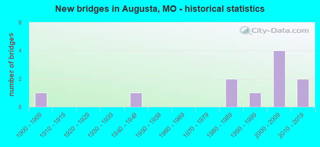
- New bridges - historical statistics
- 11900-1909
- 11940-1949
- 21980-1989
- 11990-1999
- 42000-2009
- 22010-2019


- Bridge Condition - Deck
- 16.7%Very good
- 66.7%Good
- 16.7%Fair

- Bridge Condition - Superstructure
- 33.3%Very good
- 16.7%Good
- 16.7%Satisfactory
- 33.3%Fair

- Bridge Condition - Substructure
- 33.3%Very good
- 50.0%Satisfactory
- 16.7%Fair

- Bridge Condition - Channel
- 9.1%Good
- 45.5%Satisfactory
- 36.4%Fair
- 9.1%Poor

- Bridge Condition - Culverts
- 20.0%Very good
- 60.0%Good
- 20.0%Satisfactory
Find on map >> Show street view
Structure Number: 20506, Location: S 16 T 52 N R 4 W (Lat: 39.280194, Lng: -91.356028), Route carried "on" structure: County highway 263, Year Built: 1980, Status: Open, Structure Length: 1.16m (3.81ft), Average Daily Traffic: 35 (year 2021), Truck Traffic: 10%, Average Future Daily Traffic: 44 (year 2041), Features Intersected: BR OF INDIAN CR, Facility Carried by Structure: COUNTY RD 453
Minimum Vertical Clearance: 30+ m (98+ ft), Kilometerpoint: 0.322, Lanes on structure: 2, Owner: County Highway Agency, Approaching Roadway Width: 6.7m (22.0ft), Material/Design: Prestressed concrete, Design/Construction: Tee Beam, Number Of Spans In Main Unit: 1, Length of Maximum Span: 11.0m (36.1ft), Curb-To-Curb Width: 7.3m (24.0ft), Out-to-Out Width: 7.3m (24.0ft)
Condition: Deck: Good, Superstructure: Fair, Substructure: Satisfactory, Channel: Satisfactory, Operating Rating: 32.4 metric tons, Method Used To Determine Operating Rating: Allowable Stress (AS), Inventory Rating: 18.0 metric tons, Method Used To Determine Inventory Rating: Allowable Stress (AS), Structural Evaluation: Somewhat better than minimum adequacy, Deck Geometry: Equal to present minimum criteria, Waterway Adequacy: Equal to present minimum criteria, Approach Roadway Alignment: Equal to present desirable criteria, Designated Inspection Frequency: Every 24 months, Inspection Date: July 2020, Deck Structure Type: Concrete Cast-file-Place
Find on map >> Show street view
Structure Number: 20553, Location: S 31 T 64 N R 7 W (Lat: 40.307306, Lng: -91.721056), Route carried "on" structure: County highway 264, Year Built: 1993, Status: Open, Structure Length: 7.92m (25.98ft), Average Daily Traffic: 50 (year 2019), Truck Traffic: 10%, Average Future Daily Traffic: 63 (year 2039), Design Load: HS 20, Features Intersected: WYACONDA RVR
Minimum Vertical Clearance: 30+ m (98+ ft), Kilometerpoint: 1.931, Lanes on structure: 2, Owner: County Highway Agency, Approaching Roadway Width: 7.3m (24.0ft), Skew: 1 degrees, Material/Design: Prestressed concrete continuous, Design/Construction: Stringer/Multi-beam, Number Of Spans In Main Unit: 3, Length of Maximum Span: 27.4m (89.9ft), Curb-To-Curb Width: 7.4m (24.3ft), Out-to-Out Width: 7.5m (24.6ft)
Condition: Deck: Very good, Superstructure: Very good, Substructure: Satisfactory, Channel: Satisfactory, Operating Rating: 54.0 metric tons, Method Used To Determine Operating Rating: Allowable Stress (AS), Inventory Rating: 32.4 metric tons, Method Used To Determine Inventory Rating: Allowable Stress (AS), Structural Evaluation: Equal to present minimum criteria, Deck Geometry: Equal to present minimum criteria, Waterway Adequacy: Equal to present minimum criteria, Approach Roadway Alignment: Equal to present minimum criteria, Designated Inspection Frequency: Every 24 months, Inspection Date: July 2021, Deck Structure Type: Concrete Precast Panels
Find on map >> Show street view
Structure Number: 22701, Location: S 10 T 44 N R 1 E (Lat: 38.586944, Lng: -90.896611), Route carried "on" structure: County highway 370, Year Built: 1900, Year Reconstructed: 2007, Status: Open, Structure Length: 1.92m (6.30ft), Average Daily Traffic: 10 (year 2020), Truck Traffic: 5%, Average Future Daily Traffic: 22 (year 2040), Design Load: HS 20, Features Intersected: SEHRT CR, Facility Carried by Structure: NAHM RD
Minimum Vertical Clearance: 30+ m (98+ ft), Kilometerpoint: 0.241, Lanes on structure: 1, Owner: County Highway Agency, Approaching Roadway Width: 4.3m (14.1ft), Material/Design: Steel, Design/Construction: Stringer/Multi-beam, Number Of Spans In Main Unit: 2, Length of Maximum Span: 9.4m (30.8ft), Curb-To-Curb Width: 4.3m (14.1ft), Out-to-Out Width: 5.1m (16.7ft)
Condition: Deck: Good, Superstructure: Fair, Substructure: Fair, Channel: Fair, Operating Rating: 70.2 metric tons, Method Used To Determine Operating Rating: Load Factor (LF), Inventory Rating: 42.3 metric tons, Method Used To Determine Inventory Rating: Load Factor (LF), Structural Evaluation: Somewhat better than minimum adequacy, Deck Geometry: Equal to present minimum criteria, Waterway Adequacy: Better than present minimum criteria, Approach Roadway Alignment: Equal to present minimum criteria, Designated Inspection Frequency: Every 24 months, Inspection Date: Febuary 2022, Deck Structure Type: Concrete Cast-file-Place
Find on map >> Show street view
Structure Number: 22925, Location: S 26 T 45 N R 1 E (Lat: 38.626381, Lng: -90.871119), Route carried "on" structure: County highway 381, Year Built: 1989, Status: Open, Structure Length: 1.92m (6.30ft), Average Daily Traffic: 284 (year 2020), Truck Traffic: 15%, Average Future Daily Traffic: 625 (year 2040), Features Intersected: TRIB OF FEMME OSAG, Facility Carried by Structure: SCHLUERSBURG RD
Minimum Vertical Clearance: 30+ m (98+ ft), Kilometerpoint: 3.138, Lanes on structure: 2, Owner: County Highway Agency, Approaching Roadway Width: 7.9m (25.9ft), Material/Design: Steel, Design/Construction: Stringer/Multi-beam, Number Of Spans In Main Unit: 1, Length of Maximum Span: 18.3m (60.0ft), Curb-To-Curb Width: 7.9m (25.9ft), Out-to-Out Width: 9.2m (30.2ft)
Condition: Deck: Fair, Superstructure: Satisfactory, Substructure: Satisfactory, Channel: Fair, Operating Rating: 75.6 metric tons, Method Used To Determine Operating Rating: Load Factor (LF), Inventory Rating: 45.0 metric tons, Method Used To Determine Inventory Rating: Load Factor (LF), Structural Evaluation: Equal to present minimum criteria, Deck Geometry: Somewhat better than minimum adequacy, Waterway Adequacy: Equal to present desirable criteria, Approach Roadway Alignment: Equal to present minimum criteria, Designated Inspection Frequency: Every 24 months, Inspection Date: Febuary 2022, Deck Structure Type: Concrete Cast-file-Place, Wearing Surface/Protective System: Wearing Surface: Bituminous
Find on map >> Show street view
Structure Number: 31823, Location: S 10 T 44 N R 1 E (Lat: 38.580700, Lng: -90.896414), Route carried "on" structure: State highway 94, Year Built: 2007, Status: Open, Structure Length: 4.82m (15.81ft), Average Daily Traffic: 1,714 (year 2021), Truck Traffic: 10%, Average Future Daily Traffic: 3,085 (year 2041), Design Load: HS 20, Features Intersected: SEHRT CR
Minimum Vertical Clearance: 30+ m (98+ ft), Kilometerpoint: 131.931, Lanes on structure: 2, Base Highway Network: Yes, Owner: State Highway Agency, Approaching Roadway Width: 9.8m (32.2ft), Skew: 1 degrees, Material/Design: Prestressed concrete, Design/Construction: Stringer/Multi-beam, Number Of Spans In Main Unit: 3, Length of Maximum Span: 16.8m (55.1ft), Curb-To-Curb Width: 9.8m (32.2ft), Out-to-Out Width: 10.6m (34.8ft)
Condition: Deck: Good, Superstructure: Very good, Substructure: Very good, Channel: Satisfactory, Operating Rating: 78.3 metric tons, Method Used To Determine Operating Rating: Load Factor (LF), Inventory Rating: 43.2 metric tons, Method Used To Determine Inventory Rating: Load Factor (LF), Structural Evaluation: Equal to present desirable criteria, Deck Geometry: Somewhat better than minimum adequacy, Waterway Adequacy: Superior to present desirable criteria, Approach Roadway Alignment: Equal to present minimum criteria, Designated Inspection Frequency: Every 24 months, Inspection Date: September 2021, Deck Structure Type: Concrete Cast-file-Place, Wearing Surface/Protective System: Wearing Surface: Monolithic Concrete, Deck Protection: Epoxy Coated Reinforcing
Find on map >> Show street view
Structure Number: 3241, Location: S 15 T 44 N R 1 E (Lat: 38.566808, Lng: -90.904450), Route carried "on" structure: County highway 365, Year Built: 2008, Status: Open, Structure Length: 1.19m (3.90ft), Average Daily Traffic: 261 (year 2020), Truck Traffic: 25%, Average Future Daily Traffic: 574 (year 2040), Design Load: HS 20, Features Intersected: BIGELOW CR, Facility Carried by Structure: AUGUSTA BOTTOM RD
Minimum Vertical Clearance: 30+ m (98+ ft), Kilometerpoint: 4.506, Lanes on structure: 2, Owner: County Highway Agency, Approaching Roadway Width: 9.8m (32.2ft), Skew: 1 degrees, Material/Design: Concrete continuous, Design/Construction: Culvert, Number Of Spans In Main Unit: 3, Length of Maximum Span: 4.3m (14.1ft), Curb or Sidewalk Widths: Left: 0.5m (1.6ft), Right: 0.5m (1.6ft), Curb-To-Curb Width: 9.8m (32.2ft), Out-to-Out Width: 9.8m (32.2ft)
Condition: Channel: Poor, Culverts: Good, Operating Rating: 79.2 metric tons, Method Used To Determine Operating Rating: Load Factor (LF), Inventory Rating: 47.7 metric tons, Method Used To Determine Inventory Rating: Load Factor (LF), Structural Evaluation: Better than present minimum criteria, Deck Geometry: Better than present minimum criteria, Waterway Adequacy: Somewhat better than minimum adequacy, Approach Roadway Alignment: Equal to present desirable criteria, Designated Inspection Frequency: Every 24 months, Inspection Date: Febuary 2022, Deck Structure Type: Concrete Cast-file-Place, Wearing Surface/Protective System: Wearing Surface: Bituminous
Find on map >> Show street view
Structure Number: 32411, Location: S 15 T 44 N R 1 E (Lat: 38.570550, Lng: -90.893975), Route carried "on" structure: County highway 365, Year Built: 2008, Status: Open, Structure Length: 1.65m (5.41ft), Average Daily Traffic: 260 (year 2020), Truck Traffic: 25%, Average Future Daily Traffic: 572 (year 2040), Design Load: HS 20, Features Intersected: SEHRT CR, Facility Carried by Structure: AUGUSTA BOTTOM RD
Minimum Vertical Clearance: 30+ m (98+ ft), Kilometerpoint: 0.322, Lanes on structure: 2, Owner: County Highway Agency, Approaching Roadway Width: 9.8m (32.2ft), Skew: 4 degrees, Material/Design: Concrete continuous, Design/Construction: Culvert, Number Of Spans In Main Unit: 3, Length of Maximum Span: 7.3m (24.0ft)
Condition: Channel: Fair, Culverts: Good, Operating Rating: 65.7 metric tons, Method Used To Determine Operating Rating: Load Factor (LF), Inventory Rating: 39.6 metric tons, Method Used To Determine Inventory Rating: Load Factor (LF), Structural Evaluation: Better than present minimum criteria, Waterway Adequacy: Equal to present minimum criteria, Approach Roadway Alignment: Somewhat better than minimum adequacy, Designated Inspection Frequency: Every 24 months, Inspection Date: Febuary 2022
Find on map >> Show street view
Structure Number: 3288, Location: S 19 T 44 N R 2 E (Lat: 38.553331, Lng: -90.844958), Route carried "on" structure: County highway 73, Year Built: 2010, Status: Open, Structure Length: 3.75m (12.30ft), Average Daily Traffic: 20 (year 2021), Truck Traffic: 10%, Average Future Daily Traffic: 36 (year 2041), Features Intersected: LABADIE CR, Facility Carried by Structure: LABADIE BOTTOM RD
Minimum Vertical Clearance: 30+ m (98+ ft), Kilometerpoint: 1.785, Lanes on structure: 2, Owner: County Highway Agency, Approaching Roadway Width: 8.5m (27.9ft), Material/Design: Prestressed concrete, Design/Construction: Tee Beam, Number Of Spans In Main Unit: 1, Length of Maximum Span: 36.6m (120.1ft), Curb-To-Curb Width: 7.3m (24.0ft), Out-to-Out Width: 8.3m (27.2ft)
Condition: Deck: Good, Superstructure: Good, Substructure: Very good, Channel: Good, Operating Rating: 54.0 metric tons, Method Used To Determine Operating Rating: Load Factor (LF), Inventory Rating: 32.4 metric tons, Method Used To Determine Inventory Rating: Load Factor (LF), Structural Evaluation: Better than present minimum criteria, Deck Geometry: Equal to present minimum criteria, Waterway Adequacy: Superior to present desirable criteria, Approach Roadway Alignment: Equal to present minimum criteria, Designated Inspection Frequency: Every 24 months, Inspection Date: Febuary 2021, Deck Structure Type: Concrete Precast Panels, Wearing Surface/Protective System: Wearing Surface: Monolithic Concrete, Deck Protection: Epoxy Coated Reinforcing
Find on map >> Show street view
Structure Number: 34628, Location: S 8 T 44 N R 2 E (Lat: 38.583556, Lng: -90.833583), Route carried "on" structure: County highway , Year Built: 2000, Status: Open, Structure Length: 0.81m (2.66ft), Average Daily Traffic: 102 (year 2020), Truck Traffic: 2%, Average Future Daily Traffic: 224 (year 2040), Features Intersected: SCHLUERSBURG CR, Facility Carried by Structure: KLONDIKE PARK CT
Minimum Vertical Clearance: 30+ m (98+ ft), Kilometerpoint: 0.000, Lanes on structure: 2, Owner: County Highway Agency, Approaching Roadway Width: 7.3m (24.0ft), Material/Design: Concrete continuous, Design/Construction: Culvert, Number Of Spans In Main Unit: 3, Length of Maximum Span: 2.4m (7.9ft), Curb-To-Curb Width: 9.1m (29.9ft), Out-to-Out Width: 9.4m (30.8ft)
Condition: Channel: Fair, Culverts: Good, Operating Rating: 54.0 metric tons, Method Used To Determine Operating Rating: Load Factor (LF), Inventory Rating: 32.4 metric tons, Method Used To Determine Inventory Rating: Load Factor (LF), Structural Evaluation: Better than present minimum criteria, Deck Geometry: Equal to present minimum criteria, Waterway Adequacy: Better than present minimum criteria, Approach Roadway Alignment: Equal to present desirable criteria, Designated Inspection Frequency: Every 24 months, Inspection Date: Febuary 2022, Deck Structure Type: Concrete Cast-file-Place
Find on map >> Show street view
Structure Number: 35814, Location: S 10 T 44 N R 1 E (Lat: 38.586944, Lng: -90.896111), Route carried "on" structure: County highway 370, Year Built: 2018, Status: Open, Structure Length: 0.98m (3.22ft), Average Daily Traffic: 50 (year 2020), Truck Traffic: 10%, Average Future Daily Traffic: 110 (year 2040), Design Load: HS 20, Features Intersected: TRIB OF SEHRT CR, Facility Carried by Structure: NAHM RD
Minimum Vertical Clearance: 30+ m (98+ ft), Kilometerpoint: 0.805, Lanes on structure: 2, Owner: County Highway Agency, Approaching Roadway Width: 7.3m (24.0ft), Material/Design: Concrete, Design/Construction: Culvert, Number Of Spans In Main Unit: 1, Length of Maximum Span: 9.1m (29.9ft), Curb-To-Curb Width: 9.8m (32.2ft), Out-to-Out Width: 10.8m (35.4ft)
Condition: Channel: Satisfactory, Culverts: Very good, Operating Rating: 57.6 metric tons, Method Used To Determine Operating Rating: Load Factor (LF), Inventory Rating: 34.2 metric tons, Method Used To Determine Inventory Rating: Load Factor (LF), Structural Evaluation: Equal to present desirable criteria, Deck Geometry: Equal to present desirable criteria, Waterway Adequacy: Superior to present desirable criteria, Approach Roadway Alignment: Better than present minimum criteria, Designated Inspection Frequency: Every 24 months, Inspection Date: Febuary 2022, Deck Structure Type: Concrete Cast-file-Place
Find on map >> Show street view
Structure Number: 9726, Location: S 17 T 22 N R 9 E (Lat: 36.543119, Lng: -90.102075), Route carried "on" structure: State highway H, Year Built: 1947, Status: Open, Structure Length: 0.76m (2.49ft), Average Daily Traffic: 547 (year 2021), Truck Traffic: 11%, Average Future Daily Traffic: 766 (year 2041), Design Load: H 10, Features Intersected: DRAIN DTCH
Minimum Vertical Clearance: 30+ m (98+ ft), Kilometerpoint: 32.649, Lanes on structure: 2, Owner: State Highway Agency, Approaching Roadway Width: 7.3m (24.0ft), Material/Design: Concrete continuous, Design/Construction: Culvert, Number Of Spans In Main Unit: 2, Length of Maximum Span: 3.7m (12.1ft), Curb-To-Curb Width: 8.4m (27.6ft), Out-to-Out Width: 9.0m (29.5ft)
Condition: Channel: Satisfactory, Culverts: Satisfactory, Operating Rating: 45.0 metric tons, Method Used To Determine Operating Rating: Load Factor (LF), Inventory Rating: 27.0 metric tons, Method Used To Determine Inventory Rating: Load Factor (LF), Structural Evaluation: Equal to present minimum criteria, Deck Geometry: Somewhat better than minimum adequacy, Waterway Adequacy: Equal to present desirable criteria, Approach Roadway Alignment: Equal to present desirable criteria, Designated Inspection Frequency: Every 24 months, Inspection Date: November 2020