Bridge Statistics for Auxvasse, Missouri (MO)
Condition, Traffic, Stress, Structural Evaluation, Project Costs
- National Bridge Inventory (NBI) Statistics
- 19Number of bridges
- 108ft / 32.9mTotal length
- 37,546Total average daily traffic
- 7,285Total average daily truck traffic
- National Bridge Inventory (NBI) Registered Bridges for Auxvasse
- No street view available for this location
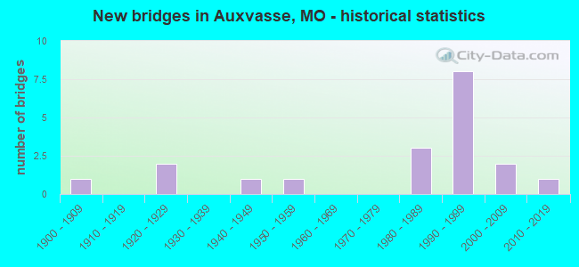
- New bridges - historical statistics
- 11900-1909
- 21920-1929
- 11940-1949
- 11950-1959
- 31980-1989
- 81990-1999
- 22000-2009
- 12010-2019

- Reconstructed bridges - Historical Statistics
- 11970-1979
- 21980-1989
- 11990-1999


- Bridge Condition - Deck
- 7.7%Excellent
- 23.1%Very good
- 30.8%Good
- 38.5%Satisfactory

- Bridge Condition - Superstructure
- 7.7%Excellent
- 76.9%Good
- 15.4%Satisfactory

- Bridge Condition - Substructure
- 7.7%Excellent
- 46.2%Very good
- 23.1%Good
- 15.4%Satisfactory
- 7.7%Fair

- Bridge Condition - Channel
- 25.0%Good
- 56.3%Satisfactory
- 18.8%Fair

- Bridge Condition - Culverts
- 25.0%Good
- 50.0%Satisfactory
- 25.0%Fair
Find on map >> Show street view
Structure Number: 13611, Location: S 5 T 49 N R 9 W (Lat: 39.051222, Lng: -91.947556), Route carried "on" structure: County highway 43, Year Built: 1996, Status: Open, Structure Length: 1.55m (5.09ft), Average Daily Traffic: 40 (year 2021), Truck Traffic: 5%, Average Future Daily Traffic: 60 (year 2041), Features Intersected: BYNUM CR, Facility Carried by Structure: COUNTY RD 2002
Minimum Vertical Clearance: 30+ m (98+ ft), Kilometerpoint: 1.609, Lanes on structure: 2, Owner: County Highway Agency, Approaching Roadway Width: 7.9m (25.9ft), Material/Design: Steel, Design/Construction: Stringer/Multi-beam, Number Of Spans In Main Unit: 1, Length of Maximum Span: 14.3m (46.9ft), Curb-To-Curb Width: 7.3m (24.0ft), Out-to-Out Width: 7.5m (24.6ft)
Condition: Deck: Very good, Superstructure: Good, Substructure: Very good, Channel: Satisfactory, Operating Rating: 72.9 metric tons, Method Used To Determine Operating Rating: Load Factor (LF), Inventory Rating: 34.2 metric tons, Method Used To Determine Inventory Rating: Load Factor (LF), Structural Evaluation: Better than present minimum criteria, Deck Geometry: Equal to present minimum criteria, Waterway Adequacy: Better than present minimum criteria, Approach Roadway Alignment: Equal to present desirable criteria, Designated Inspection Frequency: Every 24 months, Inspection Date: October 2020, Deck Structure Type: Concrete Cast-file-Place
Find on map >> Show street view
Structure Number: 13715, Location: S 3 T 49 N R 9 W (Lat: 39.050667, Lng: -91.901028), Route carried "on" structure: County highway 45, Year Built: 1995, Status: Open, Structure Length: 0.91m (2.99ft), Average Daily Traffic: 50 (year 2021), Truck Traffic: 10%, Average Future Daily Traffic: 75 (year 2041), Features Intersected: SMITH BR, Facility Carried by Structure: COUNTY RD 2002
Minimum Vertical Clearance: 30+ m (98+ ft), Kilometerpoint: 3.541, Lanes on structure: 2, Owner: County Highway Agency, Approaching Roadway Width: 6.7m (22.0ft), Material/Design: Steel, Design/Construction: Stringer/Multi-beam, Number Of Spans In Main Unit: 1, Length of Maximum Span: 8.2m (26.9ft), Curb-To-Curb Width: 6.7m (22.0ft), Out-to-Out Width: 6.9m (22.6ft)
Condition: Deck: Very good, Superstructure: Good, Substructure: Good, Channel: Fair, Operating Rating: 89.1 metric tons, Method Used To Determine Operating Rating: Load Factor (LF), Inventory Rating: 53.1 metric tons, Method Used To Determine Inventory Rating: Load Factor (LF), Structural Evaluation: Better than present minimum criteria, Deck Geometry: Somewhat better than minimum adequacy, Waterway Adequacy: Better than present minimum criteria, Approach Roadway Alignment: Equal to present desirable criteria, Designated Inspection Frequency: Every 24 months, Inspection Date: October 2020, Deck Structure Type: Concrete Cast-file-Place
Find on map >> Show street view
Structure Number: 13842, Location: S 21 T 49 N R 9 W (Lat: 39.015056, Lng: -91.926444), Route carried "on" structure: County highway 49, Year Built: 1989, Status: Open, Structure Length: 1.83m (6.00ft), Average Daily Traffic: 60 (year 2021), Truck Traffic: 10%, Average Future Daily Traffic: 90 (year 2041), Features Intersected: BYNUM CR, Facility Carried by Structure: COUNTY RD 262
Minimum Vertical Clearance: 30+ m (98+ ft), Kilometerpoint: 1.770, Lanes on structure: 2, Owner: County Highway Agency, Approaching Roadway Width: 6.7m (22.0ft), Material/Design: Steel, Design/Construction: Stringer/Multi-beam, Number Of Spans In Main Unit: 1, Length of Maximum Span: 17.1m (56.1ft), Curb-To-Curb Width: 6.0m (19.7ft), Out-to-Out Width: 6.3m (20.7ft)
Condition: Deck: Satisfactory, Superstructure: Satisfactory, Substructure: Very good, Channel: Satisfactory, Operating Rating: 62.1 metric tons, Method Used To Determine Operating Rating: Allowable Stress (AS), Inventory Rating: 44.1 metric tons, Method Used To Determine Inventory Rating: Allowable Stress (AS), Structural Evaluation: Equal to present minimum criteria, Deck Geometry: Meets minimum limits, Waterway Adequacy: Better than present minimum criteria, Approach Roadway Alignment: Equal to present minimum criteria, Designated Inspection Frequency: Every 24 months, Inspection Date: October 2020, Deck Structure Type: Concrete Cast-file-Place, Wearing Surface/Protective System: Wearing Surface: Monolithic Concrete
Find on map >> Show street view
Structure Number: 13916, Location: S 22 T 49 N R 9 W (Lat: 39.010694, Lng: -91.914944), Route carried "on" structure: County highway 51, Year Built: 1989, Status: Open, Structure Length: 2.04m (6.69ft), Average Daily Traffic: 75 (year 2021), Truck Traffic: 10%, Average Future Daily Traffic: 113 (year 2041), Features Intersected: BYNUM CR, Facility Carried by Structure: COUNTY RD 260
Minimum Vertical Clearance: 30+ m (98+ ft), Kilometerpoint: 2.897, Lanes on structure: 2, Owner: County Highway Agency, Approaching Roadway Width: 6.4m (21.0ft), Material/Design: Steel, Design/Construction: Stringer/Multi-beam, Number Of Spans In Main Unit: 1, Length of Maximum Span: 19.2m (63.0ft), Curb-To-Curb Width: 5.8m (19.0ft), Out-to-Out Width: 6.1m (20.0ft)
Condition: Deck: Satisfactory, Superstructure: Good, Substructure: Good, Channel: Good, Operating Rating: 62.1 metric tons, Method Used To Determine Operating Rating: Allowable Stress (AS), Inventory Rating: 44.1 metric tons, Method Used To Determine Inventory Rating: Allowable Stress (AS), Structural Evaluation: Better than present minimum criteria, Deck Geometry: Meets minimum limits, Waterway Adequacy: Better than present minimum criteria, Approach Roadway Alignment: High priority of corrective action, Designated Inspection Frequency: Every 24 months, Inspection Date: October 2020, Deck Structure Type: Concrete Cast-file-Place, Wearing Surface/Protective System: Wearing Surface: Monolithic Concrete
Find on map >> Show street view
Structure Number: 13976, Location: S 27 T 49 N R 9 W (Lat: 38.996222, Lng: -91.907583), Route carried "on" structure: County highway 53, Year Built: 1984, Status: Open, Structure Length: 1.16m (3.81ft), Average Daily Traffic: 20 (year 2021), Truck Traffic: 10%, Average Future Daily Traffic: 30 (year 2041), Features Intersected: BYNUM CR, Facility Carried by Structure: COUNTY RD 250
Minimum Vertical Clearance: 30+ m (98+ ft), Kilometerpoint: 0.805, Lanes on structure: 1, Owner: County Highway Agency, Approaching Roadway Width: 5.2m (17.1ft), Material/Design: Steel, Design/Construction: Stringer/Multi-beam, Number Of Spans In Main Unit: 1, Length of Maximum Span: 11.6m (38.1ft), Curb-To-Curb Width: 3.7m (12.1ft), Out-to-Out Width: 3.8m (12.5ft)
Condition: Deck: Satisfactory, Superstructure: Satisfactory, Substructure: Satisfactory, Channel: Fair, Operating Rating: 62.1 metric tons, Method Used To Determine Operating Rating: Allowable Stress (AS), Inventory Rating: 38.7 metric tons, Method Used To Determine Inventory Rating: Allowable Stress (AS), Structural Evaluation: Equal to present minimum criteria, Deck Geometry: Meets minimum limits, Waterway Adequacy: Better than present minimum criteria, Approach Roadway Alignment: Equal to present desirable criteria, Designated Inspection Frequency: Every 24 months, Inspection Date: October 2020, Deck Structure Type: Concrete Cast-file-Place, Wearing Surface/Protective System: Wearing Surface: Monolithic Concrete
Find on map >> Show street view
Structure Number: 2309, Location: S 2 T 49 N R 9 W (Lat: 39.061722, Lng: -91.886333), Route carried "on" structure: County highway 389, Year Built: 1999, Status: Open, Structure Length: 1.40m (4.59ft), Average Daily Traffic: 50 (year 2021), Truck Traffic: 10%, Average Future Daily Traffic: 75 (year 2041), Features Intersected: JESSE CR, Facility Carried by Structure: COUNTY RD 1068
Minimum Vertical Clearance: 30+ m (98+ ft), Kilometerpoint: 0.805, Lanes on structure: 2, Owner: County Highway Agency, Approaching Roadway Width: 6.7m (22.0ft), Skew: 2 degrees, Material/Design: Steel, Design/Construction: Stringer/Multi-beam, Number Of Spans In Main Unit: 1, Length of Maximum Span: 13.1m (43.0ft), Curb-To-Curb Width: 6.1m (20.0ft), Out-to-Out Width: 6.6m (21.7ft)
Condition: Deck: Good, Superstructure: Good, Substructure: Good, Channel: Satisfactory, Operating Rating: 63.9 metric tons, Method Used To Determine Operating Rating: Load Factor (LF), Inventory Rating: 37.8 metric tons, Method Used To Determine Inventory Rating: Load Factor (LF), Structural Evaluation: Better than present minimum criteria, Deck Geometry: Somewhat better than minimum adequacy, Waterway Adequacy: Better than present minimum criteria, Approach Roadway Alignment: Equal to present desirable criteria, Designated Inspection Frequency: Every 24 months, Inspection Date: October 2020, Deck Structure Type: Concrete Cast-file-Place, Wearing Surface/Protective System: Wearing Surface: Monolithic Concrete
Find on map >> Show street view
Structure Number: 23359, Location: S 30 T 49 N R 8 W (Lat: 38.995389, Lng: -91.846861), Route carried "on" structure: County highway 406, Year Built: 1920, Year Reconstructed: 1988, Status: Open, Structure Length: 1.55m (5.09ft), Average Daily Traffic: 100 (year 2021), Truck Traffic: 5%, Average Future Daily Traffic: 150 (year 2041), Design Load: HS 20, Features Intersected: YATES BR, Facility Carried by Structure: COUNTY RD 166
Minimum Vertical Clearance: 30+ m (98+ ft), Kilometerpoint: 0.322, Lanes on structure: 2, Owner: County Highway Agency, Approaching Roadway Width: 6.7m (22.0ft), Material/Design: Steel, Design/Construction: Stringer/Multi-beam, Number Of Spans In Main Unit: 1, Length of Maximum Span: 14.6m (47.9ft), Curb-To-Curb Width: 5.9m (19.4ft), Out-to-Out Width: 6.1m (20.0ft)
Condition: Deck: Satisfactory, Superstructure: Good, Substructure: Very good, Channel: Good, Operating Rating: 42.3 metric tons, Method Used To Determine Operating Rating: Allowable Stress (AS), Inventory Rating: 16.2 metric tons, Method Used To Determine Inventory Rating: Allowable Stress (AS), Structural Evaluation: Somewhat better than minimum adequacy, Deck Geometry: Meets minimum limits, Waterway Adequacy: Better than present minimum criteria, Approach Roadway Alignment: Equal to present desirable criteria, Designated Inspection Frequency: Every 24 months, Inspection Date: October 2020, Deck Structure Type: Concrete Cast-file-Place, Wearing Surface/Protective System: Wearing Surface: Monolithic Concrete
Find on map >> Show street view
Structure Number: 23368, Location: S 29 T 49 N R 8 W (Lat: 38.992417, Lng: -91.837472), Route carried "on" structure: County highway 406, Year Built: 1905, Year Reconstructed: 1988, Status: Open, Structure Length: 1.74m (5.71ft), Average Daily Traffic: 50 (year 2021), Truck Traffic: 5%, Average Future Daily Traffic: 75 (year 2041), Design Load: H 20, Features Intersected: HARRISON CR, Facility Carried by Structure: COUNTY RD 166
Minimum Vertical Clearance: 30+ m (98+ ft), Kilometerpoint: 0.966, Lanes on structure: 2, Owner: County Highway Agency, Approaching Roadway Width: 7.3m (24.0ft), Material/Design: Steel, Design/Construction: Stringer/Multi-beam, Number Of Spans In Main Unit: 1, Length of Maximum Span: 17.4m (57.1ft), Curb-To-Curb Width: 5.9m (19.4ft), Out-to-Out Width: 6.1m (20.0ft)
Condition: Deck: Satisfactory, Superstructure: Good, Substructure: Very good, Channel: Satisfactory, Operating Rating: 38.7 metric tons, Method Used To Determine Operating Rating: Allowable Stress (AS), Inventory Rating: 26.1 metric tons, Method Used To Determine Inventory Rating: Allowable Stress (AS), Structural Evaluation: Equal to present minimum criteria, Deck Geometry: Meets minimum limits, Waterway Adequacy: Better than present minimum criteria, Approach Roadway Alignment: Better than present minimum criteria, Designated Inspection Frequency: Every 24 months, Inspection Date: October 2020, Deck Structure Type: Concrete Cast-file-Place, Wearing Surface/Protective System: Wearing Surface: Monolithic Concrete
Find on map >> Show street view
Structure Number: 2856, Location: S 8 T 49 N R 9 W (Lat: 39.040056, Lng: -91.938306), Route carried "on" structure: County highway 47, Year Built: 2000, Status: Open, Structure Length: 1.89m (6.20ft), Average Daily Traffic: 40 (year 2021), Truck Traffic: 5%, Average Future Daily Traffic: 60 (year 2041), Features Intersected: BYNUM CR, Facility Carried by Structure: COUNTY RD 280
Minimum Vertical Clearance: 30+ m (98+ ft), Kilometerpoint: 0.000, Lanes on structure: 2, Owner: County Highway Agency, Approaching Roadway Width: 7.3m (24.0ft), Material/Design: Steel, Design/Construction: Stringer/Multi-beam, Number Of Spans In Main Unit: 1, Length of Maximum Span: 18.9m (62.0ft), Curb-To-Curb Width: 7.2m (23.6ft), Out-to-Out Width: 7.3m (24.0ft)
Condition: Deck: Good, Superstructure: Good, Substructure: Very good, Channel: Satisfactory, Operating Rating: 68.4 metric tons, Method Used To Determine Operating Rating: Load Factor (LF), Inventory Rating: 40.5 metric tons, Method Used To Determine Inventory Rating: Load Factor (LF), Structural Evaluation: Better than present minimum criteria, Deck Geometry: Somewhat better than minimum adequacy, Waterway Adequacy: Better than present minimum criteria, Approach Roadway Alignment: Equal to present desirable criteria, Designated Inspection Frequency: Every 24 months, Inspection Date: October 2020, Deck Structure Type: Concrete Cast-file-Place
Find on map >> Show street view
Structure Number: 3262, Location: S 11 T 49 N R 9 W (Lat: 39.039667, Lng: -91.886350), Route carried "on" structure: County highway 387, Year Built: 2007, Status: Open, Structure Length: 1.68m (5.51ft), Average Daily Traffic: 40 (year 2021), Truck Traffic: 10%, Average Future Daily Traffic: 60 (year 2041), Design Load: HS 20, Features Intersected: JESSE CR, Facility Carried by Structure: COUNTY RD 1048
Minimum Vertical Clearance: 30+ m (98+ ft), Kilometerpoint: 0.000, Lanes on structure: 2, Owner: County Highway Agency, Approaching Roadway Width: 7.9m (25.9ft), Skew: 1 degrees, Material/Design: Steel, Design/Construction: Stringer/Multi-beam, Number Of Spans In Main Unit: 1, Length of Maximum Span: 16.8m (55.1ft), Curb-To-Curb Width: 8.2m (26.9ft), Out-to-Out Width: 8.4m (27.6ft)
Condition: Deck: Very good, Superstructure: Good, Substructure: Very good, Channel: Satisfactory, Operating Rating: 66.6 metric tons, Method Used To Determine Operating Rating: Load Factor (LF), Inventory Rating: 39.6 metric tons, Method Used To Determine Inventory Rating: Load Factor (LF), Structural Evaluation: Better than present minimum criteria, Deck Geometry: Equal to present minimum criteria, Waterway Adequacy: Better than present minimum criteria, Approach Roadway Alignment: Equal to present minimum criteria, Designated Inspection Frequency: Every 24 months, Inspection Date: October 2020, Deck Structure Type: Concrete Cast-file-Place, Wearing Surface/Protective System: Wearing Surface: Monolithic Concrete
Find on map >> Show street view
Structure Number: 33151, Location: S 2 T 49 N R 9 W (Lat: 39.049369, Lng: -91.894842), Route carried "on" structure: County highway , Year Built: 2010, Status: Open, Structure Length: 1.98m (6.50ft), Average Daily Traffic: 158 (year 2021), Truck Traffic: 10%, Average Future Daily Traffic: 245 (year 2041), Design Load: HS 20, Features Intersected: SMITH BR, Facility Carried by Structure: OLD 54 S
Minimum Vertical Clearance: 30+ m (98+ ft), Kilometerpoint: 0.224, Lanes on structure: 2, Owner: State Highway Agency, Approaching Roadway Width: 7.3m (24.0ft), Material/Design: Prestressed concrete, Design/Construction: Box Beam or Girders - Multiple, Number Of Spans In Main Unit: 1, Length of Maximum Span: 19.8m (65.0ft), Curb-To-Curb Width: 9.4m (30.8ft), Out-to-Out Width: 10.1m (33.1ft)
Condition: Deck: Excellent, Superstructure: Excellent, Substructure: Excellent, Channel: Good, Operating Rating: 63.0 metric tons, Method Used To Determine Operating Rating: Load Factor (LF), Inventory Rating: 37.8 metric tons, Method Used To Determine Inventory Rating: Load Factor (LF), Structural Evaluation: Superior to present desirable criteria, Deck Geometry: Equal to present minimum criteria, Waterway Adequacy: Superior to present desirable criteria, Approach Roadway Alignment: Equal to present desirable criteria, Designated Inspection Frequency: Every 24 months, Inspection Date: October 2020, Deck Structure Type: Concrete Precast Panels, Wearing Surface/Protective System: Wearing Surface: Bituminous
Find on map >> Show street view
Structure Number: 382, Location: S 20 T 49 N R 8 W (Lat: 39.016986, Lng: -91.828294), Route carried "on" structure: State highway B, Year Built: 1959, Year Reconstructed: 1983, Status: Open, Structure Length: 3.11m (10.20ft), Average Daily Traffic: 1,087 (year 2021), Truck Traffic: 13%, Average Future Daily Traffic: 1,685 (year 2041), Design Load: H 15, Features Intersected: HARRISON CR
Minimum Vertical Clearance: 30+ m (98+ ft), Kilometerpoint: 5.123, Lanes on structure: 2, Owner: State Highway Agency, Approaching Roadway Width: 6.1m (20.0ft), Material/Design: Concrete continuous, Design/Construction: Slab, Number Of Spans In Main Unit: 3, Length of Maximum Span: 10.4m (34.1ft), Curb or Sidewalk Widths: Left: 0.2m (0.7ft), Right: 0.2m (0.7ft), Curb-To-Curb Width: 7.6m (24.9ft), Out-to-Out Width: 8.4m (27.6ft)
Condition: Deck: Good, Superstructure: Good, Substructure: Fair, Channel: Good, Operating Rating: 37.8 metric tons, Method Used To Determine Operating Rating: Load Factor (LF), Inventory Rating: 22.5 metric tons, Method Used To Determine Inventory Rating: Load Factor (LF), Structural Evaluation: Somewhat better than minimum adequacy, Deck Geometry: Meets minimum limits, Waterway Adequacy: Equal to present minimum criteria, Approach Roadway Alignment: Equal to present desirable criteria, Designated Inspection Frequency: Every 24 months, Inspection Date: October 2020, Deck Structure Type: Concrete Cast-file-Place, Wearing Surface/Protective System: Wearing Surface: Bituminous
Find on map >> Show street view
Structure Number: 3899, Location: S 2 T 49 N R 9 W (Lat: 39.049092, Lng: -91.893792), Route carried "on" structure: US 54, Year Built: 1990, Status: Open, Structure Length: 0.69m (2.26ft), Average Daily Traffic: 5,437 (year 2021), Truck Traffic: 28%, Average Future Daily Traffic: 10,058 (year 2041), Design Load: HS 20+Mod, Features Intersected: SMITH BR
Minimum Vertical Clearance: 30+ m (98+ ft), Kilometerpoint: 333.235, Lanes on structure: 4, Base Highway Network: Yes, Owner: State Highway Agency, Approaching Roadway Width: 39.0m (128.0ft), Skew: 2 degrees, Material/Design: Concrete continuous, Design/Construction: Culvert, Number Of Spans In Main Unit: 2, Length of Maximum Span: 3.4m (11.2ft)
Condition: Channel: Satisfactory, Culverts: Good, Inventory Rating: 70.2 metric tons, Method Used To Determine Inventory Rating: Load Factor (LF), Structural Evaluation: Better than present minimum criteria, Waterway Adequacy: Equal to present desirable criteria, Approach Roadway Alignment: Equal to present desirable criteria, Designated Inspection Frequency: Every 24 months, Inspection Date: October 2020
Find on map >> Show street view
Structure Number: 39, Location: S 14 T 49 N R 9 W (Lat: 39.017875, Lng: -91.886328), Route carried "on" structure: State highway B, Year Built: 1990, Status: Open, Structure Length: 9.20m (30.18ft), Average Daily Traffic: 1,087 (year 2021), Truck Traffic: 13%, Average Future Daily Traffic: 1,685 (year 2041), Design Load: HS 20+Mod, Features Intersected: US 54
Minimum Vertical Clearance: 30+ m (98+ ft), Kilometerpoint: 0.064, Lanes on structure: 2, Lanes under structure: 4, Owner: State Highway Agency, Approaching Roadway Width: 10.4m (34.1ft), Skew: 1 degrees, Material/Design: Steel continuous, Design/Construction: Stringer/Multi-beam, Number Of Spans In Main Unit: 2, Length of Maximum Span: 37.6m (123.4ft), Curb or Sidewalk Widths: Left: 0.2m (0.7ft), Right: 0.2m (0.7ft), Curb-To-Curb Width: 10.0m (32.8ft), Out-to-Out Width: 10.8m (35.4ft)
Condition: Deck: Good, Superstructure: Good, Substructure: Satisfactory, Operating Rating: 60.3 metric tons, Method Used To Determine Operating Rating: Load Factor (LF), Inventory Rating: 36.0 metric tons, Method Used To Determine Inventory Rating: Load Factor (LF), Structural Evaluation: Equal to present minimum criteria, Deck Geometry: Somewhat better than minimum adequacy, Underclear: Equal to present desirable criteria, Approach Roadway Alignment: Equal to present desirable criteria, Designated Inspection Frequency: Every 24 months, Inspection Date: October 2020, Deck Structure Type: Concrete Cast-file-Place, Wearing Surface/Protective System: Wearing Surface: Monolithic Concrete, Deck Protection: Internally Sealed
Find on map >> Show street view
Structure Number: 3901, Location: S 23 T 49 N R 9 W (Lat: 39.003156, Lng: -91.893036), Route carried "on" structure: US 54, Year Built: 1990, Status: Open, Structure Length: 0.74m (2.43ft), Average Daily Traffic: 12,079 (year 2021), Truck Traffic: 14%, Average Future Daily Traffic: 22,346 (year 2041), Design Load: HS 20+Mod, Features Intersected: BR
Minimum Vertical Clearance: 30+ m (98+ ft), Kilometerpoint: 327.842, Lanes on structure: 4, Base Highway Network: Yes, Owner: State Highway Agency, Approaching Roadway Width: 39.0m (128.0ft), Skew: 4 degrees, Material/Design: Concrete continuous, Design/Construction: Culvert, Number Of Spans In Main Unit: 2, Length of Maximum Span: 3.7m (12.1ft)
Condition: Channel: Fair, Culverts: Satisfactory, Inventory Rating: 60.3 metric tons, Method Used To Determine Inventory Rating: Load Factor (LF), Structural Evaluation: Equal to present minimum criteria, Waterway Adequacy: Equal to present desirable criteria, Approach Roadway Alignment: Equal to present desirable criteria, Designated Inspection Frequency: Every 24 months, Inspection Date: October 2020
Find on map >> Show street view
Structure Number: 5033, Location: S 2 T 49 N R 9 W (Lat: 39.060322, Lng: -91.894667), Route carried "on" structure: US 54, Year Built: 1927, Year Reconstructed: 2004, Status: Open, Structure Length: 0.64m (2.10ft), Average Daily Traffic: 5,167 (year 2021), Truck Traffic: 24%, Average Future Daily Traffic: 9,559 (year 2041), Design Load: H 15, Features Intersected: JESSE CR
Minimum Vertical Clearance: 30+ m (98+ ft), Kilometerpoint: 104.181, Lanes on structure: 2, Base Highway Network: Yes, Owner: State Highway Agency, Approaching Roadway Width: 13.4m (44.0ft), Material/Design: Concrete continuous, Design/Construction: Culvert, Number Of Spans In Main Unit: 2, Length of Maximum Span: 3.0m (9.8ft), Curb-To-Curb Width: 11.3m (37.1ft), Out-to-Out Width: 12.1m (39.7ft)
Condition: Channel: Satisfactory, Culverts: Fair, Operating Rating: 79.2 metric tons, Method Used To Determine Operating Rating: Load Factor (LF), Inventory Rating: 47.7 metric tons, Method Used To Determine Inventory Rating: Load Factor (LF), Structural Evaluation: Somewhat better than minimum adequacy, Deck Geometry: Equal to present minimum criteria, Waterway Adequacy: Equal to present desirable criteria, Approach Roadway Alignment: Equal to present desirable criteria, Designated Inspection Frequency: Every 24 months, Inspection Date: October 2020
Find on map >> Show street view
Structure Number: 9671, Location: S 16 T 49 N R 9 W (Lat: 39.025583, Lng: -91.928869), Route carried "on" structure: State highway E, Year Built: 1947, Status: Open, Structure Length: 0.76m (2.49ft), Average Daily Traffic: 863 (year 2021), Truck Traffic: 14%, Average Future Daily Traffic: 1,338 (year 2041), Design Load: H 10, Features Intersected: BYNUM CR
Minimum Vertical Clearance: 30+ m (98+ ft), Kilometerpoint: 17.548, Lanes on structure: 2, Owner: State Highway Agency, Approaching Roadway Width: 7.3m (24.0ft), Material/Design: Concrete continuous, Design/Construction: Culvert, Number Of Spans In Main Unit: 2, Length of Maximum Span: 3.7m (12.1ft), Curb-To-Curb Width: 7.3m (24.0ft), Out-to-Out Width: 7.9m (25.9ft)
Condition: Channel: Satisfactory, Culverts: Satisfactory, Operating Rating: 37.8 metric tons, Method Used To Determine Operating Rating: Load Factor (LF), Inventory Rating: 22.5 metric tons, Method Used To Determine Inventory Rating: Load Factor (LF), Structural Evaluation: Equal to present minimum criteria, Deck Geometry: Meets minimum limits, Waterway Adequacy: Equal to present desirable criteria, Approach Roadway Alignment: Equal to present desirable criteria, Designated Inspection Frequency: Every 24 months, Inspection Date: October 2020
Find on map >> Show street view
Structure Number: 39, Location: S 14 T 49 N R 9 W (Lat: 39.017875, Lng: -91.886328), Route carried "under" structure: US 54, Year Built: 1990, Structure Length: 0. m, Average Daily Traffic: 5,167 (year 2021), Truck Traffic: 24%, Features Intersected: US 54, Facility Carried by Structure: RT B E
Minimum Vertical Clearance: 5.51m (18.08ft), Kilometerpoint: 107.807, Lanes on structure: 2, Lanes under structure: 2, Material/Design: Steel continuous, Design/Construction: Stringer/Multi-beam, Length of Maximum Span: 37.6m (123.4ft)
Find on map >> Show street view
Structure Number: 39, Location: S 14 T 49 N R 9 W (Lat: 39.017875, Lng: -91.886328), Route carried "under" structure: US 54, Year Built: 1990, Structure Length: 0. m, Average Daily Traffic: 5,976 (year 2021), Truck Traffic: 19%, Features Intersected: US 54, Facility Carried by Structure: RT B E
Minimum Vertical Clearance: 5.08m (16.67ft), Kilometerpoint: 329.622, Lanes on structure: 2, Lanes under structure: 2, Material/Design: Steel continuous, Design/Construction: Stringer/Multi-beam, Length of Maximum Span: 37.6m (123.4ft)