Bridge Statistics for Avis, Pennsylvania (PA)
Condition, Traffic, Stress, Structural Evaluation, Project Costs
- National Bridge Inventory (NBI) Statistics
- 10Number of bridges
- 95ft / 29.3mTotal length
- $565,000Total costs
- 64,307Total average daily traffic
- 8,964Total average daily truck traffic
- National Bridge Inventory (NBI) Registered Bridges for Avis
- No street view available for this location
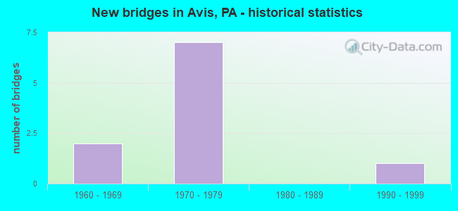
- New bridges - historical statistics
- 21960-1969
- 71970-1979
- 11990-1999


- Bridge Condition - Deck
- 75.0%Good
- 25.0%Fair

- Bridge Condition - Superstructure
- 75.0%Good
- 25.0%Satisfactory

- Bridge Condition - Substructure
- 50.0%Good
- 25.0%Satisfactory
- 25.0%Fair
Find on map >> Show street view
Structure Number: 12232, Location: 1 MILE SOUTH AVIS (Lat: 41.176339, Lng: -77.324392), Route carried "on" structure: US 220, Year Built: 1976, Status: Open, Structure Length: 3.41m (11.19ft), Average Daily Traffic: 8,547 (year 2021), Truck Traffic: 17%, Average Future Daily Traffic: 11,180 (year 2041), Design Load: HS 20, Features Intersected: SR 150-PA 150
Minimum Vertical Clearance: 30+ m (98+ ft), Kilometerpoint: 22.996, Lanes on structure: 2, Lanes under structure: 2, Base Highway Network: Yes, Owner: State Highway Agency, Approaching Roadway Width: 11.6m (38.1ft), Skew: 2 degrees, Material/Design: Steel, Design/Construction: Stringer/Multi-beam, Number Of Spans In Main Unit: 1, Length of Maximum Span: 32.9m (107.9ft), Curb or Sidewalk Widths: Left: 0.2m (0.7ft), Right: 0.2m (0.7ft), Curb-To-Curb Width: 12.6m (41.3ft), Out-to-Out Width: 13.4m (44.0ft)
Condition: Deck: Good, Superstructure: Good, Substructure: Good, Operating Rating: 73.5 metric tons, Method Used To Determine Operating Rating: Load Factor (LF), Inventory Rating: 43.5 metric tons, Method Used To Determine Inventory Rating: Load Factor (LF), Structural Evaluation: Better than present minimum criteria, Deck Geometry: Better than present minimum criteria, Underclear: Equal to present minimum criteria, Approach Roadway Alignment: Equal to present desirable criteria, Length Of Structure Improvement: 3.40m (11.15ft), Designated Inspection Frequency: Every 24 months, Inspection Date: April 2021, Deck Structure Type: Concrete Cast-file-Place, Wearing Surface/Protective System: Wearing Surface: Latex Concrete
Find on map >> Show street view
Structure Number: 12233, Location: 1 MILE SOUTH AVIS (Lat: 41.176567, Lng: -77.324536), Route carried "on" structure: US 220, Year Built: 1976, Status: Open, Structure Length: 3.41m (11.19ft), Average Daily Traffic: 8,740 (year 2021), Truck Traffic: 13%, Average Future Daily Traffic: 12,269 (year 2041), Design Load: HS 20, Features Intersected: SR 150-PA 150
Minimum Vertical Clearance: 30+ m (98+ ft), Kilometerpoint: 22.999, Lanes on structure: 2, Lanes under structure: 2, Base Highway Network: Yes, Owner: State Highway Agency, Approaching Roadway Width: 11.6m (38.1ft), Skew: 1 degrees, Material/Design: Steel, Design/Construction: Stringer/Multi-beam, Number Of Spans In Main Unit: 1, Length of Maximum Span: 32.9m (107.9ft), Curb or Sidewalk Widths: Left: 0.2m (0.7ft), Right: 0.2m (0.7ft), Curb-To-Curb Width: 12.6m (41.3ft), Out-to-Out Width: 13.4m (44.0ft)
Condition: Deck: Good, Superstructure: Good, Substructure: Fair, Operating Rating: 73.5 metric tons, Method Used To Determine Operating Rating: Load Factor (LF), Inventory Rating: 43.5 metric tons, Method Used To Determine Inventory Rating: Load Factor (LF), Structural Evaluation: Somewhat better than minimum adequacy, Deck Geometry: Better than present minimum criteria, Underclear: Equal to present minimum criteria, Approach Roadway Alignment: Equal to present desirable criteria, Length Of Structure Improvement: 3.40m (11.15ft), Designated Inspection Frequency: Every 24 months, Inspection Date: April 2021, Bridge Improvement Cost: $42,000, Roadway Improvement Cost: $250,000, Total Project Cost: $565,000, Deck Structure Type: Concrete Cast-file-Place, Wearing Surface/Protective System: Wearing Surface: Latex Concrete
Find on map >> Show street view
Structure Number: 12296, Location: AVIS BORO (Lat: 41.187922, Lng: -77.303097), Route carried "on" structure: State highway , Year Built: 1974, Status: Open, Structure Length: 11.61m (38.09ft), Average Daily Traffic: 3,368 (year 2020), Truck Traffic: 4%, Average Future Daily Traffic: 5,785 (year 2041), Design Load: HS 20, Features Intersected: SR 220-US 220, Facility Carried by Structure: SR 1016
Minimum Vertical Clearance: 30+ m (98+ ft), Kilometerpoint: 1.809, Lanes on structure: 2, Lanes under structure: 8, Owner: State Highway Agency, Approaching Roadway Width: 9.4m (30.8ft), Skew: 5 degrees, Material/Design: Steel, Design/Construction: Stringer/Multi-beam, Number Of Spans In Main Unit: 4, Length of Maximum Span: 38.7m (127.0ft), Curb or Sidewalk Widths: Left: 0.2m (0.7ft), Right: 0.2m (0.7ft), Curb-To-Curb Width: 13.4m (44.0ft), Out-to-Out Width: 14.6m (47.9ft)
Condition: Deck: Fair, Superstructure: Satisfactory, Substructure: Satisfactory, Operating Rating: 79.8 metric tons, Method Used To Determine Operating Rating: Load Factor (LF), Inventory Rating: 48.1 metric tons, Method Used To Determine Inventory Rating: Load Factor (LF), Structural Evaluation: Equal to present minimum criteria, Deck Geometry: Better than present minimum criteria, Underclear: Meets minimum limits, Approach Roadway Alignment: Better than present minimum criteria, Length Of Structure Improvement: 11.60m (38.06ft), Designated Inspection Frequency: Every 24 months, Inspection Date: April 2021, Deck Structure Type: Concrete Cast-file-Place, Wearing Surface/Protective System: Wearing Surface: Latex Concrete
Find on map >> Show street view
Structure Number: 39574, Location: AVIS (Lat: 41.184767, Lng: -77.309222), Route carried "on" structure: State highway , Year Built: 1997, Status: Open, Structure Length: 10.85m (35.60ft), Average Daily Traffic: 2,868 (year 2022), Truck Traffic: 7%, Average Future Daily Traffic: 5,499 (year 2041), Design Load: HS 25 or greater, Features Intersected: PINE CREEK, Facility Carried by Structure: SR 1016
Minimum Vertical Clearance: 30+ m (98+ ft), Kilometerpoint: 3.135, Lanes on structure: 2, Owner: State Highway Agency, Approaching Roadway Width: 12.2m (40.0ft), Material/Design: Prestressed concrete continuous, Design/Construction: Stringer/Multi-beam, Number Of Spans In Main Unit: 3, Length of Maximum Span: 34.7m (113.8ft), Curb or Sidewalk Widths: Left: 0.2m (0.7ft), Right: 0.2m (0.7ft), Curb-To-Curb Width: 12.3m (40.4ft), Out-to-Out Width: 13.3m (43.6ft)
Condition: Deck: Good, Superstructure: Good, Substructure: Good, Channel: Very good, Operating Rating: 98.0 metric tons, Method Used To Determine Operating Rating: Load Factor (LF), Inventory Rating: 50.8 metric tons, Method Used To Determine Inventory Rating: Load Factor (LF), Structural Evaluation: Better than present minimum criteria, Deck Geometry: Equal to present minimum criteria, Waterway Adequacy: Superior to present desirable criteria, Approach Roadway Alignment: Equal to present desirable criteria, Length Of Structure Improvement: 11.80m (38.71ft), Designated Inspection Frequency: Every 24 months, Underwater Inspection Frequency: Every 60 months, Inspection Date: April 2021, Underwater Inspection Date: August 2020, Wearing Surface/Protective System: Wearing Surface: Monolithic Concrete, Deck Protection: Epoxy Coated Reinforcing
Find on map >> Show street view
Structure Number: 11989, Location: 1 MILE NORTHEAST AVIS (Lat: 41.196486, Lng: -77.297189), Route carried "under" structure: US 220, Year Built: 1966, Structure Length: 0. m, Average Daily Traffic: 8,644 (year 2021), Truck Traffic: 18%, Features Intersected: SR 220-US 220, Facility Carried by Structure: SR 44-PA 44
Minimum Vertical Clearance: 4.66m (15.29ft), Kilometerpoint: 26.097, Lanes on structure: 2, Lanes under structure: 4, Material/Design: Prestressed concrete, Design/Construction: Box Beam or Girders - Single/Spread, Length of Maximum Span: 16.8m (55.1ft)
Find on map >> Show street view
Structure Number: 11989, Location: 1 MILE NORTHEAST AVIS (Lat: 41.196486, Lng: -77.297189), Route carried "under" structure: US 220, Year Built: 1966, Structure Length: 0. m, Average Daily Traffic: 8,595 (year 2021), Truck Traffic: 17%, Features Intersected: SR 220-US 220, Facility Carried by Structure: SR 44-PA 44
Minimum Vertical Clearance: 4.61m (15.12ft), Kilometerpoint: 26.063, Lanes on structure: 2, Lanes under structure: 4, Material/Design: Prestressed concrete, Design/Construction: Box Beam or Girders - Single/Spread, Length of Maximum Span: 16.8m (55.1ft)
Find on map >> Show street view
Structure Number: 12232, Location: 1 MILE SOUTH AVIS (Lat: 41.176339, Lng: -77.324392), Route carried "under" structure: Ramp State highway 150, Year Built: 1976, Structure Length: 0. m, Average Daily Traffic: 3,129 (year 2021), Truck Traffic: 7%, Features Intersected: SR 150-PA 150, Facility Carried by Structure: SR 220-US 220
Minimum Vertical Clearance: 4.66m (15.29ft), Kilometerpoint: 26.852, Lanes on structure: 2, Lanes under structure: 2, Material/Design: Steel, Design/Construction: Stringer/Multi-beam, Length of Maximum Span: 32.9m (107.9ft)
Find on map >> Show street view
Structure Number: 12233, Location: 1 MILE SOUTH AVIS (Lat: 41.176567, Lng: -77.324536), Route carried "under" structure: Ramp State highway 150, Year Built: 1976, Structure Length: 0. m, Average Daily Traffic: 3,129 (year 2021), Truck Traffic: 7%, Features Intersected: SR 150-PA 150, Facility Carried by Structure: SR 220-US 220
Minimum Vertical Clearance: 4.50m (14.76ft), Kilometerpoint: 26.852, Lanes on structure: 2, Lanes under structure: 2, Material/Design: Steel, Design/Construction: Stringer/Multi-beam, Length of Maximum Span: 32.9m (107.9ft)
Find on map >> Show street view
Structure Number: 12296, Location: AVIS BORO (Lat: 41.187922, Lng: -77.303097), Route carried "under" structure: US 220, Year Built: 1974, Structure Length: 0. m, Average Daily Traffic: 8,547 (year 2021), Truck Traffic: 17%, Features Intersected: SR 220-US 220, Facility Carried by Structure: SR 1016
Minimum Vertical Clearance: 4.57m (14.99ft), Kilometerpoint: 25.357, Lanes on structure: 2, Lanes under structure: 4, Material/Design: Steel, Design/Construction: Stringer/Multi-beam, Length of Maximum Span: 38.7m (127.0ft)
Find on map >> Show street view
Structure Number: 12296, Location: AVIS BORO (Lat: 41.187922, Lng: -77.303097), Route carried "under" structure: US 220, Year Built: 1974, Structure Length: 0. m, Average Daily Traffic: 8,740 (year 2021), Truck Traffic: 13%, Features Intersected: SR 220-US 220, Facility Carried by Structure: SR 1016
Minimum Vertical Clearance: 4.77m (15.65ft), Kilometerpoint: 25.310, Lanes on structure: 2, Lanes under structure: 4, Material/Design: Steel, Design/Construction: Stringer/Multi-beam, Length of Maximum Span: 38.7m (127.0ft)