Bridge Statistics for Avoca, Indiana (IN)
Condition, Traffic, Stress, Structural Evaluation, Project Costs
- National Bridge Inventory (NBI) Statistics
- 18Number of bridges
- 164ft / 49.6mTotal length
- $1,600,000Total costs
- 42,781Total average daily traffic
- 5,889Total average daily truck traffic
- 72,541Total future (year 2030) average daily traffic
- National Bridge Inventory (NBI) Registered Bridges for Avoca
- No street view available for this location
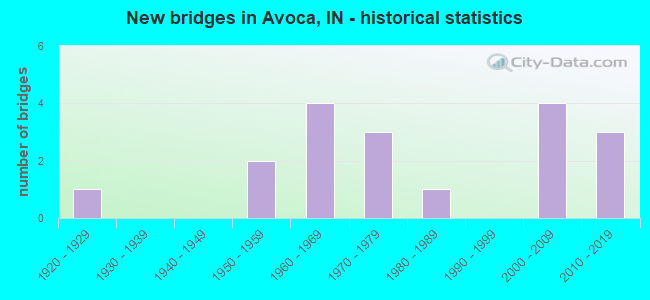
- New bridges - historical statistics
- 11920-1929
- 21950-1959
- 41960-1969
- 31970-1979
- 11980-1989
- 42000-2009
- 32010-2019

- Reconstructed bridges - Historical Statistics
- 11980-1989
- 21990-1999
- 02000-2009
- 42010-2019


- Bridge Condition - Deck
- 13.3%Very good
- 46.7%Good
- 20.0%Satisfactory
- 13.3%Fair
- 6.7%Poor

- Bridge Condition - Superstructure
- 60.0%Good
- 20.0%Satisfactory
- 13.3%Fair
- 6.7%Poor

- Bridge Condition - Substructure
- 26.7%Very good
- 46.7%Good
- 6.7%Satisfactory
- 20.0%Fair

- Bridge Condition - Channel
- 6.3%Very good
- 37.5%Good
- 25.0%Satisfactory
- 12.5%Fair
- 18.8%Poor

- Bridge Condition - Culverts
- 33.3%Good
- 33.3%Satisfactory
- 33.3%Fair
Find on map >> Show street view
Structure Number: 12, Location: 02.57 N SR 54 (Lat: 38.946261, Lng: -86.551950), Route carried "on" structure: State highway 37, Year Built: 1969, Year Reconstructed: 2015, Status: Open, Structure Length: 6.13m (20.11ft), Average Daily Traffic: 9,719 (year 2004), Truck Traffic: 10%, Average Future Daily Traffic: 13,460 (year 2034), Design Load: HS 20, Features Intersected: GULLETS CREEK
Minimum Vertical Clearance: 30+ m (98+ ft), Kilometerpoint: 32.316, Lanes on structure: 2, Base Highway Network: Yes (, Subroute: 1), Owner: State Highway Agency, Approaching Roadway Width: 11.6m (38.1ft), Skew: 3 degrees, Material/Design: Steel continuous, Design/Construction: Stringer/Multi-beam, Number Of Spans In Main Unit: 3, Length of Maximum Span: 23.1m (75.8ft), Curb-To-Curb Width: 12.0m (39.4ft), Out-to-Out Width: 12.9m (42.3ft)
Condition: Deck: Satisfactory, Superstructure: Good, Substructure: Good, Channel: Good, Operating Rating: 64.8 metric tons, Method Used To Determine Operating Rating: Load and Resistance Factor Rating (LRFR) rating reported by rating factor(RF) method using HL-93 loadings, Inventory Rating: 49.9 metric tons, Method Used To Determine Inventory Rating: Load and Resistance Factor Rating (LRFR) rating reported by rating factor(RF) method using HL-93 loadings, Structural Evaluation: Better than present minimum criteria, Deck Geometry: Better than present minimum criteria, Waterway Adequacy: Superior to present desirable criteria, Approach Roadway Alignment: Equal to present desirable criteria, Designated Inspection Frequency: Every 24 months, Inspection Date: December 2021, Deck Structure Type: Concrete Cast-file-Place, Wearing Surface/Protective System: Wearing Surface: Latex Concrete
Find on map >> Show street view
Structure Number: 1201, Location: 02.57 N SR 54 (Lat: 38.946339, Lng: -86.552261), Route carried "on" structure: State highway 37, Year Built: 1969, Year Reconstructed: 2015, Status: Open, Structure Length: 6.13m (20.11ft), Average Daily Traffic: 9,719 (year 2004), Truck Traffic: 10%, Average Future Daily Traffic: 13,460 (year 2034), Design Load: HS 20, Features Intersected: GULLETS CREEK
Minimum Vertical Clearance: 30+ m (98+ ft), Kilometerpoint: 32.316, Lanes on structure: 2, Base Highway Network: Yes (, Subroute: 1), Owner: State Highway Agency, Approaching Roadway Width: 11.6m (38.1ft), Skew: 3 degrees, Material/Design: Steel continuous, Design/Construction: Stringer/Multi-beam, Number Of Spans In Main Unit: 3, Length of Maximum Span: 23.1m (75.8ft), Curb-To-Curb Width: 12.0m (39.4ft), Out-to-Out Width: 12.9m (42.3ft)
Condition: Deck: Good, Superstructure: Good, Substructure: Good, Channel: Good, Operating Rating: 64.8 metric tons, Method Used To Determine Operating Rating: Load and Resistance Factor Rating (LRFR) rating reported by rating factor(RF) method using HL-93 loadings, Inventory Rating: 49.9 metric tons, Method Used To Determine Inventory Rating: Load and Resistance Factor Rating (LRFR) rating reported by rating factor(RF) method using HL-93 loadings, Structural Evaluation: Better than present minimum criteria, Deck Geometry: Better than present minimum criteria, Waterway Adequacy: Superior to present desirable criteria, Approach Roadway Alignment: Equal to present desirable criteria, Designated Inspection Frequency: Every 24 months, Inspection Date: December 2021, Deck Structure Type: Concrete Cast-file-Place, Wearing Surface/Protective System: Wearing Surface: Latex Concrete
Find on map >> Show street view
Structure Number: 1971, Location: 01.52 W SR 37 (Lat: 38.922961, Lng: -86.566250), Route carried "on" structure: State highway 54, Year Built: 2006, Status: Open, Structure Length: 2.15m (7.05ft), Average Daily Traffic: 4,962 (year 2004), Truck Traffic: 10%, Average Future Daily Traffic: 6,873 (year 2032), Design Load: HS 20+Mod, Features Intersected: GOOSE CREEK
Minimum Vertical Clearance: 30+ m (98+ ft), Kilometerpoint: 11.523, Lanes on structure: 2, Owner: State Highway Agency, Approaching Roadway Width: 12.2m (40.0ft), Skew: 4 degrees, Material/Design: Prestressed concrete, Design/Construction: Stringer/Multi-beam, Number Of Spans In Main Unit: 1, Length of Maximum Span: 20.7m (67.9ft), Curb-To-Curb Width: 12.2m (40.0ft), Out-to-Out Width: 13.1m (43.0ft)
Condition: Deck: Satisfactory, Superstructure: Good, Substructure: Very good, Channel: Very good, Operating Rating: 61.9 metric tons, Method Used To Determine Operating Rating: Load and Resistance Factor Rating (LRFR) rating reported by rating factor(RF) method using HL-93 loadings, Inventory Rating: 40.8 metric tons, Method Used To Determine Inventory Rating: Load and Resistance Factor Rating (LRFR) rating reported by rating factor(RF) method using HL-93 loadings, Structural Evaluation: Better than present minimum criteria, Deck Geometry: Equal to present minimum criteria, Waterway Adequacy: Equal to present desirable criteria, Approach Roadway Alignment: Equal to present desirable criteria, Designated Inspection Frequency: Every 24 months, Inspection Date: January 2022, Deck Structure Type: Concrete Cast-file-Place, Wearing Surface/Protective System: Wearing Surface: Monolithic Concrete, Deck Protection: Epoxy Coated Reinforcing
Find on map >> Show street view
Structure Number: 4701, Location: 00.92 E SR 49 (Lat: 41.571769, Lng: -87.028108), Route carried "on" structure: County highway , Year Built: 1956, Year Reconstructed: 1997, Status: Open, Structure Length: 6.61m (21.69ft), Average Daily Traffic: 714 (year 2004), Truck Traffic: 10%, Average Future Daily Traffic: 1,374 (year 2031), Design Load: HS 20, Features Intersected: I-90 EB/WB, Facility Carried by Structure: CR 200E
Minimum Vertical Clearance: 30+ m (98+ ft), Kilometerpoint: 0.000, Lanes on structure: 2, Lanes under structure: 4, Owner: State Toll Authority, Approaching Roadway Width: 9.8m (32.2ft), Material/Design: Steel, Design/Construction: Stringer/Multi-beam, Number Of Spans In Main Unit: 4, Length of Maximum Span: 19.7m (64.6ft), Curb-To-Curb Width: 8.2m (26.9ft), Out-to-Out Width: 9.1m (29.9ft)
Condition: Deck: Good, Superstructure: Good, Substructure: Good, Operating Rating: 94.1 metric tons, Method Used To Determine Operating Rating: Load Factor (LF), Inventory Rating: 56.3 metric tons, Method Used To Determine Inventory Rating: Load Factor (LF), Structural Evaluation: Better than present minimum criteria, Deck Geometry: Somewhat better than minimum adequacy, Underclear: Somewhat better than minimum adequacy, Approach Roadway Alignment: Equal to present desirable criteria, Designated Inspection Frequency: Every 24 months, Other Special Inspection Frequency: Every 24 months, Inspection Date: July 2021, Other Special Inspection Date: July 2021, Deck Structure Type: Concrete Cast-file-Place, Wearing Surface/Protective System: Wearing Surface: Monolithic Concrete
Find on map >> Show street view
Structure Number: 4702, Location: 01.42 E SR 49 (Lat: 41.571500, Lng: -87.018411), Route carried "on" structure: Interstate 90, Year Built: 1956, Year Reconstructed: 2018, Status: Open, Structure Length: 4.15m (13.62ft), Average Daily Traffic: 13,090 (year 2014), Truck Traffic: 24%, Average Future Daily Traffic: 30,000 (year 2031), Design Load: HS 20+Mod, Features Intersected: SATTLEY RD/CR 250 W
Minimum Vertical Clearance: 30+ m (98+ ft), Kilometerpoint: 52.288, Lanes on structure: 2, Lanes under structure: 2, Base Highway Network: Yes (, Subroute: 1), Toll: On toll road, Owner: State Toll Authority, Approaching Roadway Width: 12.8m (42.0ft), Material/Design: Steel, Design/Construction: Stringer/Multi-beam, Number Of Spans In Main Unit: 3, Length of Maximum Span: 11.6m (38.1ft), Curb-To-Curb Width: 9.8m (32.2ft), Out-to-Out Width: 10.7m (35.1ft)
Condition: Deck: Good, Superstructure: Satisfactory, Substructure: Good, Operating Rating: 80.0 metric tons, Method Used To Determine Operating Rating: Load Factor (LF), Inventory Rating: 48.0 metric tons, Method Used To Determine Inventory Rating: Load Factor (LF), Structural Evaluation: Equal to present minimum criteria, Deck Geometry: High priority of replacement, Underclear: High priority of corrective action, Approach Roadway Alignment: Equal to present desirable criteria, Designated Inspection Frequency: Every 24 months, Inspection Date: July 2021, Deck Structure Type: Concrete Cast-file-Place, Wearing Surface/Protective System: Wearing Surface: Latex Concrete
Find on map >> Show street view
Structure Number: 6042, Location: 00.00 AVOCA FISH HATCHERY (Lat: 38.909819, Lng: -86.549489), Route carried "on" structure: ServiceState lands road , Year Built: 1920, Year Reconstructed: 1980, Status: Posted for load-capacity, Structure Length: 1.22m (4.00ft), Average Daily Traffic: 143 (year 2004), Truck Traffic: 10%, Average Future Daily Traffic: 237 (year 2030), Design Load: H 20, Features Intersected: GOOSE CREEK, Facility Carried by Structure: HATCHERY ROAD
Minimum Vertical Clearance: 30+ m (98+ ft), Kilometerpoint: 0.000, Lanes on structure: 1, Owner: State Agenciy, Maintenance Responsibility: State Highway Agency, Approaching Roadway Width: 5.8m (19.0ft), Skew: 4 degrees, Material/Design: Steel continuous, Design/Construction: Stringer/Multi-beam, Number Of Spans In Main Unit: 3, Length of Maximum Span: 4.4m (14.4ft), Curb-To-Curb Width: 3.7m (12.1ft), Out-to-Out Width: 3.8m (12.5ft)
Condition: Deck: Good, Superstructure: Satisfactory, Substructure: Fair, Channel: Poor, Operating Rating: 46.6 metric tons, Method Used To Determine Operating Rating: Load Factor (LF), Inventory Rating: 27.9 metric tons, Method Used To Determine Inventory Rating: Load Factor (LF), Structural Evaluation: Somewhat better than minimum adequacy, Deck Geometry: High priority of replacement, Waterway Adequacy: Better than present minimum criteria, Approach Roadway Alignment: Equal to present desirable criteria, Designated Inspection Frequency: Every 24 months, Inspection Date: November 2021, Deck Structure Type: Concrete Cast-file-Place, Wearing Surface/Protective System: Wearing Surface: Monolithic Concrete
Find on map >> Show street view
Structure Number: 4700055, Location: 00.88 E OF McFADDEN RIDGE (Lat: 38.943150, Lng: -86.510119), Route carried "on" structure: County highway , Year Built: 1966, Year Reconstructed: 2016, Status: Open, Structure Length: 5.15m (16.90ft), Average Daily Traffic: 254 (year 2016), Truck Traffic: 4%, Average Future Daily Traffic: 305 (year 2036), Features Intersected: SALT CREEK, Facility Carried by Structure: JUDAH LOGAN ROAD
Minimum Vertical Clearance: 30+ m (98+ ft), Kilometerpoint: 0.000, Lanes on structure: 2, Owner: County Highway Agency, Approaching Roadway Width: 7.0m (23.0ft), Material/Design: Steel, Design/Construction: Stringer/Multi-beam, Number Of Spans In Main Unit: 3, Length of Maximum Span: 22.3m (73.2ft), Curb-To-Curb Width: 7.7m (25.3ft), Out-to-Out Width: 7.9m (25.9ft)
Condition: Deck: Very good, Superstructure: Good, Substructure: Satisfactory, Channel: Good, Operating Rating: 49.1 metric tons, Method Used To Determine Operating Rating: Load Factor (LF), Inventory Rating: 29.4 metric tons, Method Used To Determine Inventory Rating: Load Factor (LF), Structural Evaluation: Equal to present minimum criteria, Deck Geometry: Somewhat better than minimum adequacy, Waterway Adequacy: Better than present minimum criteria, Approach Roadway Alignment: Equal to present desirable criteria, Designated Inspection Frequency: Every 24 months, Inspection Date: June 2020, Deck Structure Type: Concrete Precast Panels, Wearing Surface/Protective System: Wearing Surface: Bituminous
Find on map >> Show street view
Structure Number: 4700056, Location: 00.01 W OF LOGAN BOT (Lat: 38.952161, Lng: -86.493739), Route carried "on" structure: Alternate County highway , Year Built: 1968, Status: Posted for load, Structure Length: 3.84m (12.60ft), Average Daily Traffic: 208 (year 2016), Truck Traffic: 4%, Average Future Daily Traffic: 239 (year 2036), Features Intersected: SALT CREEK, Facility Carried by Structure: HAROLD TURNER ROAD
Minimum Vertical Clearance: 30+ m (98+ ft), Kilometerpoint: 0.000, Lanes on structure: 2, Owner: County Highway Agency, Approaching Roadway Width: 5.5m (18.0ft), Material/Design: Steel continuous, Design/Construction: Stringer/Multi-beam, Number Of Spans In Main Unit: 2, Length of Maximum Span: 20.4m (66.9ft), Curb-To-Curb Width: 6.0m (19.7ft), Out-to-Out Width: 6.2m (20.3ft)
Condition: Deck: Fair, Superstructure: Fair, Substructure: Fair, Channel: Poor, Operating Rating: 27.8 metric tons, Method Used To Determine Operating Rating: Load Factor (LF), Inventory Rating: 16.7 metric tons, Method Used To Determine Inventory Rating: Load Factor (LF), Structural Evaluation: Somewhat better than minimum adequacy, Deck Geometry: High priority of corrective action, Waterway Adequacy: Better than present minimum criteria, Approach Roadway Alignment: High priority of corrective action, Bridge Posting: Required (Relationship of Operating Rating to Maximum Legal Load: 10.0 - 19.9% below), Length Of Structure Improvement: 6.10m (20.01ft), Designated Inspection Frequency: Every 24 months, Inspection Date: June 2020, Bridge Improvement Cost: $850,000, Roadway Improvement Cost: $250,000, Total Project Cost: $1,100,000 ( Estimate for 2020), Deck Structure Type: Concrete Cast-file-Place, Wearing Surface/Protective System: Wearing Surface: Bituminous
Find on map >> Show street view
Structure Number: 4700066, Location: 00.03 S OF SR 54 (Lat: 38.915469, Lng: -86.553519), Route carried "on" structure: Alternate County highway , Year Built: 1973, Year Reconstructed: 1996, Status: Open, Structure Length: 1.22m (4.00ft), Average Daily Traffic: 337 (year 2016), Truck Traffic: 4%, Average Future Daily Traffic: 379 (year 2036), Features Intersected: GOOSE CREEK, Facility Carried by Structure: NORTH PIKE ROAD
Minimum Vertical Clearance: 30+ m (98+ ft), Kilometerpoint: 0.000, Lanes on structure: 2, Owner: County Highway Agency, Approaching Roadway Width: 7.0m (23.0ft), Skew: 3 degrees, Material/Design: Aluminum, Iron, Design/Construction: Culvert, Number Of Spans In Main Unit: 2, Length of Maximum Span: 5.8m (19.0ft), Curb-To-Curb Width: 7.1m (23.3ft), Out-to-Out Width: 7.3m (24.0ft)
Condition: Channel: Fair, Culverts: Fair, Operating Rating: 54.5 metric tons, Method Used To Determine Operating Rating: Field evaluation and documented engineering judgment, Inventory Rating: 32.7 metric tons, Method Used To Determine Inventory Rating: Field evaluation and documented engineering judgment, Structural Evaluation: Somewhat better than minimum adequacy, Deck Geometry: Meets minimum limits, Waterway Adequacy: Better than present minimum criteria, Approach Roadway Alignment: Equal to present desirable criteria, Designated Inspection Frequency: Every 24 months, Inspection Date: June 2020, Wearing Surface/Protective System: Wearing Surface: Bituminous
Find on map >> Show street view
Structure Number: 4700068, Location: 00.31 S OF JUDAH ROAD (Lat: 38.951131, Lng: -86.556061), Route carried "on" structure: Alternate County highway , Year Built: 1975, Status: Posted for load, Structure Length: 1.68m (5.51ft), Average Daily Traffic: 160 (year 2016), Truck Traffic: 4%, Average Future Daily Traffic: 221 (year 2036), Design Load: HS 20, Features Intersected: GULLETTS CREEK, Facility Carried by Structure: NORTH PIKE ROAD
Minimum Vertical Clearance: 30+ m (98+ ft), Kilometerpoint: 0.000, Lanes on structure: 2, Owner: County Highway Agency, Approaching Roadway Width: 5.2m (17.1ft), Skew: 3 degrees, Material/Design: Prestressed concrete, Design/Construction: Box Beam or Girders - Multiple, Number Of Spans In Main Unit: 1, Length of Maximum Span: 15.9m (52.2ft), Curb-To-Curb Width: 7.4m (24.3ft), Out-to-Out Width: 7.4m (24.3ft)
Condition: Deck: Poor, Superstructure: Poor, Substructure: Fair, Channel: Poor, Operating Rating: 35.1 metric tons, Method Used To Determine Operating Rating: Load Factor (LF), Inventory Rating: 21.0 metric tons, Method Used To Determine Inventory Rating: Load Factor (LF), Structural Evaluation: Meets minimum limits, Deck Geometry: Somewhat better than minimum adequacy, Waterway Adequacy: Better than present minimum criteria, Approach Roadway Alignment: Equal to present desirable criteria, Length Of Structure Improvement: 2.13m (6.99ft), Designated Inspection Frequency: Every 12 months, Inspection Date: June 2021, Bridge Improvement Cost: $350,000, Roadway Improvement Cost: $150,000, Total Project Cost: $500,000 ( Estimate for 2021), Deck Structure Type: Concrete Precast Panels, Wearing Surface/Protective System: Wearing Surface: Bituminous
Find on map >> Show street view
Structure Number: 4700079, Location: 00.57 W OF SR 37 (Lat: 38.954850, Lng: -86.563039), Route carried "on" structure: Alternate County highway , Year Built: 2003, Status: Open, Structure Length: 2.29m (7.51ft), Average Daily Traffic: 422 (year 2016), Truck Traffic: 8%, Average Future Daily Traffic: 453 (year 2036), Features Intersected: GULLETTS CREEK, Facility Carried by Structure: SPRINGVILLE JUDAH
Minimum Vertical Clearance: 30+ m (98+ ft), Kilometerpoint: 0.000, Lanes on structure: 2, Owner: County Highway Agency, Approaching Roadway Width: 6.7m (22.0ft), Material/Design: Prestressed concrete, Design/Construction: Box Beam or Girders - Multiple, Number Of Spans In Main Unit: 1, Length of Maximum Span: 22.1m (72.5ft), Curb-To-Curb Width: 8.5m (27.9ft), Out-to-Out Width: 8.8m (28.9ft)
Condition: Deck: Good, Superstructure: Good, Substructure: Good, Channel: Good, Operating Rating: 57.9 metric tons, Method Used To Determine Operating Rating: Load Factor (LF), Inventory Rating: 34.7 metric tons, Method Used To Determine Inventory Rating: Load Factor (LF), Structural Evaluation: Better than present minimum criteria, Deck Geometry: Somewhat better than minimum adequacy, Waterway Adequacy: Better than present minimum criteria, Approach Roadway Alignment: Equal to present minimum criteria, Designated Inspection Frequency: Every 24 months, Inspection Date: June 2020, Deck Structure Type: Concrete Precast Panels, Wearing Surface/Protective System: Wearing Surface: Bituminous
Find on map >> Show street view
Structure Number: 470008, Location: 01.61 E OF POPCORN ROAD (Lat: 38.954350, Lng: -86.602600), Route carried "on" structure: Alternate County highway , Year Built: 2005, Status: Open, Structure Length: 0.86m (2.82ft), Average Daily Traffic: 114 (year 2017), Truck Traffic: 6%, Average Future Daily Traffic: 1,236 (year 2037), Features Intersected: SPRING CREEK, Facility Carried by Structure: SPRINGVILLE JUDAH
Minimum Vertical Clearance: 30+ m (98+ ft), Kilometerpoint: 0.000, Lanes on structure: 2, Owner: County Highway Agency, Approaching Roadway Width: 6.4m (21.0ft), Material/Design: Prestressed concrete, Design/Construction: Box Beam or Girders - Multiple, Number Of Spans In Main Unit: 1, Length of Maximum Span: 7.9m (25.9ft), Curb-To-Curb Width: 7.2m (23.6ft), Out-to-Out Width: 7.3m (24.0ft)
Condition: Deck: Satisfactory, Superstructure: Satisfactory, Substructure: Very good, Channel: Satisfactory, Operating Rating: 49.1 metric tons, Method Used To Determine Operating Rating: Load and Resistance Factor (LRFR), Inventory Rating: 40.7 metric tons, Method Used To Determine Inventory Rating: Load and Resistance Factor (LRFR), Structural Evaluation: Equal to present minimum criteria, Deck Geometry: Meets minimum limits, Waterway Adequacy: Better than present minimum criteria, Approach Roadway Alignment: Equal to present minimum criteria, Designated Inspection Frequency: Every 24 months, Inspection Date: June 2020, Deck Structure Type: Concrete Precast Panels, Wearing Surface/Protective System: Wearing Surface: Bituminous
Find on map >> Show street view
Structure Number: 4700082, Location: 03.65 W OF SR 37 (Lat: 38.944211, Lng: -86.612669), Route carried "on" structure: Alternate County highway , Year Built: 2005, Status: Open, Structure Length: 1.22m (4.00ft), Average Daily Traffic: 114 (year 2017), Truck Traffic: 6%, Average Future Daily Traffic: 1,236 (year 2037), Features Intersected: SPRING CREEK, Facility Carried by Structure: SPRINGVILLE JUDAH
Minimum Vertical Clearance: 30+ m (98+ ft), Kilometerpoint: 0.000, Lanes on structure: 2, Owner: County Highway Agency, Approaching Roadway Width: 6.1m (20.0ft), Material/Design: Concrete, Design/Construction: Channel Beam, Number Of Spans In Main Unit: 1, Length of Maximum Span: 11.1m (36.4ft), Curb-To-Curb Width: 6.7m (22.0ft), Out-to-Out Width: 6.9m (22.6ft)
Condition: Deck: Fair, Superstructure: Fair, Substructure: Good, Channel: Satisfactory, Operating Rating: 57.2 metric tons, Method Used To Determine Operating Rating: Load Factor (LF), Inventory Rating: 34.2 metric tons, Method Used To Determine Inventory Rating: Load Factor (LF), Structural Evaluation: Somewhat better than minimum adequacy, Deck Geometry: Meets minimum limits, Waterway Adequacy: Better than present minimum criteria, Approach Roadway Alignment: Equal to present minimum criteria, Designated Inspection Frequency: Every 24 months, Inspection Date: June 2020, Deck Structure Type: Concrete Precast Panels, Wearing Surface/Protective System: Wearing Surface: Bituminous
Find on map >> Show street view
Structure Number: 4700126, Location: 00.02 W OF SR 54 (Lat: 38.912150, Lng: -86.551250), Route carried "on" structure: Alternate County highway , Year Built: 1976, Status: Open, Structure Length: 0.73m (2.40ft), Average Daily Traffic: 255 (year 2016), Truck Traffic: 4%, Average Future Daily Traffic: 304 (year 2036), Features Intersected: GOOSE CREEK, Facility Carried by Structure: AVOCA EUREKA ROAD
Minimum Vertical Clearance: 30+ m (98+ ft), Kilometerpoint: 0.000, Lanes on structure: 2, Owner: County Highway Agency, Approaching Roadway Width: 5.8m (19.0ft), Skew: 1 degrees, Material/Design: Aluminum, Iron, Design/Construction: Culvert, Number Of Spans In Main Unit: 2, Length of Maximum Span: 3.0m (9.8ft), Curb-To-Curb Width: 7.9m (25.9ft), Out-to-Out Width: 7.9m (25.9ft)
Condition: Channel: Fair, Culverts: Good, Operating Rating: 54.5 metric tons, Method Used To Determine Operating Rating: Field evaluation and documented engineering judgment, Inventory Rating: 32.7 metric tons, Method Used To Determine Inventory Rating: Field evaluation and documented engineering judgment, Structural Evaluation: Better than present minimum criteria, Deck Geometry: Somewhat better than minimum adequacy, Waterway Adequacy: Better than present minimum criteria, Approach Roadway Alignment: Equal to present desirable criteria, Designated Inspection Frequency: Every 24 months, Inspection Date: June 2020
Find on map >> Show street view
Structure Number: 4700148, Location: 02.12 N OF SR 58 (Lat: 38.946169, Lng: -86.554950), Route carried "on" structure: Alternate County highway , Year Built: 1988, Status: Open, Structure Length: 0.67m (2.20ft), Average Daily Traffic: 160 (year 2016), Truck Traffic: 4%, Average Future Daily Traffic: 221 (year 2036), Features Intersected: BRANCH OF GULLETS CREEK, Facility Carried by Structure: NORTH PIKE ROAD
Minimum Vertical Clearance: 30+ m (98+ ft), Kilometerpoint: 0.000, Lanes on structure: 1, Owner: County Highway Agency, Approaching Roadway Width: 5.8m (19.0ft), Skew: 2 degrees, Material/Design: Steel, Design/Construction: Culvert, Number Of Spans In Main Unit: 1, Length of Maximum Span: 6.7m (22.0ft), Curb-To-Curb Width: 9.1m (29.9ft), Out-to-Out Width: 9.1m (29.9ft)
Condition: Channel: Satisfactory, Culverts: Satisfactory, Operating Rating: 54.5 metric tons, Method Used To Determine Operating Rating: Field evaluation and documented engineering judgment, Inventory Rating: 32.7 metric tons, Method Used To Determine Inventory Rating: Field evaluation and documented engineering judgment, Structural Evaluation: Equal to present minimum criteria, Deck Geometry: Equal to present minimum criteria, Waterway Adequacy: Better than present minimum criteria, Approach Roadway Alignment: Equal to present desirable criteria, Designated Inspection Frequency: Every 24 months, Inspection Date: June 2020
Find on map >> Show street view
Structure Number: 4700156, Location: 01.35 S OF WASHBOARD RD (Lat: 38.936139, Lng: -86.531850), Route carried "on" structure: Alternate County highway 37, Year Built: 2012, Status: Open, Structure Length: 2.94m (9.65ft), Average Daily Traffic: 772 (year 2017), Truck Traffic: 4%, Average Future Daily Traffic: 778 (year 2037), Design Load: HS 20, Features Intersected: GULLETTS CREEK
Minimum Vertical Clearance: 30+ m (98+ ft), Kilometerpoint: 0.000, Lanes on structure: 2, Owner: County Highway Agency, Approaching Roadway Width: 7.0m (23.0ft), Material/Design: Steel, Design/Construction: Stringer/Multi-beam, Number Of Spans In Main Unit: 1, Length of Maximum Span: 28.2m (92.5ft), Curb-To-Curb Width: 7.3m (24.0ft), Out-to-Out Width: 7.5m (24.6ft)
Condition: Deck: Good, Superstructure: Good, Substructure: Very good, Channel: Satisfactory, Operating Rating: 78.5 metric tons, Method Used To Determine Operating Rating: Load Factor (LF), Inventory Rating: 47.0 metric tons, Method Used To Determine Inventory Rating: Load Factor (LF), Structural Evaluation: Better than present minimum criteria, Deck Geometry: Meets minimum limits, Waterway Adequacy: Better than present minimum criteria, Approach Roadway Alignment: Equal to present desirable criteria, Designated Inspection Frequency: Every 24 months, Inspection Date: June 2020, Deck Structure Type: Concrete Cast-file-Place, Wearing Surface/Protective System: Wearing Surface: Monolithic Concrete, Deck Protection: Epoxy Coated Reinforcing
Find on map >> Show street view
Structure Number: 4700157, Location: 00.07 N OF BEDFORD ST (Lat: 38.936489, Lng: -86.619861), Route carried "on" structure: Alternate County highway , Year Built: 2011, Status: Open, Structure Length: 1.52m (4.99ft), Average Daily Traffic: 490 (year 2016), Truck Traffic: 6%, Average Future Daily Traffic: 529 (year 2036), Design Load: HS 25 or greater, Features Intersected: SPRING CREEK, Facility Carried by Structure: POPCORN ROAD
Minimum Vertical Clearance: 30+ m (98+ ft), Kilometerpoint: 0.000, Lanes on structure: 2, Owner: County Highway Agency, Approaching Roadway Width: 6.4m (21.0ft), Material/Design: Prestressed concrete, Design/Construction: Box Beam or Girders - Multiple, Number Of Spans In Main Unit: 1, Length of Maximum Span: 14.3m (46.9ft), Curb-To-Curb Width: 8.4m (27.6ft), Out-to-Out Width: 8.6m (28.2ft)
Condition: Deck: Good, Superstructure: Good, Substructure: Good, Channel: Good, Operating Rating: 67.6 metric tons, Method Used To Determine Operating Rating: Load Factor (LF), Inventory Rating: 40.5 metric tons, Method Used To Determine Inventory Rating: Load Factor (LF), Structural Evaluation: Better than present minimum criteria, Deck Geometry: Somewhat better than minimum adequacy, Waterway Adequacy: Better than present minimum criteria, Approach Roadway Alignment: Equal to present desirable criteria, Designated Inspection Frequency: Every 24 months, Inspection Date: June 2020, Deck Structure Type: Concrete Precast Panels, Wearing Surface/Protective System: Wearing Surface: Bituminous
Find on map >> Show street view
Structure Number: 4700164, Location: 03.18 W OF SR 37 (Lat: 38.950069, Lng: -86.609350), Route carried "on" structure: Alternate County highway , Year Built: 2016, Status: Open, Structure Length: 1.12m (3.67ft), Average Daily Traffic: 1,148 (year 2017), Truck Traffic: 6%, Average Future Daily Traffic: 1,236 (year 2037), Features Intersected: SPRING CREEK, Facility Carried by Structure: SPRINGVILLE JUDAH
Minimum Vertical Clearance: 30+ m (98+ ft), Kilometerpoint: 0.000, Lanes on structure: 2, Owner: County Highway Agency, Approaching Roadway Width: 6.4m (21.0ft), Material/Design: Steel continuous, Design/Construction: Stringer/Multi-beam, Number Of Spans In Main Unit: 1, Length of Maximum Span: 10.3m (33.8ft), Curb-To-Curb Width: 7.2m (23.6ft), Out-to-Out Width: 7.3m (24.0ft)
Condition: Deck: Very good, Superstructure: Good, Substructure: Very good, Channel: Good, Operating Rating: 71.5 metric tons, Method Used To Determine Operating Rating: Load Factor (LF), Inventory Rating: 42.8 metric tons, Method Used To Determine Inventory Rating: Load Factor (LF), Structural Evaluation: Better than present minimum criteria, Deck Geometry: High priority of corrective action, Waterway Adequacy: Better than present minimum criteria, Approach Roadway Alignment: Equal to present minimum criteria, Designated Inspection Frequency: Every 24 months, Inspection Date: June 2020, Deck Structure Type: Concrete Cast-file-Place, Wearing Surface/Protective System: Wearing Surface: Monolithic Concrete, Deck Protection: Epoxy Coated Reinforcing