Bridge Statistics for Awendaw, South Carolina (SC)
Condition, Traffic, Stress, Structural Evaluation, Project Costs
- National Bridge Inventory (NBI) Statistics
- 11Number of bridges
- 89ft / 26.6mTotal length
- 14,550Total average daily traffic
- 1,522Total average daily truck traffic
- 24,216Total future (year 2040) average daily traffic
- National Bridge Inventory (NBI) Registered Bridges for Awendaw
- No street view available for this location
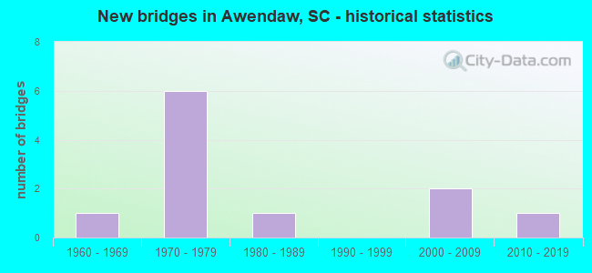
- New bridges - historical statistics
- 11960-1969
- 61970-1979
- 11980-1989
- 22000-2009
- 12010-2019


- Bridge Condition - Deck
- 63.6%Good
- 36.4%Satisfactory

- Bridge Condition - Superstructure
- 72.7%Good
- 27.3%Satisfactory

- Bridge Condition - Substructure
- 36.4%Good
- 54.5%Satisfactory
- 9.1%Fair

- Bridge Condition - Channel
- 27.3%Very good
- 54.5%Good
- 9.1%Satisfactory
- 9.1%Fair
Find on map >> Show street view
Structure Number: 3611, Location: 11.9 MI W MCCLELLANVILLE (Lat: 33.065267, Lng: -79.661175), Route carried "on" structure: State highway 1032, Year Built: 2009, Status: Open, Structure Length: 1.83m (6.00ft), Average Daily Traffic: 1,250 (year 2020), Truck Traffic: 15%, Average Future Daily Traffic: 1,825 (year 2040), Design Load: HL 93, Features Intersected: STREAM
Minimum Vertical Clearance: 30+ m (98+ ft), Kilometerpoint: 2.353, Lanes on structure: 2, Owner: State Highway Agency, Approaching Roadway Width: 7.4m (24.3ft), Material/Design: Prestressed concrete, Design/Construction: Box Beam or Girders - Multiple, Number Of Spans In Main Unit: 1, Length of Maximum Span: 18.3m (60.0ft), Curb-To-Curb Width: 11.0m (36.1ft), Out-to-Out Width: 11.9m (39.0ft)
Condition: Deck: Good, Superstructure: Good, Substructure: Good, Channel: Very good, Operating Rating: 59.3 metric tons, Method Used To Determine Operating Rating: Load and Resistance Factor Rating (LRFR) rating reported by rating factor(RF) method using HL-93 loadings, Inventory Rating: 39.9 metric tons, Method Used To Determine Inventory Rating: Load and Resistance Factor Rating (LRFR) rating reported by rating factor(RF) method using HL-93 loadings, Structural Evaluation: Better than present minimum criteria, Deck Geometry: Equal to present minimum criteria, Waterway Adequacy: Superior to present desirable criteria, Approach Roadway Alignment: Equal to present desirable criteria, Length Of Structure Improvement: 1.83m (6.00ft), Designated Inspection Frequency: Every 24 months, Inspection Date: July 2021, Deck Structure Type: Concrete Precast Panels, Wearing Surface/Protective System: Wearing Surface: Bituminous
Find on map >> Show street view
Structure Number: 3612, Location: 10.8 MI SW MCCLELLANVILLE (Lat: 33.038728, Lng: -79.633308), Route carried "on" structure: State highway 1032, Year Built: 2009, Status: Open, Structure Length: 3.05m (10.01ft), Average Daily Traffic: 1,250 (year 2020), Truck Traffic: 15%, Average Future Daily Traffic: 1,825 (year 2040), Design Load: HL 93, Features Intersected: STEED CREEK
Minimum Vertical Clearance: 30+ m (98+ ft), Kilometerpoint: 5.924, Lanes on structure: 2, Owner: State Highway Agency, Approaching Roadway Width: 7.3m (24.0ft), Material/Design: Prestressed concrete, Design/Construction: Box Beam or Girders - Multiple, Number Of Spans In Main Unit: 1, Number Of Approach Spans: 2, Length of Maximum Span: 12.2m (40.0ft), Curb-To-Curb Width: 11.0m (36.1ft), Out-to-Out Width: 11.9m (39.0ft)
Condition: Deck: Good, Superstructure: Good, Substructure: Good, Channel: Very good, Operating Rating: 45.7 metric tons, Method Used To Determine Operating Rating: Load and Resistance Factor Rating (LRFR) rating reported by rating factor(RF) method using HL-93 loadings, Inventory Rating: 35.3 metric tons, Method Used To Determine Inventory Rating: Load and Resistance Factor Rating (LRFR) rating reported by rating factor(RF) method using HL-93 loadings, Structural Evaluation: Better than present minimum criteria, Deck Geometry: Equal to present minimum criteria, Waterway Adequacy: Superior to present desirable criteria, Approach Roadway Alignment: Equal to present desirable criteria, Length Of Structure Improvement: 3.05m (10.01ft), Designated Inspection Frequency: Every 24 months, Inspection Date: July 2021, Deck Structure Type: Concrete Precast Panels, Wearing Surface/Protective System: Wearing Surface: Bituminous
Find on map >> Show street view
Structure Number: 5236, Location: 16.3 MI E CHAS (Lat: 32.945314, Lng: -79.725650), Route carried "on" structure: State highway 98, Year Built: 2011, Status: Open, Structure Length: 4.57m (14.99ft), Average Daily Traffic: 325 (year 2020), Truck Traffic: 5%, Average Future Daily Traffic: 416 (year 2040), Design Load: HL 93, Features Intersected: WANDO RIVER
Minimum Vertical Clearance: 30+ m (98+ ft), Kilometerpoint: 1.819, Lanes on structure: 2, Owner: State Highway Agency, Approaching Roadway Width: 7.2m (23.6ft), Material/Design: Prestressed concrete, Design/Construction: Slab, Number Of Spans In Main Unit: 3, Length of Maximum Span: 15.2m (49.9ft), Curb-To-Curb Width: 10.1m (33.1ft), Out-to-Out Width: 11.0m (36.1ft)
Condition: Deck: Good, Superstructure: Good, Substructure: Good, Channel: Very good, Operating Rating: 49.9 metric tons, Method Used To Determine Operating Rating: Load and Resistance Factor Rating (LRFR) rating reported by rating factor(RF) method using HL-93 loadings, Inventory Rating: 30.1 metric tons, Method Used To Determine Inventory Rating: Load and Resistance Factor Rating (LRFR) rating reported by rating factor(RF) method using HL-93 loadings, Structural Evaluation: Better than present minimum criteria, Deck Geometry: Better than present minimum criteria, Waterway Adequacy: Superior to present desirable criteria, Approach Roadway Alignment: Equal to present desirable criteria, Length Of Structure Improvement: 4.57m (14.99ft), Designated Inspection Frequency: Every 24 months, Inspection Date: July 2021, Deck Structure Type: Concrete Precast Panels, Wearing Surface/Protective System: Wearing Surface: Bituminous
Find on map >> Show street view
Structure Number: 5677, Location: AT AWENDAW (Lat: 33.030414, Lng: -79.625339), Route carried "on" structure: US 17, Year Built: 1970, Status: Open, Structure Length: 4.57m (14.99ft), Average Daily Traffic: 5,500 (year 2020), Truck Traffic: 10%, Average Future Daily Traffic: 9,570 (year 2040), Design Load: HS 20, Features Intersected: AWENDAW CREEK
Minimum Vertical Clearance: 30+ m (98+ ft), Kilometerpoint: 93.105, Lanes on structure: 2, Base Highway Network: Yes, Owner: State Highway Agency, Approaching Roadway Width: 8.8m (28.9ft), Material/Design: Concrete, Design/Construction: Slab, Number Of Spans In Main Unit: 6, Length of Maximum Span: 7.6m (24.9ft), Curb-To-Curb Width: 11.0m (36.1ft), Out-to-Out Width: 12.8m (42.0ft)
Condition: Deck: Satisfactory, Superstructure: Satisfactory, Substructure: Fair, Channel: Fair, Operating Rating: 39.2 metric tons, Method Used To Determine Operating Rating: Load and Resistance Factor Rating (LRFR) rating reported by rating factor(RF) method using HL-93 loadings, Inventory Rating: 30.1 metric tons, Method Used To Determine Inventory Rating: Load and Resistance Factor Rating (LRFR) rating reported by rating factor(RF) method using HL-93 loadings, Structural Evaluation: Somewhat better than minimum adequacy, Deck Geometry: Equal to present minimum criteria, Waterway Adequacy: Equal to present minimum criteria, Approach Roadway Alignment: Equal to present desirable criteria, Length Of Structure Improvement: 4.57m (14.99ft), Designated Inspection Frequency: Every 24 months, Underwater Inspection Frequency: Every 60 months, Inspection Date: June 2020, Underwater Inspection Date: August 2021, Deck Structure Type: Concrete Cast-file-Place, Wearing Surface/Protective System: Wearing Surface: Bituminous
Find on map >> Show street view
Structure Number: 6031, Location: 4.5MI NE LOWNDESVILLE (Lat: 34.235831, Lng: -82.577939), Route carried "on" structure: State highway 96, Year Built: 1972, Status: Open, Structure Length: 2.74m (8.99ft), Average Daily Traffic: 175 (year 2021), Truck Traffic: 5%, Average Future Daily Traffic: 224 (year 2041), Design Load: H 15, Features Intersected: GILL CREEK
Minimum Vertical Clearance: 30+ m (98+ ft), Kilometerpoint: 5.488, Lanes on structure: 2, Owner: State Highway Agency, Approaching Roadway Width: 6.1m (20.0ft), Material/Design: Prestressed concrete, Design/Construction: Stringer/Multi-beam, Number Of Spans In Main Unit: 3, Length of Maximum Span: 9.1m (29.9ft), Curb-To-Curb Width: 9.9m (32.5ft), Out-to-Out Width: 10.3m (33.8ft)
Condition: Deck: Satisfactory, Superstructure: Satisfactory, Substructure: Satisfactory, Channel: Good, Operating Rating: 19.1 metric tons, Method Used To Determine Operating Rating: Load and Resistance Factor Rating (LRFR) rating reported by rating factor(RF) method using HL-93 loadings, Inventory Rating: 14.3 metric tons, Method Used To Determine Inventory Rating: Load and Resistance Factor Rating (LRFR) rating reported by rating factor(RF) method using HL-93 loadings, Structural Evaluation: Meets minimum limits, Deck Geometry: Better than present minimum criteria, Waterway Adequacy: Superior to present desirable criteria, Approach Roadway Alignment: Equal to present desirable criteria, Bridge Posting: Required (Relationship of Operating Rating to Maximum Legal Load: 30.0 - 39.9% below), Length Of Structure Improvement: 2.74m (8.99ft), Designated Inspection Frequency: Every 24 months, Inspection Date: October 2020, Deck Structure Type: Concrete Cast-file-Place, Wearing Surface/Protective System: Wearing Surface: Monolithic Concrete
Find on map >> Show street view
Structure Number: 6435, Location: 9.8 MI SW MCCLELLANVILLE (Lat: 33.023275, Lng: -79.607408), Route carried "on" structure: State highway 432, Year Built: 1974, Status: Open, Structure Length: 0.91m (2.99ft), Average Daily Traffic: 350 (year 2020), Truck Traffic: 7%, Average Future Daily Traffic: 486 (year 2040), Design Load: H 15, Features Intersected: ALLIGATOR BRANCH
Minimum Vertical Clearance: 30+ m (98+ ft), Kilometerpoint: 2.150, Lanes on structure: 2, Owner: State Highway Agency, Approaching Roadway Width: 6.1m (20.0ft), Material/Design: Concrete, Design/Construction: Slab, Number Of Spans In Main Unit: 2, Length of Maximum Span: 4.6m (15.1ft), Curb-To-Curb Width: 9.6m (31.5ft), Out-to-Out Width: 10.1m (33.1ft)
Condition: Deck: Good, Superstructure: Good, Substructure: Good, Channel: Good, Operating Rating: 31.4 metric tons, Method Used To Determine Operating Rating: Load and Resistance Factor Rating (LRFR) rating reported by rating factor(RF) method using HL-93 loadings, Inventory Rating: 24.3 metric tons, Method Used To Determine Inventory Rating: Load and Resistance Factor Rating (LRFR) rating reported by rating factor(RF) method using HL-93 loadings, Structural Evaluation: Equal to present minimum criteria, Deck Geometry: Equal to present minimum criteria, Waterway Adequacy: Better than present minimum criteria, Approach Roadway Alignment: Equal to present desirable criteria, Length Of Structure Improvement: 0.91m (2.99ft), Designated Inspection Frequency: Every 24 months, Inspection Date: June 2021, Deck Structure Type: Concrete Precast Panels, Wearing Surface/Protective System: Wearing Surface: Bituminous
Find on map >> Show street view
Structure Number: 6961, Location: AT AWENDAW (Lat: 33.030281, Lng: -79.625164), Route carried "on" structure: US 17, Year Built: 1977, Status: Open, Structure Length: 4.27m (14.01ft), Average Daily Traffic: 5,500 (year 2020), Truck Traffic: 10%, Average Future Daily Traffic: 9,570 (year 2040), Design Load: HS 20, Features Intersected: AWENDAW CREEK
Minimum Vertical Clearance: 30+ m (98+ ft), Kilometerpoint: 93.105, Lanes on structure: 2, Base Highway Network: Yes, Owner: State Highway Agency, Approaching Roadway Width: 8.2m (26.9ft), Material/Design: Concrete, Design/Construction: Slab, Number Of Spans In Main Unit: 5, Length of Maximum Span: 9.1m (29.9ft), Curb-To-Curb Width: 12.0m (39.4ft), Out-to-Out Width: 13.1m (43.0ft)
Condition: Deck: Satisfactory, Superstructure: Satisfactory, Substructure: Satisfactory, Channel: Good, Operating Rating: 37.9 metric tons, Method Used To Determine Operating Rating: Load and Resistance Factor Rating (LRFR) rating reported by rating factor(RF) method using HL-93 loadings, Inventory Rating: 29.2 metric tons, Method Used To Determine Inventory Rating: Load and Resistance Factor Rating (LRFR) rating reported by rating factor(RF) method using HL-93 loadings, Structural Evaluation: Equal to present minimum criteria, Deck Geometry: Better than present minimum criteria, Waterway Adequacy: Equal to present minimum criteria, Approach Roadway Alignment: Equal to present desirable criteria, Length Of Structure Improvement: 4.27m (14.01ft), Designated Inspection Frequency: Every 24 months, Underwater Inspection Frequency: Every 60 months, Inspection Date: June 2020, Underwater Inspection Date: August 2021, Deck Structure Type: Concrete Cast-file-Place, Wearing Surface/Protective System: Wearing Surface: Bituminous
Find on map >> Show street view
Structure Number: 81205000003141, Location: NO DATA ENTERED (Lat: 33.035011, Lng: -79.673625), Route carried "on" structure: Federal lands road 202.3, Year Built: 1965, Status: Posted for load, Structure Length: 1.84m (6.04ft), Average Daily Traffic: 50 (year 0000), Average Future Daily Traffic: 75 (year 2042), Design Load: H 20, Features Intersected: CREEK, Facility Carried by Structure: COOTER CREEK-Bridg
Minimum Vertical Clearance: 30+ m (98+ ft), Kilometerpoint: 4.960, Lanes on structure: 2, Owner: U.S. Forest Service, Approaching Roadway Width: 7.3m (24.0ft), Material/Design: Prestressed concrete, Design/Construction: Channel Beam, Number Of Spans In Main Unit: 3, Length of Maximum Span: 6.1m (20.0ft), Curb or Sidewalk Widths: Left: 0.3m (1.0ft), Right: 0.3m (1.0ft), Curb-To-Curb Width: 7.1m (23.3ft), Out-to-Out Width: 7.6m (24.9ft)
Condition: Deck: Good, Superstructure: Good, Substructure: Satisfactory, Channel: Satisfactory, Operating Rating: 19.1 metric tons, Method Used To Determine Operating Rating: Load and Resistance Factor Rating (LRFR) rating reported by rating factor(RF) method using HL-93 loadings, Inventory Rating: 12.0 metric tons, Method Used To Determine Inventory Rating: Load and Resistance Factor Rating (LRFR) rating reported by rating factor(RF) method using HL-93 loadings, Structural Evaluation: Meets minimum limits, Deck Geometry: Somewhat better than minimum adequacy, Waterway Adequacy: Somewhat better than minimum adequacy, Approach Roadway Alignment: Equal to present desirable criteria, Bridge Posting: Required (Relationship of Operating Rating to Maximum Legal Load: 0.1 - 9.9% below), Designated Inspection Frequency: Every 24 months, Inspection Date: March 2021, Deck Structure Type: Concrete Cast-file-Place, Wearing Surface/Protective System: Wearing Surface: Other
Find on map >> Show street view
Structure Number: 81205000003145, Location: NO DATA ENTERED (Lat: 33.042150, Lng: -79.673531), Route carried "on" structure: Federal lands road 224, Year Built: 1988, Status: Open, Structure Length: 0.94m (3.08ft), Average Daily Traffic: 50 (year 0000), Average Future Daily Traffic: 75 (year 2042), Design Load: HS 20, Features Intersected: BRANCH, Facility Carried by Structure: BR. OF COOTER CREE
Minimum Vertical Clearance: 30+ m (98+ ft), Kilometerpoint: 0.800, Lanes on structure: 1, Owner: U.S. Forest Service, Approaching Roadway Width: 4.3m (14.1ft), Material/Design: Prestressed concrete, Design/Construction: Box Beam or Girders - Multiple, Number Of Spans In Main Unit: 1, Length of Maximum Span: 8.8m (28.9ft), Curb or Sidewalk Widths: Left: 0.3m (1.0ft), Right: 0.3m (1.0ft), Curb-To-Curb Width: 4.8m (15.7ft), Out-to-Out Width: 5.7m (18.7ft)
Condition: Deck: Good, Superstructure: Good, Substructure: Satisfactory, Channel: Good, Deck Geometry: Equal to present desirable criteria, Waterway Adequacy: Equal to present desirable criteria, Approach Roadway Alignment: Equal to present desirable criteria, Designated Inspection Frequency: Every 24 months, Inspection Date: March 2021, Deck Structure Type: Concrete Precast Panels, Wearing Surface/Protective System: Wearing Surface: Other
Find on map >> Show street view
Structure Number: 81205000003146, Location: NO DATA ENTERED (Lat: 33.007839, Lng: -79.684581), Route carried "on" structure: Federal lands road 228.1, Year Built: 1979, Status: Open, Structure Length: 0.91m (2.99ft), Average Daily Traffic: 50 (year 0000), Average Future Daily Traffic: 75 (year 2042), Design Load: HS 20, Features Intersected: CREEK, Facility Carried by Structure: IRON SWAMP-Bridge
Minimum Vertical Clearance: 30+ m (98+ ft), Kilometerpoint: 1.760, Lanes on structure: 1, Owner: U.S. Forest Service, Approaching Roadway Width: 4.3m (14.1ft), Material/Design: Prestressed concrete, Design/Construction: Channel Beam, Number Of Spans In Main Unit: 1, Length of Maximum Span: 8.7m (28.5ft), Curb or Sidewalk Widths: Left: 0.3m (1.0ft), Right: 0.3m (1.0ft), Curb-To-Curb Width: 4.3m (14.1ft), Out-to-Out Width: 4.7m (15.4ft)
Condition: Deck: Satisfactory, Superstructure: Good, Substructure: Satisfactory, Channel: Good, Operating Rating: 26.2 metric tons, Method Used To Determine Operating Rating: Load and Resistance Factor Rating (LRFR) rating reported by rating factor(RF) method using HL-93 loadings, Inventory Rating: 20.1 metric tons, Method Used To Determine Inventory Rating: Load and Resistance Factor Rating (LRFR) rating reported by rating factor(RF) method using HL-93 loadings, Structural Evaluation: Somewhat better than minimum adequacy, Deck Geometry: Equal to present minimum criteria, Waterway Adequacy: Meets minimum limits, Approach Roadway Alignment: Equal to present desirable criteria, Designated Inspection Frequency: Every 24 months, Inspection Date: March 2021, Deck Structure Type: Concrete Precast Panels, Wearing Surface/Protective System: Wearing Surface: Other
Find on map >> Show street view
Structure Number: 81205000003147, Location: NO DATA ENTERED (Lat: 32.988661, Lng: -79.674569), Route carried "on" structure: Federal lands road 228.2, Year Built: 1979, Status: Open, Structure Length: 0.92m (3.02ft), Average Daily Traffic: 50 (year 0000), Average Future Daily Traffic: 75 (year 2042), Design Load: H 20, Features Intersected: CANAL, Facility Carried by Structure: WYTHEWOOD CANAL-Br
Minimum Vertical Clearance: 30+ m (98+ ft), Kilometerpoint: 4.320, Lanes on structure: 1, Owner: U.S. Forest Service, Approaching Roadway Width: 4.3m (14.1ft), Material/Design: Prestressed concrete, Design/Construction: Channel Beam, Number Of Spans In Main Unit: 1, Length of Maximum Span: 8.7m (28.5ft), Curb or Sidewalk Widths: Left: 0.3m (1.0ft), Right: 0.3m (1.0ft), Curb-To-Curb Width: 4.3m (14.1ft), Out-to-Out Width: 4.7m (15.4ft)
Condition: Deck: Good, Superstructure: Good, Substructure: Satisfactory, Channel: Good, Operating Rating: 39.2 metric tons, Method Used To Determine Operating Rating: Load and Resistance Factor Rating (LRFR) rating reported by rating factor(RF) method using HL-93 loadings, Inventory Rating: 30.1 metric tons, Method Used To Determine Inventory Rating: Load and Resistance Factor Rating (LRFR) rating reported by rating factor(RF) method using HL-93 loadings, Structural Evaluation: Equal to present minimum criteria, Deck Geometry: Equal to present minimum criteria, Waterway Adequacy: Somewhat better than minimum adequacy, Approach Roadway Alignment: Equal to present desirable criteria, Designated Inspection Frequency: Every 24 months, Inspection Date: March 2021, Deck Structure Type: Concrete Precast Panels, Wearing Surface/Protective System: Wearing Surface: Other