Bridge Statistics for Azalea Park, Florida (FL)
Condition, Traffic, Stress, Structural Evaluation, Project Costs
- National Bridge Inventory (NBI) Statistics
- 20Number of bridges
- 226ft / 68.8mTotal length
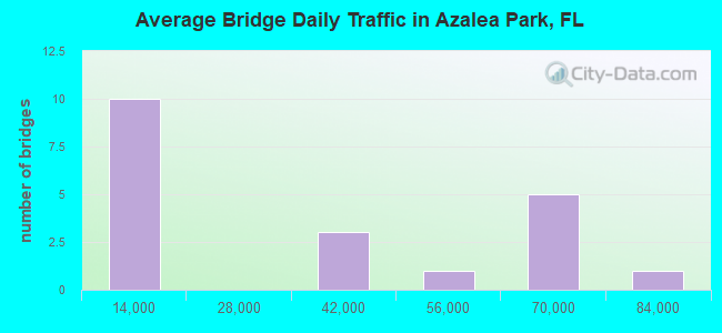
- 621,310Total average daily traffic
- 29,595Total average daily truck traffic
- National Bridge Inventory (NBI) Registered Bridges for Azalea Park
- No street view available for this location
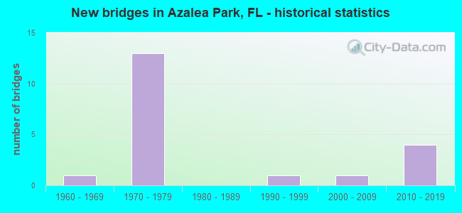
- New bridges - historical statistics
- 11960-1969
- 131970-1979
- 11990-1999
- 12000-2009
- 42010-2019
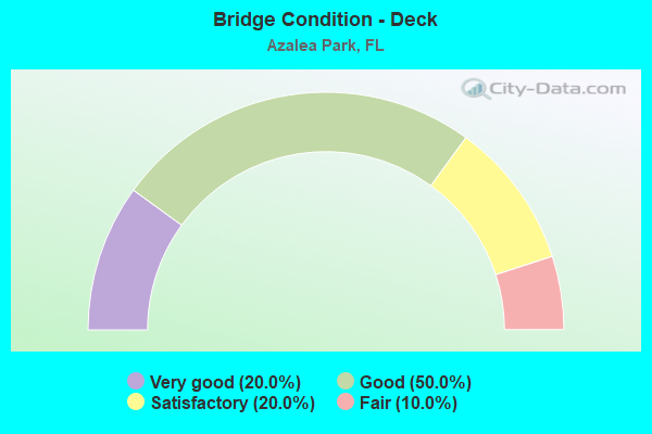
- Bridge Condition - Deck
- 20.0%Very good
- 50.0%Good
- 20.0%Satisfactory
- 10.0%Fair
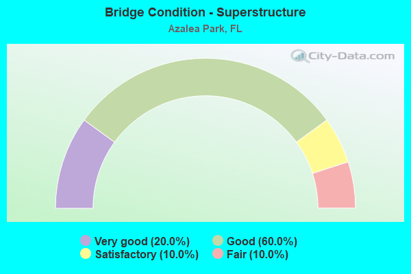
- Bridge Condition - Superstructure
- 20.0%Very good
- 60.0%Good
- 10.0%Satisfactory
- 10.0%Fair
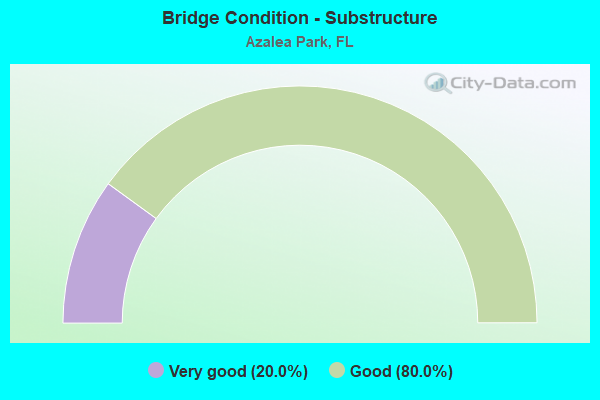
- Bridge Condition - Substructure
- 20.0%Very good
- 80.0%Good
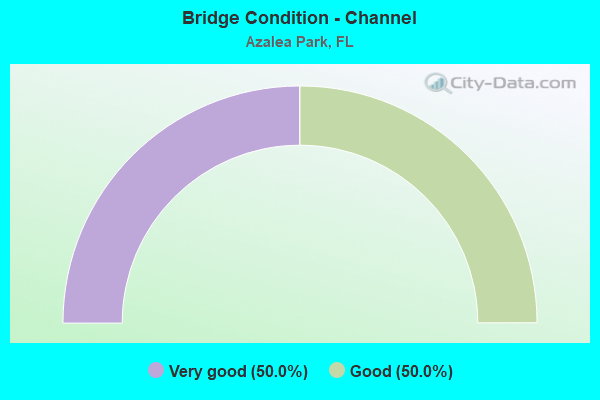
- Bridge Condition - Channel
- 50.0%Very good
- 50.0%Good
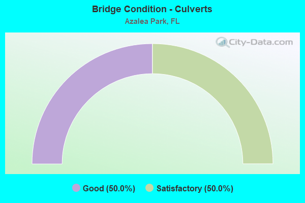
- Bridge Condition - Culverts
- 50.0%Good
- 50.0%Satisfactory
Find on map >> Show street view
Structure Number: 750126, Location: 0.3 Mi E of Semoran Blvd (Lat: 28.539667, Lng: -81.306000), Route carried "on" structure: State highway 408, Year Built: 1973, Status: Open, Structure Length: 3.89m (12.76ft), Average Daily Traffic: 69,750 (year 2020), Truck Traffic: 4%, Average Future Daily Traffic: 121,016 (year 2042), Design Load: HS 20, Features Intersected: Yucatan Drive
Minimum Vertical Clearance: 30+ m (98+ ft), Kilometerpoint: 15.933, Lanes on structure: 5, Lanes under structure: 3, Base Highway Network: Yes, Toll: On toll road, Owner: State Toll Authority, Approaching Roadway Width: 24.4m (80.1ft), Skew: 1 degrees, Material/Design: Prestressed concrete, Design/Construction: Stringer/Multi-beam, Number Of Spans In Main Unit: 3, Length of Maximum Span: 18.6m (61.0ft), Curb-To-Curb Width: 24.4m (80.1ft), Out-to-Out Width: 25.3m (83.0ft)
Condition: Deck: Good, Superstructure: Good, Substructure: Good, Operating Rating: 53.9 metric tons, Method Used To Determine Operating Rating: Load Factor (LF), Inventory Rating: 32.4 metric tons, Method Used To Determine Inventory Rating: Load Factor (LF), Structural Evaluation: Better than present minimum criteria, Deck Geometry: Equal to present minimum criteria, Underclear: Meets minimum limits, Approach Roadway Alignment: Equal to present desirable criteria, Designated Inspection Frequency: Every 24 months, Inspection Date: March 2021, Deck Structure Type: Concrete Cast-file-Place
Find on map >> Show street view
Structure Number: 750129, Location: SR-408 WB - SR-551 (Lat: 28.540664, Lng: -81.285814), Route carried "on" structure: State highway 408, Year Built: 1973, Year Reconstructed: 2011, Status: Open, Structure Length: 6.13m (20.11ft), Average Daily Traffic: 69,750 (year 2020), Truck Traffic: 4%, Average Future Daily Traffic: 121,016 (year 2042), Design Load: HL 93, Features Intersected: SR-551
Minimum Vertical Clearance: 30+ m (98+ ft), Kilometerpoint: 17.915, Lanes on structure: 5, Lanes under structure: 7, Base Highway Network: Yes, Toll: On toll road, Owner: State Toll Authority, Approaching Roadway Width: 24.9m (81.7ft), Skew: 2 degrees, Material/Design: Prestressed concrete, Design/Construction: Stringer/Multi-beam, Number Of Spans In Main Unit: 4, Length of Maximum Span: 19.2m (63.0ft), Curb-To-Curb Width: 24.9m (81.7ft), Out-to-Out Width: 25.8m (84.6ft)
Condition: Deck: Satisfactory, Superstructure: Good, Substructure: Good, Operating Rating: 45.1 metric tons, Method Used To Determine Operating Rating: Load and Resistance Factor (LRFR), Inventory Rating: 36.3 metric tons, Method Used To Determine Inventory Rating: Load and Resistance Factor (LRFR), Structural Evaluation: Better than present minimum criteria, Deck Geometry: Better than present minimum criteria, Underclear: High priority of corrective action, Approach Roadway Alignment: Equal to present desirable criteria, Designated Inspection Frequency: Every 24 months, Inspection Date: March 2020, Deck Structure Type: Concrete Cast-file-Place
Find on map >> Show street view
Structure Number: 750185, Location: 0.3 Mi E of Semoran Blvd. (Lat: 28.539400, Lng: -81.306000), Route carried "on" structure: State highway 408, Year Built: 1973, Year Reconstructed: 2009, Status: Open, Structure Length: 3.75m (12.30ft), Average Daily Traffic: 69,750 (year 2020), Truck Traffic: 4%, Average Future Daily Traffic: 121,016 (year 2042), Design Load: HS 20, Features Intersected: Yucatan Drive
Minimum Vertical Clearance: 30+ m (98+ ft), Kilometerpoint: 15.933, Lanes on structure: 4, Lanes under structure: 3, Base Highway Network: Yes, Toll: On toll road, Owner: State Toll Authority, Approaching Roadway Width: 20.4m (66.9ft), Material/Design: Prestressed concrete, Design/Construction: Stringer/Multi-beam, Number Of Spans In Main Unit: 3, Length of Maximum Span: 17.5m (57.4ft), Curb-To-Curb Width: 20.4m (66.9ft), Out-to-Out Width: 21.3m (69.9ft)
Condition: Deck: Good, Superstructure: Good, Substructure: Good, Operating Rating: 49.4 metric tons, Method Used To Determine Operating Rating: Load Factor (LF), Inventory Rating: 37.8 metric tons, Method Used To Determine Inventory Rating: Load Factor (LF), Structural Evaluation: Better than present minimum criteria, Deck Geometry: Equal to present minimum criteria, Underclear: Meets minimum limits, Approach Roadway Alignment: Equal to present desirable criteria, Designated Inspection Frequency: Every 24 months, Inspection Date: March 2021, Deck Structure Type: Concrete Cast-file-Place
Find on map >> Show street view
Structure Number: 750251, Location: SR-408WB - Oxalis Drive (Lat: 28.539614, Lng: -81.300381), Route carried "on" structure: State highway 408, Year Built: 1973, Year Reconstructed: 2009, Status: Open, Structure Length: 3.84m (12.60ft), Average Daily Traffic: 73,250 (year 2021), Truck Traffic: 5%, Average Future Daily Traffic: 127,089 (year 2042), Design Load: HS 20, Features Intersected: Oxalis Drive
Minimum Vertical Clearance: 30+ m (98+ ft), Kilometerpoint: 16.483, Lanes on structure: 4, Lanes under structure: 2, Base Highway Network: Yes, Toll: On toll road, Owner: State Toll Authority, Approaching Roadway Width: 20.6m (67.6ft), Material/Design: Prestressed concrete, Design/Construction: Stringer/Multi-beam, Number Of Spans In Main Unit: 3, Length of Maximum Span: 17.5m (57.4ft), Curb-To-Curb Width: 20.6m (67.6ft), Out-to-Out Width: 21.5m (70.5ft)
Condition: Deck: Good, Superstructure: Good, Substructure: Good, Operating Rating: 55.5 metric tons, Method Used To Determine Operating Rating: Load Factor (LF), Inventory Rating: 33.3 metric tons, Method Used To Determine Inventory Rating: Load Factor (LF), Structural Evaluation: Better than present minimum criteria, Deck Geometry: Equal to present minimum criteria, Underclear: Meets minimum limits, Approach Roadway Alignment: Equal to present desirable criteria, Designated Inspection Frequency: Every 24 months, Inspection Date: April 2021, Deck Structure Type: Concrete Cast-file-Place
Find on map >> Show street view
Structure Number: 750252, Location: SR-408 EB - Oxalis Drive (Lat: 28.539439, Lng: -81.300367), Route carried "on" structure: State highway 408, Year Built: 1973, Year Reconstructed: 2009, Status: Open, Structure Length: 3.84m (12.60ft), Average Daily Traffic: 69,750 (year 2020), Truck Traffic: 4%, Average Future Daily Traffic: 121,016 (year 2042), Design Load: HS 20, Features Intersected: Oxalis Drive
Minimum Vertical Clearance: 30+ m (98+ ft), Kilometerpoint: 16.483, Lanes on structure: 5, Lanes under structure: 3, Base Highway Network: Yes, Toll: On toll road, Owner: State Toll Authority, Approaching Roadway Width: 24.1m (79.1ft), Material/Design: Prestressed concrete, Design/Construction: Stringer/Multi-beam, Number Of Spans In Main Unit: 3, Length of Maximum Span: 17.4m (57.1ft), Curb-To-Curb Width: 24.1m (79.1ft), Out-to-Out Width: 25.1m (82.3ft)
Condition: Deck: Good, Superstructure: Good, Substructure: Good, Operating Rating: 55.5 metric tons, Method Used To Determine Operating Rating: Load Factor (LF), Inventory Rating: 33.3 metric tons, Method Used To Determine Inventory Rating: Load Factor (LF), Structural Evaluation: Better than present minimum criteria, Deck Geometry: Equal to present minimum criteria, Underclear: Meets minimum limits, Approach Roadway Alignment: Equal to present desirable criteria, Designated Inspection Frequency: Every 24 months, Inspection Date: April 2021, Deck Structure Type: Concrete Cast-file-Place
Find on map >> Show street view
Structure Number: 750253, Location: SR-408 EB - SR-551 (Lat: 28.540503, Lng: -81.285825), Route carried "on" structure: State highway 408, Year Built: 1973, Year Reconstructed: 2011, Status: Open, Structure Length: 6.13m (20.11ft), Average Daily Traffic: 69,750 (year 2020), Truck Traffic: 4%, Average Future Daily Traffic: 121,016 (year 2042), Design Load: HL 93, Features Intersected: SR-551
Minimum Vertical Clearance: 30+ m (98+ ft), Kilometerpoint: 17.915, Lanes on structure: 5, Lanes under structure: 7, Base Highway Network: Yes, Toll: On toll road, Owner: State Toll Authority, Approaching Roadway Width: 28.7m (94.2ft), Skew: 2 degrees, Material/Design: Prestressed concrete, Design/Construction: Stringer/Multi-beam, Number Of Spans In Main Unit: 4, Length of Maximum Span: 19.2m (63.0ft), Curb-To-Curb Width: 28.7m (94.2ft), Out-to-Out Width: 29.8m (97.8ft)
Condition: Deck: Satisfactory, Superstructure: Good, Substructure: Good, Operating Rating: 45.4 metric tons, Method Used To Determine Operating Rating: Load and Resistance Factor (LRFR), Inventory Rating: 36.6 metric tons, Method Used To Determine Inventory Rating: Load and Resistance Factor (LRFR), Structural Evaluation: Better than present minimum criteria, Deck Geometry: Superior to present desirable criteria, Underclear: High priority of corrective action, Approach Roadway Alignment: Equal to present desirable criteria, Designated Inspection Frequency: Every 24 months, Inspection Date: March 2020, Deck Structure Type: Concrete Cast-file-Place
Find on map >> Show street view
Structure Number: 750482, Location: 0.7 MI. S of SR-50 (Lat: 28.557144, Lng: -81.285997), Route carried "on" structure: State highway 551, Year Built: 1997, Status: Open, Structure Length: 0.95m (3.12ft), Average Daily Traffic: 34,500 (year 2020), Truck Traffic: 6%, Average Future Daily Traffic: 59,858 (year 2042), Design Load: HS 20+Mod, Features Intersected: Unnamed Canal
Minimum Vertical Clearance: 30+ m (98+ ft), Kilometerpoint: 9.107, Lanes on structure: 5, Owner: State Highway Agency, Approaching Roadway Width: 21.2m (69.6ft), Material/Design: Concrete, Design/Construction: Culvert, Number Of Spans In Main Unit: 3, Length of Maximum Span: 3.0m (9.8ft)
Condition: Channel: Very good, Culverts: Satisfactory, Inventory Rating: 58.1 metric tons, Method Used To Determine Inventory Rating: Load Factor (LF), Structural Evaluation: Equal to present minimum criteria, Waterway Adequacy: Equal to present desirable criteria, Approach Roadway Alignment: Equal to present desirable criteria, Designated Inspection Frequency: Every 24 months, Inspection Date: June 2021
Find on map >> Show street view
Structure Number: 750562, Location: 0.3 Mi East of SR-15A (Lat: 28.568331, Lng: -81.280531), Route carried "on" structure: State highway 50, Year Built: 2009, Status: Open, Structure Length: 0.88m (2.89ft), Average Daily Traffic: 51,000 (year 2020), Truck Traffic: 5%, Average Future Daily Traffic: 88,485 (year 2042), Design Load: HL 93, Features Intersected: Outfall
Minimum Vertical Clearance: 30+ m (98+ ft), Kilometerpoint: 11.721, Lanes on structure: 7, Owner: State Highway Agency, Approaching Roadway Width: 24.5m (80.4ft), Skew: 29 degrees, Material/Design: Concrete, Design/Construction: Culvert, Number Of Spans In Main Unit: 2, Length of Maximum Span: 4.3m (14.1ft)
Condition: Channel: Good, Culverts: Good, Operating Rating: 58.8 metric tons, Method Used To Determine Operating Rating: Load and Resistance Factor (LRFR), Inventory Rating: 45.4 metric tons, Method Used To Determine Inventory Rating: Load and Resistance Factor (LRFR), Structural Evaluation: Better than present minimum criteria, Waterway Adequacy: Equal to present desirable criteria, Approach Roadway Alignment: Equal to present desirable criteria, Designated Inspection Frequency: Every 24 months, Inspection Date: December 2021
Find on map >> Show street view
Structure Number: 750741, Location: 0.3 Mi W of Chickasaw Trl (Lat: 28.542444, Lng: -81.282333), Route carried "on" structure: Ramp State highway 408, Year Built: 2012, Status: Open, Structure Length: 17.12m (56.17ft), Average Daily Traffic: 6,600 (year 2020), Truck Traffic: 6%, Average Future Daily Traffic: 11,451 (year 2042), Design Load: HL 93, Features Intersected: SR-408 WB Off-Ramp
Minimum Vertical Clearance: 30+ m (98+ ft), Kilometerpoint: 0.401, Lanes on structure: 1, Lanes under structure: 2, Base Highway Network: Yes, Toll: On toll road, Owner: State Toll Authority, Approaching Roadway Width: 8.2m (26.9ft), Material/Design: Prestressed concrete, Design/Construction: Box Beam or Girders - Single/Spread, Number Of Spans In Main Unit: 5, Length of Maximum Span: 34.2m (112.2ft), Curb-To-Curb Width: 8.2m (26.9ft), Out-to-Out Width: 9.2m (30.2ft)
Condition: Deck: Very good, Superstructure: Very good, Substructure: Very good, Operating Rating: 38.8 metric tons, Method Used To Determine Operating Rating: Load and Resistance Factor (LRFR), Inventory Rating: 34.3 metric tons, Method Used To Determine Inventory Rating: Load and Resistance Factor (LRFR), Structural Evaluation: Equal to present desirable criteria, Deck Geometry: Superior to present desirable criteria, Underclear: Somewhat better than minimum adequacy, Approach Roadway Alignment: Equal to present desirable criteria, Designated Inspection Frequency: Every 24 months, Inspection Date: January 2021, Deck Structure Type: Concrete Cast-file-Place
Find on map >> Show street view
Structure Number: 750742, Location: 0.3 Mi W of Chickasaw Trl (Lat: 28.541750, Lng: -81.282500), Route carried "on" structure: Ramp State highway 408, Year Built: 2012, Status: Open, Structure Length: 15.37m (50.43ft), Average Daily Traffic: 6,700 (year 2020), Truck Traffic: 6%, Average Future Daily Traffic: 11,624 (year 2042), Design Load: HL 93, Features Intersected: SR-408 EB On-Ramp
Minimum Vertical Clearance: 30+ m (98+ ft), Kilometerpoint: 0.230, Lanes on structure: 1, Lanes under structure: 1, Toll: On toll road, Owner: State Toll Authority, Approaching Roadway Width: 8.2m (26.9ft), Material/Design: Prestressed concrete, Design/Construction: Box Beam or Girders - Single/Spread, Number Of Spans In Main Unit: 5, Length of Maximum Span: 30.7m (100.7ft), Curb-To-Curb Width: 8.2m (26.9ft), Out-to-Out Width: 9.2m (30.2ft)
Condition: Deck: Very good, Superstructure: Very good, Substructure: Very good, Operating Rating: 39.8 metric tons, Method Used To Determine Operating Rating: Load and Resistance Factor (LRFR), Inventory Rating: 34.9 metric tons, Method Used To Determine Inventory Rating: Load and Resistance Factor (LRFR), Structural Evaluation: Equal to present desirable criteria, Deck Geometry: Superior to present desirable criteria, Underclear: Somewhat better than minimum adequacy, Approach Roadway Alignment: Equal to present desirable criteria, Designated Inspection Frequency: Every 24 months, Inspection Date: January 2021, Deck Structure Type: Concrete Cast-file-Place
Find on map >> Show street view
Structure Number: 754019, Location: 1.3 Miles S of SR-50 (Lat: 28.548333, Lng: -81.294139), Route carried "on" structure: County highway , Year Built: 1975, Status: Open, Structure Length: 3.20m (10.50ft), Average Daily Traffic: 1,422 (year 2021), Truck Traffic: 5%, Average Future Daily Traffic: 1,649 (year 2042), Design Load: HS 20, Features Intersected: E-8 Canal, Facility Carried by Structure: Forsyth Road
Minimum Vertical Clearance: 30+ m (98+ ft), Kilometerpoint: 0.000, Lanes on structure: 2, Owner: County Highway Agency, Approaching Roadway Width: 8.2m (26.9ft), Material/Design: Prestressed concrete, Design/Construction: Slab, Number Of Spans In Main Unit: 3, Length of Maximum Span: 10.7m (35.1ft), Curb or Sidewalk Widths: Left: 1.1m (3.6ft), Right: 1.1m (3.6ft), Curb-To-Curb Width: 9.2m (30.2ft), Out-to-Out Width: 12.2m (40.0ft)
Condition: Deck: Fair, Superstructure: Fair, Substructure: Good, Channel: Good, Operating Rating: 58.2 metric tons, Method Used To Determine Operating Rating: Allowable Stress (AS), Inventory Rating: 47.2 metric tons, Method Used To Determine Inventory Rating: Allowable Stress (AS), Structural Evaluation: Somewhat better than minimum adequacy, Deck Geometry: Somewhat better than minimum adequacy, Waterway Adequacy: Superior to present desirable criteria, Approach Roadway Alignment: Equal to present desirable criteria, Designated Inspection Frequency: Every 24 months, Underwater Inspection Frequency: Every 24 months, Inspection Date: September 2021, Underwater Inspection Date: September 2021, Deck Structure Type: Concrete Precast Panels, Wearing Surface/Protective System: Wearing Surface: Bituminous
Find on map >> Show street view
Structure Number: 754024, Location: 0.4 mi North of SR-50 (Lat: 28.574531, Lng: -81.269611), Route carried "on" structure: County highway , Year Built: 1968, Status: Posted for load, Structure Length: 3.66m (12.01ft), Average Daily Traffic: 4,900 (year 2021), Truck Traffic: 6%, Average Future Daily Traffic: 8,502 (year 2042), Features Intersected: Little Econ River, Facility Carried by Structure: Harrell Road
Minimum Vertical Clearance: 30+ m (98+ ft), Kilometerpoint: 0.665, Lanes on structure: 2, Owner: County Highway Agency, Approaching Roadway Width: 8.2m (26.9ft), Material/Design: Prestressed concrete, Design/Construction: Tee Beam, Number Of Spans In Main Unit: 2, Length of Maximum Span: 18.3m (60.0ft), Curb-To-Curb Width: 8.7m (28.5ft), Out-to-Out Width: 9.8m (32.2ft)
Condition: Deck: Good, Superstructure: Satisfactory, Substructure: Good, Channel: Very good, Operating Rating: 16.7 metric tons, Method Used To Determine Operating Rating: Load and Resistance Factor (LRFR), Inventory Rating: 15.1 metric tons, Method Used To Determine Inventory Rating: Load and Resistance Factor (LRFR), Structural Evaluation: Meets minimum limits, Deck Geometry: Meets minimum limits, Waterway Adequacy: Equal to present desirable criteria, Approach Roadway Alignment: Equal to present desirable criteria, Bridge Posting: Required (Relationship of Operating Rating to Maximum Legal Load: 30.0 - 39.9% below), Designated Inspection Frequency: Every 24 months, Underwater Inspection Frequency: Every 24 months, Other Special Inspection Frequency: Every 12 months, Inspection Date: September 2021, Underwater Inspection Date: September 2021, Other Special Inspection Date: September 2021, Deck Structure Type: Concrete Cast-file-Place
Find on map >> Show street view
Structure Number: 750126, Location: 0.3 Mi E of Semoran Blvd (Lat: 28.539667, Lng: -81.306000), Route carried "under" structure: City street , Year Built: 1973, Structure Length: 0. m, Average Daily Traffic: 1,068 (year 2020), Truck Traffic: 5%, Features Intersected: Yucatan Drive, Facility Carried by Structure: SR-408 WB
Minimum Vertical Clearance: 5.00m (16.40ft), Kilometerpoint: 0.000, Lanes on structure: 5, Lanes under structure: 3, Material/Design: Prestressed concrete, Design/Construction: Stringer/Multi-beam, Length of Maximum Span: 18.6m (61.0ft)
Find on map >> Show street view
Structure Number: 750129, Location: SR-408 WB - SR-551 (Lat: 28.540664, Lng: -81.285814), Route carried "under" structure: State highway 551, Year Built: 1973, Structure Length: 0. m, Average Daily Traffic: 34,000 (year 2020), Truck Traffic: 7%, Features Intersected: SR-551, Facility Carried by Structure: SR-408 WB
Minimum Vertical Clearance: 4.94m (16.21ft), Kilometerpoint: 7.282, Lanes on structure: 5, Lanes under structure: 7, Material/Design: Prestressed concrete, Design/Construction: Stringer/Multi-beam, Length of Maximum Span: 19.2m (63.0ft)
Find on map >> Show street view
Structure Number: 750185, Location: 0.3 Mi E of Semoran Blvd. (Lat: 28.539400, Lng: -81.306000), Route carried "under" structure: City street , Year Built: 1973, Structure Length: 0. m, Average Daily Traffic: 1,068 (year 2020), Truck Traffic: 5%, Features Intersected: Yucatan Drive, Facility Carried by Structure: SR-408 EB
Minimum Vertical Clearance: 4.82m (15.81ft), Kilometerpoint: 0.000, Lanes on structure: 4, Lanes under structure: 3, Material/Design: Prestressed concrete, Design/Construction: Stringer/Multi-beam, Length of Maximum Span: 17.5m (57.4ft)
Find on map >> Show street view
Structure Number: 750251, Location: SR-408WB - Oxalis Drive (Lat: 28.539614, Lng: -81.300381), Route carried "under" structure: City street , Year Built: 1973, Structure Length: 0. m, Average Daily Traffic: 5,376 (year 2019), Truck Traffic: 5%, Features Intersected: Oxalis Drive, Facility Carried by Structure: SR-408 WB
Minimum Vertical Clearance: 4.75m (15.58ft), Kilometerpoint: 0.000, Lanes on structure: 4, Lanes under structure: 2, Material/Design: Prestressed concrete, Design/Construction: Stringer/Multi-beam, Length of Maximum Span: 17.5m (57.4ft)
Find on map >> Show street view
Structure Number: 750252, Location: SR-408 EB - Oxalis Drive (Lat: 28.539439, Lng: -81.300367), Route carried "under" structure: City street , Year Built: 1973, Structure Length: 0. m, Average Daily Traffic: 5,376 (year 2019), Truck Traffic: 5%, Features Intersected: Oxalis Drive, Facility Carried by Structure: SR-408 EB
Minimum Vertical Clearance: 4.94m (16.21ft), Kilometerpoint: 0.000, Lanes on structure: 5, Lanes under structure: 3, Material/Design: Prestressed concrete, Design/Construction: Stringer/Multi-beam, Length of Maximum Span: 17.4m (57.1ft)
Find on map >> Show street view
Structure Number: 750253, Location: SR-408 EB - SR-551 (Lat: 28.540503, Lng: -81.285825), Route carried "under" structure: State highway 551, Year Built: 1973, Structure Length: 0. m, Average Daily Traffic: 34,000 (year 2020), Truck Traffic: 7%, Features Intersected: SR-551, Facility Carried by Structure: SR-408 EB
Minimum Vertical Clearance: 4.94m (16.21ft), Kilometerpoint: 7.248, Lanes on structure: 5, Lanes under structure: 7, Material/Design: Prestressed concrete, Design/Construction: Stringer/Multi-beam, Length of Maximum Span: 19.2m (63.0ft)
Find on map >> Show street view
Structure Number: 750741, Location: 0.3 Mi W of Chickasaw Trl (Lat: 28.542444, Lng: -81.282333), Route carried "under" structure: Ramp Interstate 408, Year Built: 2012, Structure Length: 0. m, Average Daily Traffic: 6,600 (year 2020), Truck Traffic: 6%, Features Intersected: SR-408 WB Off-Ramp
Minimum Vertical Clearance: 6.13m (20.11ft), Kilometerpoint: 0.402, Lanes on structure: 1, Lanes under structure: 2, Toll: On toll road, Material/Design: Prestressed concrete, Design/Construction: Box Beam or Girders - Single/Spread, Length of Maximum Span: 34.2m (112.2ft)
Find on map >> Show street view
Structure Number: 750742, Location: 0.3 Mi W of Chickasaw Trl (Lat: 28.541750, Lng: -81.282500), Route carried "under" structure: Ramp State highway 408, Year Built: 2012, Structure Length: 0. m, Average Daily Traffic: 6,700 (year 2020), Truck Traffic: 6%, Features Intersected: SR-408 EB On-Ramp
Minimum Vertical Clearance: 5.21m (17.09ft), Kilometerpoint: 0.000, Lanes on structure: 1, Lanes under structure: 1, Toll: Toll bridge, Material/Design: Prestressed concrete, Design/Construction: Box Beam or Girders - Single/Spread, Length of Maximum Span: 30.7m (100.7ft)