Bridge Statistics for Bainbridge, Ohio (OH)
Condition, Traffic, Stress, Structural Evaluation, Project Costs
- National Bridge Inventory (NBI) Statistics
- 17Number of bridges
- 89ft / 26.6mTotal length
- 157,313Total average daily traffic
- 12,333Total average daily truck traffic
- National Bridge Inventory (NBI) Registered Bridges for Bainbridge
- No street view available for this location
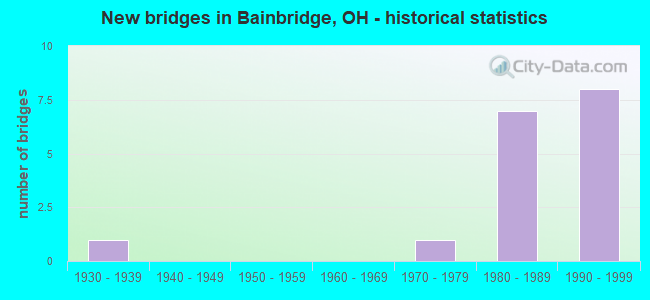
- New bridges - historical statistics
- 11930-1939
- 11970-1979
- 71980-1989
- 81990-1999


- Bridge Condition - Deck
- 11.1%Very good
- 77.8%Good
- 11.1%Satisfactory

- Bridge Condition - Superstructure
- 11.1%Very good
- 77.8%Good
- 11.1%Satisfactory

- Bridge Condition - Substructure
- 11.1%Very good
- 77.8%Good
- 11.1%Satisfactory

- Bridge Condition - Channel
- 28.6%Good
- 28.6%Satisfactory
- 28.6%Fair
- 14.3%Serious

- Bridge Condition - Culverts
- 33.3%Very good
- 33.3%Satisfactory
- 33.3%Fair
Find on map >> Show street view
Structure Number: 2801213, Location: .75 MI N OF US-422 (Lat: 41.398589, Lng: -81.337431), Route carried "on" structure: State highway 306, Year Built: 1997, Status: Open, Structure Length: 0.67m (2.20ft), Average Daily Traffic: 12,740 (year 2018), Truck Traffic: 6%, Average Future Daily Traffic: 17,683 (year 2038), Features Intersected: MC FARLAND CREEK
Minimum Vertical Clearance: 30+ m (98+ ft), Kilometerpoint: 5.729, Lanes on structure: 2, Base Highway Network: Yes, Owner: State Highway Agency, Approaching Roadway Width: 14.6m (47.9ft), Skew: 20 degrees, Material/Design: Concrete, Design/Construction: Culvert, Number Of Spans In Main Unit: 1, Length of Maximum Span: 6.1m (20.0ft)
Condition: Channel: Good, Culverts: Satisfactory, Operating Rating: 42.1 metric tons, Method Used To Determine Operating Rating: Load Factor (LF) rating reported by rating factor (RF) method using MS18 loading, Inventory Rating: 32.4 metric tons, Method Used To Determine Inventory Rating: Load Factor (LF) rating reported by rating factor (RF) method using MS18 loading, Structural Evaluation: Equal to present minimum criteria, Waterway Adequacy: Superior to present desirable criteria, Approach Roadway Alignment: Equal to present desirable criteria, Designated Inspection Frequency: Every 12 months, Inspection Date: May 2021
Find on map >> Show street view
Structure Number: 2801612, Location: APPROX 4000FT W HASKINS (Lat: 41.387789, Lng: -81.339350), Route carried "on" structure: US 422, Year Built: 1989, Status: Open, Structure Length: 2.90m (9.51ft), Average Daily Traffic: 12,253 (year 2015), Truck Traffic: 10%, Average Future Daily Traffic: 17,007 (year 2035), Design Load: HS 20+Mod, Features Intersected: SR 306 (CHILLICOTHE ROAD
Minimum Vertical Clearance: 30+ m (98+ ft), Kilometerpoint: 4.426, Lanes on structure: 2, Lanes under structure: 4, Base Highway Network: Yes, Owner: State Highway Agency, Approaching Roadway Width: 12.2m (40.0ft), Material/Design: Steel, Design/Construction: Stringer/Multi-beam, Number Of Spans In Main Unit: 1, Length of Maximum Span: 27.4m (89.9ft), Curb-To-Curb Width: 12.0m (39.4ft), Out-to-Out Width: 12.9m (42.3ft)
Condition: Deck: Good, Superstructure: Good, Substructure: Good, Operating Rating: 42.1 metric tons, Method Used To Determine Operating Rating: Load Factor (LF) rating reported by rating factor (RF) method using MS18 loading, Inventory Rating: 32.4 metric tons, Method Used To Determine Inventory Rating: Load Factor (LF) rating reported by rating factor (RF) method using MS18 loading, Structural Evaluation: Better than present minimum criteria, Deck Geometry: Equal to present minimum criteria, Underclear: Equal to present minimum criteria, Approach Roadway Alignment: Equal to present desirable criteria, Designated Inspection Frequency: Every 24 months, Inspection Date: April 2021, Deck Structure Type: Concrete Cast-file-Place, Wearing Surface/Protective System: Wearing Surface: Monolithic Concrete, Deck Protection: Epoxy Coated Reinforcing
Find on map >> Show street view
Structure Number: 2801639, Location: APPROX 4000FT W HASKINS (Lat: 41.387539, Lng: -81.339361), Route carried "on" structure: US 422, Year Built: 1989, Status: Open, Structure Length: 2.90m (9.51ft), Average Daily Traffic: 12,253 (year 2015), Truck Traffic: 10%, Average Future Daily Traffic: 17,007 (year 2035), Design Load: HS 20+Mod, Features Intersected: SR 306 (CHILLICOTHE ROAD
Minimum Vertical Clearance: 30+ m (98+ ft), Kilometerpoint: 4.426, Lanes on structure: 2, Lanes under structure: 4, Base Highway Network: Yes, Owner: State Highway Agency, Approaching Roadway Width: 12.2m (40.0ft), Material/Design: Steel, Design/Construction: Stringer/Multi-beam, Number Of Spans In Main Unit: 1, Length of Maximum Span: 27.4m (89.9ft), Curb-To-Curb Width: 12.0m (39.4ft), Out-to-Out Width: 12.9m (42.3ft)
Condition: Deck: Good, Superstructure: Good, Substructure: Good, Operating Rating: 42.1 metric tons, Method Used To Determine Operating Rating: Load Factor (LF) rating reported by rating factor (RF) method using MS18 loading, Inventory Rating: 32.4 metric tons, Method Used To Determine Inventory Rating: Load Factor (LF) rating reported by rating factor (RF) method using MS18 loading, Structural Evaluation: Better than present minimum criteria, Deck Geometry: Equal to present minimum criteria, Underclear: Equal to present minimum criteria, Approach Roadway Alignment: Equal to present desirable criteria, Designated Inspection Frequency: Every 24 months, Inspection Date: April 2021, Deck Structure Type: Concrete Cast-file-Place, Wearing Surface/Protective System: Wearing Surface: Monolithic Concrete, Deck Protection: Epoxy Coated Reinforcing
Find on map >> Show street view
Structure Number: 2803364, Location: 5.56 MI W OF SR 44 (Lat: 41.385700, Lng: -81.323039), Route carried "on" structure: County highway C0191, Year Built: 1990, Status: Open, Structure Length: 7.04m (23.10ft), Average Daily Traffic: 20,040 (year 2001), Truck Traffic: 15%, Average Future Daily Traffic: 24,572 (year 2021), Design Load: HS 20+Mod, Features Intersected: USR 422 ALT (0361), Facility Carried by Structure: HASKINS ROAD
Minimum Vertical Clearance: 30+ m (98+ ft), Kilometerpoint: 4.265, Lanes on structure: 2, Lanes under structure: 4, Owner: State Highway Agency, Approaching Roadway Width: 10.4m (34.1ft), Material/Design: Steel continuous, Design/Construction: Stringer/Multi-beam, Number Of Spans In Main Unit: 2, Length of Maximum Span: 36.3m (119.1ft), Curb-To-Curb Width: 9.1m (29.9ft), Out-to-Out Width: 10.2m (33.5ft)
Condition: Deck: Good, Superstructure: Good, Substructure: Good, Operating Rating: 42.1 metric tons, Method Used To Determine Operating Rating: Load Factor (LF) rating reported by rating factor (RF) method using MS18 loading, Inventory Rating: 32.4 metric tons, Method Used To Determine Inventory Rating: Load Factor (LF) rating reported by rating factor (RF) method using MS18 loading, Structural Evaluation: Better than present minimum criteria, Deck Geometry: Meets minimum limits, Underclear: Better than present minimum criteria, Approach Roadway Alignment: Equal to present desirable criteria, Designated Inspection Frequency: Every 24 months, Inspection Date: April 2021, Deck Structure Type: Concrete Cast-file-Place, Wearing Surface/Protective System: Wearing Surface: Latex Concrete, Deck Protection: Epoxy Coated Reinforcing
Find on map >> Show street view
Structure Number: 280338, Location: 4.79 MI W OF SR 44 (Lat: 41.383950, Lng: -81.308419), Route carried "on" structure: US 422, Year Built: 1990, Status: Open, Structure Length: 3.66m (12.01ft), Average Daily Traffic: 8,852 (year 2015), Truck Traffic: 10%, Average Future Daily Traffic: 12,287 (year 2035), Design Load: HS 20+Mod, Features Intersected: SNYDER ROAD
Minimum Vertical Clearance: 30+ m (98+ ft), Kilometerpoint: 7.033, Lanes on structure: 2, Lanes under structure: 2, Base Highway Network: Yes, Owner: State Highway Agency, Approaching Roadway Width: 12.2m (40.0ft), Material/Design: Prestressed concrete, Design/Construction: Stringer/Multi-beam, Number Of Spans In Main Unit: 3, Length of Maximum Span: 11.9m (39.0ft), Curb-To-Curb Width: 12.2m (40.0ft), Out-to-Out Width: 13.3m (43.6ft)
Condition: Deck: Good, Superstructure: Good, Substructure: Good, Operating Rating: 42.1 metric tons, Method Used To Determine Operating Rating: Load Factor (LF) rating reported by rating factor (RF) method using MS18 loading, Inventory Rating: 32.4 metric tons, Method Used To Determine Inventory Rating: Load Factor (LF) rating reported by rating factor (RF) method using MS18 loading, Structural Evaluation: Better than present minimum criteria, Deck Geometry: Better than present minimum criteria, Underclear: Meets minimum limits, Approach Roadway Alignment: Equal to present desirable criteria, Designated Inspection Frequency: Every 24 months, Inspection Date: April 2021, Deck Structure Type: Concrete Cast-file-Place, Wearing Surface/Protective System: Wearing Surface: Latex Concrete
Find on map >> Show street view
Structure Number: 2803399, Location: 4.79 MI W OF SR 44 (Lat: 41.383719, Lng: -81.308450), Route carried "on" structure: US 422, Year Built: 1990, Status: Open, Structure Length: 3.66m (12.01ft), Average Daily Traffic: 8,852 (year 2015), Truck Traffic: 10%, Average Future Daily Traffic: 12,287 (year 2035), Design Load: HS 20+Mod, Features Intersected: SNYDER ROAD
Minimum Vertical Clearance: 30+ m (98+ ft), Kilometerpoint: 7.033, Lanes on structure: 2, Lanes under structure: 2, Base Highway Network: Yes, Owner: State Highway Agency, Approaching Roadway Width: 12.2m (40.0ft), Material/Design: Prestressed concrete, Design/Construction: Stringer/Multi-beam, Number Of Spans In Main Unit: 3, Length of Maximum Span: 11.9m (39.0ft), Curb-To-Curb Width: 12.2m (40.0ft), Out-to-Out Width: 13.3m (43.6ft)
Condition: Deck: Good, Superstructure: Good, Substructure: Good, Operating Rating: 42.1 metric tons, Method Used To Determine Operating Rating: Load Factor (LF) rating reported by rating factor (RF) method using MS18 loading, Inventory Rating: 32.4 metric tons, Method Used To Determine Inventory Rating: Load Factor (LF) rating reported by rating factor (RF) method using MS18 loading, Structural Evaluation: Better than present minimum criteria, Deck Geometry: Better than present minimum criteria, Underclear: Meets minimum limits, Approach Roadway Alignment: Equal to present desirable criteria, Designated Inspection Frequency: Every 24 months, Inspection Date: April 2021, Deck Structure Type: Concrete Cast-file-Place, Wearing Surface/Protective System: Wearing Surface: Latex Concrete
Find on map >> Show street view
Structure Number: 2830035, Location: 853 FT FROM CHAGRIN ROAD (Lat: 41.402300, Lng: -81.353911), Route carried "on" structure: County highway T0812, Year Built: 1990, Status: Open, Structure Length: 1.73m (5.68ft), Average Daily Traffic: 200 (year 2017), Truck Traffic: 2%, Average Future Daily Traffic: 278 (year 2037), Design Load: HS 20, Features Intersected: MCFARLAND CREEK, Facility Carried by Structure: BRIDGEWAY DR
Minimum Vertical Clearance: 30+ m (98+ ft), Kilometerpoint: 0.257, Lanes on structure: 2, Owner: County Highway Agency, Approaching Roadway Width: 8.5m (27.9ft), Skew: 3 degrees, Material/Design: Prestressed concrete, Design/Construction: Box Beam or Girders - Multiple, Number Of Spans In Main Unit: 1, Length of Maximum Span: 16.8m (55.1ft), Curb-To-Curb Width: 9.1m (29.9ft), Out-to-Out Width: 9.3m (30.5ft)
Condition: Deck: Very good, Superstructure: Good, Substructure: Very good, Channel: Fair, Operating Rating: 55.1 metric tons, Method Used To Determine Operating Rating: Load Factor (LF) rating reported by rating factor (RF) method using MS18 loading, Inventory Rating: 32.4 metric tons, Method Used To Determine Inventory Rating: Load Factor (LF) rating reported by rating factor (RF) method using MS18 loading, Structural Evaluation: Better than present minimum criteria, Deck Geometry: Equal to present minimum criteria, Waterway Adequacy: Superior to present desirable criteria, Approach Roadway Alignment: Equal to present desirable criteria, Designated Inspection Frequency: Every 24 months, Inspection Date: December 2021, Deck Structure Type: Concrete Cast-file-Place, Wearing Surface/Protective System: Wearing Surface: Bituminous, Deck Protection: Epoxy Coated Reinforcing
Find on map >> Show street view
Structure Number: 2832356, Location: 420 FT E OF WESTHILL DR (Lat: 41.398381, Lng: -81.352111), Route carried "on" structure: County highway C0009, Year Built: 1980, Status: Open, Structure Length: 0.86m (2.82ft), Average Daily Traffic: 7,118 (year 2017), Truck Traffic: 2%, Average Future Daily Traffic: 9,880 (year 2037), Design Load: HS 20+Mod, Features Intersected: MCFARLAND CREEK, Facility Carried by Structure: CHAGRIN RD
Minimum Vertical Clearance: 30+ m (98+ ft), Kilometerpoint: 4.152, Lanes on structure: 2, Owner: County Highway Agency, Approaching Roadway Width: 9.8m (32.2ft), Skew: 1 degrees, Material/Design: Concrete, Design/Construction: Culvert, Number Of Spans In Main Unit: 2, Length of Maximum Span: 3.8m (12.5ft)
Condition: Channel: Satisfactory, Culverts: Very good, Operating Rating: 71.3 metric tons, Method Used To Determine Operating Rating: Load Factor (LF) rating reported by rating factor (RF) method using MS18 loading, Inventory Rating: 42.1 metric tons, Method Used To Determine Inventory Rating: Load Factor (LF) rating reported by rating factor (RF) method using MS18 loading, Structural Evaluation: Equal to present desirable criteria, Waterway Adequacy: Superior to present desirable criteria, Approach Roadway Alignment: Equal to present desirable criteria, Designated Inspection Frequency: Every 24 months, Inspection Date: December 2021
Find on map >> Show street view
Structure Number: 2832364, Location: 475' W OF WEST HILL DRIVE (Lat: 41.399819, Lng: -81.354539), Route carried "on" structure: County highway C0009, Year Built: 1980, Status: Open, Structure Length: 1.07m (3.51ft), Average Daily Traffic: 7,118 (year 2017), Truck Traffic: 5%, Average Future Daily Traffic: 9,880 (year 2037), Design Load: HS 20+Mod, Features Intersected: SILSBY CREEK, Facility Carried by Structure: CHAGRIN RD
Minimum Vertical Clearance: 30+ m (98+ ft), Kilometerpoint: 3.879, Lanes on structure: 2, Owner: County Highway Agency, Approaching Roadway Width: 9.8m (32.2ft), Skew: 1 degrees, Material/Design: Concrete, Design/Construction: Slab, Number Of Spans In Main Unit: 1, Length of Maximum Span: 9.9m (32.5ft), Curb-To-Curb Width: 11.8m (38.7ft), Out-to-Out Width: 12.2m (40.0ft)
Condition: Deck: Satisfactory, Superstructure: Satisfactory, Substructure: Satisfactory, Channel: Good, Operating Rating: 71.3 metric tons, Method Used To Determine Operating Rating: Load Factor (LF) rating reported by rating factor (RF) method using MS18 loading, Inventory Rating: 42.1 metric tons, Method Used To Determine Inventory Rating: Load Factor (LF) rating reported by rating factor (RF) method using MS18 loading, Structural Evaluation: Equal to present minimum criteria, Deck Geometry: Somewhat better than minimum adequacy, Waterway Adequacy: Superior to present desirable criteria, Approach Roadway Alignment: Equal to present desirable criteria, Designated Inspection Frequency: Every 12 months, Inspection Date: December 2021, Deck Structure Type: Concrete Cast-file-Place, Wearing Surface/Protective System: Wearing Surface: Bituminous
Find on map >> Show street view
Structure Number: 2832372, Location: 140' N OF BAINBROOK DRIVE (Lat: 41.372469, Lng: -81.345389), Route carried "on" structure: County highway T0578, Year Built: 1979, Status: Open, Structure Length: 0.66m (2.17ft), Average Daily Traffic: 213 (year 2017), Truck Traffic: 2%, Average Future Daily Traffic: 296 (year 2037), Features Intersected: PETTIBONE CREEK, Facility Carried by Structure: ROLLING BROOK DR
Minimum Vertical Clearance: 30+ m (98+ ft), Kilometerpoint: 0.048, Lanes on structure: 2, Owner: County Highway Agency, Approaching Roadway Width: 9.8m (32.2ft), Skew: 2 degrees, Material/Design: Steel, Design/Construction: Culvert, Number Of Spans In Main Unit: 3, Length of Maximum Span: 1.6m (5.2ft)
Condition: Channel: Fair, Culverts: Fair, Operating Rating: 48.6 metric tons, Method Used To Determine Operating Rating: Load and Resistance Factor Rating (LRFR) rating reported by rating factor(RF) method using HL-93 loadings, Inventory Rating: 35.6 metric tons, Method Used To Determine Inventory Rating: Load and Resistance Factor Rating (LRFR) rating reported by rating factor(RF) method using HL-93 loadings, Structural Evaluation: Somewhat better than minimum adequacy, Waterway Adequacy: Equal to present minimum criteria, Approach Roadway Alignment: Equal to present desirable criteria, Designated Inspection Frequency: Every 12 months, Inspection Date: November 2021
Find on map >> Show street view
Structure Number: 2832488, Location: APPROX 1 MI WEST OF SR306 (Lat: 41.418639, Lng: -81.354419), Route carried "on" structure: County highway C0606, Year Built: 1932, Year Reconstructed: 1991, Status: Open, Structure Length: 0.75m (2.46ft), Average Daily Traffic: 9,626 (year 2017), Truck Traffic: 5%, Average Future Daily Traffic: 13,361 (year 2037), Design Load: HS 20+Mod, Features Intersected: MCFARLAND CREEK, Facility Carried by Structure: WASHINGTON ST
Minimum Vertical Clearance: 30+ m (98+ ft), Kilometerpoint: 1.336, Lanes on structure: 2, Owner: County Highway Agency, Approaching Roadway Width: 12.2m (40.0ft), Material/Design: Prestressed concrete, Design/Construction: Box Beam or Girders - Multiple, Number Of Spans In Main Unit: 1, Length of Maximum Span: 7.2m (23.6ft), Curb or Sidewalk Widths: Left: 0.0m, Right: 0.2m (0.7ft), Curb-To-Curb Width: 13.2m (43.3ft), Out-to-Out Width: 13.4m (44.0ft)
Condition: Deck: Good, Superstructure: Very good, Substructure: Good, Channel: Satisfactory, Operating Rating: 87.5 metric tons, Method Used To Determine Operating Rating: Load Factor (LF) rating reported by rating factor (RF) method using MS18 loading, Inventory Rating: 51.8 metric tons, Method Used To Determine Inventory Rating: Load Factor (LF) rating reported by rating factor (RF) method using MS18 loading, Structural Evaluation: Better than present minimum criteria, Deck Geometry: Somewhat better than minimum adequacy, Waterway Adequacy: Equal to present minimum criteria, Approach Roadway Alignment: Better than present minimum criteria, Designated Inspection Frequency: Every 24 months, Inspection Date: December 2021, Deck Structure Type: Concrete Cast-file-Place, Wearing Surface/Protective System: Wearing Surface: Bituminous, Deck Protection: Epoxy Coated Reinforcing
Find on map >> Show street view
Structure Number: 2832534, Location: 0.3 MI S OF BAINBRIDGE RD (Lat: 41.384189, Lng: -81.308419), Route carried "on" structure: County highway T0192, Year Built: 1989, Status: Open, Structure Length: 0.73m (2.40ft), Average Daily Traffic: 1,889 (year 2017), Truck Traffic: 2%, Average Future Daily Traffic: 2,622 (year 2037), Design Load: HS 20+Mod, Features Intersected: BR OF MCFARLAND CREEK, Facility Carried by Structure: SNYDER RD
Minimum Vertical Clearance: 30+ m (98+ ft), Kilometerpoint: 4.088, Lanes on structure: 2, Owner: State Highway Agency, Approaching Roadway Width: 10.4m (34.1ft), Material/Design: Concrete, Design/Construction: Frame, Number Of Spans In Main Unit: 2, Length of Maximum Span: 3.0m (9.8ft), Curb-To-Curb Width: 10.4m (34.1ft), Out-to-Out Width: 12.0m (39.4ft)
Condition: Deck: Good, Superstructure: Good, Substructure: Good, Channel: Serious, Operating Rating: 58.3 metric tons, Method Used To Determine Operating Rating: Load Factor (LF) rating reported by rating factor (RF) method using MS18 loading, Inventory Rating: 35.6 metric tons, Method Used To Determine Inventory Rating: Load Factor (LF) rating reported by rating factor (RF) method using MS18 loading, Structural Evaluation: Better than present minimum criteria, Deck Geometry: Equal to present minimum criteria, Waterway Adequacy: Better than present minimum criteria, Approach Roadway Alignment: Equal to present desirable criteria, Designated Inspection Frequency: Every 24 months, Inspection Date: December 2021, Deck Structure Type: Concrete Cast-file-Place, Wearing Surface/Protective System: Wearing Surface: Bituminous, Membrane: Preformed Fabric
Find on map >> Show street view
Structure Number: 2801612, Location: APPROX 4000FT W HASKINS (Lat: 41.387789, Lng: -81.339350), Route carried "under" structure: State highway 306, Year Built: 1989, Structure Length: 0. m, Average Daily Traffic: 19,128 (year 2011), Truck Traffic: 4%, Features Intersected: USR 422 (GEA-422-0275L), Facility Carried by Structure: USR 422
Minimum Vertical Clearance: 4.83m (15.85ft), Kilometerpoint: 4.538, Lanes on structure: 2, Lanes under structure: 4, Material/Design: Steel, Design/Construction: Stringer/Multi-beam, Length of Maximum Span: 27.4m (89.9ft)
Find on map >> Show street view
Structure Number: 2801639, Location: APPROX 4000FT W HASKINS (Lat: 41.387539, Lng: -81.339361), Route carried "under" structure: State highway 306, Year Built: 1989, Structure Length: 0. m, Average Daily Traffic: 19,128 (year 2011), Truck Traffic: 4%, Features Intersected: USR 422 (GEA-422-0275R), Facility Carried by Structure: USR 422
Minimum Vertical Clearance: 4.89m (16.04ft), Kilometerpoint: 4.522, Lanes on structure: 2, Lanes under structure: 4, Material/Design: Steel, Design/Construction: Stringer/Multi-beam, Length of Maximum Span: 27.4m (89.9ft)
Find on map >> Show street view
Structure Number: 2803364, Location: 5.56 MI W OF SR 44 (Lat: 41.385700, Lng: -81.323039), Route carried "under" structure: US 422, Year Built: 1990, Structure Length: 0. m, Average Daily Traffic: 17,703 (year 2015), Truck Traffic: 10%, Features Intersected: HASKINS ROAD, Facility Carried by Structure: HASKINS ROAD
Minimum Vertical Clearance: 5.72m (18.77ft), Kilometerpoint: 5.810, Lanes on structure: 2, Lanes under structure: 4, Material/Design: Steel continuous, Design/Construction: Stringer/Multi-beam, Length of Maximum Span: 36.3m (119.1ft)
Find on map >> Show street view
Structure Number: 280338, Location: 4.79 MI W OF SR 44 (Lat: 41.383950, Lng: -81.308419), Route carried "under" structure: County highway 192, Year Built: 1990, Structure Length: 0. m, Average Daily Traffic: 100 (year 1993), Truck Traffic: 10%, Features Intersected: USR 422 ALT WB (0438 L), Facility Carried by Structure: USR 422
Minimum Vertical Clearance: 4.62m (15.16ft), Kilometerpoint: 3.750, Lanes on structure: 2, Lanes under structure: 2, Material/Design: Prestressed concrete, Design/Construction: Stringer/Multi-beam, Length of Maximum Span: 11.9m (39.0ft)
Find on map >> Show street view
Structure Number: 2803399, Location: 4.79 MI W OF SR 44 (Lat: 41.383719, Lng: -81.308450), Route carried "under" structure: County highway 192, Year Built: 1990, Structure Length: 0. m, Average Daily Traffic: 100 (year 1992), Truck Traffic: 10%, Features Intersected: USR 422 ALT EB (0438 R), Facility Carried by Structure: USR 422
Minimum Vertical Clearance: 4.40m (14.44ft), Kilometerpoint: 3.718, Lanes on structure: 2, Lanes under structure: 2, Material/Design: Prestressed concrete, Design/Construction: Stringer/Multi-beam, Length of Maximum Span: 11.9m (39.0ft)