Bridge Statistics for Bakersfield, Missouri (MO)
Condition, Traffic, Stress, Structural Evaluation, Project Costs
- National Bridge Inventory (NBI) Statistics
- 10Number of bridges
- 82ft / 25.4mTotal length
- $2,250,000Total costs
- 9,353Total average daily traffic
- 835Total average daily truck traffic
- 15,743Total future (year 2041) average daily traffic
- National Bridge Inventory (NBI) Registered Bridges for Bakersfield
- No street view available for this location
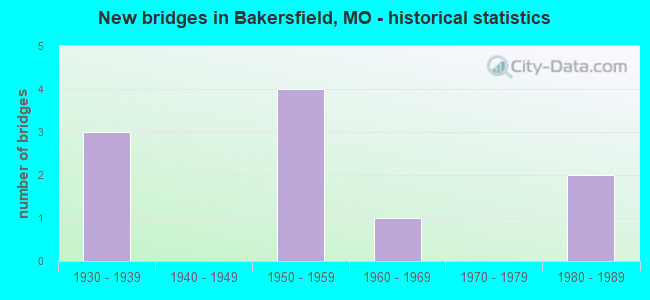
- New bridges - historical statistics
- 31930-1939
- 41950-1959
- 11960-1969
- 21980-1989

- Reconstructed bridges - Historical Statistics
- 11970-1979
- 11980-1989

- Bridge Condition - Deck
- 40.0%Good
- 40.0%Satisfactory
- 20.0%Fair

- Bridge Condition - Superstructure
- 20.0%Good
- 40.0%Satisfactory
- 20.0%Fair
- 20.0%Poor

- Bridge Condition - Substructure
- 40.0%Good
- 40.0%Fair
- 20.0%Poor

- Bridge Condition - Channel
- 30.0%Good
- 10.0%Satisfactory
- 60.0%Fair
Find on map >> Show street view
Structure Number: 3766, Location: S 25 T 30 N R 21 W (Lat: 37.294236, Lng: -93.192458), Route carried "on" structure: State highway AA, Year Built: 1989, Status: Posted for load, Structure Length: 3.63m (11.91ft), Average Daily Traffic: 2,241 (year 2021), Truck Traffic: 4%, Average Future Daily Traffic: 3,586 (year 2041), Design Load: H 20, Features Intersected: POTTER BR
Minimum Vertical Clearance: 30+ m (98+ ft), Kilometerpoint: 6.462, Lanes on structure: 2, Owner: State Highway Agency, Approaching Roadway Width: 12.2m (40.0ft), Skew: 4 degrees, Material/Design: Prestressed concrete continuous, Design/Construction: Tee Beam, Number Of Spans In Main Unit: 3, Length of Maximum Span: 12.2m (40.0ft), Curb or Sidewalk Widths: Left: 0.2m (0.7ft), Right: 0.2m (0.7ft), Curb-To-Curb Width: 11.8m (38.7ft), Out-to-Out Width: 12.6m (41.3ft)
Condition: Deck: Good, Superstructure: Satisfactory, Substructure: Good, Channel: Good, Operating Rating: 55.8 metric tons, Method Used To Determine Operating Rating: Load Factor (LF), Inventory Rating: 33.3 metric tons, Method Used To Determine Inventory Rating: Load Factor (LF), Structural Evaluation: Equal to present minimum criteria, Deck Geometry: Somewhat better than minimum adequacy, Waterway Adequacy: Equal to present desirable criteria, Approach Roadway Alignment: Equal to present desirable criteria, Designated Inspection Frequency: Every 24 months, Inspection Date: July 2020, Deck Structure Type: Concrete Cast-file-Place, Wearing Surface/Protective System: Wearing Surface: Monolithic Concrete, Deck Protection: Epoxy Coated Reinforcing
Find on map >> Show street view
Structure Number: 4359, Location: S 14 T 21 N R 11 W (Lat: 36.500000, Lng: -92.139206), Route carried "on" structure: State highway AR, Year Built: 1988, Status: Open, Structure Length: 4.72m (15.49ft), Average Daily Traffic: 167 (year 2021), Truck Traffic: 8%, Average Future Daily Traffic: 267 (year 2041), Design Load: H 10, Features Intersected: BENNETT BYU
Minimum Vertical Clearance: 30+ m (98+ ft), Kilometerpoint: 2.610, Lanes on structure: 2, Owner: State Highway Agency, Approaching Roadway Width: 7.3m (24.0ft), Skew: 2 degrees, Material/Design: Prestressed concrete continuous, Design/Construction: Tee Beam, Number Of Spans In Main Unit: 4, Length of Maximum Span: 13.4m (44.0ft), Curb-To-Curb Width: 7.3m (24.0ft), Out-to-Out Width: 8.1m (26.6ft)
Condition: Deck: Good, Superstructure: Good, Substructure: Good, Channel: Fair, Operating Rating: 59.4 metric tons, Method Used To Determine Operating Rating: Load Factor (LF), Inventory Rating: 32.4 metric tons, Method Used To Determine Inventory Rating: Load Factor (LF), Structural Evaluation: Better than present minimum criteria, Deck Geometry: Somewhat better than minimum adequacy, Waterway Adequacy: Equal to present desirable criteria, Approach Roadway Alignment: Equal to present minimum criteria, Designated Inspection Frequency: Every 24 months, Inspection Date: January 2022, Deck Structure Type: Concrete Cast-file-Place, Wearing Surface/Protective System: Wearing Surface: Monolithic Concrete, Deck Protection: Internally Sealed
Find on map >> Show street view
Structure Number: 5616, Location: S 33 T 47 N R 2 E (Lat: 38.786889, Lng: -90.803608), Route carried "on" structure: ServiceState highway 64, Year Built: 1935, Year Reconstructed: 1977, Status: Posted for load, Structure Length: 7.02m (23.03ft), Average Daily Traffic: 2,288 (year 2021), Truck Traffic: 4%, Average Future Daily Traffic: 4,462 (year 2041), Design Load: H 20, Features Intersected: PERUQUE CR
Minimum Vertical Clearance: 30+ m (98+ ft), Kilometerpoint: 1.445, Lanes on structure: 2, Owner: State Highway Agency, Approaching Roadway Width: 11.6m (38.1ft), Material/Design: Steel, Design/Construction: Truss - Thru, Number Of Spans In Main Unit: 1, Number Of Approach Spans: 3, Length of Maximum Span: 31.1m (102.0ft), Curb-To-Curb Width: 9.2m (30.2ft), Out-to-Out Width: 10.1m (33.1ft)
Condition: Deck: Satisfactory, Superstructure: Poor, Substructure: Poor, Channel: Good, Operating Rating: 45.9 metric tons, Method Used To Determine Operating Rating: Load Factor (LF), Inventory Rating: 27.9 metric tons, Method Used To Determine Inventory Rating: Load Factor (LF), Structural Evaluation: Meets minimum limits, Deck Geometry: Meets minimum limits, Waterway Adequacy: Equal to present desirable criteria, Approach Roadway Alignment: Equal to present desirable criteria, Length Of Structure Improvement: 0.80m (2.62ft), Designated Inspection Frequency: Every 24 months, Critical Feature Inspection Frequency: Every 24 months, Underwater Inspection Frequency: Every 60 months, Inspection Date: May 2020, Critical Feature Inspection Date: May 2020, Underwater Inspection Date: October 2021, Bridge Improvement Cost: $684,000, Roadway Improvement Cost: $68,000, Total Project Cost: $1,026,000 ( Estimate for 2022), Deck Structure Type: Concrete Cast-file-Place, Wearing Surface/Protective System: Wearing Surface: Latex Concrete
Find on map >> Show street view
Structure Number: 7634, Location: S 2 T 21 N R 11 W (Lat: 36.522389, Lng: -92.140661), Route carried "on" structure: State highway 142, Year Built: 1953, Status: Open, Structure Length: 3.93m (12.89ft), Average Daily Traffic: 584 (year 2021), Truck Traffic: 18%, Average Future Daily Traffic: 934 (year 2041), Design Load: H 10, Features Intersected: BENNETT BAY
Minimum Vertical Clearance: 30+ m (98+ ft), Kilometerpoint: 0.183, Lanes on structure: 2, Owner: State Highway Agency, Approaching Roadway Width: 6.7m (22.0ft), Material/Design: Concrete, Design/Construction: Slab, Number Of Spans In Main Unit: 6, Length of Maximum Span: 6.8m (22.3ft), Curb-To-Curb Width: 6.1m (20.0ft), Out-to-Out Width: 6.4m (21.0ft)
Condition: Deck: Satisfactory, Superstructure: Satisfactory, Substructure: Fair, Channel: Fair, Operating Rating: 26.1 metric tons, Method Used To Determine Operating Rating: Allowable Stress (AS), Inventory Rating: 12.6 metric tons, Method Used To Determine Inventory Rating: Allowable Stress (AS), Structural Evaluation: Meets minimum limits, Deck Geometry: High priority of corrective action, Waterway Adequacy: High priority of corrective action, Approach Roadway Alignment: Meets minimum limits, Length Of Structure Improvement: 0.49m (1.61ft), Designated Inspection Frequency: Every 24 months, Inspection Date: January 2022, Bridge Improvement Cost: $560,000, Roadway Improvement Cost: $56,000, Total Project Cost: $840,000 ( Estimate for 2022), Deck Structure Type: Concrete Cast-file-Place, Wearing Surface/Protective System: Wearing Surface: Bituminous
Find on map >> Show street view
Structure Number: 7667, Location: S 16 T 22 N R 11 W (Lat: 36.578000, Lng: -92.173628), Route carried "on" structure: State highway V, Year Built: 1954, Status: Open, Structure Length: 1.10m (3.61ft), Average Daily Traffic: 273 (year 2021), Truck Traffic: 10%, Average Future Daily Traffic: 437 (year 2041), Design Load: H 10, Features Intersected: SCOFIELD HOLLOW
Minimum Vertical Clearance: 30+ m (98+ ft), Kilometerpoint: 6.943, Lanes on structure: 2, Owner: State Highway Agency, Approaching Roadway Width: 7.3m (24.0ft), Skew: 3 degrees, Material/Design: Concrete continuous, Design/Construction: Culvert, Number Of Spans In Main Unit: 3, Length of Maximum Span: 3.0m (9.8ft), Curb-To-Curb Width: 7.3m (24.0ft), Out-to-Out Width: 7.9m (25.9ft)
Condition: Channel: Good, Culverts: Satisfactory, Operating Rating: 50.4 metric tons, Method Used To Determine Operating Rating: Load Factor (LF), Inventory Rating: 29.7 metric tons, Method Used To Determine Inventory Rating: Load Factor (LF), Structural Evaluation: Equal to present minimum criteria, Deck Geometry: Somewhat better than minimum adequacy, Waterway Adequacy: Equal to present desirable criteria, Approach Roadway Alignment: Equal to present minimum criteria, Designated Inspection Frequency: Every 24 months, Inspection Date: January 2022
Find on map >> Show street view
Structure Number: 7668, Location: S 15 T 22 N R 11 W (Lat: 36.574528, Lng: -92.170686), Route carried "on" structure: State highway V, Year Built: 1954, Status: Open, Structure Length: 0.67m (2.20ft), Average Daily Traffic: 273 (year 2021), Truck Traffic: 10%, Average Future Daily Traffic: 437 (year 2041), Design Load: H 10, Features Intersected: S BRIDGES CR
Minimum Vertical Clearance: 30+ m (98+ ft), Kilometerpoint: 7.440, Lanes on structure: 2, Owner: State Highway Agency, Approaching Roadway Width: 7.3m (24.0ft), Skew: 2 degrees, Material/Design: Concrete continuous, Design/Construction: Culvert, Number Of Spans In Main Unit: 2, Length of Maximum Span: 3.0m (9.8ft), Curb-To-Curb Width: 7.3m (24.0ft), Out-to-Out Width: 7.9m (25.9ft)
Condition: Channel: Fair, Culverts: Satisfactory, Operating Rating: 40.5 metric tons, Method Used To Determine Operating Rating: Load Factor (LF), Inventory Rating: 24.3 metric tons, Method Used To Determine Inventory Rating: Load Factor (LF), Structural Evaluation: Equal to present minimum criteria, Deck Geometry: Somewhat better than minimum adequacy, Waterway Adequacy: Equal to present desirable criteria, Approach Roadway Alignment: Equal to present minimum criteria, Designated Inspection Frequency: Every 24 months, Inspection Date: January 2022
Find on map >> Show street view
Structure Number: 7863, Location: S 32 T 22 N R 11 W (Lat: 36.539142, Lng: -92.192561), Route carried "on" structure: State highway O, Year Built: 1954, Status: Open, Structure Length: 0.66m (2.17ft), Average Daily Traffic: 588 (year 2021), Truck Traffic: 12%, Average Future Daily Traffic: 941 (year 2041), Design Load: H 10, Features Intersected: BARREN CR
Minimum Vertical Clearance: 30+ m (98+ ft), Kilometerpoint: 9.001, Lanes on structure: 2, Owner: State Highway Agency, Approaching Roadway Width: 7.3m (24.0ft), Material/Design: Concrete continuous, Design/Construction: Culvert, Number Of Spans In Main Unit: 2, Length of Maximum Span: 3.0m (9.8ft), Curb-To-Curb Width: 8.1m (26.6ft), Out-to-Out Width: 8.7m (28.5ft)
Condition: Channel: Satisfactory, Culverts: Satisfactory, Operating Rating: 42.3 metric tons, Method Used To Determine Operating Rating: Load Factor (LF), Inventory Rating: 25.2 metric tons, Method Used To Determine Inventory Rating: Load Factor (LF), Structural Evaluation: Equal to present minimum criteria, Deck Geometry: Somewhat better than minimum adequacy, Waterway Adequacy: Equal to present desirable criteria, Approach Roadway Alignment: Equal to present minimum criteria, Designated Inspection Frequency: Every 24 months, Inspection Date: January 2022
Find on map >> Show street view
Structure Number: 816, Location: S 30 T 22 N R 10 W (Lat: 36.549789, Lng: -92.100233), Route carried "on" structure: State highway YY, Year Built: 1962, Status: Open, Structure Length: 0.75m (2.46ft), Average Daily Traffic: 121 (year 2021), Truck Traffic: 15%, Average Future Daily Traffic: 182 (year 2041), Design Load: H 15, Features Intersected: HALSEY BR
Minimum Vertical Clearance: 30+ m (98+ ft), Kilometerpoint: 4.027, Lanes on structure: 2, Owner: State Highway Agency, Approaching Roadway Width: 7.3m (24.0ft), Material/Design: Concrete continuous, Design/Construction: Culvert, Number Of Spans In Main Unit: 2, Length of Maximum Span: 3.7m (12.1ft), Curb-To-Curb Width: 7.9m (25.9ft), Out-to-Out Width: 8.5m (27.9ft)
Condition: Channel: Fair, Culverts: Satisfactory, Operating Rating: 54.0 metric tons, Method Used To Determine Operating Rating: Load Factor (LF), Inventory Rating: 32.4 metric tons, Method Used To Determine Inventory Rating: Load Factor (LF), Structural Evaluation: Equal to present minimum criteria, Deck Geometry: Somewhat better than minimum adequacy, Waterway Adequacy: Equal to present minimum criteria, Approach Roadway Alignment: Equal to present minimum criteria, Designated Inspection Frequency: Every 24 months, Inspection Date: October 2020
Find on map >> Show street view
Structure Number: 8579, Location: S 35 T 22 N R 11 W (Lat: 36.540339, Lng: -92.138692), Route carried "on" structure: State highway 101, Year Built: 1930, Year Reconstructed: 1991, Status: Open, Structure Length: 1.08m (3.54ft), Average Daily Traffic: 2,697 (year 2021), Truck Traffic: 14%, Average Future Daily Traffic: 4,315 (year 2041), Design Load: H 10, Features Intersected: DRY RUN
Minimum Vertical Clearance: 30+ m (98+ ft), Kilometerpoint: 9.803, Lanes on structure: 2, Owner: State Highway Agency, Approaching Roadway Width: 7.6m (24.9ft), Skew: 4 degrees, Material/Design: Concrete continuous, Design/Construction: Culvert, Number Of Spans In Main Unit: 2, Length of Maximum Span: 3.7m (12.1ft)
Condition: Channel: Fair, Culverts: Satisfactory, Operating Rating: 83.7 metric tons, Method Used To Determine Operating Rating: Load Factor (LF), Inventory Rating: 50.4 metric tons, Method Used To Determine Inventory Rating: Load Factor (LF), Structural Evaluation: Equal to present minimum criteria, Waterway Adequacy: Equal to present desirable criteria, Approach Roadway Alignment: Equal to present minimum criteria, Designated Inspection Frequency: Every 24 months, Inspection Date: January 2022
Find on map >> Show street view
Structure Number: 9472, Location: S 30 T 22 N R 10 W (Lat: 36.552003, Lng: -92.100256), Route carried "on" structure: State highway YY, Year Built: 1934, Status: Posted for load, Structure Length: 1.83m (6.00ft), Average Daily Traffic: 121 (year 2021), Truck Traffic: 15%, Average Future Daily Traffic: 182 (year 2041), Design Load: H 10, Features Intersected: BENNETT BYU
Minimum Vertical Clearance: 30+ m (98+ ft), Kilometerpoint: 3.776, Lanes on structure: 1, Owner: State Highway Agency, Approaching Roadway Width: 5.5m (18.0ft), Material/Design: Concrete, Design/Construction: Tee Beam, Number Of Spans In Main Unit: 2, Length of Maximum Span: 9.1m (29.9ft), Curb-To-Curb Width: 6.1m (20.0ft), Out-to-Out Width: 7.3m (24.0ft)
Condition: Deck: Fair, Superstructure: Fair, Substructure: Fair, Channel: Fair, Operating Rating: 23.4 metric tons, Method Used To Determine Operating Rating: Allowable Stress (AS), Inventory Rating: 9.9 metric tons, Method Used To Determine Inventory Rating: Allowable Stress (AS), Structural Evaluation: High priority of replacement, Deck Geometry: Meets minimum limits, Waterway Adequacy: Meets minimum limits, Approach Roadway Alignment: Meets minimum limits, Bridge Posting: Required (Relationship of Operating Rating to Maximum Legal Load: 20.0 - 29.9% below), Length Of Structure Improvement: 0.25m (0.82ft), Designated Inspection Frequency: Every 24 months, Inspection Date: December 2020, Bridge Improvement Cost: $256,000, Roadway Improvement Cost: $26,000, Total Project Cost: $384,000 ( Estimate for 2022), Deck Structure Type: Concrete Cast-file-Place, Wearing Surface/Protective System: Wearing Surface: Bituminous, Membrane: Built-up