Bridge Statistics for Bald Knob, Arkansas (AR)
Condition, Traffic, Stress, Structural Evaluation, Project Costs
- National Bridge Inventory (NBI) Statistics
- 46Number of bridges
- 328ft / 99.7mTotal length
- $3,075,000Total costs
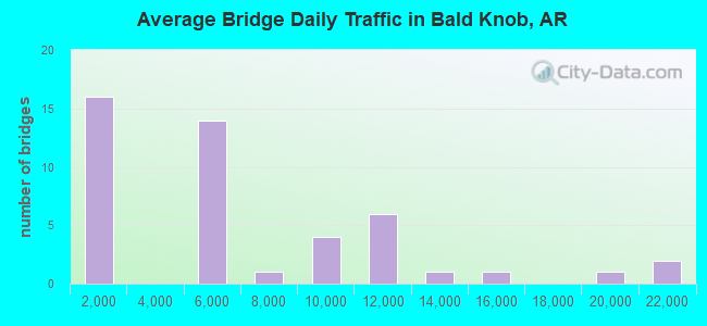
- 270,394Total average daily traffic
- 31,390Total average daily truck traffic
- National Bridge Inventory (NBI) Registered Bridges for Bald Knob
- No street view available for this location
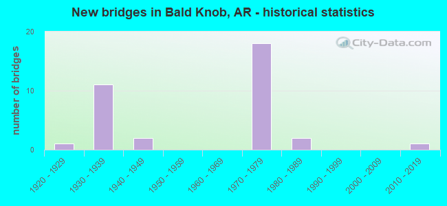
- New bridges - historical statistics
- 11920-1929
- 111930-1939
- 21940-1949
- 181970-1979
- 21980-1989
- 12010-2019
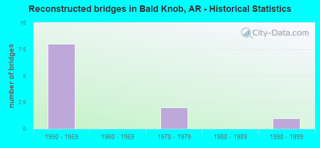
- Reconstructed bridges - Historical Statistics
- 81950-1959
- 01960-1969
- 21970-1979
- 01980-1989
- 11990-1999

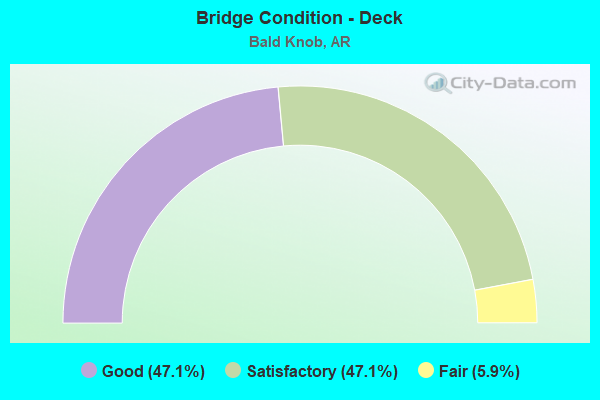
- Bridge Condition - Deck
- 47.1%Good
- 47.1%Satisfactory
- 5.9%Fair
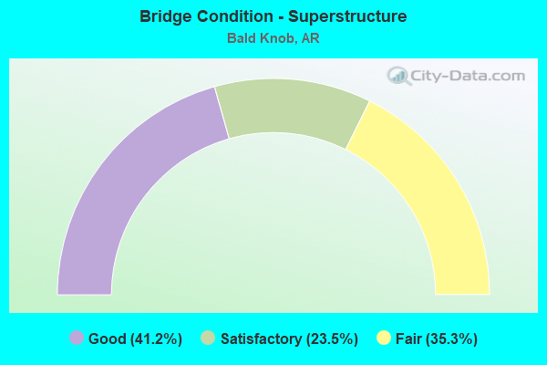
- Bridge Condition - Superstructure
- 41.2%Good
- 23.5%Satisfactory
- 35.3%Fair
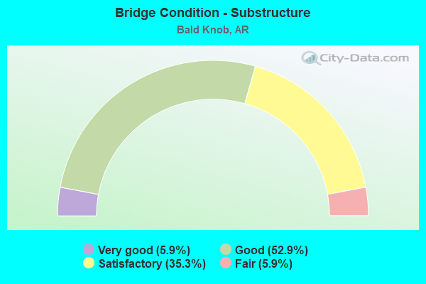
- Bridge Condition - Substructure
- 5.9%Very good
- 52.9%Good
- 35.3%Satisfactory
- 5.9%Fair
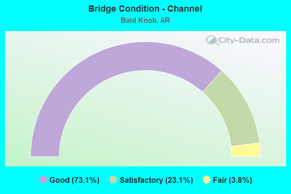
- Bridge Condition - Channel
- 73.1%Good
- 23.1%Satisfactory
- 3.8%Fair
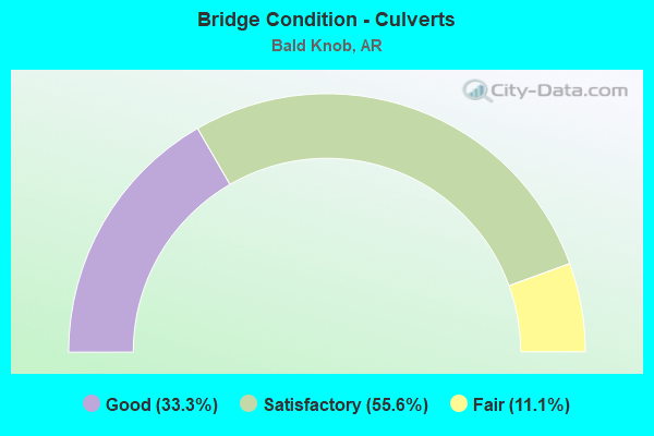
- Bridge Condition - Culverts
- 33.3%Good
- 55.6%Satisfactory
- 11.1%Fair
Find on map >> Show street view
Structure Number: 1414, Location: 1.60 NE JCT OF SH 323 (Lat: 35.296419, Lng: -91.599800), Route carried "on" structure: State highway 367, Year Built: 1930, Status: Open, Structure Length: 4.57m (14.99ft), Average Daily Traffic: 4,800 (year 2018), Truck Traffic: 1%, Average Future Daily Traffic: 8,131 (year 2028), Design Load: H 15, Features Intersected: OVERFLOW CREEK
Minimum Vertical Clearance: 30+ m (98+ ft), Kilometerpoint: 9.397, Lanes on structure: 2, Owner: State Highway Agency, Approaching Roadway Width: 7.9m (25.9ft), Skew: 4 degrees, Material/Design: Concrete continuous, Design/Construction: Tee Beam, Number Of Spans In Main Unit: 3, Length of Maximum Span: 18.3m (60.0ft), Curb or Sidewalk Widths: Left: 0.5m (1.6ft), Right: 0.5m (1.6ft), Curb-To-Curb Width: 7.3m (24.0ft), Out-to-Out Width: 8.3m (27.2ft)
Condition: Deck: Satisfactory, Superstructure: Satisfactory, Substructure: Satisfactory, Channel: Satisfactory, Operating Rating: 44.5 metric tons, Method Used To Determine Operating Rating: Load Factor (LF), Inventory Rating: 26.3 metric tons, Method Used To Determine Inventory Rating: Load Factor (LF), Structural Evaluation: Equal to present minimum criteria, Deck Geometry: High priority of replacement, Waterway Adequacy: Equal to present desirable criteria, Approach Roadway Alignment: Better than present minimum criteria, Length Of Structure Improvement: 5.49m (18.01ft), Designated Inspection Frequency: Every 24 months, Critical Feature Inspection Frequency: Every 24 months, Inspection Date: April 2020, Roadway Improvement Cost: $125,000, Total Project Cost: $456,000, Deck Structure Type: Concrete Cast-file-Place, Wearing Surface/Protective System: Wearing Surface: Bituminous
Find on map >> Show street view
Structure Number: 2111, Location: 2.54 MI N Jct US 67 (Lat: 35.355889, Lng: -91.564147), Route carried "on" structure: US 167, Year Built: 1987, Year Reconstructed: 1990, Status: Open, Structure Length: 1.62m (5.31ft), Average Daily Traffic: 8,400 (year 2018), Truck Traffic: 1%, Average Future Daily Traffic: 10,164 (year 2028), Design Load: HS 20, Features Intersected: OVER FLOW CREEK
Minimum Vertical Clearance: 30+ m (98+ ft), Kilometerpoint: 4.088, Lanes on structure: 4, Base Highway Network: Yes, Owner: State Highway Agency, Approaching Roadway Width: 21.9m (71.9ft), Skew: 23 degrees, Material/Design: Steel, Design/Construction: Stringer/Multi-beam, Number Of Spans In Main Unit: 1, Length of Maximum Span: 15.2m (49.9ft), Curb-To-Curb Width: 21.9m (71.9ft), Out-to-Out Width: 22.6m (74.1ft)
Condition: Deck: Satisfactory, Superstructure: Good, Substructure: Satisfactory, Channel: Satisfactory, Operating Rating: 54.4 metric tons, Method Used To Determine Operating Rating: Load Factor (LF), Inventory Rating: 32.7 metric tons, Method Used To Determine Inventory Rating: Load Factor (LF), Structural Evaluation: Equal to present minimum criteria, Deck Geometry: Superior to present desirable criteria, Waterway Adequacy: Equal to present desirable criteria, Approach Roadway Alignment: Equal to present desirable criteria, Designated Inspection Frequency: Every 24 months, Critical Feature Inspection Frequency: Every 24 months, Inspection Date: May 2020, Deck Structure Type: Concrete Cast-file-Place, Wearing Surface/Protective System: Wearing Surface: Monolithic Concrete
Find on map >> Show street view
Structure Number: 569, Location: JCT 258 & US 67 (Lat: 35.324889, Lng: -91.541461), Route carried "on" structure: State highway 258, Year Built: 1978, Status: Open, Structure Length: 10.42m (34.19ft), Average Daily Traffic: 220 (year 2018), Truck Traffic: 1%, Average Future Daily Traffic: 352 (year 2028), Design Load: HS 20, Features Intersected: US 67
Minimum Vertical Clearance: 30+ m (98+ ft), Kilometerpoint: 1.497, Lanes on structure: 2, Lanes under structure: 4, Owner: State Highway Agency, Approaching Roadway Width: 8.5m (27.9ft), Skew: 3 degrees, Material/Design: Steel continuous, Design/Construction: Stringer/Multi-beam, Number Of Spans In Main Unit: 4, Length of Maximum Span: 31.4m (103.0ft), Curb-To-Curb Width: 8.5m (27.9ft), Out-to-Out Width: 9.4m (30.8ft)
Condition: Deck: Satisfactory, Superstructure: Good, Substructure: Satisfactory, Operating Rating: 51.7 metric tons, Method Used To Determine Operating Rating: Load Factor (LF), Inventory Rating: 30.8 metric tons, Method Used To Determine Inventory Rating: Load Factor (LF), Structural Evaluation: Equal to present minimum criteria, Deck Geometry: Equal to present minimum criteria, Underclear: Better than present minimum criteria, Approach Roadway Alignment: Equal to present desirable criteria, Designated Inspection Frequency: Every 24 months, Critical Feature Inspection Frequency: Every 24 months, Inspection Date: April 2020, Deck Structure Type: Concrete Cast-file-Place, Wearing Surface/Protective System: Wearing Surface: Monolithic Concrete
Find on map >> Show street view
Structure Number: 5691, Location: 2.51 MI NE JCT US 167 (Lat: 35.339511, Lng: -91.530311), Route carried "on" structure: County highway 236, Year Built: 1978, Status: Open, Structure Length: 9.78m (32.09ft), Average Daily Traffic: 13 (year 1987), Truck Traffic: 1%, Average Future Daily Traffic: 75 (year 2007), Design Load: HS 20, Features Intersected: US 67-13-11.68
Minimum Vertical Clearance: 30+ m (98+ ft), Kilometerpoint: 18.792, Lanes on structure: 2, Lanes under structure: 4, Owner: State Highway Agency, Approaching Roadway Width: 8.5m (27.9ft), Skew: 3 degrees, Material/Design: Steel continuous, Design/Construction: Stringer/Multi-beam, Number Of Spans In Main Unit: 4, Length of Maximum Span: 31.4m (103.0ft), Curb-To-Curb Width: 8.5m (27.9ft), Out-to-Out Width: 9.4m (30.8ft)
Condition: Deck: Good, Superstructure: Good, Substructure: Good, Operating Rating: 48.1 metric tons, Method Used To Determine Operating Rating: Load Factor (LF), Inventory Rating: 29.0 metric tons, Method Used To Determine Inventory Rating: Load Factor (LF), Structural Evaluation: Better than present minimum criteria, Deck Geometry: Better than present minimum criteria, Underclear: Better than present minimum criteria, Approach Roadway Alignment: Equal to present desirable criteria, Designated Inspection Frequency: Every 24 months, Critical Feature Inspection Frequency: Every 24 months, Inspection Date: July 2021, Deck Structure Type: Concrete Cast-file-Place, Wearing Surface/Protective System: Wearing Surface: Monolithic Concrete
Find on map >> Show street view
Structure Number: 6036, Location: 1.54 MI W JCT SH 167 (Lat: 35.326589, Lng: -91.589281), Route carried "on" structure: State highway 258, Year Built: 1986, Status: Open, Structure Length: 3.20m (10.50ft), Average Daily Traffic: 820 (year 2018), Truck Traffic: 3%, Average Future Daily Traffic: 1,003 (year 2028), Design Load: HS 20, Features Intersected: OVERFLOW CREEK
Minimum Vertical Clearance: 30+ m (98+ ft), Kilometerpoint: 2.478, Lanes on structure: 2, Owner: State Highway Agency, Approaching Roadway Width: 9.1m (29.9ft), Material/Design: Concrete, Design/Construction: Slab, Number Of Spans In Main Unit: 3, Length of Maximum Span: 10.7m (35.1ft), Curb-To-Curb Width: 9.1m (29.9ft), Out-to-Out Width: 10.0m (32.8ft)
Condition: Deck: Good, Superstructure: Good, Substructure: Satisfactory, Channel: Good, Operating Rating: 54.4 metric tons, Method Used To Determine Operating Rating: Load Factor (LF), Inventory Rating: 32.7 metric tons, Method Used To Determine Inventory Rating: Load Factor (LF), Structural Evaluation: Equal to present minimum criteria, Deck Geometry: Equal to present minimum criteria, Waterway Adequacy: Equal to present desirable criteria, Approach Roadway Alignment: Equal to present desirable criteria, Designated Inspection Frequency: Every 24 months, Critical Feature Inspection Frequency: Every 24 months, Inspection Date: Febuary 2022, Deck Structure Type: Concrete Cast-file-Place, Wearing Surface/Protective System: Wearing Surface: Monolithic Concrete
Find on map >> Show street view
Structure Number: 17502, Location: JCT Collins & Ditch 13 Rd (Lat: 35.296214, Lng: -91.552133), Route carried "on" structure: County highway 96, Year Built: 1940, Status: Open, Structure Length: 0.73m (2.40ft), Average Daily Traffic: 38 (year 1987), Truck Traffic: 1%, Average Future Daily Traffic: 51 (year 2007), Features Intersected: DITCH
Minimum Vertical Clearance: 30+ m (98+ ft), Kilometerpoint: 2.961, Lanes on structure: 2, Owner: County Highway Agency, Approaching Roadway Width: 6.4m (21.0ft), Material/Design: Concrete, Design/Construction: Culvert, Number Of Spans In Main Unit: 5, Length of Maximum Span: 1.2m (3.9ft), Curb-To-Curb Width: 7.4m (24.3ft), Out-to-Out Width: 8.0m (26.2ft)
Condition: Channel: Satisfactory, Culverts: Fair, Operating Rating: 33.6 metric tons, Method Used To Determine Operating Rating: Load Factor (LF), Inventory Rating: 20.0 metric tons, Method Used To Determine Inventory Rating: Load Factor (LF), Structural Evaluation: Somewhat better than minimum adequacy, Deck Geometry: Equal to present minimum criteria, Waterway Adequacy: Better than present minimum criteria, Approach Roadway Alignment: Equal to present minimum criteria, Designated Inspection Frequency: Every 24 months, Critical Feature Inspection Frequency: Every 24 months, Inspection Date: March 2021, Wearing Surface/Protective System: Wearing Surface: Gravel
Find on map >> Show street view
Structure Number: 1755, Location: .9 E JCT US 167 (Lat: 35.339261, Lng: -91.546339), Route carried "on" structure: County highway 306, Year Built: 1925, Status: Open, Structure Length: 1.46m (4.79ft), Average Daily Traffic: 567 (year 2018), Truck Traffic: 1%, Average Future Daily Traffic: 213 (year 2007), Features Intersected: BIG MINGO
Minimum Vertical Clearance: 30+ m (98+ ft), Kilometerpoint: 4.311, Lanes on structure: 2, Owner: County Highway Agency, Approaching Roadway Width: 6.4m (21.0ft), Material/Design: Concrete, Design/Construction: Slab, Number Of Spans In Main Unit: 3, Length of Maximum Span: 4.9m (16.1ft), Curb or Sidewalk Widths: Left: 0.4m (1.3ft), Right: 0.4m (1.3ft), Curb-To-Curb Width: 4.9m (16.1ft), Out-to-Out Width: 5.6m (18.4ft)
Condition: Deck: Fair, Superstructure: Fair, Substructure: Fair, Channel: Fair, Operating Rating: 31.8 metric tons, Method Used To Determine Operating Rating: Load Factor (LF), Inventory Rating: 19.1 metric tons, Method Used To Determine Inventory Rating: Load Factor (LF), Structural Evaluation: Somewhat better than minimum adequacy, Deck Geometry: High priority of replacement, Waterway Adequacy: Equal to present minimum criteria, Approach Roadway Alignment: Equal to present minimum criteria, Length Of Structure Improvement: 2.19m (7.19ft), Designated Inspection Frequency: Every 24 months, Critical Feature Inspection Frequency: Every 24 months, Inspection Date: December 2021, Roadway Improvement Cost: $109,000, Total Project Cost: $240,000, Deck Structure Type: Concrete Cast-file-Place, Wearing Surface/Protective System: Wearing Surface: Bituminous
Find on map >> Show street view
Structure Number: 23266, Location: 0.6M N CORD381 & SH367 (Lat: 35.301939, Lng: -91.606567), Route carried "on" structure: County highway 381, Year Built: 2010, Status: Open, Structure Length: 1.62m (5.31ft), Average Daily Traffic: 157 (year 2018), Truck Traffic: 1%, Average Future Daily Traffic: 94 (year 2028), Features Intersected: FLAT CREEK
Minimum Vertical Clearance: 30+ m (98+ ft), Kilometerpoint: 0.966, Lanes on structure: 2, Owner: County Highway Agency, Approaching Roadway Width: 5.8m (19.0ft), Material/Design: Steel, Design/Construction: Culvert, Number Of Spans In Main Unit: 5, Length of Maximum Span: 2.7m (8.9ft)
Condition: Channel: Good, Culverts: Good, Operating Rating: 38.1 metric tons, Method Used To Determine Operating Rating: Load Factor (LF), Inventory Rating: 22.7 metric tons, Method Used To Determine Inventory Rating: Load Factor (LF), Structural Evaluation: Equal to present minimum criteria, Waterway Adequacy: Better than present minimum criteria, Approach Roadway Alignment: Somewhat better than minimum adequacy, Designated Inspection Frequency: Every 24 months, Critical Feature Inspection Frequency: Every 24 months, Inspection Date: May 2020, Wearing Surface/Protective System: Wearing Surface: Monolithic Concrete
Find on map >> Show street view
Structure Number: A1327, Location: 2.3 MI E JCT SH 367&US64 (Lat: 35.302061, Lng: -91.530800), Route carried "on" structure: US 64, Year Built: 1930, Year Reconstructed: 1962, Status: Open, Structure Length: 3.11m (10.20ft), Average Daily Traffic: 5,200 (year 2018), Truck Traffic: 14%, Average Future Daily Traffic: 7,700 (year 2033), Design Load: H 20, Features Intersected: BIG MINGO CREEK
Minimum Vertical Clearance: 30+ m (98+ ft), Kilometerpoint: 3.750, Lanes on structure: 2, Base Highway Network: Yes, Owner: State Highway Agency, Approaching Roadway Width: 9.4m (30.8ft), Material/Design: Concrete, Design/Construction: Tee Beam, Number Of Spans In Main Unit: 3, Length of Maximum Span: 10.4m (34.1ft), Curb or Sidewalk Widths: Left: 0.5m (1.6ft), Right: 0.5m (1.6ft), Curb-To-Curb Width: 8.5m (27.9ft), Out-to-Out Width: 9.5m (31.2ft)
Condition: Deck: Satisfactory, Superstructure: Satisfactory, Substructure: Good, Channel: Good, Operating Rating: 50.8 metric tons, Method Used To Determine Operating Rating: Load Factor (LF), Inventory Rating: 30.8 metric tons, Method Used To Determine Inventory Rating: Load Factor (LF), Structural Evaluation: Equal to present minimum criteria, Deck Geometry: High priority of replacement, Waterway Adequacy: Equal to present desirable criteria, Approach Roadway Alignment: Equal to present desirable criteria, Length Of Structure Improvement: 3.93m (12.89ft), Designated Inspection Frequency: Every 24 months, Critical Feature Inspection Frequency: Every 24 months, Inspection Date: May 2020, Roadway Improvement Cost: $265,000, Total Project Cost: $777,000, Deck Structure Type: Concrete Cast-file-Place, Wearing Surface/Protective System: Wearing Surface: Bituminous
Find on map >> Show street view
Structure Number: A1328, Location: 3.89 MI E JCT US 67 (Lat: 35.296761, Lng: -91.503961), Route carried "on" structure: US 64, Year Built: 1930, Year Reconstructed: 1962, Status: Open, Structure Length: 3.11m (10.20ft), Average Daily Traffic: 5,200 (year 2018), Truck Traffic: 14%, Average Future Daily Traffic: 7,700 (year 2033), Design Load: H 20, Features Intersected: LITTLE MINGO CREEK
Minimum Vertical Clearance: 30+ m (98+ ft), Kilometerpoint: 6.260, Lanes on structure: 2, Base Highway Network: Yes, Owner: State Highway Agency, Approaching Roadway Width: 12.8m (42.0ft), Material/Design: Concrete, Design/Construction: Tee Beam, Number Of Spans In Main Unit: 3, Length of Maximum Span: 10.4m (34.1ft), Curb or Sidewalk Widths: Left: 0.5m (1.6ft), Right: 0.5m (1.6ft), Curb-To-Curb Width: 8.5m (27.9ft), Out-to-Out Width: 9.4m (30.8ft)
Condition: Deck: Good, Superstructure: Good, Substructure: Good, Channel: Good, Operating Rating: 44.5 metric tons, Method Used To Determine Operating Rating: Load Factor (LF), Inventory Rating: 27.2 metric tons, Method Used To Determine Inventory Rating: Load Factor (LF), Structural Evaluation: Equal to present minimum criteria, Deck Geometry: High priority of replacement, Waterway Adequacy: Equal to present desirable criteria, Approach Roadway Alignment: Equal to present desirable criteria, Length Of Structure Improvement: 3.93m (12.89ft), Designated Inspection Frequency: Every 24 months, Critical Feature Inspection Frequency: Every 24 months, Inspection Date: August 2021, Roadway Improvement Cost: $265,000, Total Project Cost: $776,000, Deck Structure Type: Concrete Cast-file-Place, Wearing Surface/Protective System: Wearing Surface: Bituminous
Find on map >> Show street view
Structure Number: A1922, Location: 0.19 M E JCT SH 367&US64 (Lat: 35.313050, Lng: -91.562769), Route carried "on" structure: US 64, Year Built: 1935, Year Reconstructed: 1962, Status: Open, Structure Length: 7.01m (23.00ft), Average Daily Traffic: 5,200 (year 2018), Truck Traffic: 14%, Average Future Daily Traffic: 7,700 (year 2033), Design Load: H 20, Features Intersected: Grubbs Rd. & UPRR
Minimum Vertical Clearance: 30+ m (98+ ft), Kilometerpoint: 0.853, Lanes on structure: 2, Lanes under structure: 2, Base Highway Network: Yes, Owner: State Highway Agency, Approaching Roadway Width: 9.1m (29.9ft), Material/Design: Concrete, Design/Construction: Tee Beam, Number Of Spans In Main Unit: 1, Number Of Approach Spans: 4, Length of Maximum Span: 15.7m (51.5ft), Curb or Sidewalk Widths: Left: 0.5m (1.6ft), Right: 0.5m (1.6ft), Curb-To-Curb Width: 8.5m (27.9ft), Out-to-Out Width: 9.4m (30.8ft)
Condition: Deck: Satisfactory, Superstructure: Fair, Substructure: Satisfactory, Operating Rating: 40.8 metric tons, Method Used To Determine Operating Rating: Load Factor (LF), Inventory Rating: 24.5 metric tons, Method Used To Determine Inventory Rating: Load Factor (LF), Structural Evaluation: Somewhat better than minimum adequacy, Deck Geometry: Meets minimum limits, Underclear: Meets minimum limits, Approach Roadway Alignment: Better than present minimum criteria, Designated Inspection Frequency: Every 24 months, Critical Feature Inspection Frequency: Every 24 months, Inspection Date: October 2021, Deck Structure Type: Concrete Cast-file-Place, Wearing Surface/Protective System: Wearing Surface: Monolithic Concrete
Find on map >> Show street view
Structure Number: A5569, Location: 1.78 M W JCT US 167 (Lat: 35.320308, Lng: -91.590678), Route carried "on" structure: US 67, Year Built: 1974, Status: Open, Structure Length: 4.63m (15.19ft), Average Daily Traffic: 10,500 (year 2018), Truck Traffic: 1%, Average Future Daily Traffic: 11,519 (year 2028), Design Load: HS 20, Features Intersected: OVERFLOW CREEK
Minimum Vertical Clearance: 30+ m (98+ ft), Kilometerpoint: 12.086, Lanes on structure: 2, Base Highway Network: Yes, Owner: State Highway Agency, Approaching Roadway Width: 11.6m (38.1ft), Skew: 2 degrees, Material/Design: Steel, Design/Construction: Stringer/Multi-beam, Number Of Spans In Main Unit: 3, Length of Maximum Span: 15.2m (49.9ft), Curb-To-Curb Width: 11.9m (39.0ft), Out-to-Out Width: 12.8m (42.0ft)
Condition: Deck: Good, Superstructure: Good, Substructure: Good, Channel: Good, Operating Rating: 54.4 metric tons, Method Used To Determine Operating Rating: Load Factor (LF), Inventory Rating: 32.7 metric tons, Method Used To Determine Inventory Rating: Load Factor (LF), Structural Evaluation: Better than present minimum criteria, Deck Geometry: Better than present minimum criteria, Waterway Adequacy: Equal to present desirable criteria, Approach Roadway Alignment: Equal to present desirable criteria, Designated Inspection Frequency: Every 24 months, Critical Feature Inspection Frequency: Every 24 months, Inspection Date: June 2020, Deck Structure Type: Concrete Cast-file-Place, Wearing Surface/Protective System: Wearing Surface: Monolithic Concrete
Find on map >> Show street view
Structure Number: A557, Location: 1.14 M W JCT US 167 (Lat: 35.320261, Lng: -91.579581), Route carried "on" structure: US 67, Year Built: 1974, Status: Open, Structure Length: 2.74m (8.99ft), Average Daily Traffic: 10,500 (year 2018), Truck Traffic: 1%, Average Future Daily Traffic: 10,841 (year 2028), Design Load: HS 20, Features Intersected: CR 71 WHITE
Minimum Vertical Clearance: 30+ m (98+ ft), Kilometerpoint: 13.100, Lanes on structure: 2, Lanes under structure: 2, Base Highway Network: Yes, Owner: State Highway Agency, Approaching Roadway Width: 11.6m (38.1ft), Material/Design: Steel, Design/Construction: Box Beam or Girders - Multiple, Number Of Spans In Main Unit: 1, Length of Maximum Span: 26.8m (87.9ft), Curb or Sidewalk Widths: Left: 0.2m (0.7ft), Right: 0.2m (0.7ft), Curb-To-Curb Width: 11.9m (39.0ft), Out-to-Out Width: 12.8m (42.0ft)
Condition: Deck: Good, Superstructure: Fair, Substructure: Very good, Operating Rating: 54.4 metric tons, Method Used To Determine Operating Rating: Load Factor (LF), Inventory Rating: 32.7 metric tons, Method Used To Determine Inventory Rating: Load Factor (LF), Structural Evaluation: Somewhat better than minimum adequacy, Deck Geometry: Better than present minimum criteria, Underclear: Superior to present desirable criteria, Approach Roadway Alignment: Equal to present desirable criteria, Length Of Structure Improvement: 2.74m (8.99ft), Designated Inspection Frequency: Every 24 months, Critical Feature Inspection Frequency: Every 24 months, Inspection Date: May 2020, Total Project Cost: $170,000, Deck Structure Type: Concrete Cast-file-Place, Wearing Surface/Protective System: Wearing Surface: Monolithic Concrete
Find on map >> Show street view
Structure Number: A5688, Location: JCT US 67/167/64 (Lat: 35.319769, Lng: -91.561881), Route carried "on" structure: US 67, Year Built: 1978, Status: Open, Structure Length: 3.87m (12.70ft), Average Daily Traffic: 9,402 (year 2018), Truck Traffic: 1%, Average Future Daily Traffic: 10,841 (year 2028), Design Load: HS 20, Features Intersected: US 167 Sec 14
Minimum Vertical Clearance: 30+ m (98+ ft), Kilometerpoint: 14.709, Lanes on structure: 2, Lanes under structure: 4, Base Highway Network: Yes, Owner: State Highway Agency, Approaching Roadway Width: 11.6m (38.1ft), Material/Design: Steel, Design/Construction: Box Beam or Girders - Multiple, Number Of Spans In Main Unit: 1, Length of Maximum Span: 38.1m (125.0ft), Curb-To-Curb Width: 12.2m (40.0ft), Out-to-Out Width: 13.0m (42.7ft)
Condition: Deck: Good, Superstructure: Fair, Substructure: Good, Operating Rating: 34.5 metric tons, Method Used To Determine Operating Rating: Load Factor (LF), Inventory Rating: 20.9 metric tons, Method Used To Determine Inventory Rating: Load Factor (LF), Structural Evaluation: Somewhat better than minimum adequacy, Deck Geometry: Better than present minimum criteria, Underclear: Better than present minimum criteria, Approach Roadway Alignment: Equal to present desirable criteria, Length Of Structure Improvement: 3.87m (12.70ft), Designated Inspection Frequency: Every 24 months, Critical Feature Inspection Frequency: Every 24 months, Inspection Date: May 2020, Total Project Cost: $243,000, Deck Structure Type: Concrete Cast-file-Place, Wearing Surface/Protective System: Wearing Surface: Epoxy Overlay
Find on map >> Show street view
Structure Number: A5689, Location: .34 MI NE OF JCT 167 (Lat: 35.319600, Lng: -91.555511), Route carried "on" structure: US 67, Year Built: 1978, Status: Open, Structure Length: 7.47m (24.51ft), Average Daily Traffic: 5,500 (year 2018), Truck Traffic: 1%, Average Future Daily Traffic: 5,421 (year 2028), Design Load: HS 20, Features Intersected: UPRR&GRUBBS RD
Minimum Vertical Clearance: 30+ m (98+ ft), Kilometerpoint: 15.289, Lanes on structure: 2, Lanes under structure: 1, Base Highway Network: Yes, Owner: State Highway Agency, Approaching Roadway Width: 11.6m (38.1ft), Skew: 3 degrees, Material/Design: Steel continuous, Design/Construction: Stringer/Multi-beam, Number Of Spans In Main Unit: 3, Length of Maximum Span: 34.7m (113.8ft), Curb-To-Curb Width: 12.2m (40.0ft), Out-to-Out Width: 13.0m (42.7ft)
Condition: Deck: Satisfactory, Superstructure: Satisfactory, Substructure: Good, Operating Rating: 54.4 metric tons, Method Used To Determine Operating Rating: Load Factor (LF), Inventory Rating: 32.7 metric tons, Method Used To Determine Inventory Rating: Load Factor (LF), Structural Evaluation: Equal to present minimum criteria, Deck Geometry: Better than present minimum criteria, Underclear: High priority of corrective action, Approach Roadway Alignment: Equal to present desirable criteria, Designated Inspection Frequency: Every 24 months, Critical Feature Inspection Frequency: Every 24 months, Inspection Date: April 2020, Deck Structure Type: Concrete Cast-file-Place, Wearing Surface/Protective System: Wearing Surface: Epoxy Overlay
Find on map >> Show street view
Structure Number: B5569, Location: 1.78 MI W JCT US 167 (Lat: 35.320058, Lng: -91.590808), Route carried "on" structure: US 67, Year Built: 1974, Status: Open, Structure Length: 4.63m (15.19ft), Average Daily Traffic: 10,500 (year 2018), Truck Traffic: 17%, Average Future Daily Traffic: 27,300 (year 2038), Design Load: HS 20, Features Intersected: OVERFLOW CREEK
Minimum Vertical Clearance: 30+ m (98+ ft), Kilometerpoint: 12.086, Lanes on structure: 2, Base Highway Network: Yes, Owner: State Highway Agency, Approaching Roadway Width: 11.6m (38.1ft), Skew: 3 degrees, Material/Design: Steel, Design/Construction: Stringer/Multi-beam, Number Of Spans In Main Unit: 3, Length of Maximum Span: 15.2m (49.9ft), Curb or Sidewalk Widths: Left: 0.1m (0.3ft), Right: 0.1m (0.3ft), Curb-To-Curb Width: 11.9m (39.0ft), Out-to-Out Width: 12.8m (42.0ft)
Condition: Deck: Good, Superstructure: Good, Substructure: Good, Channel: Good, Operating Rating: 54.4 metric tons, Method Used To Determine Operating Rating: Load Factor (LF), Inventory Rating: 32.7 metric tons, Method Used To Determine Inventory Rating: Load Factor (LF), Structural Evaluation: Better than present minimum criteria, Deck Geometry: Better than present minimum criteria, Waterway Adequacy: Equal to present desirable criteria, Approach Roadway Alignment: Equal to present desirable criteria, Designated Inspection Frequency: Every 24 months, Critical Feature Inspection Frequency: Every 24 months, Inspection Date: June 2020, Deck Structure Type: Concrete Cast-file-Place, Wearing Surface/Protective System: Wearing Surface: Monolithic Concrete
Find on map >> Show street view
Structure Number: B557, Location: 1.14 MI W JCT US 167 (Lat: 35.320019, Lng: -91.579600), Route carried "on" structure: US 67, Year Built: 1974, Status: Open, Structure Length: 2.74m (8.99ft), Average Daily Traffic: 10,500 (year 2018), Truck Traffic: 18%, Average Future Daily Traffic: 27,300 (year 2038), Design Load: HS 20, Features Intersected: CO RD 71
Minimum Vertical Clearance: 30+ m (98+ ft), Kilometerpoint: 13.100, Lanes on structure: 2, Lanes under structure: 2, Base Highway Network: Yes, Owner: State Highway Agency, Approaching Roadway Width: 11.6m (38.1ft), Material/Design: Steel, Design/Construction: Box Beam or Girders - Multiple, Number Of Spans In Main Unit: 1, Length of Maximum Span: 26.8m (87.9ft), Curb or Sidewalk Widths: Left: 0.2m (0.7ft), Right: 0.2m (0.7ft), Curb-To-Curb Width: 11.9m (39.0ft), Out-to-Out Width: 12.8m (42.0ft)
Condition: Deck: Satisfactory, Superstructure: Fair, Substructure: Good, Operating Rating: 54.4 metric tons, Method Used To Determine Operating Rating: Load Factor (LF), Inventory Rating: 32.7 metric tons, Method Used To Determine Inventory Rating: Load Factor (LF), Structural Evaluation: Somewhat better than minimum adequacy, Deck Geometry: Better than present minimum criteria, Underclear: Better than present minimum criteria, Approach Roadway Alignment: Equal to present desirable criteria, Length Of Structure Improvement: 2.74m (8.99ft), Designated Inspection Frequency: Every 24 months, Critical Feature Inspection Frequency: Every 24 months, Inspection Date: May 2020, Total Project Cost: $170,000, Deck Structure Type: Concrete Cast-file-Place, Wearing Surface/Protective System: Wearing Surface: Monolithic Concrete
Find on map >> Show street view
Structure Number: B5688, Location: JCT US 67/167/64 (Lat: 35.319539, Lng: -91.561889), Route carried "on" structure: US 67, Year Built: 1978, Status: Open, Structure Length: 3.87m (12.70ft), Average Daily Traffic: 9,402 (year 2018), Truck Traffic: 18%, Average Future Daily Traffic: 24,700 (year 2038), Design Load: HS 20, Features Intersected: US 64-SEC 11
Minimum Vertical Clearance: 30+ m (98+ ft), Kilometerpoint: 14.709, Lanes on structure: 2, Lanes under structure: 4, Base Highway Network: Yes, Owner: State Highway Agency, Approaching Roadway Width: 11.6m (38.1ft), Material/Design: Steel, Design/Construction: Box Beam or Girders - Multiple, Number Of Spans In Main Unit: 1, Length of Maximum Span: 38.1m (125.0ft), Curb-To-Curb Width: 12.2m (40.0ft), Out-to-Out Width: 13.0m (42.7ft)
Condition: Deck: Good, Superstructure: Fair, Substructure: Good, Operating Rating: 34.5 metric tons, Method Used To Determine Operating Rating: Load Factor (LF), Inventory Rating: 20.9 metric tons, Method Used To Determine Inventory Rating: Load Factor (LF), Structural Evaluation: Somewhat better than minimum adequacy, Deck Geometry: Better than present minimum criteria, Underclear: Better than present minimum criteria, Approach Roadway Alignment: Equal to present desirable criteria, Length Of Structure Improvement: 3.87m (12.70ft), Designated Inspection Frequency: Every 24 months, Critical Feature Inspection Frequency: Every 24 months, Inspection Date: May 2020, Total Project Cost: $243,000, Deck Structure Type: Concrete Cast-file-Place, Wearing Surface/Protective System: Wearing Surface: Epoxy Overlay
Find on map >> Show street view
Structure Number: B5689, Location: .34 MI NE OF JCT 167 (Lat: 35.319369, Lng: -91.555769), Route carried "on" structure: US 67, Year Built: 1978, Status: Open, Structure Length: 7.47m (24.51ft), Average Daily Traffic: 5,500 (year 2018), Truck Traffic: 33%, Average Future Daily Traffic: 14,300 (year 2038), Design Load: HS 20, Features Intersected: UPRR& Grubbs Rd
Minimum Vertical Clearance: 30+ m (98+ ft), Kilometerpoint: 15.273, Lanes on structure: 2, Lanes under structure: 1, Base Highway Network: Yes, Owner: State Highway Agency, Approaching Roadway Width: 14.0m (45.9ft), Skew: 3 degrees, Material/Design: Steel continuous, Design/Construction: Stringer/Multi-beam, Number Of Spans In Main Unit: 3, Length of Maximum Span: 34.7m (113.8ft), Curb-To-Curb Width: 14.6m (47.9ft), Out-to-Out Width: 15.5m (50.9ft)
Condition: Deck: Satisfactory, Superstructure: Satisfactory, Substructure: Satisfactory, Operating Rating: 54.4 metric tons, Method Used To Determine Operating Rating: Load Factor (LF), Inventory Rating: 32.7 metric tons, Method Used To Determine Inventory Rating: Load Factor (LF), Structural Evaluation: Equal to present minimum criteria, Deck Geometry: Superior to present desirable criteria, Underclear: High priority of corrective action, Approach Roadway Alignment: Equal to present desirable criteria, Designated Inspection Frequency: Every 24 months, Critical Feature Inspection Frequency: Every 24 months, Inspection Date: April 2020, Deck Structure Type: Concrete Cast-file-Place, Wearing Surface/Protective System: Wearing Surface: Epoxy Overlay
Find on map >> Show street view
Structure Number: M1164, Location: .4 M E JCT SH367&US64 (Lat: 35.309578, Lng: -91.558006), Route carried "on" structure: US 64, Year Built: 1930, Year Reconstructed: 1962, Status: Open, Structure Length: 0.64m (2.10ft), Average Daily Traffic: 5,200 (year 2018), Truck Traffic: 14%, Average Future Daily Traffic: 7,700 (year 2033), Design Load: H 20, Features Intersected: DITCH
Minimum Vertical Clearance: 30+ m (98+ ft), Kilometerpoint: 1.432, Lanes on structure: 2, Base Highway Network: Yes, Owner: State Highway Agency, Approaching Roadway Width: 12.2m (40.0ft), Material/Design: Concrete, Design/Construction: Culvert, Number Of Spans In Main Unit: 2, Length of Maximum Span: 3.0m (9.8ft)
Condition: Channel: Good, Culverts: Satisfactory, Operating Rating: 35.4 metric tons, Method Used To Determine Operating Rating: Load Factor (LF), Inventory Rating: 21.8 metric tons, Method Used To Determine Inventory Rating: Load Factor (LF), Structural Evaluation: Somewhat better than minimum adequacy, Waterway Adequacy: Equal to present desirable criteria, Approach Roadway Alignment: Equal to present desirable criteria, Designated Inspection Frequency: Every 24 months, Critical Feature Inspection Frequency: Every 24 months, Inspection Date: March 2020
Find on map >> Show street view
Structure Number: M1165, Location: 1.3 M E OF JCT SH367&US64 (Lat: 35.305269, Lng: -91.546689), Route carried "on" structure: US 64, Year Built: 1930, Year Reconstructed: 1962, Status: Open, Structure Length: 0.79m (2.59ft), Average Daily Traffic: 5,200 (year 2018), Truck Traffic: 14%, Average Future Daily Traffic: 7,700 (year 2033), Design Load: H 20, Features Intersected: DITCH
Minimum Vertical Clearance: 30+ m (98+ ft), Kilometerpoint: 2.591, Lanes on structure: 2, Base Highway Network: Yes, Owner: State Highway Agency, Approaching Roadway Width: 12.5m (41.0ft), Material/Design: Concrete, Design/Construction: Culvert, Number Of Spans In Main Unit: 3, Length of Maximum Span: 2.4m (7.9ft)
Condition: Channel: Good, Culverts: Satisfactory, Operating Rating: 42.6 metric tons, Method Used To Determine Operating Rating: Load Factor (LF), Inventory Rating: 25.4 metric tons, Method Used To Determine Inventory Rating: Load Factor (LF), Structural Evaluation: Equal to present minimum criteria, Waterway Adequacy: Equal to present desirable criteria, Approach Roadway Alignment: Equal to present desirable criteria, Designated Inspection Frequency: Every 24 months, Critical Feature Inspection Frequency: Every 24 months, Inspection Date: March 2020
Find on map >> Show street view
Structure Number: M1166, Location: 3.2 M E OF US 67 (Lat: 35.298639, Lng: -91.513219), Route carried "on" structure: US 64, Year Built: 1930, Year Reconstructed: 1962, Status: Open, Structure Length: 0.64m (2.10ft), Average Daily Traffic: 5,200 (year 2018), Truck Traffic: 14%, Average Future Daily Traffic: 7,700 (year 2033), Design Load: H 20, Features Intersected: DITCH
Minimum Vertical Clearance: 30+ m (98+ ft), Kilometerpoint: 5.729, Lanes on structure: 2, Base Highway Network: Yes, Owner: State Highway Agency, Approaching Roadway Width: 13.4m (44.0ft), Material/Design: Concrete, Design/Construction: Culvert, Number Of Spans In Main Unit: 2, Length of Maximum Span: 3.4m (11.2ft)
Condition: Channel: Good, Culverts: Satisfactory, Operating Rating: 42.6 metric tons, Method Used To Determine Operating Rating: Load Factor (LF), Inventory Rating: 25.4 metric tons, Method Used To Determine Inventory Rating: Load Factor (LF), Structural Evaluation: Equal to present minimum criteria, Waterway Adequacy: Equal to present desirable criteria, Approach Roadway Alignment: Equal to present desirable criteria, Designated Inspection Frequency: Every 24 months, Critical Feature Inspection Frequency: Every 24 months, Inspection Date: March 2021
Find on map >> Show street view
Structure Number: M1244, Location: .10 NE JCT SH 367 & US 67 (Lat: 35.317958, Lng: -91.561258), Route carried "on" structure: ServiceCounty highway 67, Year Built: 1930, Year Reconstructed: 1976, Status: Open, Structure Length: 1.31m (4.30ft), Average Daily Traffic: 260 (year 2014), Truck Traffic: 1%, Average Future Daily Traffic: 65 (year 2034), Design Load: H 15, Features Intersected: DITCH
Minimum Vertical Clearance: 30+ m (98+ ft), Kilometerpoint: 14.835, Lanes on structure: 2, Owner: State Highway Agency, Approaching Roadway Width: 6.7m (22.0ft), Material/Design: Concrete, Design/Construction: Culvert, Number Of Spans In Main Unit: 4, Length of Maximum Span: 3.0m (9.8ft)
Condition: Channel: Good, Culverts: Satisfactory, Operating Rating: 35.4 metric tons, Method Used To Determine Operating Rating: Load Factor (LF), Inventory Rating: 21.8 metric tons, Method Used To Determine Inventory Rating: Load Factor (LF), Structural Evaluation: Equal to present minimum criteria, Waterway Adequacy: Equal to present desirable criteria, Approach Roadway Alignment: Better than present minimum criteria, Designated Inspection Frequency: Every 24 months, Critical Feature Inspection Frequency: Every 24 months, Inspection Date: April 2020
Find on map >> Show street view
Structure Number: M1245, Location: 0.1 MI N JCT SH 258 SH367 (Lat: 35.326328, Lng: -91.548539), Route carried "on" structure: State highway 367, Year Built: 1930, Year Reconstructed: 1950, Status: Open, Structure Length: 0.64m (2.10ft), Average Daily Traffic: 1,500 (year 2018), Truck Traffic: 1%, Average Future Daily Traffic: 2,304 (year 2028), Design Load: H 15, Features Intersected: DITCH
Minimum Vertical Clearance: 30+ m (98+ ft), Kilometerpoint: 1.400, Lanes on structure: 2, Owner: State Highway Agency, Approaching Roadway Width: 13.1m (43.0ft), Material/Design: Concrete, Design/Construction: Culvert, Number Of Spans In Main Unit: 2, Length of Maximum Span: 3.0m (9.8ft)
Condition: Channel: Good, Culverts: Good, Operating Rating: 41.7 metric tons, Method Used To Determine Operating Rating: Load Factor (LF), Inventory Rating: 25.4 metric tons, Method Used To Determine Inventory Rating: Load Factor (LF), Structural Evaluation: Equal to present minimum criteria, Waterway Adequacy: Equal to present desirable criteria, Approach Roadway Alignment: Equal to present desirable criteria, Designated Inspection Frequency: Every 24 months, Critical Feature Inspection Frequency: Every 24 months, Inspection Date: May 2021
Find on map >> Show street view
Structure Number: M1246, Location: 0.1 MI N JCT SH 258 SH367 (Lat: 35.328019, Lng: -91.546550), Route carried "on" structure: State highway 367, Year Built: 1930, Year Reconstructed: 1958, Status: Open, Structure Length: 0.79m (2.59ft), Average Daily Traffic: 1,600 (year 2018), Truck Traffic: 1%, Average Future Daily Traffic: 2,168 (year 2028), Design Load: H 15, Features Intersected: BIG MINGO CREEK
Minimum Vertical Clearance: 30+ m (98+ ft), Kilometerpoint: 1.658, Lanes on structure: 2, Owner: State Highway Agency, Approaching Roadway Width: 13.4m (44.0ft), Material/Design: Concrete, Design/Construction: Culvert, Number Of Spans In Main Unit: 3, Length of Maximum Span: 2.4m (7.9ft)
Condition: Channel: Satisfactory, Culverts: Satisfactory, Operating Rating: 50.8 metric tons, Method Used To Determine Operating Rating: Load Factor (LF), Inventory Rating: 30.8 metric tons, Method Used To Determine Inventory Rating: Load Factor (LF), Structural Evaluation: Equal to present minimum criteria, Waterway Adequacy: Equal to present desirable criteria, Approach Roadway Alignment: Equal to present desirable criteria, Designated Inspection Frequency: Every 24 months, Critical Feature Inspection Frequency: Every 24 months, Inspection Date: December 2021
Find on map >> Show street view
Structure Number: M2186, Location: 0.10 MI N JCT US 67 & 167 (Lat: 35.318011, Lng: -91.561719), Route carried "on" structure: US 64, Year Built: 1939, Year Reconstructed: 1977, Status: Open, Structure Length: 1.83m (6.00ft), Average Daily Traffic: 12,000 (year 2018), Truck Traffic: 8%, Average Future Daily Traffic: 18,972 (year 2028), Design Load: H 15, Features Intersected: DITCH
Minimum Vertical Clearance: 30+ m (98+ ft), Kilometerpoint: 0.161, Lanes on structure: 2, Base Highway Network: Yes, Owner: State Highway Agency, Approaching Roadway Width: 10.4m (34.1ft), Skew: 4 degrees, Material/Design: Concrete, Design/Construction: Culvert, Number Of Spans In Main Unit: 4, Length of Maximum Span: 4.3m (14.1ft)
Condition: Channel: Good, Culverts: Satisfactory, Operating Rating: 39.9 metric tons, Method Used To Determine Operating Rating: Load Factor (LF), Inventory Rating: 23.6 metric tons, Method Used To Determine Inventory Rating: Load Factor (LF), Structural Evaluation: Somewhat better than minimum adequacy, Waterway Adequacy: Equal to present desirable criteria, Approach Roadway Alignment: Better than present minimum criteria, Designated Inspection Frequency: Every 24 months, Critical Feature Inspection Frequency: Every 24 months, Inspection Date: December 2021
Find on map >> Show street view
Structure Number: M2882, Location: 2.45 MI N JCT US 67 & 323 (Lat: 35.321281, Lng: -91.623919), Route carried "on" structure: State highway 323, Year Built: 1940, Status: Open, Structure Length: 0.79m (2.59ft), Average Daily Traffic: 940 (year 2018), Truck Traffic: 1%, Average Future Daily Traffic: 1,165 (year 2028), Design Load: H 10, Features Intersected: CREEK
Minimum Vertical Clearance: 30+ m (98+ ft), Kilometerpoint: 5.599, Lanes on structure: 2, Owner: State Highway Agency, Approaching Roadway Width: 7.6m (24.9ft), Material/Design: Concrete, Design/Construction: Culvert, Number Of Spans In Main Unit: 5, Length of Maximum Span: 1.2m (3.9ft)
Condition: Channel: Satisfactory, Culverts: Fair, Operating Rating: 33.6 metric tons, Method Used To Determine Operating Rating: Load Factor (LF), Inventory Rating: 20.0 metric tons, Method Used To Determine Inventory Rating: Load Factor (LF), Structural Evaluation: Somewhat better than minimum adequacy, Waterway Adequacy: Better than present minimum criteria, Approach Roadway Alignment: Better than present minimum criteria, Designated Inspection Frequency: Every 24 months, Critical Feature Inspection Frequency: Every 24 months, Inspection Date: August 2021
Find on map >> Show street view
Structure Number: X0313, Location: 0.78 MI N JCT SH 323 (Lat: 35.311028, Lng: -91.612539), Route carried "on" structure: US 67, Year Built: 1976, Status: Open, Structure Length: 0.73m (2.40ft), Average Daily Traffic: 21,000 (year 2018), Truck Traffic: 17%, Average Future Daily Traffic: 27,300 (year 2038), Design Load: H 20, Features Intersected: POWDER FORK
Minimum Vertical Clearance: 30+ m (98+ ft), Kilometerpoint: 9.910, Lanes on structure: 4, Base Highway Network: Yes, Owner: State Highway Agency, Approaching Roadway Width: 8.5m (27.9ft), Skew: 13 degrees, Material/Design: Concrete, Design/Construction: Culvert, Number Of Spans In Main Unit: 2, Length of Maximum Span: 3.7m (12.1ft)
Condition: Channel: Good, Culverts: Satisfactory, Operating Rating: 39.9 metric tons, Method Used To Determine Operating Rating: Load Factor (LF), Inventory Rating: 23.6 metric tons, Method Used To Determine Inventory Rating: Load Factor (LF), Structural Evaluation: Somewhat better than minimum adequacy, Waterway Adequacy: Equal to present desirable criteria, Approach Roadway Alignment: Equal to present desirable criteria, Designated Inspection Frequency: Every 24 months, Critical Feature Inspection Frequency: Every 24 months, Inspection Date: May 2020
Find on map >> Show street view
Structure Number: X0314, Location: 1.68 MI N JCT SH 323 (Lat: 35.317608, Lng: -91.598628), Route carried "on" structure: US 67, Year Built: 1974, Status: Open, Structure Length: 1.13m (3.71ft), Average Daily Traffic: 21,000 (year 2018), Truck Traffic: 17%, Average Future Daily Traffic: 27,300 (year 2038), Design Load: H 20, Features Intersected: DRAINAGE DITCH
Minimum Vertical Clearance: 30+ m (98+ ft), Kilometerpoint: 11.330, Lanes on structure: 4, Base Highway Network: Yes, Owner: State Highway Agency, Approaching Roadway Width: 8.5m (27.9ft), Skew: 13 degrees, Material/Design: Concrete, Design/Construction: Culvert, Number Of Spans In Main Unit: 3, Length of Maximum Span: 4.0m (13.1ft)
Condition: Channel: Satisfactory, Culverts: Satisfactory, Operating Rating: 39.9 metric tons, Method Used To Determine Operating Rating: Load Factor (LF), Inventory Rating: 23.6 metric tons, Method Used To Determine Inventory Rating: Load Factor (LF), Structural Evaluation: Somewhat better than minimum adequacy, Waterway Adequacy: Equal to present desirable criteria, Approach Roadway Alignment: Equal to present desirable criteria, Designated Inspection Frequency: Every 24 months, Critical Feature Inspection Frequency: Every 24 months, Inspection Date: April 2020
Find on map >> Show street view
Structure Number: X0315, Location: 0.1 MI S JCT US 167 (Lat: 35.318981, Lng: -91.563431), Route carried "on" structure: Ramp US 67, Year Built: 1976, Status: Open, Structure Length: 0.85m (2.79ft), Average Daily Traffic: 7,800 (year 2011), Truck Traffic: 1%, Average Future Daily Traffic: 2,750 (year 2028), Design Load: H 20, Features Intersected: DRAINAGE DITCH
Minimum Vertical Clearance: 30+ m (98+ ft), Kilometerpoint: 14.610, Lanes on structure: 1, Owner: State Highway Agency, Approaching Roadway Width: 8.2m (26.9ft), Skew: 4 degrees, Material/Design: Concrete, Design/Construction: Culvert, Number Of Spans In Main Unit: 3, Length of Maximum Span: 2.7m (8.9ft)
Condition: Channel: Good, Culverts: Good, Operating Rating: 38.1 metric tons, Method Used To Determine Operating Rating: Load Factor (LF), Inventory Rating: 22.7 metric tons, Method Used To Determine Inventory Rating: Load Factor (LF), Structural Evaluation: Somewhat better than minimum adequacy, Waterway Adequacy: Equal to present desirable criteria, Approach Roadway Alignment: Equal to present desirable criteria, Designated Inspection Frequency: Every 24 months, Critical Feature Inspection Frequency: Every 24 months, Inspection Date: July 2021
Find on map >> Show street view
Structure Number: X0316, Location: 0.1 MI S JCT US 167 (Lat: 35.320469, Lng: -91.563081), Route carried "on" structure: Ramp US 67, Year Built: 1976, Status: Open, Structure Length: 0.98m (3.22ft), Average Daily Traffic: 8,048 (year 2011), Truck Traffic: 1%, Average Future Daily Traffic: 2,750 (year 2028), Design Load: H 20, Features Intersected: DRAINAGE DITCH
Minimum Vertical Clearance: 30+ m (98+ ft), Kilometerpoint: 14.642, Lanes on structure: 1, Owner: State Highway Agency, Approaching Roadway Width: 8.2m (26.9ft), Material/Design: Concrete, Design/Construction: Culvert, Number Of Spans In Main Unit: 3, Length of Maximum Span: 3.4m (11.2ft)
Condition: Channel: Good, Culverts: Good, Operating Rating: 39.9 metric tons, Method Used To Determine Operating Rating: Load Factor (LF), Inventory Rating: 23.6 metric tons, Method Used To Determine Inventory Rating: Load Factor (LF), Structural Evaluation: Somewhat better than minimum adequacy, Waterway Adequacy: Equal to present desirable criteria, Approach Roadway Alignment: Equal to present desirable criteria, Designated Inspection Frequency: Every 24 months, Critical Feature Inspection Frequency: Every 24 months, Inspection Date: July 2021
Find on map >> Show street view
Structure Number: X0317, Location: 0.1 MI S JCT US 167 (Lat: 35.319547, Lng: -91.562519), Route carried "on" structure: US 67, Year Built: 1976, Status: Open, Structure Length: 1.13m (3.71ft), Average Daily Traffic: 18,804 (year 2018), Truck Traffic: 18%, Average Future Daily Traffic: 24,700 (year 2038), Design Load: H 20, Features Intersected: DRAINAGE DITCH
Minimum Vertical Clearance: 30+ m (98+ ft), Kilometerpoint: 14.645, Lanes on structure: 4, Base Highway Network: Yes, Owner: State Highway Agency, Approaching Roadway Width: 8.5m (27.9ft), Skew: 23 degrees, Material/Design: Concrete, Design/Construction: Culvert, Number Of Spans In Main Unit: 3, Length of Maximum Span: 3.7m (12.1ft)
Condition: Channel: Good, Culverts: Satisfactory, Operating Rating: 42.6 metric tons, Method Used To Determine Operating Rating: Load Factor (LF), Inventory Rating: 25.4 metric tons, Method Used To Determine Inventory Rating: Load Factor (LF), Structural Evaluation: Equal to present minimum criteria, Waterway Adequacy: Equal to present desirable criteria, Approach Roadway Alignment: Equal to present desirable criteria, Designated Inspection Frequency: Every 24 months, Critical Feature Inspection Frequency: Every 24 months, Inspection Date: April 2020
Find on map >> Show street view
Structure Number: X0437, Location: .86 NE JCT 167 (Lat: 35.320128, Lng: -91.546778), Route carried "on" structure: US 67, Year Built: 1978, Status: Open, Structure Length: 0.67m (2.20ft), Average Daily Traffic: 11,000 (year 2018), Truck Traffic: 33%, Average Future Daily Traffic: 14,300 (year 2038), Design Load: H 20, Features Intersected: DITCH
Minimum Vertical Clearance: 30+ m (98+ ft), Kilometerpoint: 16.110, Lanes on structure: 4, Base Highway Network: Yes, Owner: State Highway Agency, Approaching Roadway Width: 23.2m (76.1ft), Skew: 11 degrees, Material/Design: Concrete, Design/Construction: Culvert, Number Of Spans In Main Unit: 2, Length of Maximum Span: 3.4m (11.2ft)
Condition: Channel: Good, Culverts: Good, Operating Rating: 39.9 metric tons, Method Used To Determine Operating Rating: Load Factor (LF), Inventory Rating: 23.6 metric tons, Method Used To Determine Inventory Rating: Load Factor (LF), Structural Evaluation: Somewhat better than minimum adequacy, Waterway Adequacy: Equal to present desirable criteria, Approach Roadway Alignment: Equal to present desirable criteria, Designated Inspection Frequency: Every 24 months, Critical Feature Inspection Frequency: Every 24 months, Inspection Date: May 2020
Find on map >> Show street view
Structure Number: X0438, Location: 1.18 MI NE JCT 167 (Lat: 35.323478, Lng: -91.543069), Route carried "on" structure: US 67, Year Built: 1978, Status: Open, Structure Length: 1.89m (6.20ft), Average Daily Traffic: 11,000 (year 2018), Truck Traffic: 33%, Average Future Daily Traffic: 14,300 (year 2038), Design Load: H 20, Features Intersected: BIG MINGO CREEK
Minimum Vertical Clearance: 30+ m (98+ ft), Kilometerpoint: 16.625, Lanes on structure: 4, Base Highway Network: Yes, Owner: State Highway Agency, Approaching Roadway Width: 23.2m (76.1ft), Skew: 13 degrees, Material/Design: Concrete, Design/Construction: Culvert, Number Of Spans In Main Unit: 4, Length of Maximum Span: 4.3m (14.1ft)
Condition: Channel: Good, Culverts: Satisfactory, Operating Rating: 31.8 metric tons, Method Used To Determine Operating Rating: Load Factor (LF), Inventory Rating: 19.1 metric tons, Method Used To Determine Inventory Rating: Load Factor (LF), Structural Evaluation: Meets minimum limits, Waterway Adequacy: Equal to present desirable criteria, Approach Roadway Alignment: Equal to present desirable criteria, Designated Inspection Frequency: Every 24 months, Critical Feature Inspection Frequency: Every 24 months, Inspection Date: July 2020
Find on map >> Show street view
Structure Number: X0441, Location: .2 MI E JCT US 67 (Lat: 35.325061, Lng: -91.545619), Route carried "on" structure: State highway 258, Year Built: 1979, Status: Open, Structure Length: 0.82m (2.69ft), Average Daily Traffic: 220 (year 2018), Truck Traffic: 1%, Average Future Daily Traffic: 352 (year 2028), Design Load: H 20, Features Intersected: BIG MINGO CREEK
Minimum Vertical Clearance: 30+ m (98+ ft), Kilometerpoint: 1.899, Lanes on structure: 2, Owner: State Highway Agency, Approaching Roadway Width: 8.5m (27.9ft), Skew: 1 degrees, Material/Design: Concrete, Design/Construction: Culvert, Number Of Spans In Main Unit: 3, Length of Maximum Span: 2.7m (8.9ft)
Condition: Channel: Good, Culverts: Good, Operating Rating: 50.8 metric tons, Method Used To Determine Operating Rating: Load Factor (LF), Inventory Rating: 30.8 metric tons, Method Used To Determine Inventory Rating: Load Factor (LF), Structural Evaluation: Better than present minimum criteria, Waterway Adequacy: Equal to present desirable criteria, Approach Roadway Alignment: Equal to present desirable criteria, Designated Inspection Frequency: Every 24 months, Critical Feature Inspection Frequency: Every 24 months, Inspection Date: Febuary 2022
Find on map >> Show street view
Structure Number: 569, Location: JCT 258 & US 67 (Lat: 35.324889, Lng: -91.541461), Route carried "under" structure: US 67, Structure Length: 0. m, Average Daily Traffic: 4,400 (year 2014), Truck Traffic: 1%, Features Intersected: US 67, Facility Carried by Structure: SH 258 White Co.
Minimum Vertical Clearance: 4.87m (15.98ft), Kilometerpoint: 16.802, Length of Maximum Span: 0.0m
Find on map >> Show street view
Structure Number: 569, Location: JCT 258 & US 67 (Lat: 35.324889, Lng: -91.541461), Route carried "under" structure: US 67, Structure Length: 0. m, Average Daily Traffic: 4,400 (year 2014), Truck Traffic: 1%, Features Intersected: US 67, Facility Carried by Structure: SH 258 White Co.
Minimum Vertical Clearance: 4.93m (16.17ft), Kilometerpoint: 16.802, Length of Maximum Span: 0.0m
Find on map >> Show street view
Structure Number: 5691, Location: 2.51 MI NE JCT US 167 (Lat: 35.339511, Lng: -91.530311), Route carried "under" structure: US 67, Structure Length: 0. m, Average Daily Traffic: 4,400 (year 2014), Truck Traffic: 1%, Features Intersected: US 67-13-11.68
Minimum Vertical Clearance: 4.90m (16.08ft), Kilometerpoint: 18.765, Length of Maximum Span: 0.0m
Find on map >> Show street view
Structure Number: A1922, Location: 0.19 M E JCT SH 367&US64 (Lat: 35.313050, Lng: -91.562769), Route carried "under" structure: City street 24005, Structure Length: 0. m, Average Daily Traffic: 33 (year 1983), Truck Traffic: 1%, Features Intersected: Grubbs Rd. & UPRR, Facility Carried by Structure: US64 RROP WHITE
Minimum Vertical Clearance: 7.07m (23.20ft), Kilometerpoint: 1.046, Length of Maximum Span: 0.0m
Find on map >> Show street view
Structure Number: A557, Location: 1.14 M W JCT US 167 (Lat: 35.320261, Lng: -91.579581), Route carried "under" structure: County highway 71, Structure Length: 0. m, Average Daily Traffic: 10 (year 1983), Truck Traffic: 1%, Features Intersected: CO RD 71, Facility Carried by Structure: US/67 SB White Co.
Minimum Vertical Clearance: 5.36m (17.59ft), Kilometerpoint: 1.014, Length of Maximum Span: 0.0m
Find on map >> Show street view
Structure Number: A5688, Location: JCT US 67/167/64 (Lat: 35.319769, Lng: -91.561881), Route carried "under" structure: US 167, Structure Length: 0. m, Average Daily Traffic: 14,000 (year 2014), Truck Traffic: 1%, Features Intersected: US 167-SEC 14, Facility Carried by Structure: US67/SB White Co.
Minimum Vertical Clearance: 4.93m (16.17ft), Kilometerpoint: 0.016, Length of Maximum Span: 0.0m
Find on map >> Show street view
Structure Number: A5689, Location: .34 MI NE OF JCT 167 (Lat: 35.319600, Lng: -91.555511), Route carried "under" structure: County highway 24005, Structure Length: 0. m, Average Daily Traffic: 50 (year 2000), Truck Traffic: 1%, Features Intersected: UPRR&GRUBBS RD, Facility Carried by Structure: US 67 SB WHITE
Minimum Vertical Clearance: 7.22m (23.69ft), Kilometerpoint: 0.000, Length of Maximum Span: 0.0m
Find on map >> Show street view
Structure Number: B557, Location: 1.14 MI W JCT US 167 (Lat: 35.320019, Lng: -91.579600), Route carried "under" structure: County highway 71, Structure Length: 0. m, Average Daily Traffic: 10 (year 1983), Truck Traffic: 1%, Features Intersected: CO RD 71, Facility Carried by Structure: US/67NB WHITE CO.
Minimum Vertical Clearance: 4.87m (15.98ft), Kilometerpoint: 1.014, Length of Maximum Span: 0.0m
Find on map >> Show street view
Structure Number: B5688, Location: JCT US 67/167/64 (Lat: 35.319539, Lng: -91.561889), Route carried "under" structure: US 64, Structure Length: 0. m, Average Daily Traffic: 5,400 (year 2014), Truck Traffic: 1%, Features Intersected: US 64-SEC 11, Facility Carried by Structure: US67/NB White Co.
Minimum Vertical Clearance: 4.93m (16.17ft), Kilometerpoint: 0.241, Length of Maximum Span: 0.0m
Find on map >> Show street view
Structure Number: B5689, Location: .34 MI NE OF JCT 167 (Lat: 35.319369, Lng: -91.555769), Route carried "under" structure: County highway 24005, Structure Length: 0. m, Average Daily Traffic: 100 (year 1987), Truck Traffic: 1%, Features Intersected: UPRR& Grubbs Rd, Facility Carried by Structure: US 67 NB WHITE
Minimum Vertical Clearance: 7.44m (24.41ft), Kilometerpoint: 0.547, Length of Maximum Span: 0.0m