Bridge Statistics for Baldwin, Louisiana (LA)
Condition, Traffic, Stress, Structural Evaluation, Project Costs
- National Bridge Inventory (NBI) Statistics
- 21Number of bridges
- 1,043ft / 318mTotal length
- $9,445,000Total costs
- 91,454Total average daily traffic
- 11,167Total average daily truck traffic
- National Bridge Inventory (NBI) Registered Bridges for Baldwin
- No street view available for this location
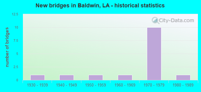
- New bridges - historical statistics
- 11930-1939
- 11940-1949
- 11950-1959
- 11960-1969
- 101970-1979
- 11980-1989


- Bridge Condition - Deck
- 21.4%Good
- 71.4%Satisfactory
- 7.1%Fair

- Bridge Condition - Superstructure
- 28.6%Good
- 50.0%Satisfactory
- 14.3%Fair
- 7.1%Poor

- Bridge Condition - Substructure
- 42.9%Good
- 42.9%Satisfactory
- 7.1%Fair
- 7.1%Poor

- Bridge Condition - Channel
- 23.1%Very good
- 76.9%Good
Find on map >> Show street view
Structure Number: 35100040607451, Location: 0.9 MI NORTH OF LA 83 (Lat: 29.849389, Lng: -91.557000), Route carried "on" structure: State highway 182, Year Built: 1931, Status: Open, Structure Length: 0.88m (2.89ft), Average Daily Traffic: 6,600 (year 2016), Truck Traffic: 13%, Average Future Daily Traffic: 11,220 (year 2036), Design Load: H 15, Features Intersected: BAYOU CHOUPIQUE
Minimum Vertical Clearance: 30+ m (98+ ft), Kilometerpoint: 11.922, Lanes on structure: 2, Base Highway Network: Yes (Inventory Route: 4-06-1, Subroute: 10), Owner: State Highway Agency, Approaching Roadway Width: 10.7m (35.1ft), Material/Design: Concrete, Design/Construction: Culvert, Number Of Spans In Main Unit: 5, Length of Maximum Span: 1.5m (4.9ft), Curb-To-Curb Width: 10.7m (35.1ft), Out-to-Out Width: 13.6m (44.6ft)
Condition: Channel: Good, Culverts: Satisfactory, Operating Rating: 42.1 metric tons, Method Used To Determine Operating Rating: Load and Resistance Factor Rating (LRFR) rating reported by rating factor(RF) method using HL-93 loadings, Inventory Rating: 32.4 metric tons, Method Used To Determine Inventory Rating: Load and Resistance Factor Rating (LRFR) rating reported by rating factor(RF) method using HL-93 loadings, Structural Evaluation: Equal to present minimum criteria, Deck Geometry: Meets minimum limits, Waterway Adequacy: Better than present minimum criteria, Approach Roadway Alignment: Equal to present desirable criteria, Designated Inspection Frequency: Every 24 months, Inspection Date: May 2021, Deck Structure Type: Concrete Cast-file-Place
Find on map >> Show street view
Structure Number: 35100040609371, Location: 2,4 MI NORTH OF LA 3211 (Lat: 29.827000, Lng: -91.541200), Route carried "on" structure: State highway 182, Year Built: 1941, Status: Posted for load, Structure Length: 73.82m (242.19ft), Average Daily Traffic: 7,000 (year 2016), Truck Traffic: 9%, Average Future Daily Traffic: 11,900 (year 2036), Design Load: H 15, Features Intersected: CHARENTON
Minimum Vertical Clearance: 4.57m (14.99ft), Kilometerpoint: 14.985, Lanes on structure: 2, Owner: State Highway Agency, Approaching Roadway Width: 13.4m (44.0ft), Navigation Control: Yes ( Vertical Clearance: 15.9m (52.2ft), Horizontal Clearance: 82.9m (272.0ft)), Material/Design: Steel, Design/Construction: Truss - Thru, Number Of Spans In Main Unit: 1, Number Of Approach Spans: 52, Length of Maximum Span: 91.4m (299.9ft), Curb or Sidewalk Widths: Left: 0.0m, Right: 0.8m (2.6ft), Curb-To-Curb Width: 7.4m (24.3ft), Out-to-Out Width: 8.2m (26.9ft)
Condition: Deck: Satisfactory, Superstructure: Poor, Substructure: Satisfactory, Channel: Good, Operating Rating: 20.1 metric tons, Method Used To Determine Operating Rating: Load and Resistance Factor Rating (LRFR) rating reported by rating factor(RF) method using HL-93 loadings, Inventory Rating: 15.6 metric tons, Method Used To Determine Inventory Rating: Load and Resistance Factor Rating (LRFR) rating reported by rating factor(RF) method using HL-93 loadings, Structural Evaluation: High priority of replacement, Deck Geometry: High priority of replacement, Waterway Adequacy: Equal to present desirable criteria, Approach Roadway Alignment: Equal to present minimum criteria, Bridge Posting: Required (Relationship of Operating Rating to Maximum Legal Load: 20.0 - 29.9% below), Length Of Structure Improvement: 73.82m (242.19ft), Designated Inspection Frequency: Every 24 months, Critical Feature Inspection Frequency: Every 24 months, Other Special Inspection Frequency: Every 12 months, Inspection Date: March 2020, Critical Feature Inspection Date: March 2020, Other Special Inspection Date: March 2021, Bridge Improvement Cost: $6,297,000, Roadway Improvement Cost: $629,000, Total Project Cost: $9,445,000 ( Estimate for 2016), Deck Structure Type: Concrete Cast-file-Place
Find on map >> Show street view
Structure Number: 35102390214901, Location: 0.1 MI WEST OF US 90 (Lat: 29.834319, Lng: -91.567839), Route carried "on" structure: State highway 83, Year Built: 1978, Status: Open, Structure Length: 3.66m (12.01ft), Average Daily Traffic: 460 (year 2016), Truck Traffic: 9%, Average Future Daily Traffic: 1,081 (year 2035), Design Load: HS 20, Features Intersected: BAYOU CHOUPIQUE
Minimum Vertical Clearance: 30+ m (98+ ft), Kilometerpoint: 24.341, Lanes on structure: 2, Owner: State Highway Agency, Approaching Roadway Width: 12.5m (41.0ft), Skew: 10 degrees, Material/Design: Concrete, Design/Construction: Slab, Number Of Spans In Main Unit: 6, Length of Maximum Span: 6.1m (20.0ft), Curb-To-Curb Width: 12.2m (40.0ft), Out-to-Out Width: 13.2m (43.3ft)
Condition: Deck: Satisfactory, Superstructure: Satisfactory, Substructure: Satisfactory, Channel: Very good, Operating Rating: 72.6 metric tons, Method Used To Determine Operating Rating: Load Factor (LF), Inventory Rating: 43.5 metric tons, Method Used To Determine Inventory Rating: Load Factor (LF), Structural Evaluation: Equal to present minimum criteria, Deck Geometry: Better than present minimum criteria, Waterway Adequacy: Equal to present desirable criteria, Approach Roadway Alignment: Equal to present desirable criteria, Designated Inspection Frequency: Every 24 months, Underwater Inspection Frequency: Every 60 months, Inspection Date: November 2020, Underwater Inspection Date: July 2018, Deck Structure Type: Concrete Cast-file-Place
Find on map >> Show street view
Structure Number: 35102390214902, Location: 0.1 MI WEST OF US 90 (Lat: 29.834561, Lng: -91.567500), Route carried "on" structure: State highway 83, Year Built: 1978, Status: Open, Structure Length: 3.66m (12.01ft), Average Daily Traffic: 460 (year 2016), Truck Traffic: 9%, Average Future Daily Traffic: 1,081 (year 2035), Design Load: HS 20, Features Intersected: BAYOU CHOUPIQUE
Minimum Vertical Clearance: 30+ m (98+ ft), Kilometerpoint: 2.071, Lanes on structure: 2, Owner: State Highway Agency, Approaching Roadway Width: 12.5m (41.0ft), Skew: 10 degrees, Material/Design: Concrete, Design/Construction: Slab, Number Of Spans In Main Unit: 6, Length of Maximum Span: 6.1m (20.0ft), Curb-To-Curb Width: 12.2m (40.0ft), Out-to-Out Width: 13.2m (43.3ft)
Condition: Deck: Fair, Superstructure: Fair, Substructure: Poor, Channel: Good, Operating Rating: 72.6 metric tons, Method Used To Determine Operating Rating: Load Factor (LF), Inventory Rating: 43.5 metric tons, Method Used To Determine Inventory Rating: Load Factor (LF), Structural Evaluation: Meets minimum limits, Deck Geometry: Better than present minimum criteria, Waterway Adequacy: Equal to present desirable criteria, Approach Roadway Alignment: Equal to present desirable criteria, Designated Inspection Frequency: Every 24 months, Underwater Inspection Frequency: Every 60 months, Other Special Inspection Frequency: Every 12 months, Inspection Date: Febuary 2022, Underwater Inspection Date: July 2018, Other Special Inspection Date: Febuary 2021, Deck Structure Type: Concrete Cast-file-Place
Find on map >> Show street view
Structure Number: 35104240507164, Location: 0.5 Mi NW of LA 83 (Lat: 29.838931, Lng: -91.568489), Route carried "on" structure: ServiceUS 90, Year Built: 1978, Status: Open, Structure Length: 3.05m (10.01ft), Average Daily Traffic: 2,100 (year 2016), Truck Traffic: 9%, Average Future Daily Traffic: 3,349 (year 2035), Design Load: HS 20, Features Intersected: BAYOU CHOUPIQUE
Minimum Vertical Clearance: 30+ m (98+ ft), Kilometerpoint: 0.774, Lanes on structure: 2, Owner: State Highway Agency, Approaching Roadway Width: 10.4m (34.1ft), Skew: 6 degrees, Material/Design: Concrete, Design/Construction: Slab, Number Of Spans In Main Unit: 5, Length of Maximum Span: 6.1m (20.0ft), Curb-To-Curb Width: 8.6m (28.2ft), Out-to-Out Width: 9.5m (31.2ft)
Condition: Deck: Satisfactory, Superstructure: Satisfactory, Substructure: Good, Channel: Good, Operating Rating: 72.6 metric tons, Method Used To Determine Operating Rating: Load Factor (LF), Inventory Rating: 43.5 metric tons, Method Used To Determine Inventory Rating: Load Factor (LF), Structural Evaluation: Equal to present minimum criteria, Deck Geometry: Meets minimum limits, Waterway Adequacy: Equal to present desirable criteria, Approach Roadway Alignment: Equal to present desirable criteria, Designated Inspection Frequency: Every 24 months, Underwater Inspection Frequency: Every 60 months, Inspection Date: September 2020, Underwater Inspection Date: July 2018, Deck Structure Type: Concrete Cast-file-Place
Find on map >> Show street view
Structure Number: 35104240507176, Location: 0.4 Mi NW of LA 83 (Lat: 29.838611, Lng: -91.568361), Route carried "on" structure: Ramp US 90, Year Built: 1978, Status: Open, Structure Length: 3.66m (12.01ft), Average Daily Traffic: 2,100 (year 2016), Truck Traffic: 14%, Average Future Daily Traffic: 3,349 (year 2035), Design Load: HS 20, Features Intersected: BAYOU CHOUPIQUE
Minimum Vertical Clearance: 30+ m (98+ ft), Kilometerpoint: 0.649, Lanes on structure: 1, Owner: State Highway Agency, Approaching Roadway Width: 7.9m (25.9ft), Skew: 6 degrees, Material/Design: Concrete, Design/Construction: Slab, Number Of Spans In Main Unit: 6, Length of Maximum Span: 6.1m (20.0ft), Curb-To-Curb Width: 7.6m (24.9ft), Out-to-Out Width: 8.6m (28.2ft)
Condition: Deck: Satisfactory, Superstructure: Satisfactory, Substructure: Satisfactory, Channel: Good, Operating Rating: 72.6 metric tons, Method Used To Determine Operating Rating: Load Factor (LF), Inventory Rating: 43.5 metric tons, Method Used To Determine Inventory Rating: Load Factor (LF), Structural Evaluation: Equal to present minimum criteria, Deck Geometry: Better than present minimum criteria, Waterway Adequacy: Equal to present desirable criteria, Approach Roadway Alignment: Equal to present desirable criteria, Designated Inspection Frequency: Every 24 months, Underwater Inspection Frequency: Every 60 months, Inspection Date: November 2020, Underwater Inspection Date: July 2018, Deck Structure Type: Concrete Cast-file-Place
Find on map >> Show street view
Structure Number: 35104240507272, Location: 0.2 Mi. NW of LA 83 (Lat: 29.836531, Lng: -91.567131), Route carried "on" structure: US 90, Year Built: 1978, Status: Open, Structure Length: 14.02m (46.00ft), Average Daily Traffic: 10,500 (year 2016), Truck Traffic: 14%, Average Future Daily Traffic: 20,604 (year 2035), Design Load: HS 20, Features Intersected: CHOUPIQUE BAYOU
Minimum Vertical Clearance: 30+ m (98+ ft), Kilometerpoint: 53.047, Lanes on structure: 2, Base Highway Network: Yes (Inventory Route: 424-05-2, Subroute: 10), Owner: State Highway Agency, Approaching Roadway Width: 11.3m (37.1ft), Skew: 10 degrees, Material/Design: Prestressed concrete, Design/Construction: Stringer/Multi-beam, Number Of Spans In Main Unit: 2, Number Of Approach Spans: 7, Length of Maximum Span: 16.8m (55.1ft), Curb-To-Curb Width: 12.2m (40.0ft), Out-to-Out Width: 13.3m (43.6ft)
Condition: Deck: Good, Superstructure: Good, Substructure: Fair, Channel: Very good, Operating Rating: 71.7 metric tons, Method Used To Determine Operating Rating: Load Factor (LF), Inventory Rating: 32.7 metric tons, Method Used To Determine Inventory Rating: Load Factor (LF), Structural Evaluation: Somewhat better than minimum adequacy, Deck Geometry: Better than present minimum criteria, Waterway Adequacy: Equal to present desirable criteria, Approach Roadway Alignment: Equal to present desirable criteria, Designated Inspection Frequency: Every 24 months, Underwater Inspection Frequency: Every 60 months, Inspection Date: November 2021, Underwater Inspection Date: July 2018, Deck Structure Type: Concrete Cast-file-Place
Find on map >> Show street view
Structure Number: 35104240507311, Location: 0.2 Mi NW of LA 83 (Lat: 29.836850, Lng: -91.567919), Route carried "on" structure: US 90, Year Built: 1978, Status: Open, Structure Length: 10.76m (35.30ft), Average Daily Traffic: 10,500 (year 2016), Truck Traffic: 14%, Average Future Daily Traffic: 20,604 (year 2035), Design Load: HS 20, Features Intersected: CHOUPIQUE BAYOU
Minimum Vertical Clearance: 30+ m (98+ ft), Kilometerpoint: 11.774, Lanes on structure: 2, Base Highway Network: Yes (Inventory Route: 424-05-1, Subroute: 10), Owner: State Highway Agency, Approaching Roadway Width: 11.6m (38.1ft), Skew: 10 degrees, Material/Design: Prestressed concrete continuous, Design/Construction: Stringer/Multi-beam, Number Of Spans In Main Unit: 5, Length of Maximum Span: 15.2m (49.9ft), Curb-To-Curb Width: 12.2m (40.0ft), Out-to-Out Width: 13.2m (43.3ft)
Condition: Deck: Satisfactory, Superstructure: Satisfactory, Substructure: Satisfactory, Channel: Good, Operating Rating: 65.3 metric tons, Method Used To Determine Operating Rating: Load Factor (LF), Inventory Rating: 33.6 metric tons, Method Used To Determine Inventory Rating: Load Factor (LF), Structural Evaluation: Equal to present minimum criteria, Deck Geometry: Better than present minimum criteria, Waterway Adequacy: Equal to present desirable criteria, Approach Roadway Alignment: Equal to present desirable criteria, Designated Inspection Frequency: Every 24 months, Underwater Inspection Frequency: Every 60 months, Inspection Date: November 2021, Underwater Inspection Date: July 2018, Deck Structure Type: Concrete Cast-file-Place
Find on map >> Show street view
Structure Number: 35104240507375, Location: 0.6 Mi N of LA 83 (Lat: 29.836281, Lng: -91.567831), Route carried "on" structure: Ramp US 90, Year Built: 1978, Status: Open, Structure Length: 6.00m (19.69ft), Average Daily Traffic: 2,100 (year 2016), Truck Traffic: 14%, Average Future Daily Traffic: 3,434 (year 2035), Design Load: HS 20, Features Intersected: CHOUPIQUE BAYOU
Minimum Vertical Clearance: 30+ m (98+ ft), Kilometerpoint: 0.293, Lanes on structure: 1, Owner: State Highway Agency, Approaching Roadway Width: 7.9m (25.9ft), Skew: 30 degrees, Material/Design: Concrete continuous, Design/Construction: Slab, Number Of Spans In Main Unit: 10, Length of Maximum Span: 6.1m (20.0ft), Curb-To-Curb Width: 7.7m (25.3ft), Out-to-Out Width: 8.8m (28.9ft)
Condition: Deck: Satisfactory, Superstructure: Good, Substructure: Satisfactory, Channel: Good, Operating Rating: 54.4 metric tons, Method Used To Determine Operating Rating: Load Factor (LF), Inventory Rating: 32.7 metric tons, Method Used To Determine Inventory Rating: Load Factor (LF), Structural Evaluation: Equal to present minimum criteria, Deck Geometry: Better than present minimum criteria, Waterway Adequacy: Equal to present desirable criteria, Approach Roadway Alignment: Equal to present desirable criteria, Designated Inspection Frequency: Every 24 months, Underwater Inspection Frequency: Every 60 months, Inspection Date: November 2021, Underwater Inspection Date: July 2018, Deck Structure Type: Concrete Cast-file-Place
Find on map >> Show street view
Structure Number: 35104240507411, Location: US 90 Over LA 3215 (Lat: 29.835789, Lng: -91.566689), Route carried "on" structure: US 90, Year Built: 1978, Status: Open, Structure Length: 44.78m (146.92ft), Average Daily Traffic: 10,500 (year 2016), Truck Traffic: 14%, Average Future Daily Traffic: 20,604 (year 2035), Design Load: HS 20, Features Intersected: LA 83 & S.P. RR
Minimum Vertical Clearance: 30+ m (98+ ft), Kilometerpoint: 11.941, Lanes on structure: 2, Lanes under structure: 4, Base Highway Network: Yes (Inventory Route: 424-05-1, Subroute: 10), Owner: State Highway Agency, Approaching Roadway Width: 12.5m (41.0ft), Skew: 10 degrees, Material/Design: Prestressed concrete, Design/Construction: Stringer/Multi-beam, Number Of Spans In Main Unit: 22, Length of Maximum Span: 29.0m (95.1ft), Curb-To-Curb Width: 12.2m (40.0ft), Out-to-Out Width: 16.9m (55.4ft)
Condition: Deck: Good, Superstructure: Good, Substructure: Good, Operating Rating: 64.4 metric tons, Method Used To Determine Operating Rating: Load Factor (LF), Inventory Rating: 37.2 metric tons, Method Used To Determine Inventory Rating: Load Factor (LF), Structural Evaluation: Better than present minimum criteria, Deck Geometry: Better than present minimum criteria, Underclear: Superior to present desirable criteria, Approach Roadway Alignment: Equal to present desirable criteria, Designated Inspection Frequency: Every 24 months, Inspection Date: March 2020, Deck Structure Type: Concrete Cast-file-Place
Find on map >> Show street view
Structure Number: 35104240507412, Location: US 90 Over LA 3215 (Lat: 29.833011, Lng: -91.563011), Route carried "on" structure: US 90, Year Built: 1978, Status: Open, Structure Length: 47.06m (154.40ft), Average Daily Traffic: 10,500 (year 2016), Truck Traffic: 14%, Average Future Daily Traffic: 20,604 (year 2035), Design Load: HS 20, Features Intersected: LA 83 & S.P. RR
Minimum Vertical Clearance: 30+ m (98+ ft), Kilometerpoint: 52.489, Lanes on structure: 2, Lanes under structure: 4, Base Highway Network: Yes (Inventory Route: 424-05-2, Subroute: 10), Owner: State Highway Agency, Approaching Roadway Width: 12.5m (41.0ft), Skew: 10 degrees, Material/Design: Prestressed concrete, Design/Construction: Stringer/Multi-beam, Number Of Spans In Main Unit: 22, Length of Maximum Span: 29.0m (95.1ft), Curb-To-Curb Width: 12.2m (40.0ft), Out-to-Out Width: 16.9m (55.4ft)
Condition: Deck: Good, Superstructure: Good, Substructure: Good, Operating Rating: 57.1 metric tons, Method Used To Determine Operating Rating: Load Factor (LF), Inventory Rating: 32.7 metric tons, Method Used To Determine Inventory Rating: Load Factor (LF), Structural Evaluation: Better than present minimum criteria, Deck Geometry: Better than present minimum criteria, Underclear: Superior to present desirable criteria, Approach Roadway Alignment: Equal to present desirable criteria, Designated Inspection Frequency: Every 24 months, Inspection Date: March 2020, Deck Structure Type: Concrete Cast-file-Place
Find on map >> Show street view
Structure Number: 35104240508801, Location: 1.36 Mi E of LA 83 (Lat: 29.820531, Lng: -91.550369), Route carried "on" structure: US 90, Year Built: 1978, Status: Open, Structure Length: 89.12m (292.39ft), Average Daily Traffic: 21,000 (year 2016), Truck Traffic: 14%, Average Future Daily Traffic: 20,604 (year 2035), Design Load: HS 20, Features Intersected: CHARENTON CANAL
Minimum Vertical Clearance: 30+ m (98+ ft), Kilometerpoint: 14.285, Lanes on structure: 2, Base Highway Network: Yes (Inventory Route: 424-05-1, Subroute: 10), Owner: State Highway Agency, Approaching Roadway Width: 12.2m (40.0ft), Skew: 10 degrees, Navigation Control: Yes ( Vertical Clearance: 16.8m (55.1ft), Horizontal Clearance: 31.7m (104.0ft)), Material/Design: Steel, Design/Construction: Stringer/Multi-beam, Number Of Spans In Main Unit: 1, Number Of Approach Spans: 36, Length of Maximum Span: 45.7m (149.9ft), Curb-To-Curb Width: 12.2m (40.0ft), Out-to-Out Width: 13.2m (43.3ft)
Condition: Deck: Satisfactory, Superstructure: Satisfactory, Substructure: Good, Channel: Good, Operating Rating: 68.0 metric tons, Method Used To Determine Operating Rating: Load Factor (LF), Inventory Rating: 40.8 metric tons, Method Used To Determine Inventory Rating: Load Factor (LF), Structural Evaluation: Equal to present minimum criteria, Deck Geometry: Somewhat better than minimum adequacy, Waterway Adequacy: Equal to present desirable criteria, Approach Roadway Alignment: Equal to present desirable criteria, Designated Inspection Frequency: Every 24 months, Underwater Inspection Frequency: Every 60 months, Inspection Date: March 2021, Underwater Inspection Date: Febuary 2019, Deck Structure Type: Concrete Cast-file-Place
Find on map >> Show street view
Structure Number: 35129496913161, Location: 0.2 Mi. N of La 182 (Lat: 29.826381, Lng: -91.527600), Route carried "on" structure: County highway , Year Built: 1959, Status: Posted for load, Structure Length: 11.77m (38.62ft), Average Daily Traffic: 1,050 (year 1971), Average Future Daily Traffic: 1,785 (year 2035), Design Load: H 15, Features Intersected: TECHE BAYOU, Facility Carried by Structure: Katy Bridge App Rd
Minimum Vertical Clearance: 30+ m (98+ ft), Kilometerpoint: 0.000, Lanes on structure: 2, Owner: County Highway Agency, Approaching Roadway Width: 8.5m (27.9ft), Navigation Control: Yes ( Vertical Clearance: 2.7m (8.9ft), Horizontal Clearance: 18.6m (61.0ft)), Material/Design: Steel, Design/Construction: Movable - Swing, Number Of Spans In Main Unit: 11, Length of Maximum Span: 54.9m (180.1ft), Curb-To-Curb Width: 7.3m (24.0ft), Out-to-Out Width: 9.0m (29.5ft)
Condition: Deck: Satisfactory, Superstructure: Fair, Substructure: Satisfactory, Channel: Very good, Operating Rating: 17.5 metric tons, Method Used To Determine Operating Rating: Load and Resistance Factor Rating (LRFR) rating reported by rating factor(RF) method using HL-93 loadings, Inventory Rating: 13.6 metric tons, Method Used To Determine Inventory Rating: Load and Resistance Factor Rating (LRFR) rating reported by rating factor(RF) method using HL-93 loadings, Structural Evaluation: Meets minimum limits, Deck Geometry: Meets minimum limits, Waterway Adequacy: Equal to present desirable criteria, Approach Roadway Alignment: Equal to present minimum criteria, Bridge Posting: Required (Relationship of Operating Rating to Maximum Legal Load: 20.0 - 29.9% below), Designated Inspection Frequency: Every 24 months, Critical Feature Inspection Frequency: Every 24 months, Underwater Inspection Frequency: Every 60 months, Inspection Date: April 2021, Critical Feature Inspection Date: April 2021, Underwater Inspection Date: June 2018, Deck Structure Type: Open Grating
Find on map >> Show street view
Structure Number: 35129498913401, Location: 0.2 Mi. W of US 90 (Lat: 29.830581, Lng: -91.567700), Route carried "on" structure: County highway , Year Built: 1984, Status: Open, Structure Length: 2.35m (7.71ft), Average Daily Traffic: 200 (year 1982), Average Future Daily Traffic: 340 (year 2035), Design Load: HS 20, Features Intersected: CHOUPIQUE BAYOU, Facility Carried by Structure: Labau St.
Minimum Vertical Clearance: 30+ m (98+ ft), Kilometerpoint: 0.000, Lanes on structure: 2, Owner: County Highway Agency, Approaching Roadway Width: 9.1m (29.9ft), Material/Design: Concrete, Design/Construction: Slab, Number Of Spans In Main Unit: 4, Length of Maximum Span: 5.8m (19.0ft), Curb-To-Curb Width: 7.3m (24.0ft), Out-to-Out Width: 8.2m (26.9ft)
Condition: Deck: Satisfactory, Superstructure: Satisfactory, Substructure: Good, Channel: Good, Operating Rating: 47.6 metric tons, Method Used To Determine Operating Rating: Load and Resistance Factor Rating (LRFR) rating reported by rating factor(RF) method using HL-93 loadings, Inventory Rating: 36.6 metric tons, Method Used To Determine Inventory Rating: Load and Resistance Factor Rating (LRFR) rating reported by rating factor(RF) method using HL-93 loadings, Structural Evaluation: Equal to present minimum criteria, Deck Geometry: Somewhat better than minimum adequacy, Waterway Adequacy: Equal to present desirable criteria, Approach Roadway Alignment: Equal to present minimum criteria, Designated Inspection Frequency: Every 24 months, Underwater Inspection Frequency: Every 60 months, Inspection Date: April 2021, Underwater Inspection Date: December 2018, Deck Structure Type: Concrete Cast-file-Place
Find on map >> Show street view
Structure Number: 35129499913401, Location: 0.2 Mi SE of La 83 (Lat: 29.832900, Lng: -91.567531), Route carried "on" structure: County highway , Year Built: 1965, Status: Posted for load, Structure Length: 3.66m (12.01ft), Average Daily Traffic: 210 (year 1978), Average Future Daily Traffic: 357 (year 2035), Design Load: HS 20, Features Intersected: CHOUPIQUE BAYOU, Facility Carried by Structure: MLK Jr. St.
Minimum Vertical Clearance: 30+ m (98+ ft), Kilometerpoint: 0.000, Lanes on structure: 2, Owner: County Highway Agency, Approaching Roadway Width: 8.2m (26.9ft), Material/Design: Concrete, Design/Construction: Slab, Number Of Spans In Main Unit: 6, Length of Maximum Span: 6.1m (20.0ft), Curb-To-Curb Width: 7.3m (24.0ft), Out-to-Out Width: 8.8m (28.9ft)
Condition: Deck: Satisfactory, Superstructure: Satisfactory, Substructure: Good, Channel: Good, Operating Rating: 35.3 metric tons, Method Used To Determine Operating Rating: Load and Resistance Factor Rating (LRFR) rating reported by rating factor(RF) method using HL-93 loadings, Inventory Rating: 27.2 metric tons, Method Used To Determine Inventory Rating: Load and Resistance Factor Rating (LRFR) rating reported by rating factor(RF) method using HL-93 loadings, Structural Evaluation: Equal to present minimum criteria, Deck Geometry: Somewhat better than minimum adequacy, Waterway Adequacy: Better than present minimum criteria, Approach Roadway Alignment: Equal to present desirable criteria, Designated Inspection Frequency: Every 24 months, Underwater Inspection Frequency: Every 60 months, Inspection Date: April 2021, Underwater Inspection Date: July 2018, Deck Structure Type: Concrete Cast-file-Place
Find on map >> Show street view
Structure Number: 35104240507411, Location: 1.18 miles S of LA 182 (Lat: 29.834900, Lng: -91.565511), Route carried "under" structure: State highway 83, Structure Length: 0. m, Average Daily Traffic: 460 (year 2016), Features Intersected: LA 83 SB under US 90 EB
Minimum Vertical Clearance: 6.04m (19.82ft), Kilometerpoint: 1.878, Lanes on structure: 2, Lanes under structure: 2, Length of Maximum Span: 0.0m
Find on map >> Show street view
Structure Number: 35104240507411, Location: .27 miles N of 90 S. Rd. (Lat: 29.834711, Lng: -91.565569), Route carried "under" structure: State highway 83, Structure Length: 0. m, Average Daily Traffic: 460 (year 2016), Features Intersected: LA 83 NB under US 90 EB
Minimum Vertical Clearance: 6.34m (20.80ft), Kilometerpoint: 24.562, Lanes on structure: 2, Lanes under structure: 2, Length of Maximum Span: 0.0m
Find on map >> Show street view
Structure Number: 35104240507412, Location: .3 miles N of 90 S. Rd. (Lat: 29.834781, Lng: -91.565169), Route carried "under" structure: State highway 83, Structure Length: 0. m, Average Daily Traffic: 460 (year 2016), Features Intersected: LA 83 NB under US 90 WB
Minimum Vertical Clearance: 6.71m (22.01ft), Kilometerpoint: 24.600, Lanes on structure: 2, Lanes under structure: 2, Length of Maximum Span: 0.0m
Find on map >> Show street view
Structure Number: 35104240507412, Location: 1.15 miles S of LA 182 (Lat: 29.834961, Lng: -91.565161), Route carried "under" structure: State highway 83, Structure Length: 0. m, Average Daily Traffic: 460 (year 2016), Features Intersected: LA 83 SB under US 90 WB
Minimum Vertical Clearance: 6.49m (21.29ft), Kilometerpoint: 1.844, Lanes on structure: 2, Lanes under structure: 2, Length of Maximum Span: 0.0m
Find on map >> Show street view
Structure Number: 35104240508801, Location: 1.6 MI SE OF LA 83 (Lat: 29.820050, Lng: -91.549650), Route carried "under" structure: ServiceUS 90, Structure Length: 0. m, Average Daily Traffic: 2,167 (year 2014), Features Intersected: US 90 FRONTAGE RD UNDER
Minimum Vertical Clearance: 7.13m (23.39ft), Kilometerpoint: 2.063, Lanes on structure: 2, Lanes under structure: 2, Length of Maximum Span: 0.0m
Find on map >> Show street view
Structure Number: 35104240508802, Location: 1.6 MI SE OF LA 83 (Lat: 29.820350, Lng: -91.549389), Route carried "under" structure: ServiceUS 90, Structure Length: 0. m, Average Daily Traffic: 2,167 (year 2014), Features Intersected: US 90 FRONTAGE RD UNDER
Minimum Vertical Clearance: 7.16m (23.49ft), Kilometerpoint: 0.021, Lanes on structure: 2, Lanes under structure: 2, Length of Maximum Span: 0.0m