Bridge Statistics for Ballston, New York (NY)
Condition, Traffic, Stress, Structural Evaluation, Project Costs
- National Bridge Inventory (NBI) Statistics
- 13Number of bridges
- 43ft / 12.7mTotal length
- $9,276,000Total costs
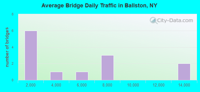
- 55,573Total average daily traffic
- 3,313Total average daily truck traffic
- National Bridge Inventory (NBI) Registered Bridges for Ballston
- No street view available for this location
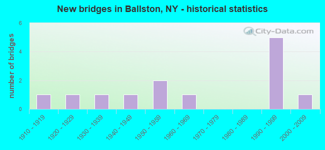
- New bridges - historical statistics
- 11910-1919
- 11920-1929
- 11930-1939
- 11940-1949
- 21950-1959
- 11960-1969
- 51990-1999
- 12000-2009
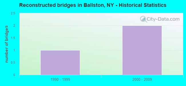
- Reconstructed bridges - Historical Statistics
- 11990-1999
- 22000-2009
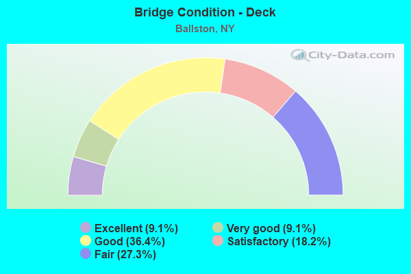
- Bridge Condition - Deck
- 9.1%Excellent
- 9.1%Very good
- 36.4%Good
- 18.2%Satisfactory
- 27.3%Fair
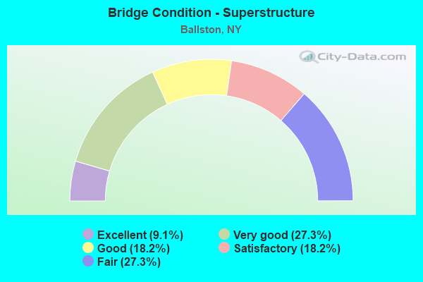
- Bridge Condition - Superstructure
- 9.1%Excellent
- 27.3%Very good
- 18.2%Good
- 18.2%Satisfactory
- 27.3%Fair
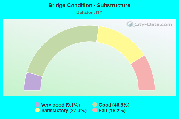
- Bridge Condition - Substructure
- 9.1%Very good
- 45.5%Good
- 27.3%Satisfactory
- 18.2%Fair
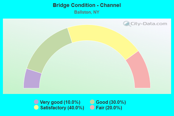
- Bridge Condition - Channel
- 10.0%Very good
- 30.0%Good
- 40.0%Satisfactory
- 20.0%Fair
Find on map >> Show street view
Structure Number: 102633, Location: 1.2MI SW JCT 50 & 67 (Lat: 42.972269, Lng: -73.862631), Route carried "on" structure: State highway 50, Year Built: 1995, Status: Open, Structure Length: 2.68m (8.79ft), Average Daily Traffic: 7,868 (year 2018), Truck Traffic: 6%, Average Future Daily Traffic: 7,904 (year 2040), Design Load: HS 25 or greater, Features Intersected: MOURNING KILL
Minimum Vertical Clearance: 30+ m (98+ ft), Kilometerpoint: 8.496, Lanes on structure: 2, Base Highway Network: Yes, Owner: State Highway Agency, Approaching Roadway Width: 12.2m (40.0ft), Material/Design: Steel, Design/Construction: Stringer/Multi-beam, Number Of Spans In Main Unit: 1, Length of Maximum Span: 25.6m (84.0ft), Curb-To-Curb Width: 12.2m (40.0ft), Out-to-Out Width: 12.8m (42.0ft)
Condition: Deck: Good, Superstructure: Good, Substructure: Good, Channel: Very good, Operating Rating: 72.6 metric tons, Method Used To Determine Operating Rating: Load Factor (LF), Inventory Rating: 43.5 metric tons, Method Used To Determine Inventory Rating: Load Factor (LF), Structural Evaluation: Better than present minimum criteria, Deck Geometry: Somewhat better than minimum adequacy, Waterway Adequacy: Superior to present desirable criteria, Approach Roadway Alignment: Equal to present desirable criteria, Length Of Structure Improvement: 2.68m (8.79ft), Designated Inspection Frequency: Every 24 months, Inspection Date: April 2021, Bridge Improvement Cost: $924,000, Roadway Improvement Cost: $541,000, Total Project Cost: $1,464,000 ( Estimate for 2021), Deck Structure Type: Concrete Cast-file-Place, Wearing Surface/Protective System: Wearing Surface: Integral Concrete, Deck Protection: Epoxy Coated Reinforcing
Find on map >> Show street view
Structure Number: 102915, Location: RTE 67 & MORNING KILL (Lat: 42.985397, Lng: -73.931517), Route carried "on" structure: State highway 67, Year Built: 1959, Status: Open, Structure Length: 0.70m (2.30ft), Average Daily Traffic: 6,794 (year 2018), Truck Traffic: 8%, Average Future Daily Traffic: 7,611 (year 2040), Features Intersected: MOURNING KILL
Minimum Vertical Clearance: 30+ m (98+ ft), Kilometerpoint: 13.902, Lanes on structure: 2, Base Highway Network: Yes, Owner: State Highway Agency, Approaching Roadway Width: 10.4m (34.1ft), Skew: 1 degrees, Material/Design: Concrete, Design/Construction: Frame, Number Of Spans In Main Unit: 1, Length of Maximum Span: 6.7m (22.0ft), Curb-To-Curb Width: 11.9m (39.0ft), Out-to-Out Width: 16.6m (54.5ft)
Condition: Deck: Satisfactory, Superstructure: Satisfactory, Substructure: Good, Channel: Satisfactory, Operating Rating: 68.0 metric tons, Method Used To Determine Operating Rating: Load Factor (LF), Inventory Rating: 40.8 metric tons, Method Used To Determine Inventory Rating: Load Factor (LF), Structural Evaluation: Equal to present minimum criteria, Deck Geometry: Somewhat better than minimum adequacy, Waterway Adequacy: Superior to present desirable criteria, Approach Roadway Alignment: Equal to present desirable criteria, Length Of Structure Improvement: 0.70m (2.30ft), Designated Inspection Frequency: Every 24 months, Inspection Date: May 2020, Bridge Improvement Cost: $499,000, Roadway Improvement Cost: $292,000, Total Project Cost: $791,000 ( Estimate for 2021), Wearing Surface/Protective System: Wearing Surface: Bituminous
Find on map >> Show street view
Structure Number: 102918, Location: 1.3 MI SE JCT RTS 50 & 67 (Lat: 42.974139, Lng: -73.841306), Route carried "on" structure: State highway 67, Year Built: 2008, Status: Open, Structure Length: 0.94m (3.08ft), Average Daily Traffic: 12,951 (year 2018), Truck Traffic: 7%, Average Future Daily Traffic: 13,011 (year 2040), Design Load: HS 25 or greater, Features Intersected: ZIM SMITH TRAIL
Minimum Vertical Clearance: 30+ m (98+ ft), Kilometerpoint: 24.746, Lanes on structure: 2, Base Highway Network: Yes, Owner: State Highway Agency, Approaching Roadway Width: 11.9m (39.0ft), Skew: 3 degrees, Material/Design: Concrete, Design/Construction: Frame, Number Of Spans In Main Unit: 1, Length of Maximum Span: 9.1m (29.9ft), Curb-To-Curb Width: 12.0m (39.4ft), Out-to-Out Width: 13.3m (43.6ft)
Condition: Deck: Very good, Superstructure: Very good, Substructure: Good, Operating Rating: 87.1 metric tons, Method Used To Determine Operating Rating: Load Factor (LF), Inventory Rating: 51.7 metric tons, Method Used To Determine Inventory Rating: Load Factor (LF), Structural Evaluation: Better than present minimum criteria, Deck Geometry: Somewhat better than minimum adequacy, Approach Roadway Alignment: Equal to present desirable criteria, Length Of Structure Improvement: 0.94m (3.08ft), Designated Inspection Frequency: Every 24 months, Inspection Date: April 2020, Bridge Improvement Cost: $503,000, Roadway Improvement Cost: $294,000, Total Project Cost: $797,000 ( Estimate for 2021), Wearing Surface/Protective System: Wearing Surface: Bituminous
Find on map >> Show street view
Structure Number: 105365, Location: 0.9 MI SE JCT RTS 50 & 67 (Lat: 42.975897, Lng: -73.847725), Route carried "on" structure: State highway 67, Year Built: 1993, Status: Open, Structure Length: 1.86m (6.10ft), Average Daily Traffic: 12,951 (year 2018), Truck Traffic: 7%, Average Future Daily Traffic: 13,011 (year 2040), Design Load: HS 20, Features Intersected: RR BRIDGE 7029170, MOURN
Minimum Vertical Clearance: 4.57m (14.99ft), Kilometerpoint: 24.199, Lanes on structure: 2, Base Highway Network: Yes, Owner: State Highway Agency, Approaching Roadway Width: 10.7m (35.1ft), Skew: 3 degrees, Material/Design: Prestressed concrete, Design/Construction: Box Beam or Girders - Multiple, Number Of Spans In Main Unit: 1, Length of Maximum Span: 17.0m (55.8ft), Curb-To-Curb Width: 10.7m (35.1ft), Out-to-Out Width: 11.3m (37.1ft)
Condition: Deck: Fair, Superstructure: Fair, Substructure: Good, Channel: Satisfactory, Operating Rating: 72.6 metric tons, Method Used To Determine Operating Rating: Load Factor (LF), Inventory Rating: 34.5 metric tons, Method Used To Determine Inventory Rating: Load Factor (LF), Structural Evaluation: Somewhat better than minimum adequacy, Deck Geometry: Meets minimum limits, Waterway Adequacy: Superior to present desirable criteria, Approach Roadway Alignment: Equal to present desirable criteria, Length Of Structure Improvement: 1.85m (6.07ft), Designated Inspection Frequency: Every 24 months, Inspection Date: April 2020, Bridge Improvement Cost: $970,000, Roadway Improvement Cost: $568,000, Total Project Cost: $1,538,000 ( Estimate for 2021), Wearing Surface/Protective System: Wearing Surface: Monolithic Concrete
Find on map >> Show street view
Structure Number: 220255, Location: 3MI W BALSTON SPA (Lat: 42.985417, Lng: -73.932956), Route carried "on" structure: Other road , Year Built: 1925, Year Reconstructed: 1995, Status: Posted for load-capacity, Structure Length: 0.73m (2.40ft), Average Daily Traffic: 202 (year 2020), Truck Traffic: 6%, Average Future Daily Traffic: 283 (year 2040), Design Load: HS 25 or greater, Features Intersected: MOURNING KILL, Facility Carried by Structure: FINLEY ROAD
Minimum Vertical Clearance: 30+ m (98+ ft), Kilometerpoint: 0.064, Lanes on structure: 2, Owner: Town or Township Highway Agency, Approaching Roadway Width: 6.1m (20.0ft), Material/Design: Steel, Design/Construction: Stringer/Multi-beam, Number Of Spans In Main Unit: 1, Length of Maximum Span: 7.0m (23.0ft), Curb-To-Curb Width: 6.1m (20.0ft), Out-to-Out Width: 6.4m (21.0ft)
Condition: Deck: Fair, Superstructure: Fair, Substructure: Fair, Channel: Fair, Operating Rating: 67.1 metric tons, Method Used To Determine Operating Rating: Allowable Stress (AS), Inventory Rating: 46.3 metric tons, Method Used To Determine Inventory Rating: Allowable Stress (AS), Structural Evaluation: Somewhat better than minimum adequacy, Deck Geometry: Meets minimum limits, Waterway Adequacy: Superior to present desirable criteria, Approach Roadway Alignment: Equal to present minimum criteria, Length Of Structure Improvement: 0.73m (2.40ft), Designated Inspection Frequency: Every 24 months, Inspection Date: April 2021, Bridge Improvement Cost: $180,000, Roadway Improvement Cost: $105,000, Total Project Cost: $285,000 ( Estimate for 2021), Deck Structure Type: Corrugated Steel, Wearing Surface/Protective System: Wearing Surface: Bituminous
Find on map >> Show street view
Structure Number: 330438, Location: 1.5 MI SW JCT NYS 50 & 67 (Lat: 42.970053, Lng: -73.879328), Route carried "on" structure: County highway , Year Built: 1998, Status: Open, Structure Length: 1.28m (4.20ft), Average Daily Traffic: 2,800 (year 2020), Truck Traffic: 8%, Average Future Daily Traffic: 2,920 (year 2040), Design Load: HS 25 or greater, Features Intersected: MOURNING KILL, Facility Carried by Structure: CR 59, MIDDLE LINE
Minimum Vertical Clearance: 30+ m (98+ ft), Kilometerpoint: 3.540, Lanes on structure: 2, Owner: County Highway Agency, Approaching Roadway Width: 10.7m (35.1ft), Skew: 2 degrees, Material/Design: Prestressed concrete, Design/Construction: Box Beam or Girders - Multiple, Number Of Spans In Main Unit: 1, Length of Maximum Span: 12.2m (40.0ft), Curb-To-Curb Width: 10.7m (35.1ft), Out-to-Out Width: 11.3m (37.1ft)
Condition: Deck: Satisfactory, Superstructure: Very good, Substructure: Very good, Channel: Good, Operating Rating: 89.8 metric tons, Method Used To Determine Operating Rating: Load Factor (LF), Inventory Rating: 40.8 metric tons, Method Used To Determine Inventory Rating: Load Factor (LF), Structural Evaluation: Equal to present desirable criteria, Deck Geometry: Somewhat better than minimum adequacy, Waterway Adequacy: Superior to present desirable criteria, Approach Roadway Alignment: Equal to present desirable criteria, Length Of Structure Improvement: 1.28m (4.20ft), Designated Inspection Frequency: Every 24 months, Inspection Date: April 2020, Bridge Improvement Cost: $623,000, Roadway Improvement Cost: $365,000, Total Project Cost: $988,000 ( Estimate for 2021), Wearing Surface/Protective System: Wearing Surface: Monolithic Concrete
Find on map >> Show street view
Structure Number: 330439, Location: 4 MI SW BALLSTON SPA (Lat: 42.973797, Lng: -73.920711), Route carried "on" structure: County highway , Year Built: 1991, Status: Open, Structure Length: 0.76m (2.49ft), Average Daily Traffic: 668 (year 2019), Truck Traffic: 8%, Average Future Daily Traffic: 935 (year 2039), Features Intersected: MOURNING KILL, Facility Carried by Structure: HOP CITY ROAD
Minimum Vertical Clearance: 30+ m (98+ ft), Kilometerpoint: 7.241, Lanes on structure: 2, Owner: County Highway Agency, Approaching Roadway Width: 8.0m (26.2ft), Skew: 3 degrees, Material/Design: Concrete, Design/Construction: Frame, Number Of Spans In Main Unit: 1, Length of Maximum Span: 7.0m (23.0ft), Curb-To-Curb Width: 8.0m (26.2ft), Out-to-Out Width: 8.9m (29.2ft)
Condition: Deck: Good, Superstructure: Good, Substructure: Good, Channel: Good, Operating Rating: 60.8 metric tons, Method Used To Determine Operating Rating: Load Factor (LF), Inventory Rating: 36.3 metric tons, Method Used To Determine Inventory Rating: Load Factor (LF), Structural Evaluation: Better than present minimum criteria, Deck Geometry: Somewhat better than minimum adequacy, Waterway Adequacy: Superior to present desirable criteria, Approach Roadway Alignment: Equal to present desirable criteria, Length Of Structure Improvement: 0.76m (2.49ft), Designated Inspection Frequency: Every 24 months, Inspection Date: May 2020, Bridge Improvement Cost: $296,000, Roadway Improvement Cost: $173,000, Total Project Cost: $470,000 ( Estimate for 2021), Wearing Surface/Protective System: Wearing Surface: Bituminous
Find on map >> Show street view
Structure Number: 330467, Location: .5 MI S JCT NY50(Lat: 42.976536, Lng: -73.850689), Route carried "on" structure: Other road , Year Built: 1962, Status: Open, Structure Length: 0.88m (2.89ft), Average Daily Traffic: 35 (year 2017), Truck Traffic: 6%, Average Future Daily Traffic: 49 (year 2037), Design Load: H 20, Features Intersected: MOURNING KILL, Facility Carried by Structure: TIFFAULT RD
Minimum Vertical Clearance: 30+ m (98+ ft), Kilometerpoint: 0.064, Lanes on structure: 2, Owner: County Highway Agency, Approaching Roadway Width: 6.1m (20.0ft), Material/Design: Steel, Design/Construction: Stringer/Multi-beam, Number Of Spans In Main Unit: 1, Length of Maximum Span: 7.9m (25.9ft), Curb-To-Curb Width: 7.3m (24.0ft), Out-to-Out Width: 7.9m (25.9ft)
Condition: Deck: Good, Superstructure: Fair, Substructure: Satisfactory, Channel: Satisfactory, Operating Rating: 83.6 metric tons, Method Used To Determine Operating Rating: Load and Resistance Factor Rating (LRFR) rating reported by rating factor(RF) method using HL-93 loadings, Inventory Rating: 64.5 metric tons, Method Used To Determine Inventory Rating: Load and Resistance Factor Rating (LRFR) rating reported by rating factor(RF) method using HL-93 loadings, Structural Evaluation: Somewhat better than minimum adequacy, Deck Geometry: Equal to present minimum criteria, Waterway Adequacy: Somewhat better than minimum adequacy, Approach Roadway Alignment: Equal to present minimum criteria, Length Of Structure Improvement: 0.88m (2.89ft), Designated Inspection Frequency: Every 24 months, Inspection Date: May 2020, Bridge Improvement Cost: $373,000, Roadway Improvement Cost: $219,000, Total Project Cost: $592,000 ( Estimate for 2021), Deck Structure Type: Concrete Cast-file-Place, Wearing Surface/Protective System: Wearing Surface: Bituminous
Structure Number: 330467, Location: .5 MI S JCT NY50
Minimum Vertical Clearance: 30+ m (98+ ft), Kilometerpoint: 0.064, Lanes on structure: 2, Owner: County Highway Agency, Approaching Roadway Width: 6.1m (20.0ft), Material/Design: Steel, Design/Construction: Stringer/Multi-beam, Number Of Spans In Main Unit: 1, Length of Maximum Span: 7.9m (25.9ft), Curb-To-Curb Width: 7.3m (24.0ft), Out-to-Out Width: 7.9m (25.9ft)
Condition: Deck: Good, Superstructure: Fair, Substructure: Satisfactory, Channel: Satisfactory, Operating Rating: 83.6 metric tons, Method Used To Determine Operating Rating: Load and Resistance Factor Rating (LRFR) rating reported by rating factor(RF) method using HL-93 loadings, Inventory Rating: 64.5 metric tons, Method Used To Determine Inventory Rating: Load and Resistance Factor Rating (LRFR) rating reported by rating factor(RF) method using HL-93 loadings, Structural Evaluation: Somewhat better than minimum adequacy, Deck Geometry: Equal to present minimum criteria, Waterway Adequacy: Somewhat better than minimum adequacy, Approach Roadway Alignment: Equal to present minimum criteria, Length Of Structure Improvement: 0.88m (2.89ft), Designated Inspection Frequency: Every 24 months, Inspection Date: May 2020, Bridge Improvement Cost: $373,000, Roadway Improvement Cost: $219,000, Total Project Cost: $592,000 ( Estimate for 2021), Deck Structure Type: Concrete Cast-file-Place, Wearing Surface/Protective System: Wearing Surface: Bituminous
Find on map >> Show street view
Structure Number: 330469, Location: 1.5 MI SW JCT SH50 & SH67 (Lat: 42.968425, Lng: -73.881325), Route carried "on" structure: Other road , Year Built: 1950, Year Reconstructed: 2000, Status: Open, Structure Length: 0.88m (2.89ft), Average Daily Traffic: 143 (year 2020), Truck Traffic: 6%, Average Future Daily Traffic: 200 (year 2040), Design Load: HS 25 or greater, Features Intersected: MOURNING KILL, Facility Carried by Structure: DEVILS LANE
Minimum Vertical Clearance: 30+ m (98+ ft), Kilometerpoint: 3.138, Lanes on structure: 2, Owner: County Highway Agency, Approaching Roadway Width: 7.9m (25.9ft), Material/Design: Prestressed concrete, Design/Construction: Slab, Number Of Spans In Main Unit: 1, Length of Maximum Span: 8.5m (27.9ft), Curb-To-Curb Width: 9.1m (29.9ft), Out-to-Out Width: 10.1m (33.1ft)
Condition: Deck: Good, Superstructure: Very good, Substructure: Satisfactory, Channel: Good, Operating Rating: 78.9 metric tons, Method Used To Determine Operating Rating: Load Factor (LF), Inventory Rating: 40.8 metric tons, Method Used To Determine Inventory Rating: Load Factor (LF), Structural Evaluation: Equal to present minimum criteria, Deck Geometry: Equal to present minimum criteria, Waterway Adequacy: Superior to present desirable criteria, Approach Roadway Alignment: Equal to present desirable criteria, Length Of Structure Improvement: 0.88m (2.89ft), Designated Inspection Frequency: Every 24 months, Inspection Date: April 2021, Bridge Improvement Cost: $548,000, Roadway Improvement Cost: $321,000, Total Project Cost: $868,000 ( Estimate for 2021), Wearing Surface/Protective System: Wearing Surface: Monolithic Concrete
Find on map >> Show street view
Structure Number: 33047, Location: BALLSTON SPA (Lat: 42.975894, Lng: -73.925067), Route carried "on" structure: Other road , Year Built: 1949, Status: Open, Structure Length: 0.88m (2.89ft), Average Daily Traffic: 124 (year 2017), Truck Traffic: 6%, Average Future Daily Traffic: 174 (year 2037), Design Load: H 20, Features Intersected: MOURNING KILL, Facility Carried by Structure: LASHER RD
Minimum Vertical Clearance: 30+ m (98+ ft), Kilometerpoint: 3.620, Lanes on structure: 2, Owner: County Highway Agency, Approaching Roadway Width: 5.8m (19.0ft), Material/Design: Steel, Design/Construction: Stringer/Multi-beam, Number Of Spans In Main Unit: 1, Length of Maximum Span: 8.2m (26.9ft), Curb-To-Curb Width: 8.1m (26.6ft), Out-to-Out Width: 8.8m (28.9ft)
Condition: Deck: Fair, Superstructure: Satisfactory, Substructure: Fair, Channel: Satisfactory, Operating Rating: 63.5 metric tons, Method Used To Determine Operating Rating: Load Factor (LF), Inventory Rating: 38.1 metric tons, Method Used To Determine Inventory Rating: Load Factor (LF), Structural Evaluation: Somewhat better than minimum adequacy, Deck Geometry: Somewhat better than minimum adequacy, Waterway Adequacy: Meets minimum limits, Approach Roadway Alignment: Equal to present minimum criteria, Length Of Structure Improvement: 0.88m (2.89ft), Designated Inspection Frequency: Every 24 months, Inspection Date: June 2020, Bridge Improvement Cost: $293,000, Roadway Improvement Cost: $172,000, Total Project Cost: $465,000 ( Estimate for 2021), Deck Structure Type: Closed Grating, Wearing Surface/Protective System: Wearing Surface: Bituminous, Membrane: Other
Find on map >> Show street view
Structure Number: 330471, Location: 2.2 MI S BALLSTON SPA (Lat: 42.956803, Lng: -73.848069), Route carried "on" structure: County highway , Year Built: 1990, Year Reconstructed: 2013, Status: Open, Structure Length: 1.07m (3.51ft), Average Daily Traffic: 508 (year 2019), Truck Traffic: 9%, Average Future Daily Traffic: 711 (year 2039), Design Load: HS 25 or greater, Features Intersected: BALLSTON CREEK, Facility Carried by Structure: OUTLET ROAD
Minimum Vertical Clearance: 30+ m (98+ ft), Kilometerpoint: 1.432, Lanes on structure: 2, Owner: County Highway Agency, Approaching Roadway Width: 7.6m (24.9ft), Material/Design: Steel, Design/Construction: Stringer/Multi-beam, Number Of Spans In Main Unit: 1, Length of Maximum Span: 10.0m (32.8ft), Curb-To-Curb Width: 7.7m (25.3ft), Out-to-Out Width: 8.7m (28.5ft)
Condition: Deck: Excellent, Superstructure: Excellent, Substructure: Satisfactory, Channel: Fair, Operating Rating: 40.8 metric tons, Method Used To Determine Operating Rating: Load and Resistance Factor Rating (LRFR) rating reported by rating factor(RF) method using HL-93 loadings, Inventory Rating: 31.4 metric tons, Method Used To Determine Inventory Rating: Load and Resistance Factor Rating (LRFR) rating reported by rating factor(RF) method using HL-93 loadings, Structural Evaluation: Equal to present minimum criteria, Deck Geometry: Meets minimum limits, Waterway Adequacy: Equal to present desirable criteria, Approach Roadway Alignment: Equal to present desirable criteria, Length Of Structure Improvement: 1.06m (3.48ft), Designated Inspection Frequency: Every 24 months, Inspection Date: April 2020, Bridge Improvement Cost: $642,000, Roadway Improvement Cost: $376,000, Total Project Cost: $1,018,000 ( Estimate for 2021), Deck Structure Type: Other, Wearing Surface/Protective System: Wearing Surface: Bituminous
Find on map >> Show street view
Structure Number: 702917, Location: JCT RTE 67 & D&H RR (Lat: 42.975831, Lng: -73.847742), Route carried "under" structure: State highway 67, Year Built: 1916, Structure Length: 0. m, Average Daily Traffic: 6,000 (year 1979), Features Intersected: RTE 67, MOURNING KILL, Facility Carried by Structure: DELAWARE & HUDSON
Minimum Vertical Clearance: 4.52m (14.83ft), Kilometerpoint: 24.248, Lanes under structure: 2, Material/Design: Steel, Design/Construction: Girder and Floorbeam System, Length of Maximum Span: 24.6m (80.7ft)
Find on map >> Show street view
Structure Number: 770909, Location: BALLSTON SPA (Lat: 43.001489, Lng: -73.838533), Route carried "under" structure: Other road , Year Built: 1935, Structure Length: 0. m, Average Daily Traffic: 4,529 (year 2016), Truck Traffic: 3%, Features Intersected: EAST HIGH STREET, Facility Carried by Structure: D&H RR MI PT 3112
Minimum Vertical Clearance: 3.91m (12.83ft), Kilometerpoint: 0.724, Lanes under structure: 2, Material/Design: Steel, Design/Construction: Girder and Floorbeam System, Length of Maximum Span: 13.4m (44.0ft)