Bridge Statistics for Balmorhea, Texas (TX)
Condition, Traffic, Stress, Structural Evaluation, Project Costs
- National Bridge Inventory (NBI) Statistics
- 26Number of bridges
- 295ft / 90.3mTotal length
- 73,616Total average daily traffic
- 26,129Total average daily truck traffic
- National Bridge Inventory (NBI) Registered Bridges for Balmorhea
- No street view available for this location
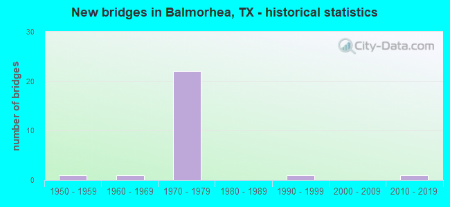
- New bridges - historical statistics
- 11950-1959
- 11960-1969
- 221970-1979
- 11990-1999
- 12010-2019


- Bridge Condition - Superstructure
- 6.7%Very good
- 93.3%Good

- Bridge Condition - Substructure
- 73.3%Good
- 26.7%Satisfactory

- Bridge Condition - Channel
- 68.8%Good
- 25.0%Satisfactory
- 6.3%Fair

- Bridge Condition - Culverts
- 80.0%Good
- 20.0%Satisfactory
Find on map >> Show street view
Structure Number: 61950044104034, Location: 3.60 MI SW OF FM 2903 (Lat: 30.949194, Lng: -103.777611), Route carried "on" structure: State highway 17, Year Built: 1957, Status: Open, Structure Length: 0.94m (3.08ft), Average Daily Traffic: 771 (year 2020), Truck Traffic: 17%, Average Future Daily Traffic: 1,200 (year 2033), Features Intersected: WIENACHT DRAW
Minimum Vertical Clearance: 30+ m (98+ ft), Kilometerpoint: 26.330, Lanes on structure: 2, Owner: State Highway Agency, Approaching Roadway Width: 13.4m (44.0ft), Skew: 3 degrees, Material/Design: Concrete, Design/Construction: Culvert, Number Of Spans In Main Unit: 4, Length of Maximum Span: 1.8m (5.9ft), Curb-To-Curb Width: 13.4m (44.0ft), Out-to-Out Width: 15.2m (49.9ft)
Condition: Channel: Satisfactory, Culverts: Good, Operating Rating: 39.9 metric tons, Method Used To Determine Operating Rating: Load Factor (LF), Inventory Rating: 23.6 metric tons, Method Used To Determine Inventory Rating: Load Factor (LF), Structural Evaluation: Equal to present minimum criteria, Deck Geometry: Superior to present desirable criteria, Waterway Adequacy: Equal to present minimum criteria, Approach Roadway Alignment: Equal to present desirable criteria, Designated Inspection Frequency: Every 24 months, Inspection Date: March 2021, Deck Structure Type: Concrete Cast-file-Place, Wearing Surface/Protective System: Wearing Surface: Bituminous
Find on map >> Show street view
Structure Number: 61950044105132, Location: 0.70 MI E OF FM 2903 (Lat: 31.008256, Lng: -103.741308), Route carried "on" structure: Interstate 10, Year Built: 1974, Status: Open, Structure Length: 2.93m (9.61ft), Average Daily Traffic: 5,450 (year 2020), Truck Traffic: 44%, Average Future Daily Traffic: 7,420 (year 2033), Design Load: HS 20, Features Intersected: DRAIN
Minimum Vertical Clearance: 30+ m (98+ ft), Kilometerpoint: 35.604, Lanes on structure: 6, Owner: State Highway Agency, Approaching Roadway Width: 31.7m (104.0ft), Skew: 24 degrees, Material/Design: Concrete, Design/Construction: Culvert, Number Of Spans In Main Unit: 9, Length of Maximum Span: 2.1m (6.9ft)
Condition: Channel: Satisfactory, Culverts: Satisfactory, Operating Rating: 39.9 metric tons, Method Used To Determine Operating Rating: Load Factor (LF), Inventory Rating: 23.6 metric tons, Method Used To Determine Inventory Rating: Load Factor (LF), Structural Evaluation: Somewhat better than minimum adequacy, Waterway Adequacy: Equal to present minimum criteria, Approach Roadway Alignment: Equal to present desirable criteria, Designated Inspection Frequency: Every 24 months, Inspection Date: Febuary 2021
Find on map >> Show street view
Structure Number: 61950044105133, Location: 1.0 MI E OF FM 2903 (Lat: 31.007456, Lng: -103.736847), Route carried "on" structure: Interstate 10, Year Built: 1974, Status: Open, Structure Length: 1.19m (3.90ft), Average Daily Traffic: 5,734 (year 2019), Truck Traffic: 44%, Average Future Daily Traffic: 7,420 (year 2033), Design Load: HS 20, Features Intersected: DRAIN
Minimum Vertical Clearance: 30+ m (98+ ft), Kilometerpoint: 36.109, Lanes on structure: 6, Owner: State Highway Agency, Approaching Roadway Width: 31.7m (104.0ft), Skew: 20 degrees, Material/Design: Concrete, Design/Construction: Culvert, Number Of Spans In Main Unit: 6, Length of Maximum Span: 1.8m (5.9ft)
Condition: Channel: Good, Culverts: Good, Operating Rating: 39.9 metric tons, Method Used To Determine Operating Rating: Load Factor (LF), Inventory Rating: 23.6 metric tons, Method Used To Determine Inventory Rating: Load Factor (LF), Structural Evaluation: Somewhat better than minimum adequacy, Waterway Adequacy: Equal to present minimum criteria, Approach Roadway Alignment: Equal to present desirable criteria, Designated Inspection Frequency: Every 24 months, Inspection Date: Febuary 2021
Find on map >> Show street view
Structure Number: 61950044105135, Location: 1.30 Mi W of SH 17 (Lat: 31.005689, Lng: -103.724242), Route carried "on" structure: ServiceOther road 10, Year Built: 1974, Status: Open, Structure Length: 6.10m (20.01ft), Average Daily Traffic: 100 (year 2017), Truck Traffic: 55%, Average Future Daily Traffic: 10 (year 2033), Design Load: H 15, Features Intersected: Toyah Creek
Minimum Vertical Clearance: 30+ m (98+ ft), Kilometerpoint: 37.205, Lanes on structure: 2, Owner: State Highway Agency, Approaching Roadway Width: 7.9m (25.9ft), Skew: 3 degrees, Material/Design: Prestressed concrete, Design/Construction: Stringer/Multi-beam, Number Of Spans In Main Unit: 1, Number Of Approach Spans: 2, Length of Maximum Span: 24.1m (79.1ft), Curb-To-Curb Width: 7.9m (25.9ft), Out-to-Out Width: 8.6m (28.2ft)
Condition: Deck: Good, Superstructure: Good, Substructure: Good, Channel: Good, Operating Rating: 49.0 metric tons, Method Used To Determine Operating Rating: Load Factor (LF), Inventory Rating: 23.6 metric tons, Method Used To Determine Inventory Rating: Load Factor (LF), Structural Evaluation: Equal to present minimum criteria, Deck Geometry: Equal to present minimum criteria, Waterway Adequacy: Better than present minimum criteria, Approach Roadway Alignment: Equal to present desirable criteria, Designated Inspection Frequency: Every 24 months, Inspection Date: October 2021, Deck Structure Type: Concrete Cast-file-Place, Wearing Surface/Protective System: Wearing Surface: Bituminous
Find on map >> Show street view
Structure Number: 61950044105136, Location: 1.30 Mi W of SH 17 (Lat: 31.005375, Lng: -103.724547), Route carried "on" structure: Interstate 10, Year Built: 1974, Status: Open, Structure Length: 7.01m (23.00ft), Average Daily Traffic: 2,649 (year 2019), Truck Traffic: 44%, Average Future Daily Traffic: 3,710 (year 2033), Design Load: HS 20, Features Intersected: Toyah Creek & Service Rd
Minimum Vertical Clearance: 30+ m (98+ ft), Kilometerpoint: 37.168, Lanes on structure: 2, Lanes under structure: 2, Owner: State Highway Agency, Approaching Roadway Width: 11.6m (38.1ft), Skew: 3 degrees, Material/Design: Prestressed concrete, Design/Construction: Stringer/Multi-beam, Number Of Spans In Main Unit: 2, Number Of Approach Spans: 1, Length of Maximum Span: 30.2m (99.1ft), Curb-To-Curb Width: 12.8m (42.0ft), Out-to-Out Width: 13.5m (44.3ft)
Condition: Deck: Good, Superstructure: Good, Substructure: Good, Channel: Good, Operating Rating: 54.4 metric tons, Method Used To Determine Operating Rating: Assigned rating based on Load Factor Design (LFD) reported in metric tons, Inventory Rating: 32.7 metric tons, Method Used To Determine Inventory Rating: Assigned rating based on Load Factor Design (LFD) reported in metric tons, Structural Evaluation: Better than present minimum criteria, Deck Geometry: Equal to present desirable criteria, Underclear: High priority of corrective action, Waterway Adequacy: Superior to present desirable criteria, Approach Roadway Alignment: Equal to present desirable criteria, Designated Inspection Frequency: Every 24 months, Inspection Date: October 2021, Deck Structure Type: Concrete Cast-file-Place, Wearing Surface/Protective System: Wearing Surface: Bituminous
Find on map >> Show street view
Structure Number: 61950044105137, Location: 1.30 Mi W of SH 17 (Lat: 31.005203, Lng: -103.725494), Route carried "on" structure: Interstate 10, Year Built: 1974, Status: Open, Structure Length: 7.01m (23.00ft), Average Daily Traffic: 3,085 (year 2019), Truck Traffic: 44%, Average Future Daily Traffic: 3,710 (year 2033), Design Load: HS 20, Features Intersected: Toyah Creek & Service Rd
Minimum Vertical Clearance: 30+ m (98+ ft), Kilometerpoint: 37.152, Lanes on structure: 2, Lanes under structure: 2, Owner: State Highway Agency, Approaching Roadway Width: 11.6m (38.1ft), Skew: 3 degrees, Material/Design: Prestressed concrete, Design/Construction: Stringer/Multi-beam, Number Of Spans In Main Unit: 2, Number Of Approach Spans: 1, Length of Maximum Span: 30.2m (99.1ft), Curb-To-Curb Width: 12.8m (42.0ft), Out-to-Out Width: 13.5m (44.3ft)
Condition: Deck: Good, Superstructure: Good, Substructure: Good, Channel: Satisfactory, Operating Rating: 54.4 metric tons, Method Used To Determine Operating Rating: Assigned rating based on Load Factor Design (LFD) reported in metric tons, Inventory Rating: 32.7 metric tons, Method Used To Determine Inventory Rating: Assigned rating based on Load Factor Design (LFD) reported in metric tons, Structural Evaluation: Better than present minimum criteria, Deck Geometry: Equal to present desirable criteria, Underclear: High priority of corrective action, Waterway Adequacy: Superior to present desirable criteria, Approach Roadway Alignment: Equal to present desirable criteria, Designated Inspection Frequency: Every 24 months, Inspection Date: October 2021, Deck Structure Type: Concrete Cast-file-Place, Wearing Surface/Protective System: Wearing Surface: Bituminous
Find on map >> Show street view
Structure Number: 61950044105138, Location: 0.50 Mi W of SH 17 (Lat: 31.002989, Lng: -103.711025), Route carried "on" structure: Interstate 10, Year Built: 1974, Status: Open, Structure Length: 2.29m (7.51ft), Average Daily Traffic: 2,649 (year 2019), Truck Traffic: 44%, Average Future Daily Traffic: 3,710 (year 2033), Design Load: HS 20, Features Intersected: Carrasco Draw
Minimum Vertical Clearance: 30+ m (98+ ft), Kilometerpoint: 38.536, Lanes on structure: 2, Owner: State Highway Agency, Approaching Roadway Width: 11.6m (38.1ft), Material/Design: Concrete continuous, Design/Construction: Slab, Number Of Spans In Main Unit: 3, Length of Maximum Span: 7.6m (24.9ft), Curb-To-Curb Width: 12.8m (42.0ft), Out-to-Out Width: 13.5m (44.3ft)
Condition: Deck: Good, Superstructure: Good, Substructure: Good, Channel: Good, Operating Rating: 54.4 metric tons, Method Used To Determine Operating Rating: Assigned rating based on Load Factor Design (LFD) reported in metric tons, Inventory Rating: 32.7 metric tons, Method Used To Determine Inventory Rating: Assigned rating based on Load Factor Design (LFD) reported in metric tons, Structural Evaluation: Better than present minimum criteria, Deck Geometry: Equal to present desirable criteria, Waterway Adequacy: Superior to present desirable criteria, Approach Roadway Alignment: Equal to present desirable criteria, Designated Inspection Frequency: Every 24 months, Inspection Date: October 2021, Deck Structure Type: Concrete Cast-file-Place, Wearing Surface/Protective System: Wearing Surface: Bituminous
Find on map >> Show street view
Structure Number: 61950044105139, Location: 0.50 Mi W of SH 17 (Lat: 31.002747, Lng: -103.711264), Route carried "on" structure: Interstate 10, Year Built: 1974, Status: Open, Structure Length: 2.29m (7.51ft), Average Daily Traffic: 3,085 (year 2019), Truck Traffic: 44%, Average Future Daily Traffic: 3,710 (year 2033), Design Load: HS 20, Features Intersected: Carrasco Draw
Minimum Vertical Clearance: 30+ m (98+ ft), Kilometerpoint: 38.536, Lanes on structure: 2, Owner: State Highway Agency, Approaching Roadway Width: 11.6m (38.1ft), Material/Design: Concrete continuous, Design/Construction: Slab, Number Of Spans In Main Unit: 3, Length of Maximum Span: 7.6m (24.9ft), Curb-To-Curb Width: 12.8m (42.0ft), Out-to-Out Width: 13.5m (44.3ft)
Condition: Deck: Good, Superstructure: Good, Substructure: Good, Channel: Good, Operating Rating: 54.4 metric tons, Method Used To Determine Operating Rating: Assigned rating based on Load Factor Design (LFD) reported in metric tons, Inventory Rating: 32.7 metric tons, Method Used To Determine Inventory Rating: Assigned rating based on Load Factor Design (LFD) reported in metric tons, Structural Evaluation: Better than present minimum criteria, Deck Geometry: Equal to present desirable criteria, Waterway Adequacy: Superior to present desirable criteria, Approach Roadway Alignment: Equal to present desirable criteria, Designated Inspection Frequency: Every 24 months, Inspection Date: October 2021, Deck Structure Type: Concrete Cast-file-Place, Wearing Surface/Protective System: Wearing Surface: Bituminous
Find on map >> Show street view
Structure Number: 6195004410514, Location: 4.45 Mi W of FM 2448 (Lat: 31.001478, Lng: -103.702989), Route carried "on" structure: Interstate 10, Year Built: 1974, Status: Open, Structure Length: 6.71m (22.01ft), Average Daily Traffic: 3,465 (year 2019), Truck Traffic: 44%, Average Future Daily Traffic: 3,710 (year 2033), Design Load: HS 20, Features Intersected: SH 17 (IH 10 BUS F)
Minimum Vertical Clearance: 30+ m (98+ ft), Kilometerpoint: 39.300, Lanes on structure: 2, Lanes under structure: 2, Owner: State Highway Agency, Approaching Roadway Width: 11.6m (38.1ft), Material/Design: Prestressed concrete, Design/Construction: Stringer/Multi-beam, Number Of Spans In Main Unit: 3, Length of Maximum Span: 24.4m (80.1ft), Curb-To-Curb Width: 12.8m (42.0ft), Out-to-Out Width: 13.5m (44.3ft)
Condition: Deck: Good, Superstructure: Good, Substructure: Satisfactory, Operating Rating: 68.0 metric tons, Method Used To Determine Operating Rating: Load Factor (LF), Inventory Rating: 33.6 metric tons, Method Used To Determine Inventory Rating: Load Factor (LF), Structural Evaluation: Equal to present minimum criteria, Deck Geometry: Equal to present desirable criteria, Underclear: Superior to present desirable criteria, Approach Roadway Alignment: Equal to present desirable criteria, Designated Inspection Frequency: Every 24 months, Inspection Date: October 2021, Deck Structure Type: Concrete Cast-file-Place, Wearing Surface/Protective System: Wearing Surface: Bituminous
Find on map >> Show street view
Structure Number: 61950044105141, Location: 4.45 Mi W of FM 2448 (Lat: 31.001303, Lng: -103.703036), Route carried "on" structure: Interstate 10, Year Built: 1974, Status: Open, Structure Length: 6.71m (22.01ft), Average Daily Traffic: 3,580 (year 2019), Truck Traffic: 44%, Average Future Daily Traffic: 3,710 (year 2033), Design Load: HS 20, Features Intersected: SH 17 (IH 10 BUS F)
Minimum Vertical Clearance: 30+ m (98+ ft), Kilometerpoint: 39.300, Lanes on structure: 2, Lanes under structure: 2, Owner: State Highway Agency, Approaching Roadway Width: 11.6m (38.1ft), Material/Design: Prestressed concrete, Design/Construction: Stringer/Multi-beam, Number Of Spans In Main Unit: 3, Length of Maximum Span: 24.4m (80.1ft), Curb-To-Curb Width: 12.8m (42.0ft), Out-to-Out Width: 13.5m (44.3ft)
Condition: Deck: Good, Superstructure: Good, Substructure: Satisfactory, Operating Rating: 68.0 metric tons, Method Used To Determine Operating Rating: Load Factor (LF), Inventory Rating: 33.6 metric tons, Method Used To Determine Inventory Rating: Load Factor (LF), Structural Evaluation: Equal to present minimum criteria, Deck Geometry: Equal to present desirable criteria, Underclear: Superior to present desirable criteria, Approach Roadway Alignment: Equal to present desirable criteria, Designated Inspection Frequency: Every 24 months, Inspection Date: October 2021, Deck Structure Type: Concrete Cast-file-Place, Wearing Surface/Protective System: Wearing Surface: Bituminous
Find on map >> Show street view
Structure Number: 61950044109124, Location: 1.60 MI W OF FM 2903 (Lat: 31.011719, Lng: -103.780472), Route carried "on" structure: Interstate 10, Year Built: 1974, Status: Open, Structure Length: 3.20m (10.50ft), Average Daily Traffic: 2,731 (year 2019), Truck Traffic: 44%, Average Future Daily Traffic: 3,410 (year 2033), Design Load: HS 20, Features Intersected: EVERITT DRAW
Minimum Vertical Clearance: 30+ m (98+ ft), Kilometerpoint: 31.896, Lanes on structure: 1, Owner: State Highway Agency, Approaching Roadway Width: 11.9m (39.0ft), Skew: 4 degrees, Material/Design: Concrete, Design/Construction: Slab, Number Of Spans In Main Unit: 4, Length of Maximum Span: 7.9m (25.9ft), Curb-To-Curb Width: 8.0m (26.2ft), Out-to-Out Width: 13.5m (44.3ft)
Condition: Deck: Good, Superstructure: Good, Substructure: Satisfactory, Channel: Good, Operating Rating: 39.0 metric tons, Method Used To Determine Operating Rating: Load Factor (LF), Inventory Rating: 23.6 metric tons, Method Used To Determine Inventory Rating: Load Factor (LF), Structural Evaluation: Somewhat better than minimum adequacy, Deck Geometry: High priority of corrective action, Waterway Adequacy: Equal to present minimum criteria, Approach Roadway Alignment: Equal to present desirable criteria, Designated Inspection Frequency: Every 24 months, Inspection Date: July 2020, Deck Structure Type: Concrete Cast-file-Place, Wearing Surface/Protective System: Wearing Surface: Bituminous
Find on map >> Show street view
Structure Number: 61950044109125, Location: 1.60 MI W OF FM 2903 (Lat: 31.011536, Lng: -103.780489), Route carried "on" structure: Interstate 10, Year Built: 1974, Status: Open, Structure Length: 3.20m (10.50ft), Average Daily Traffic: 3,114 (year 2019), Truck Traffic: 44%, Average Future Daily Traffic: 3,410 (year 2033), Design Load: HS 20, Features Intersected: EVERITT DRAW
Minimum Vertical Clearance: 30+ m (98+ ft), Kilometerpoint: 31.896, Lanes on structure: 1, Owner: State Highway Agency, Approaching Roadway Width: 11.7m (38.4ft), Skew: 4 degrees, Material/Design: Concrete, Design/Construction: Slab, Number Of Spans In Main Unit: 4, Length of Maximum Span: 7.9m (25.9ft), Curb-To-Curb Width: 7.7m (25.3ft), Out-to-Out Width: 13.5m (44.3ft)
Condition: Deck: Good, Superstructure: Good, Substructure: Good, Channel: Good, Operating Rating: 39.0 metric tons, Method Used To Determine Operating Rating: Load Factor (LF), Inventory Rating: 23.6 metric tons, Method Used To Determine Inventory Rating: Load Factor (LF), Structural Evaluation: Somewhat better than minimum adequacy, Deck Geometry: High priority of replacement, Waterway Adequacy: Equal to present minimum criteria, Approach Roadway Alignment: Equal to present desirable criteria, Designated Inspection Frequency: Every 24 months, Inspection Date: July 2020, Deck Structure Type: Concrete Cast-file-Place, Wearing Surface/Protective System: Wearing Surface: Bituminous
Find on map >> Show street view
Structure Number: 61950044109126, Location: 1.00 MI W OF FM 2903 (Lat: 31.010808, Lng: -103.769542), Route carried "on" structure: Interstate 10, Year Built: 1974, Status: Open, Structure Length: 2.32m (7.61ft), Average Daily Traffic: 2,731 (year 2019), Truck Traffic: 44%, Average Future Daily Traffic: 3,410 (year 2033), Design Load: HS 20, Features Intersected: WEINACHT DRAW
Minimum Vertical Clearance: 30+ m (98+ ft), Kilometerpoint: 32.945, Lanes on structure: 2, Owner: State Highway Agency, Approaching Roadway Width: 12.3m (40.4ft), Skew: 3 degrees, Material/Design: Concrete, Design/Construction: Slab, Number Of Spans In Main Unit: 3, Length of Maximum Span: 7.6m (24.9ft), Curb-To-Curb Width: 12.7m (41.7ft), Out-to-Out Width: 13.5m (44.3ft)
Condition: Deck: Good, Superstructure: Good, Substructure: Good, Channel: Good, Operating Rating: 44.4 metric tons, Method Used To Determine Operating Rating: Load Factor (LF), Inventory Rating: 26.3 metric tons, Method Used To Determine Inventory Rating: Load Factor (LF), Structural Evaluation: Equal to present minimum criteria, Deck Geometry: Better than present minimum criteria, Waterway Adequacy: Superior to present desirable criteria, Approach Roadway Alignment: Equal to present desirable criteria, Designated Inspection Frequency: Every 24 months, Inspection Date: July 2020, Deck Structure Type: Concrete Cast-file-Place, Wearing Surface/Protective System: Wearing Surface: Bituminous
Find on map >> Show street view
Structure Number: 61950044109127, Location: 1.00 MI W OF FM 2903 (Lat: 31.010625, Lng: -103.769547), Route carried "on" structure: Interstate 10, Year Built: 1974, Status: Open, Structure Length: 2.32m (7.61ft), Average Daily Traffic: 3,114 (year 2019), Truck Traffic: 44%, Average Future Daily Traffic: 3,410 (year 2033), Design Load: HS 20, Features Intersected: WEINACHT DRAW
Minimum Vertical Clearance: 30+ m (98+ ft), Kilometerpoint: 32.945, Lanes on structure: 2, Owner: State Highway Agency, Approaching Roadway Width: 12.2m (40.0ft), Skew: 3 degrees, Material/Design: Concrete, Design/Construction: Slab, Number Of Spans In Main Unit: 3, Length of Maximum Span: 7.6m (24.9ft), Curb-To-Curb Width: 12.7m (41.7ft), Out-to-Out Width: 13.5m (44.3ft)
Condition: Deck: Good, Superstructure: Good, Substructure: Good, Channel: Good, Operating Rating: 44.4 metric tons, Method Used To Determine Operating Rating: Load Factor (LF), Inventory Rating: 26.3 metric tons, Method Used To Determine Inventory Rating: Load Factor (LF), Structural Evaluation: Equal to present minimum criteria, Deck Geometry: Better than present minimum criteria, Waterway Adequacy: Superior to present desirable criteria, Approach Roadway Alignment: Equal to present desirable criteria, Designated Inspection Frequency: Every 24 months, Inspection Date: July 2020, Deck Structure Type: Concrete Cast-file-Place, Wearing Surface/Protective System: Wearing Surface: Bituminous
Find on map >> Show street view
Structure Number: 61950044109128, Location: AT INT OF IH 10 & FM 2903 (Lat: 31.008917, Lng: -103.753131), Route carried "on" structure: State highway 10, Year Built: 1974, Status: Open, Structure Length: 9.75m (31.99ft), Average Daily Traffic: 774 (year 2017), Truck Traffic: 6%, Average Future Daily Traffic: 360 (year 2033), Design Load: HS 20, Features Intersected: IH 10
Minimum Vertical Clearance: 30+ m (98+ ft), Kilometerpoint: 35.843, Lanes on structure: 2, Lanes under structure: 4, Owner: State Highway Agency, Approaching Roadway Width: 12.2m (40.0ft), Material/Design: Prestressed concrete, Design/Construction: Stringer/Multi-beam, Number Of Spans In Main Unit: 2, Number Of Approach Spans: 2, Length of Maximum Span: 35.1m (115.2ft), Curb-To-Curb Width: 12.2m (40.0ft), Out-to-Out Width: 12.9m (42.3ft)
Condition: Deck: Good, Superstructure: Good, Substructure: Good, Operating Rating: 54.4 metric tons, Method Used To Determine Operating Rating: Assigned rating based on Load Factor Design (LFD) reported in metric tons, Inventory Rating: 32.7 metric tons, Method Used To Determine Inventory Rating: Assigned rating based on Load Factor Design (LFD) reported in metric tons, Structural Evaluation: Better than present minimum criteria, Deck Geometry: Equal to present desirable criteria, Underclear: Equal to present minimum criteria, Approach Roadway Alignment: Equal to present desirable criteria, Designated Inspection Frequency: Every 24 months, Inspection Date: July 2020, Deck Structure Type: Concrete Cast-file-Place, Wearing Surface/Protective System: Wearing Surface: Bituminous
Find on map >> Show street view
Structure Number: 61950044109129, Location: 0.30 MI E OF FM 2903 (Lat: 31.008953, Lng: -103.748372), Route carried "on" structure: Interstate 10, Year Built: 1974, Status: Open, Structure Length: 0.98m (3.22ft), Average Daily Traffic: 5,450 (year 2020), Truck Traffic: 44%, Average Future Daily Traffic: 7,420 (year 2033), Design Load: HS 20, Features Intersected: DRAIN
Minimum Vertical Clearance: 30+ m (98+ ft), Kilometerpoint: 34.924, Lanes on structure: 8, Owner: State Highway Agency, Approaching Roadway Width: 47.5m (155.8ft), Skew: 24 degrees, Material/Design: Concrete, Design/Construction: Culvert, Number Of Spans In Main Unit: 4, Length of Maximum Span: 1.5m (4.9ft)
Condition: Channel: Good, Culverts: Good, Operating Rating: 39.9 metric tons, Method Used To Determine Operating Rating: Load Factor (LF), Inventory Rating: 23.6 metric tons, Method Used To Determine Inventory Rating: Load Factor (LF), Structural Evaluation: Somewhat better than minimum adequacy, Waterway Adequacy: Equal to present minimum criteria, Approach Roadway Alignment: Equal to present desirable criteria, Designated Inspection Frequency: Every 24 months, Inspection Date: Febuary 2021
Find on map >> Show street view
Structure Number: 61950044109131, Location: 2.60 MI W OF FM 2903 (Lat: 31.011811, Lng: -103.796958), Route carried "on" structure: Interstate 10, Year Built: 1974, Status: Open, Structure Length: 0.70m (2.30ft), Average Daily Traffic: 6,165 (year 2020), Truck Traffic: 44%, Average Future Daily Traffic: 6,830 (year 2033), Features Intersected: CR 327
Minimum Vertical Clearance: 30+ m (98+ ft), Kilometerpoint: 30.277, Lanes on structure: 4, Lanes under structure: 1, Owner: State Highway Agency, Approaching Roadway Width: 23.2m (76.1ft), Skew: 20 degrees, Material/Design: Steel, Design/Construction: Culvert, Number Of Spans In Main Unit: 1, Length of Maximum Span: 6.1m (20.0ft), Curb-To-Curb Width: 23.2m (76.1ft), Out-to-Out Width: 71.6m (234.9ft)
Condition: Culverts: Good, Operating Rating: 39.9 metric tons, Method Used To Determine Operating Rating: Load Factor (LF), Inventory Rating: 23.6 metric tons, Method Used To Determine Inventory Rating: Load Factor (LF), Structural Evaluation: Somewhat better than minimum adequacy, Deck Geometry: Superior to present desirable criteria, Underclear: High priority of corrective action, Approach Roadway Alignment: Equal to present desirable criteria, Designated Inspection Frequency: Every 24 months, Inspection Date: July 2020, Deck Structure Type: Concrete Cast-file-Place, Wearing Surface/Protective System: Wearing Surface: Bituminous
Find on map >> Show street view
Structure Number: 61950245103009, Location: 5.9 MI W OF US 285 (Lat: 31.822617, Lng: -104.008678), Route carried "on" structure: State highway 652, Year Built: 2018, Status: Open, Structure Length: 12.80m (41.99ft), Average Daily Traffic: 1,470 (year 2013), Truck Traffic: 11%, Average Future Daily Traffic: 2,060 (year 2033), Design Load: HL 93, Features Intersected: Salt Creek
Minimum Vertical Clearance: 30+ m (98+ ft), Kilometerpoint: 3.109, Lanes on structure: 2, Owner: State Highway Agency, Approaching Roadway Width: 11.0m (36.1ft), Material/Design: Prestressed concrete, Design/Construction: Stringer/Multi-beam, Number Of Spans In Main Unit: 3, Number Of Approach Spans: 3, Length of Maximum Span: 24.4m (80.1ft), Curb-To-Curb Width: 13.2m (43.3ft), Out-to-Out Width: 14.0m (45.9ft)
Condition: Deck: Good, Superstructure: Good, Substructure: Satisfactory, Channel: Satisfactory, Operating Rating: 54.4 metric tons, Method Used To Determine Operating Rating: Assigned ratings based on Load and Resistance Factor Design (LRFD) reported in metric tons, Inventory Rating: 32.7 metric tons, Method Used To Determine Inventory Rating: Assigned ratings based on Load and Resistance Factor Design (LRFD) reported in metric tons, Structural Evaluation: Equal to present minimum criteria, Deck Geometry: Better than present minimum criteria, Waterway Adequacy: Superior to present desirable criteria, Approach Roadway Alignment: Equal to present desirable criteria, Designated Inspection Frequency: Every 24 months, Inspection Date: October 2021, Deck Structure Type: Concrete Precast Panels
Find on map >> Show street view
Structure Number: 61950296802009, Location: 1.75 MI S of IH 10 (Lat: 30.987794, Lng: -103.744567), Route carried "on" structure: Business State highway 10, Year Built: 1968, Status: Open, Structure Length: 9.14m (29.99ft), Average Daily Traffic: 369 (year 2020), Truck Traffic: 11%, Average Future Daily Traffic: 490 (year 2033), Design Load: H 20, Features Intersected: Toyah Creek
Minimum Vertical Clearance: 30+ m (98+ ft), Kilometerpoint: 38.676, Lanes on structure: 2, Owner: State Highway Agency, Approaching Roadway Width: 10.1m (33.1ft), Material/Design: Concrete, Design/Construction: Slab, Number Of Spans In Main Unit: 12, Length of Maximum Span: 7.6m (24.9ft), Curb-To-Curb Width: 10.1m (33.1ft), Out-to-Out Width: 10.8m (35.4ft)
Condition: Deck: Good, Superstructure: Good, Substructure: Good, Channel: Good, Operating Rating: 57.1 metric tons, Method Used To Determine Operating Rating: Load Factor (LF), Inventory Rating: 34.5 metric tons, Method Used To Determine Inventory Rating: Load Factor (LF), Structural Evaluation: Better than present minimum criteria, Deck Geometry: Better than present minimum criteria, Waterway Adequacy: Better than present minimum criteria, Approach Roadway Alignment: Equal to present desirable criteria, Designated Inspection Frequency: Every 24 months, Inspection Date: October 2021, Deck Structure Type: Concrete Cast-file-Place, Wearing Surface/Protective System: Wearing Surface: Bituminous
Find on map >> Show street view
Structure Number: 61950AA0183001, Location: 0.80 Mi SE of CR 323 (Lat: 30.949356, Lng: -103.756364), Route carried "on" structure: County highway 324, Year Built: 1994, Status: Open, Structure Length: 2.74m (8.99ft), Average Daily Traffic: 100 (year 2017), Average Future Daily Traffic: 30 (year 2035), Design Load: HS 20, Features Intersected: Madera Diversion Channel
Minimum Vertical Clearance: 30+ m (98+ ft), Kilometerpoint: 1.368, Lanes on structure: 2, Owner: County Highway Agency, Approaching Roadway Width: 6.1m (20.0ft), Material/Design: Prestressed concrete, Design/Construction: Stringer/Multi-beam, Number Of Spans In Main Unit: 2, Length of Maximum Span: 13.4m (44.0ft), Curb-To-Curb Width: 7.3m (24.0ft), Out-to-Out Width: 7.9m (25.9ft)
Condition: Deck: Good, Superstructure: Very good, Substructure: Good, Channel: Fair, Operating Rating: 54.4 metric tons, Method Used To Determine Operating Rating: Assigned rating based on Load Factor Design (LFD) reported in metric tons, Inventory Rating: 32.7 metric tons, Method Used To Determine Inventory Rating: Assigned rating based on Load Factor Design (LFD) reported in metric tons, Structural Evaluation: Better than present minimum criteria, Deck Geometry: Equal to present minimum criteria, Waterway Adequacy: Better than present minimum criteria, Approach Roadway Alignment: Somewhat better than minimum adequacy, Designated Inspection Frequency: Every 24 months, Inspection Date: October 2021, Deck Structure Type: Concrete Precast Panels
Find on map >> Show street view
Structure Number: 61950044105136, Location: 1.30 Mi W of SH 17 (Lat: 31.005375, Lng: -103.724547), Route carried "under" structure: ServiceState highway , Year Built: 1974, Structure Length: 0. m, Average Daily Traffic: 4,900 (year 2015), Features Intersected: None, Facility Carried by Structure: IH 10 WB
Minimum Vertical Clearance: 2.87m (9.42ft), Kilometerpoint: 41.299, Material/Design: Prestressed concrete, Design/Construction: Stringer/Multi-beam, Length of Maximum Span: 30.2m (99.1ft)
Find on map >> Show street view
Structure Number: 61950044105137, Location: 1.30 Mi W of SH 17 (Lat: 31.005203, Lng: -103.725494), Route carried "under" structure: ServiceState highway , Year Built: 1974, Structure Length: 0. m, Average Daily Traffic: 4,900 (year 2015), Features Intersected: None, Facility Carried by Structure: IH 10 EB
Minimum Vertical Clearance: 3.33m (10.93ft), Kilometerpoint: 41.299, Material/Design: Prestressed concrete, Design/Construction: Stringer/Multi-beam, Length of Maximum Span: 30.2m (99.1ft)
Find on map >> Show street view
Structure Number: 6195004410514, Location: 4.45 Mi W of FM 2448 (Lat: 31.001478, Lng: -103.702989), Route carried "under" structure: State highway 17, Year Built: 1974, Structure Length: 0. m, Average Daily Traffic: 1,170 (year 2011), Truck Traffic: 10%, Features Intersected: None, Facility Carried by Structure: IH 10 WB
Minimum Vertical Clearance: 5.33m (17.49ft), Kilometerpoint: 16.150, Material/Design: Prestressed concrete, Design/Construction: Stringer/Multi-beam, Length of Maximum Span: 24.4m (80.1ft)
Find on map >> Show street view
Structure Number: 61950044105141, Location: 4.45 Mi W of FM 2448 (Lat: 31.001303, Lng: -103.703036), Route carried "under" structure: State highway 17, Year Built: 1974, Structure Length: 0. m, Average Daily Traffic: 1,170 (year 2011), Truck Traffic: 10%, Features Intersected: None, Facility Carried by Structure: IH 10 EB
Minimum Vertical Clearance: 5.33m (17.49ft), Kilometerpoint: 16.179, Material/Design: Prestressed concrete, Design/Construction: Stringer/Multi-beam, Length of Maximum Span: 24.4m (80.1ft)
Find on map >> Show street view
Structure Number: 61950044109128, Location: AT INT OF IH 10 & FM 2903 (Lat: 31.008917, Lng: -103.753131), Route carried "under" structure: Interstate 10, Year Built: 1974, Structure Length: 0. m, Average Daily Traffic: 4,880 (year 2013), Truck Traffic: 44%, Features Intersected: IH 10
Minimum Vertical Clearance: 5.31m (17.42ft), Kilometerpoint: 34.474, Lanes on structure: 2, Lanes under structure: 4, Material/Design: Prestressed concrete, Design/Construction: Stringer/Multi-beam, Length of Maximum Span: 35.1m (115.2ft)
Find on map >> Show street view
Structure Number: 61950044109131, Location: 2.60 MI W OF FM 2903 (Lat: 31.011811, Lng: -103.796958), Route carried "under" structure: County highway 327, Year Built: 1974, Structure Length: 0. m, Average Daily Traffic: 10 (year 2010), Features Intersected: CO RD 327, Facility Carried by Structure: IH 10 ML
Minimum Vertical Clearance: 3.51m (11.52ft), Kilometerpoint: 0.000, Lanes on structure: 4, Lanes under structure: 1, Material/Design: Steel, Design/Construction: Culvert, Length of Maximum Span: 6.1m (20.0ft)