Bridge Statistics for Bandera, Texas (TX)
Condition, Traffic, Stress, Structural Evaluation, Project Costs
- National Bridge Inventory (NBI) Statistics
- 13Number of bridges
- 187ft / 56.9mTotal length
- $9,000Total costs
- 68,582Total average daily traffic
- 4,528Total average daily truck traffic
- 75,340Total future (year 2032) average daily traffic
- National Bridge Inventory (NBI) Registered Bridges for Bandera
- No street view available for this location
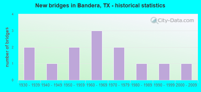
- New bridges - historical statistics
- 21930-1939
- 11940-1949
- 21950-1959
- 31960-1969
- 21970-1979
- 11980-1989
- 11990-1999
- 12000-2009
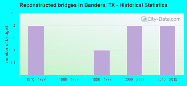
- Reconstructed bridges - Historical Statistics
- 21970-1979
- 01980-1989
- 11990-1999
- 22000-2009
- 22010-2019
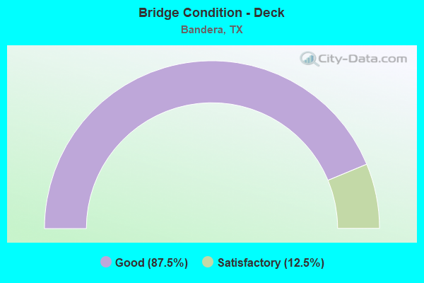
- Bridge Condition - Deck
- 87.5%Good
- 12.5%Satisfactory
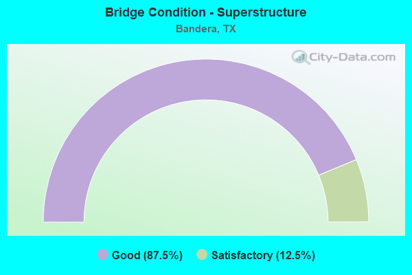
- Bridge Condition - Superstructure
- 87.5%Good
- 12.5%Satisfactory
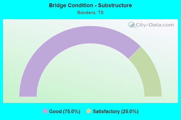
- Bridge Condition - Substructure
- 75.0%Good
- 25.0%Satisfactory
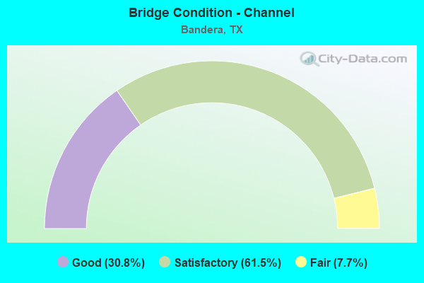
- Bridge Condition - Channel
- 30.8%Good
- 61.5%Satisfactory
- 7.7%Fair
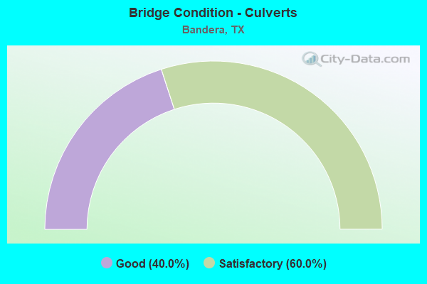
- Bridge Condition - Culverts
- 40.0%Good
- 60.0%Satisfactory
Find on map >> Show street view
Structure Number: 150100029104055, Location: 2.6 MI SW OF KERR CO LN (Lat: 29.877669, Lng: -99.286389), Route carried "on" structure: State highway 16, Year Built: 1944, Year Reconstructed: 2016, Status: Open, Structure Length: 0.67m (2.20ft), Average Daily Traffic: 612 (year 2020), Truck Traffic: 12%, Average Future Daily Traffic: 740 (year 2033), Design Load: H 15, Features Intersected: WALLACE CREEK
Minimum Vertical Clearance: 30+ m (98+ ft), Kilometerpoint: 5.768, Lanes on structure: 2, Owner: State Highway Agency, Approaching Roadway Width: 7.3m (24.0ft), Skew: 3 degrees, Material/Design: Concrete, Design/Construction: Culvert, Number Of Spans In Main Unit: 3, Length of Maximum Span: 1.8m (5.9ft), Curb-To-Curb Width: 10.6m (34.8ft), Out-to-Out Width: 12.1m (39.7ft)
Condition: Channel: Good, Culverts: Good, Operating Rating: 32.7 metric tons, Method Used To Determine Operating Rating: Field evaluation and documented engineering judgment, Inventory Rating: 24.5 metric tons, Method Used To Determine Inventory Rating: Field evaluation and documented engineering judgment, Structural Evaluation: Equal to present minimum criteria, Deck Geometry: Equal to present minimum criteria, Waterway Adequacy: High priority of corrective action, Approach Roadway Alignment: High priority of corrective action, Length Of Structure Improvement: 0.70m (2.30ft), Designated Inspection Frequency: Every 24 months, Inspection Date: May 2020, Bridge Improvement Cost: $1,000, Total Project Cost: $1,000, Deck Structure Type: Concrete Cast-file-Place, Wearing Surface/Protective System: Wearing Surface: Bituminous
Find on map >> Show street view
Structure Number: 150100029105046, Location: 1.0 MI W OF SH 173 (Lat: 29.731067, Lng: -99.094336), Route carried "on" structure: State highway 16, Year Built: 1936, Year Reconstructed: 2017, Status: Open, Structure Length: 0.70m (2.30ft), Average Daily Traffic: 5,976 (year 2020), Truck Traffic: 8%, Average Future Daily Traffic: 5,710 (year 2033), Design Load: H 15, Features Intersected: DRAW
Minimum Vertical Clearance: 30+ m (98+ ft), Kilometerpoint: 21.181, Lanes on structure: 2, Owner: State Highway Agency, Approaching Roadway Width: 12.8m (42.0ft), Material/Design: Concrete, Design/Construction: Culvert, Number Of Spans In Main Unit: 4, Length of Maximum Span: 1.5m (4.9ft), Curb-To-Curb Width: 16.2m (53.1ft), Out-to-Out Width: 20.6m (67.6ft)
Condition: Channel: Good, Culverts: Satisfactory, Operating Rating: 32.7 metric tons, Method Used To Determine Operating Rating: Field evaluation and documented engineering judgment, Inventory Rating: 24.5 metric tons, Method Used To Determine Inventory Rating: Field evaluation and documented engineering judgment, Structural Evaluation: Equal to present minimum criteria, Deck Geometry: Superior to present desirable criteria, Waterway Adequacy: Equal to present minimum criteria, Approach Roadway Alignment: Equal to present desirable criteria, Designated Inspection Frequency: Every 24 months, Inspection Date: May 2020, Deck Structure Type: Concrete Cast-file-Place, Wearing Surface/Protective System: Wearing Surface: Bituminous
Find on map >> Show street view
Structure Number: 150100029105122, Location: 0.55 MI W OF FM 470 (Lat: 29.736178, Lng: -99.122228), Route carried "on" structure: State highway 16, Year Built: 1984, Status: Open, Structure Length: 13.72m (45.01ft), Average Daily Traffic: 2,267 (year 2020), Truck Traffic: 10%, Average Future Daily Traffic: 1,910 (year 2033), Design Load: HS 20, Features Intersected: MEDINA RIVER
Minimum Vertical Clearance: 30+ m (98+ ft), Kilometerpoint: 18.229, Lanes on structure: 2, Owner: State Highway Agency, Approaching Roadway Width: 12.2m (40.0ft), Skew: 3 degrees, Material/Design: Prestressed concrete, Design/Construction: Stringer/Multi-beam, Number Of Spans In Main Unit: 6, Length of Maximum Span: 22.9m (75.1ft), Curb-To-Curb Width: 12.2m (40.0ft), Out-to-Out Width: 12.8m (42.0ft)
Condition: Deck: Good, Superstructure: Good, Substructure: Good, Channel: Good, Operating Rating: 54.4 metric tons, Method Used To Determine Operating Rating: Assigned rating based on Load Factor Design (LFD) reported in metric tons, Inventory Rating: 32.7 metric tons, Method Used To Determine Inventory Rating: Assigned rating based on Load Factor Design (LFD) reported in metric tons, Structural Evaluation: Better than present minimum criteria, Deck Geometry: Equal to present minimum criteria, Waterway Adequacy: Equal to present minimum criteria, Approach Roadway Alignment: Better than present minimum criteria, Designated Inspection Frequency: Every 24 months, Inspection Date: May 2020, Deck Structure Type: Concrete Cast-file-Place, Wearing Surface/Protective System: Wearing Surface: Bituminous
Find on map >> Show street view
Structure Number: 150100029106019, Location: 2.3 MI NE OF SH 173 (Lat: 29.738444, Lng: -99.035614), Route carried "on" structure: State highway 16, Year Built: 1936, Year Reconstructed: 1982, Status: Open, Structure Length: 0.98m (3.22ft), Average Daily Traffic: 11,033 (year 2020), Truck Traffic: 5%, Average Future Daily Traffic: 12,970 (year 2033), Features Intersected: DREAN CREEK
Minimum Vertical Clearance: 30+ m (98+ ft), Kilometerpoint: 5.510, Lanes on structure: 4, Owner: State Highway Agency, Approaching Roadway Width: 14.6m (47.9ft), Material/Design: Concrete, Design/Construction: Culvert, Number Of Spans In Main Unit: 7, Length of Maximum Span: 1.2m (3.9ft)
Condition: Channel: Satisfactory, Culverts: Satisfactory, Operating Rating: 39.9 metric tons, Method Used To Determine Operating Rating: Load Factor (LF), Inventory Rating: 23.6 metric tons, Method Used To Determine Inventory Rating: Load Factor (LF), Structural Evaluation: Somewhat better than minimum adequacy, Waterway Adequacy: Equal to present minimum criteria, Approach Roadway Alignment: Equal to present desirable criteria, Designated Inspection Frequency: Every 24 months, Inspection Date: May 2020
Find on map >> Show street view
Structure Number: 150100029106077, Location: 0.35 MI NE OF SH 173 (Lat: 29.728747, Lng: -99.066561), Route carried "on" structure: State highway 16, Year Built: 1965, Year Reconstructed: 1982, Status: Open, Structure Length: 1.13m (3.71ft), Average Daily Traffic: 11,033 (year 2020), Truck Traffic: 5%, Average Future Daily Traffic: 12,970 (year 2033), Design Load: HS 20, Features Intersected: MUD CREEK
Minimum Vertical Clearance: 30+ m (98+ ft), Kilometerpoint: 2.232, Lanes on structure: 4, Owner: State Highway Agency, Approaching Roadway Width: 26.2m (86.0ft), Skew: 9 degrees, Material/Design: Concrete, Design/Construction: Culvert, Number Of Spans In Main Unit: 4, Length of Maximum Span: 2.4m (7.9ft)
Condition: Channel: Satisfactory, Culverts: Good, Operating Rating: 39.9 metric tons, Method Used To Determine Operating Rating: Load Factor (LF), Inventory Rating: 23.6 metric tons, Method Used To Determine Inventory Rating: Load Factor (LF), Structural Evaluation: Somewhat better than minimum adequacy, Waterway Adequacy: Equal to present minimum criteria, Approach Roadway Alignment: Equal to present desirable criteria, Designated Inspection Frequency: Every 24 months, Inspection Date: May 2020
Find on map >> Show street view
Structure Number: 150100029106101, Location: 1.2 MI NE OF SH 173 (Lat: 29.731964, Lng: -99.054153), Route carried "on" structure: State highway 16, Year Built: 1978, Status: Open, Structure Length: 6.10m (20.01ft), Average Daily Traffic: 11,033 (year 2020), Truck Traffic: 5%, Average Future Daily Traffic: 12,970 (year 2033), Design Load: HS 20, Features Intersected: BANDERA CREEK
Minimum Vertical Clearance: 30+ m (98+ ft), Kilometerpoint: 3.589, Lanes on structure: 2, Owner: State Highway Agency, Approaching Roadway Width: 13.4m (44.0ft), Skew: 3 degrees, Material/Design: Prestressed concrete, Design/Construction: Stringer/Multi-beam, Number Of Spans In Main Unit: 1, Number Of Approach Spans: 2, Length of Maximum Span: 24.4m (80.1ft), Curb-To-Curb Width: 13.4m (44.0ft), Out-to-Out Width: 14.1m (46.3ft)
Condition: Deck: Good, Superstructure: Good, Substructure: Good, Channel: Good, Operating Rating: 54.4 metric tons, Method Used To Determine Operating Rating: Assigned rating based on Load Factor Design (LFD) reported in metric tons, Inventory Rating: 32.7 metric tons, Method Used To Determine Inventory Rating: Assigned rating based on Load Factor Design (LFD) reported in metric tons, Structural Evaluation: Better than present minimum criteria, Deck Geometry: Equal to present minimum criteria, Waterway Adequacy: Equal to present minimum criteria, Approach Roadway Alignment: Equal to present desirable criteria, Designated Inspection Frequency: Every 24 months, Inspection Date: May 2020, Deck Structure Type: Concrete Precast Panels, Wearing Surface/Protective System: Wearing Surface: Bituminous
Find on map >> Show street view
Structure Number: 150100042106034, Location: 1.5 MI N OF FM 3240 (Lat: 29.754828, Lng: -99.067692), Route carried "on" structure: State highway 173, Year Built: 1963, Year Reconstructed: 1990, Status: Open, Structure Length: 6.10m (20.01ft), Average Daily Traffic: 7,250 (year 2020), Truck Traffic: 8%, Average Future Daily Traffic: 6,560 (year 2033), Design Load: H 20, Features Intersected: BANDERA CREEK
Minimum Vertical Clearance: 30+ m (98+ ft), Kilometerpoint: 14.273, Lanes on structure: 2, Owner: State Highway Agency, Approaching Roadway Width: 11.6m (38.1ft), Material/Design: Concrete, Design/Construction: Stringer/Multi-beam, Number Of Spans In Main Unit: 5, Length of Maximum Span: 12.2m (40.0ft), Curb-To-Curb Width: 12.3m (40.4ft), Out-to-Out Width: 12.8m (42.0ft)
Condition: Deck: Good, Superstructure: Good, Substructure: Satisfactory, Channel: Satisfactory, Operating Rating: 49.9 metric tons, Method Used To Determine Operating Rating: Load Factor (LF), Inventory Rating: 29.9 metric tons, Method Used To Determine Inventory Rating: Load Factor (LF), Structural Evaluation: Equal to present minimum criteria, Deck Geometry: Somewhat better than minimum adequacy, Waterway Adequacy: Equal to present minimum criteria, Approach Roadway Alignment: Equal to present desirable criteria, Length Of Structure Improvement: 6.10m (20.01ft), Designated Inspection Frequency: Every 24 months, Inspection Date: May 2020, Deck Structure Type: Concrete Cast-file-Place, Wearing Surface/Protective System: Wearing Surface: Bituminous
Find on map >> Show street view
Structure Number: 150100042106035, Location: 0.75 MI N OF FM 3240 (Lat: 29.747136, Lng: -99.076944), Route carried "on" structure: State highway 173, Year Built: 1963, Year Reconstructed: 2009, Status: Open, Structure Length: 1.89m (6.20ft), Average Daily Traffic: 7,250 (year 2020), Truck Traffic: 8%, Average Future Daily Traffic: 6,560 (year 2033), Design Load: HS 20, Features Intersected: DOE CREEK
Minimum Vertical Clearance: 30+ m (98+ ft), Kilometerpoint: 15.548, Lanes on structure: 2, Owner: State Highway Agency, Approaching Roadway Width: 13.4m (44.0ft), Skew: 3 degrees, Material/Design: Concrete, Design/Construction: Culvert, Number Of Spans In Main Unit: 5, Length of Maximum Span: 3.0m (9.8ft), Curb-To-Curb Width: 15.2m (49.9ft), Out-to-Out Width: 15.6m (51.2ft)
Condition: Channel: Satisfactory, Culverts: Satisfactory, Operating Rating: 39.9 metric tons, Method Used To Determine Operating Rating: Load Factor (LF), Inventory Rating: 23.6 metric tons, Method Used To Determine Inventory Rating: Load Factor (LF), Structural Evaluation: Somewhat better than minimum adequacy, Deck Geometry: Superior to present desirable criteria, Waterway Adequacy: Equal to present minimum criteria, Approach Roadway Alignment: Equal to present desirable criteria, Designated Inspection Frequency: Every 24 months, Inspection Date: May 2020, Deck Structure Type: Concrete Cast-file-Place, Wearing Surface/Protective System: Wearing Surface: Bituminous
Find on map >> Show street view
Structure Number: 150100042107021, Location: 2.21 MI S OF SH 16 (Lat: 29.696853, Lng: -99.059456), Route carried "on" structure: State highway 173, Year Built: 1956, Year Reconstructed: 2009, Status: Open, Structure Length: 4.57m (14.99ft), Average Daily Traffic: 1,900 (year 2018), Truck Traffic: 11%, Average Future Daily Traffic: 2,560 (year 2033), Design Load: H 15, Features Intersected: SAN JULIAN CREEK
Minimum Vertical Clearance: 30+ m (98+ ft), Kilometerpoint: 3.561, Lanes on structure: 2, Owner: State Highway Agency, Approaching Roadway Width: 13.4m (44.0ft), Material/Design: Concrete, Design/Construction: Slab, Number Of Spans In Main Unit: 6, Length of Maximum Span: 7.6m (24.9ft), Curb-To-Curb Width: 13.4m (44.0ft), Out-to-Out Width: 14.0m (45.9ft)
Condition: Deck: Good, Superstructure: Good, Substructure: Satisfactory, Channel: Satisfactory, Operating Rating: 52.6 metric tons, Method Used To Determine Operating Rating: Load Factor (LF), Inventory Rating: 30.8 metric tons, Method Used To Determine Inventory Rating: Load Factor (LF), Structural Evaluation: Equal to present minimum criteria, Deck Geometry: Equal to present desirable criteria, Waterway Adequacy: High priority of corrective action, Approach Roadway Alignment: Equal to present desirable criteria, Length Of Structure Improvement: 4.57m (14.99ft), Designated Inspection Frequency: Every 24 months, Inspection Date: May 2020, Deck Structure Type: Concrete Cast-file-Place, Wearing Surface/Protective System: Wearing Surface: Bituminous
Find on map >> Show street view
Structure Number: 150100042107039, Location: 0.15 MI SE SH 16 (Lat: 29.722833, Lng: -99.069033), Route carried "on" structure: State highway 173, Year Built: 1971, Status: Open, Structure Length: 11.00m (36.09ft), Average Daily Traffic: 8,000 (year 2020), Truck Traffic: 7%, Average Future Daily Traffic: 10,460 (year 2033), Design Load: HS 20, Features Intersected: MEDINA RIVER
Minimum Vertical Clearance: 30+ m (98+ ft), Kilometerpoint: 0.196, Lanes on structure: 2, Owner: State Highway Agency, Approaching Roadway Width: 13.4m (44.0ft), Material/Design: Concrete, Design/Construction: Stringer/Multi-beam, Number Of Spans In Main Unit: 9, Length of Maximum Span: 12.2m (40.0ft), Curb-To-Curb Width: 13.4m (44.0ft), Out-to-Out Width: 14.1m (46.3ft)
Condition: Deck: Good, Superstructure: Good, Substructure: Good, Channel: Satisfactory, Operating Rating: 54.4 metric tons, Method Used To Determine Operating Rating: Assigned rating based on Load Factor Design (LFD) reported in metric tons, Inventory Rating: 32.7 metric tons, Method Used To Determine Inventory Rating: Assigned rating based on Load Factor Design (LFD) reported in metric tons, Structural Evaluation: Better than present minimum criteria, Deck Geometry: Equal to present minimum criteria, Waterway Adequacy: Equal to present minimum criteria, Approach Roadway Alignment: Equal to present desirable criteria, Designated Inspection Frequency: Every 24 months, Inspection Date: May 2020, Deck Structure Type: Concrete Cast-file-Place, Wearing Surface/Protective System: Wearing Surface: Bituminous
Find on map >> Show street view
Structure Number: 150100079204003, Location: 0.1 MI W OF SH 16 (Lat: 29.733244, Lng: -99.114700), Route carried "on" structure: State highway 470, Year Built: 1957, Status: Open, Structure Length: 3.81m (12.50ft), Average Daily Traffic: 1,878 (year 2020), Truck Traffic: 9%, Average Future Daily Traffic: 1,670 (year 2033), Design Load: H 15, Features Intersected: MEDINA RIVER
Minimum Vertical Clearance: 30+ m (98+ ft), Kilometerpoint: 45.945, Lanes on structure: 2, Owner: State Highway Agency, Approaching Roadway Width: 7.3m (24.0ft), Skew: 4 degrees, Material/Design: Concrete, Design/Construction: Slab, Number Of Spans In Main Unit: 5, Length of Maximum Span: 7.6m (24.9ft), Curb-To-Curb Width: 7.3m (24.0ft), Out-to-Out Width: 7.7m (25.3ft)
Condition: Deck: Satisfactory, Superstructure: Satisfactory, Substructure: Good, Channel: Fair, Operating Rating: 52.6 metric tons, Method Used To Determine Operating Rating: Load Factor (LF), Inventory Rating: 27.2 metric tons, Method Used To Determine Inventory Rating: Load Factor (LF), Structural Evaluation: Equal to present minimum criteria, Deck Geometry: Meets minimum limits, Waterway Adequacy: High priority of corrective action, Approach Roadway Alignment: Equal to present desirable criteria, Length Of Structure Improvement: 3.81m (12.50ft), Designated Inspection Frequency: Every 24 months, Inspection Date: May 2020, Bridge Improvement Cost: $6,000, Roadway Improvement Cost: $2,000, Total Project Cost: $8,000, Deck Structure Type: Concrete Cast-file-Place, Wearing Surface/Protective System: Wearing Surface: Bituminous
Find on map >> Show street view
Structure Number: 150100AA0142002, Location: 0.2 MI S OF S.H. 16 (Lat: 29.723056, Lng: -99.079850), Route carried "on" structure: County highway , Year Built: 1992, Status: Open, Structure Length: 3.81m (12.50ft), Average Daily Traffic: 250 (year 2020), Average Future Daily Traffic: 210 (year 2032), Design Load: HS 20, Features Intersected: MEDINA RIVER, Facility Carried by Structure: SCHMIDTKE RD.
Minimum Vertical Clearance: 30+ m (98+ ft), Kilometerpoint: 0.322, Lanes on structure: 2, Owner: County Highway Agency, Approaching Roadway Width: 6.1m (20.0ft), Material/Design: Concrete, Design/Construction: Slab, Number Of Spans In Main Unit: 5, Length of Maximum Span: 7.6m (24.9ft), Curb-To-Curb Width: 7.2m (23.6ft), Out-to-Out Width: 7.9m (25.9ft)
Condition: Deck: Good, Superstructure: Good, Substructure: Good, Channel: Satisfactory, Operating Rating: 59.0 metric tons, Method Used To Determine Operating Rating: Load Factor (LF), Inventory Rating: 35.4 metric tons, Method Used To Determine Inventory Rating: Load Factor (LF), Structural Evaluation: Better than present minimum criteria, Deck Geometry: Meets minimum limits, Waterway Adequacy: Better than present minimum criteria, Approach Roadway Alignment: Equal to present desirable criteria, Designated Inspection Frequency: Every 24 months, Inspection Date: June 2021, Deck Structure Type: Concrete Cast-file-Place, Wearing Surface/Protective System: Wearing Surface: Bituminous
Find on map >> Show street view
Structure Number: 150100B00005001, Location: 0.1 MILE SE. OF MAPLE ST. (Lat: 29.713822, Lng: -99.078953), Route carried "on" structure: City street , Year Built: 2006, Status: Open, Structure Length: 2.44m (8.01ft), Average Daily Traffic: 100 (year 2020), Average Future Daily Traffic: 50 (year 2032), Design Load: HS 20, Features Intersected: MEDINA RIVER, Facility Carried by Structure: FIRST STREET
Minimum Vertical Clearance: 30+ m (98+ ft), Kilometerpoint: 0.644, Lanes on structure: 2, Owner: City or Municipal Highway Agency, Approaching Roadway Width: 7.3m (24.0ft), Material/Design: Concrete continuous, Design/Construction: Slab, Number Of Spans In Main Unit: 3, Length of Maximum Span: 9.1m (29.9ft), Curb-To-Curb Width: 7.3m (24.0ft), Out-to-Out Width: 8.0m (26.2ft)
Condition: Deck: Good, Superstructure: Good, Substructure: Good, Channel: Satisfactory, Operating Rating: 44.4 metric tons, Method Used To Determine Operating Rating: Assigned rating based on Load Factor Design (LFD) reported in metric tons, Inventory Rating: 32.7 metric tons, Method Used To Determine Inventory Rating: Assigned rating based on Load Factor Design (LFD) reported in metric tons, Structural Evaluation: Better than present minimum criteria, Deck Geometry: Equal to present minimum criteria, Waterway Adequacy: Meets minimum limits, Approach Roadway Alignment: Equal to present desirable criteria, Length Of Structure Improvement: 3.23m (10.60ft), Designated Inspection Frequency: Every 24 months, Underwater Inspection Frequency: Every 60 months, Inspection Date: June 2021, Underwater Inspection Date: November 2019, Deck Structure Type: Concrete Cast-file-Place