Bridge Statistics for Barnhart, Missouri (MO)
Condition, Traffic, Stress, Structural Evaluation, Project Costs
- National Bridge Inventory (NBI) Statistics
- 26Number of bridges
- 289ft / 88.5mTotal length
- $375,000Total costs
- 168,549Total average daily traffic
- 21,334Total average daily truck traffic
- National Bridge Inventory (NBI) Registered Bridges for Barnhart
- No street view available for this location
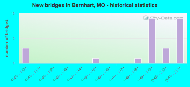
- New bridges - historical statistics
- 31900-1909
- 11950-1959
- 11980-1989
- 91990-1999
- 32000-2009
- 92010-2019

- Reconstructed bridges - Historical Statistics
- 11930-1939
- 01940-1949
- 01950-1959
- 01960-1969
- 01970-1979
- 01980-1989
- 11990-1999


- Bridge Condition - Deck
- 11.8%Very good
- 52.9%Good
- 29.4%Satisfactory
- 5.9%Fair

- Bridge Condition - Superstructure
- 5.9%Excellent
- 17.6%Very good
- 41.2%Good
- 29.4%Satisfactory
- 5.9%Fair

- Bridge Condition - Substructure
- 29.4%Very good
- 52.9%Good
- 17.6%Satisfactory

- Bridge Condition - Channel
- 4.5%Very good
- 31.8%Good
- 36.4%Satisfactory
- 27.3%Fair

- Bridge Condition - Culverts
- 40.0%Satisfactory
- 40.0%Fair
- 20.0%Poor
Find on map >> Show street view
Structure Number: 16198, Location: S 16 T 42 N R 5 E (Lat: 38.379347, Lng: -90.459264), Route carried "on" structure: County highway , Year Built: 1900, Status: Posted for load, Structure Length: 0.79m (2.59ft), Average Daily Traffic: 2,000 (year 2021), Truck Traffic: 5%, Average Future Daily Traffic: 3,400 (year 2041), Features Intersected: TRIB OF GLAIZE CR, Facility Carried by Structure: OLD LEMAY FERRY RD
Minimum Vertical Clearance: 30+ m (98+ ft), Kilometerpoint: 0.000, Lanes on structure: 2, Owner: County Highway Agency, Approaching Roadway Width: 7.9m (25.9ft), Material/Design: Steel, Design/Construction: Stringer/Multi-beam, Number Of Spans In Main Unit: 1, Length of Maximum Span: 7.0m (23.0ft), Curb-To-Curb Width: 7.4m (24.3ft), Out-to-Out Width: 8.0m (26.2ft)
Condition: Deck: Good, Superstructure: Satisfactory, Substructure: Satisfactory, Channel: Satisfactory, Operating Rating: 62.1 metric tons, Method Used To Determine Operating Rating: Allowable Stress (AS), Inventory Rating: 43.2 metric tons, Method Used To Determine Inventory Rating: Allowable Stress (AS), Structural Evaluation: Equal to present minimum criteria, Deck Geometry: Meets minimum limits, Waterway Adequacy: Better than present minimum criteria, Approach Roadway Alignment: Equal to present minimum criteria, Designated Inspection Frequency: Every 24 months, Inspection Date: Febuary 2021, Deck Structure Type: Concrete Cast-file-Place, Wearing Surface/Protective System: Wearing Surface: Bituminous
Find on map >> Show street view
Structure Number: 16683, Location: S 335 T 42 N R 5 E (Lat: 38.354572, Lng: -90.425064), Route carried "on" structure: County highway 106, Year Built: 1985, Year Reconstructed: 1998, Status: Posted for load, Structure Length: 3.26m (10.70ft), Average Daily Traffic: 1,173 (year 2021), Truck Traffic: 10%, Average Future Daily Traffic: 1,994 (year 2041), Design Load: HS 20, Features Intersected: TRIB OF GLAIZE CR, Facility Carried by Structure: MOSS HOLLOW RD
Minimum Vertical Clearance: 30+ m (98+ ft), Kilometerpoint: 0.483, Lanes on structure: 2, Owner: County Highway Agency, Approaching Roadway Width: 6.7m (22.0ft), Skew: 4 degrees, Material/Design: Prestressed concrete, Design/Construction: Tee Beam, Number Of Spans In Main Unit: 3, Length of Maximum Span: 10.4m (34.1ft), Curb-To-Curb Width: 8.6m (28.2ft), Out-to-Out Width: 9.4m (30.8ft)
Condition: Deck: Satisfactory, Superstructure: Satisfactory, Substructure: Good, Channel: Satisfactory, Operating Rating: 68.4 metric tons, Method Used To Determine Operating Rating: Load Factor (LF), Inventory Rating: 41.4 metric tons, Method Used To Determine Inventory Rating: Load Factor (LF), Structural Evaluation: Equal to present minimum criteria, Deck Geometry: Somewhat better than minimum adequacy, Waterway Adequacy: Superior to present desirable criteria, Approach Roadway Alignment: Equal to present desirable criteria, Designated Inspection Frequency: Every 24 months, Inspection Date: Febuary 2021, Deck Structure Type: Concrete Cast-file-Place
Find on map >> Show street view
Structure Number: 19288, Location: S 6 T 41 N R 6 E (Lat: 38.317822, Lng: -90.388839), Route carried "on" structure: County highway 191, Year Built: 1900, Status: Posted for load, Structure Length: 0.67m (2.20ft), Average Daily Traffic: 100 (year 2021), Truck Traffic: 10%, Average Future Daily Traffic: 170 (year 2041), Features Intersected: TRIB OF MISSISSIPP, Facility Carried by Structure: KOCH VALLEY RD
Minimum Vertical Clearance: 30+ m (98+ ft), Kilometerpoint: 0.644, Lanes on structure: 2, Owner: County Highway Agency, Approaching Roadway Width: 7.3m (24.0ft), Material/Design: Concrete continuous, Design/Construction: Culvert, Number Of Spans In Main Unit: 2, Length of Maximum Span: 3.0m (9.8ft), Curb-To-Curb Width: 6.0m (19.7ft), Out-to-Out Width: 6.6m (21.7ft)
Condition: Channel: Fair, Culverts: Fair, Operating Rating: 49.5 metric tons, Method Used To Determine Operating Rating: Allowable Stress (AS), Inventory Rating: 16.2 metric tons, Method Used To Determine Inventory Rating: Allowable Stress (AS), Structural Evaluation: Somewhat better than minimum adequacy, Deck Geometry: Meets minimum limits, Waterway Adequacy: Equal to present desirable criteria, Approach Roadway Alignment: Equal to present desirable criteria, Designated Inspection Frequency: Every 24 months, Inspection Date: Febuary 2021, Deck Structure Type: Concrete Cast-file-Place, Wearing Surface/Protective System: Wearing Surface: Bituminous
Find on map >> Show street view
Structure Number: 28379, Location: S 22 T 42 N R 5 E (Lat: 38.364442, Lng: -90.442128), Route carried "on" structure: County highway 101, Year Built: 1950, Status: Posted for load, Structure Length: 1.31m (4.30ft), Average Daily Traffic: 2,500 (year 2021), Truck Traffic: 10%, Average Future Daily Traffic: 4,250 (year 2041), Features Intersected: DRY FORK CR, Facility Carried by Structure: OLD RT M
Minimum Vertical Clearance: 30+ m (98+ ft), Kilometerpoint: 5.359, Lanes on structure: 2, Owner: County Highway Agency, Approaching Roadway Width: 7.3m (24.0ft), Material/Design: Concrete continuous, Design/Construction: Culvert, Number Of Spans In Main Unit: 3, Length of Maximum Span: 3.7m (12.1ft)
Condition: Channel: Fair, Culverts: Fair, Operating Rating: 49.5 metric tons, Method Used To Determine Operating Rating: Allowable Stress (AS), Inventory Rating: 17.1 metric tons, Method Used To Determine Inventory Rating: Allowable Stress (AS), Structural Evaluation: Meets minimum limits, Waterway Adequacy: Equal to present minimum criteria, Approach Roadway Alignment: Equal to present desirable criteria, Designated Inspection Frequency: Every 24 months, Inspection Date: Febuary 2021
Find on map >> Show street view
Structure Number: 30904, Location: S 335 T 42 N R 5 E (Lat: 38.357589, Lng: -90.423153), Route carried "on" structure: County highway 106, Year Built: 2004, Status: Posted for load, Structure Length: 1.31m (4.30ft), Average Daily Traffic: 1,173 (year 2021), Truck Traffic: 10%, Average Future Daily Traffic: 1,994 (year 2041), Design Load: HS 20, Features Intersected: GLAIZE CR, Facility Carried by Structure: MOSS HOLLOW RD
Minimum Vertical Clearance: 30+ m (98+ ft), Kilometerpoint: 0.080, Lanes on structure: 2, Owner: County Highway Agency, Approaching Roadway Width: 7.9m (25.9ft), Material/Design: Prestressed concrete, Design/Construction: Box Beam or Girders - Multiple, Number Of Spans In Main Unit: 1, Length of Maximum Span: 12.8m (42.0ft), Curb-To-Curb Width: 7.9m (25.9ft), Out-to-Out Width: 7.9m (25.9ft)
Condition: Deck: Very good, Superstructure: Very good, Substructure: Good, Channel: Satisfactory, Operating Rating: 54.0 metric tons, Method Used To Determine Operating Rating: Load Factor (LF), Inventory Rating: 32.4 metric tons, Method Used To Determine Inventory Rating: Load Factor (LF), Structural Evaluation: Better than present minimum criteria, Deck Geometry: Meets minimum limits, Waterway Adequacy: Superior to present desirable criteria, Approach Roadway Alignment: Equal to present minimum criteria, Designated Inspection Frequency: Every 24 months, Inspection Date: Febuary 2021, Deck Structure Type: Concrete Precast Panels, Wearing Surface/Protective System: Wearing Surface: Bituminous
Find on map >> Show street view
Structure Number: 31983, Location: S 28 T 42 N R 5 E (Lat: 38.350389, Lng: -90.477122), Route carried "on" structure: County highway 101, Year Built: 2008, Status: Posted for load, Structure Length: 1.19m (3.90ft), Average Daily Traffic: 866 (year 2021), Truck Traffic: 5%, Average Future Daily Traffic: 1,732 (year 2041), Design Load: HS 20, Features Intersected: TRIB OF GLAIZE CR, Facility Carried by Structure: WEDDE RD
Minimum Vertical Clearance: 30+ m (98+ ft), Kilometerpoint: 0.161, Lanes on structure: 2, Owner: County Highway Agency, Approaching Roadway Width: 11.0m (36.1ft), Skew: 1 degrees, Material/Design: Prestressed concrete, Design/Construction: Box Beam or Girders - Multiple, Number Of Spans In Main Unit: 1, Length of Maximum Span: 10.4m (34.1ft), Curb-To-Curb Width: 11.0m (36.1ft), Out-to-Out Width: 11.0m (36.1ft)
Condition: Deck: Good, Superstructure: Very good, Substructure: Good, Channel: Satisfactory, Operating Rating: 54.9 metric tons, Method Used To Determine Operating Rating: Load Factor (LF), Inventory Rating: 32.4 metric tons, Method Used To Determine Inventory Rating: Load Factor (LF), Structural Evaluation: Better than present minimum criteria, Deck Geometry: Better than present minimum criteria, Waterway Adequacy: Superior to present desirable criteria, Approach Roadway Alignment: Equal to present minimum criteria, Designated Inspection Frequency: Every 24 months, Inspection Date: Febuary 2021, Deck Structure Type: Concrete Cast-file-Place, Wearing Surface/Protective System: Deck Protection: Epoxy Coated Reinforcing
Find on map >> Show street view
Structure Number: 32902, Location: S 747 T 42 N R 6 E (Lat: 38.348292, Lng: -90.395600), Route carried "on" structure: Interstate 55, Year Built: 2010, Status: Open, Structure Length: 9.65m (31.66ft), Average Daily Traffic: 34,101 (year 2021), Truck Traffic: 17%, Average Future Daily Traffic: 63,087 (year 2041), Features Intersected: RT M, GLAIZE CR
Minimum Vertical Clearance: 30+ m (98+ ft), Kilometerpoint: 298.090, Lanes on structure: 4, Lanes under structure: 4, Base Highway Network: Yes, Owner: State Highway Agency, Approaching Roadway Width: 19.7m (64.6ft), Skew: 2 degrees, Material/Design: Steel continuous, Design/Construction: Stringer/Multi-beam, Number Of Spans In Main Unit: 3, Length of Maximum Span: 40.5m (132.9ft), Curb-To-Curb Width: 19.7m (64.6ft), Out-to-Out Width: 20.5m (67.3ft)
Condition: Deck: Good, Superstructure: Good, Substructure: Good, Channel: Good, Operating Rating: 48.6 metric tons, Method Used To Determine Operating Rating: Load Factor (LF), Inventory Rating: 28.8 metric tons, Method Used To Determine Inventory Rating: Load Factor (LF), Structural Evaluation: Better than present minimum criteria, Deck Geometry: Equal to present minimum criteria, Underclear: Meets minimum limits, Waterway Adequacy: Superior to present desirable criteria, Approach Roadway Alignment: Equal to present desirable criteria, Designated Inspection Frequency: Every 24 months, Inspection Date: November 2020, Deck Structure Type: Concrete Cast-file-Place, Wearing Surface/Protective System: Wearing Surface: Monolithic Concrete, Deck Protection: Epoxy Coated Reinforcing
Find on map >> Show street view
Structure Number: 32911, Location: S 25 T 42 N R 6 E (Lat: 38.348272, Lng: -90.395908), Route carried "on" structure: Interstate 55, Year Built: 2010, Status: Open, Structure Length: 9.61m (31.53ft), Average Daily Traffic: 42,534 (year 2021), Truck Traffic: 18%, Average Future Daily Traffic: 78,688 (year 2041), Features Intersected: RT M, GLAIZE CR
Minimum Vertical Clearance: 30+ m (98+ ft), Kilometerpoint: 39.513, Lanes on structure: 3, Lanes under structure: 4, Base Highway Network: Yes, Owner: State Highway Agency, Approaching Roadway Width: 17.9m (58.7ft), Skew: 2 degrees, Material/Design: Steel continuous, Design/Construction: Stringer/Multi-beam, Number Of Spans In Main Unit: 3, Length of Maximum Span: 40.5m (132.9ft), Curb-To-Curb Width: 17.9m (58.7ft), Out-to-Out Width: 18.7m (61.4ft)
Condition: Deck: Good, Superstructure: Good, Substructure: Very good, Channel: Good, Operating Rating: 69.3 metric tons, Method Used To Determine Operating Rating: Load Factor (LF), Inventory Rating: 41.4 metric tons, Method Used To Determine Inventory Rating: Load Factor (LF), Structural Evaluation: Better than present minimum criteria, Deck Geometry: Better than present minimum criteria, Underclear: Meets minimum limits, Waterway Adequacy: Superior to present desirable criteria, Approach Roadway Alignment: Equal to present desirable criteria, Designated Inspection Frequency: Every 24 months, Inspection Date: November 2020, Deck Structure Type: Concrete Cast-file-Place, Wearing Surface/Protective System: Wearing Surface: Monolithic Concrete, Deck Protection: Epoxy Coated Reinforcing
Find on map >> Show street view
Structure Number: 33118, Location: S 1696 T 42 N R 5 E (Lat: 38.362450, Lng: -90.465867), Route carried "on" structure: County highway , Year Built: 2011, Status: Posted for load, Structure Length: 1.95m (6.40ft), Average Daily Traffic: 2,700 (year 2021), Truck Traffic: 10%, Average Future Daily Traffic: 4,590 (year 2041), Design Load: HS 20, Features Intersected: GLAIZE CR, Facility Carried by Structure: OLD LEMAY FERRY RD
Minimum Vertical Clearance: 30+ m (98+ ft), Kilometerpoint: 12.558, Lanes on structure: 2, Owner: County Highway Agency, Approaching Roadway Width: 12.8m (42.0ft), Skew: 1 degrees, Material/Design: Prestressed concrete, Design/Construction: Box Beam or Girders - Multiple, Number Of Spans In Main Unit: 1, Length of Maximum Span: 18.7m (61.4ft), Curb-To-Curb Width: 12.2m (40.0ft), Out-to-Out Width: 13.4m (44.0ft)
Condition: Deck: Very good, Superstructure: Very good, Substructure: Good, Channel: Satisfactory, Operating Rating: 43.2 metric tons, Method Used To Determine Operating Rating: Load Factor (LF), Inventory Rating: 33.3 metric tons, Method Used To Determine Inventory Rating: Load Factor (LF), Structural Evaluation: Better than present minimum criteria, Deck Geometry: Equal to present minimum criteria, Waterway Adequacy: Superior to present desirable criteria, Approach Roadway Alignment: Equal to present desirable criteria, Designated Inspection Frequency: Every 24 months, Inspection Date: Febuary 2021, Wearing Surface/Protective System: Wearing Surface: Bituminous
Find on map >> Show street view
Structure Number: 33429, Location: S 34 T 42 N R 5 E (Lat: 38.330675, Lng: -90.448258), Route carried "on" structure: County highway , Year Built: 2011, Status: Posted for load, Structure Length: 2.04m (6.69ft), Average Daily Traffic: 390 (year 2021), Truck Traffic: 5%, Average Future Daily Traffic: 780 (year 2041), Features Intersected: TRIB OF GLAIZE CR, Facility Carried by Structure: WEDDE RD
Minimum Vertical Clearance: 30+ m (98+ ft), Kilometerpoint: 4.268, Lanes on structure: 2, Owner: County Highway Agency, Approaching Roadway Width: 11.0m (36.1ft), Material/Design: Prestressed concrete, Design/Construction: Box Beam or Girders - Multiple, Number Of Spans In Main Unit: 1, Length of Maximum Span: 19.4m (63.6ft), Curb-To-Curb Width: 11.0m (36.1ft), Out-to-Out Width: 11.0m (36.1ft)
Condition: Deck: Good, Superstructure: Excellent, Substructure: Very good, Channel: Good, Operating Rating: 59.4 metric tons, Method Used To Determine Operating Rating: Load Factor (LF), Inventory Rating: 35.1 metric tons, Method Used To Determine Inventory Rating: Load Factor (LF), Structural Evaluation: Equal to present desirable criteria, Deck Geometry: Equal to present desirable criteria, Waterway Adequacy: Superior to present desirable criteria, Approach Roadway Alignment: Equal to present minimum criteria, Designated Inspection Frequency: Every 24 months, Inspection Date: Febuary 2021, Deck Structure Type: Concrete Cast-file-Place, Wearing Surface/Protective System: Wearing Surface: Monolithic Concrete, Deck Protection: Epoxy Coated Reinforcing
Find on map >> Show street view
Structure Number: 33943, Location: S 25 T 42 N R 6 E (Lat: 38.348508, Lng: -90.394253), Route carried "on" structure: Ramp State highway , Year Built: 2012, Status: Open, Structure Length: 6.16m (20.21ft), Average Daily Traffic: 5,233 (year 2021), Truck Traffic: 10%, Average Future Daily Traffic: 9,681 (year 2041), Features Intersected: GLAIZE CR, Facility Carried by Structure: RP RTME TO IS55N N
Minimum Vertical Clearance: 30+ m (98+ ft), Kilometerpoint: 0.000, Lanes on structure: 3, Base Highway Network: Yes, Owner: State Highway Agency, Approaching Roadway Width: 18.3m (60.0ft), Material/Design: Concrete continuous, Design/Construction: Slab, Number Of Spans In Main Unit: 5, Length of Maximum Span: 12.8m (42.0ft), Curb-To-Curb Width: 18.3m (60.0ft), Out-to-Out Width: 19.1m (62.7ft)
Condition: Deck: Satisfactory, Superstructure: Satisfactory, Substructure: Good, Channel: Very good, Operating Rating: 84.6 metric tons, Method Used To Determine Operating Rating: Load Factor (LF), Inventory Rating: 50.4 metric tons, Method Used To Determine Inventory Rating: Load Factor (LF), Structural Evaluation: Equal to present minimum criteria, Deck Geometry: Superior to present desirable criteria, Waterway Adequacy: Superior to present desirable criteria, Approach Roadway Alignment: Equal to present desirable criteria, Designated Inspection Frequency: Every 24 months, Inspection Date: November 2020, Deck Structure Type: Concrete Cast-file-Place, Wearing Surface/Protective System: Wearing Surface: Monolithic Concrete, Deck Protection: Epoxy Coated Reinforcing
Find on map >> Show street view
Structure Number: 34794, Location: S 747 T 42 N R 6 E (Lat: 38.343467, Lng: -90.386756), Route carried "on" structure: US 61, Year Built: 2014, Status: Open, Structure Length: 4.97m (16.31ft), Average Daily Traffic: 5,985 (year 2021), Truck Traffic: 5%, Average Future Daily Traffic: 10,175 (year 2041), Features Intersected: GLAIZE CR
Minimum Vertical Clearance: 30+ m (98+ ft), Kilometerpoint: 304.625, Lanes on structure: 4, Owner: State Highway Agency, Approaching Roadway Width: 16.5m (54.1ft), Material/Design: Prestressed concrete continuous, Design/Construction: Stringer/Multi-beam, Number Of Spans In Main Unit: 3, Length of Maximum Span: 18.3m (60.0ft), Curb-To-Curb Width: 16.5m (54.1ft), Out-to-Out Width: 17.3m (56.8ft)
Condition: Deck: Good, Superstructure: Good, Substructure: Good, Channel: Good, Operating Rating: 56.7 metric tons, Method Used To Determine Operating Rating: Load Factor (LF), Inventory Rating: 31.5 metric tons, Method Used To Determine Inventory Rating: Load Factor (LF), Structural Evaluation: Better than present minimum criteria, Deck Geometry: Meets minimum limits, Waterway Adequacy: Superior to present desirable criteria, Approach Roadway Alignment: Equal to present desirable criteria, Designated Inspection Frequency: Every 24 months, Inspection Date: November 2020, Deck Structure Type: Concrete Cast-file-Place, Wearing Surface/Protective System: Wearing Surface: Latex Concrete, Deck Protection: Epoxy Coated Reinforcing
Find on map >> Show street view
Structure Number: 35266, Location: S 32 T 42 N R 5 E (Lat: 38.335278, Lng: -90.490000), Route carried "on" structure: County highway 197, Year Built: 2016, Status: Posted for load, Structure Length: 1.28m (4.20ft), Average Daily Traffic: 1,179 (year 2021), Truck Traffic: 2%, Average Future Daily Traffic: 2,358 (year 2041), Features Intersected: TRIB TO GLAIZE CR, Facility Carried by Structure: OLD LEMAY FERRY RD
Minimum Vertical Clearance: 30+ m (98+ ft), Kilometerpoint: 0.000, Lanes on structure: 2, Owner: County Highway Agency, Approaching Roadway Width: 7.3m (24.0ft), Skew: 2 degrees, Material/Design: Prestressed concrete, Design/Construction: Slab, Number Of Spans In Main Unit: 1, Length of Maximum Span: 11.6m (38.1ft), Curb-To-Curb Width: 12.0m (39.4ft), Out-to-Out Width: 12.2m (40.0ft)
Condition: Deck: Good, Superstructure: Good, Substructure: Very good, Channel: Satisfactory, Operating Rating: 54.9 metric tons, Method Used To Determine Operating Rating: Load and Resistance Factor (LRFR), Inventory Rating: 42.3 metric tons, Method Used To Determine Inventory Rating: Load and Resistance Factor (LRFR), Structural Evaluation: Better than present minimum criteria, Deck Geometry: Equal to present minimum criteria, Waterway Adequacy: Equal to present minimum criteria, Approach Roadway Alignment: Equal to present minimum criteria, Designated Inspection Frequency: Every 24 months, Inspection Date: January 2021, Deck Structure Type: Concrete Cast-file-Place, Wearing Surface/Protective System: Wearing Surface: Monolithic Concrete, Deck Protection: Epoxy Coated Reinforcing
Find on map >> Show street view
Structure Number: 35989, Location: S 24 T 42 N R 5 E (Lat: 38.355833, Lng: -90.413611), Route carried "on" structure: County highway 807, Year Built: 1996, Status: Open, Structure Length: 0.62m (2.03ft), Average Daily Traffic: 300 (year 2021), Truck Traffic: 1%, Average Future Daily Traffic: 510 (year 2041), Design Load: H 20, Features Intersected: TRIB OF GLAIZE CR, Facility Carried by Structure: CASTLEGATE DR
Minimum Vertical Clearance: 30+ m (98+ ft), Kilometerpoint: 0.000, Lanes on structure: 2, Owner: County Highway Agency, Approaching Roadway Width: 6.1m (20.0ft), Material/Design: Concrete, Design/Construction: Culvert, Number Of Spans In Main Unit: 2, Length of Maximum Span: 3.0m (9.8ft)
Condition: Channel: Fair, Culverts: Satisfactory, Operating Rating: 48.6 metric tons, Method Used To Determine Operating Rating: Load Factor (LF), Inventory Rating: 28.8 metric tons, Method Used To Determine Inventory Rating: Load Factor (LF), Structural Evaluation: Equal to present minimum criteria, Waterway Adequacy: Equal to present desirable criteria, Approach Roadway Alignment: Equal to present minimum criteria, Designated Inspection Frequency: Every 24 months, Inspection Date: January 2021
Find on map >> Show street view
Structure Number: 36114, Location: S 1969 T 42 N R 5 E (Lat: 38.375400, Lng: -90.451800), Route carried "on" structure: County highway 822, Year Built: 1995, Status: Open, Structure Length: 1.07m (3.51ft), Average Daily Traffic: 120 (year 2021), Truck Traffic: 1%, Average Future Daily Traffic: 204 (year 2041), Features Intersected: TRIB TO GLAIZE CR, Facility Carried by Structure: KNEFF FARM CROSSNG
Minimum Vertical Clearance: 30+ m (98+ ft), Kilometerpoint: 0.161, Lanes on structure: 2, Owner: County Highway Agency, Approaching Roadway Width: 7.3m (24.0ft), Skew: 2 degrees, Material/Design: Steel, Design/Construction: Culvert, Number Of Spans In Main Unit: 1, Length of Maximum Span: 7.6m (24.9ft), Curb-To-Curb Width: 10.7m (35.1ft), Out-to-Out Width: 10.7m (35.1ft)
Condition: Channel: Satisfactory, Culverts: Satisfactory, Operating Rating: 54.0 metric tons, Method Used To Determine Operating Rating: Load Factor (LF), Inventory Rating: 32.4 metric tons, Method Used To Determine Inventory Rating: Load Factor (LF), Structural Evaluation: Equal to present minimum criteria, Deck Geometry: Better than present minimum criteria, Waterway Adequacy: Superior to present desirable criteria, Approach Roadway Alignment: Better than present minimum criteria, Designated Inspection Frequency: Every 24 months, Inspection Date: January 2021
Find on map >> Show street view
Structure Number: 36115, Location: S 335 T 42 N R 5 E (Lat: 38.352000, Lng: -90.430500), Route carried "on" structure: County highway 823, Year Built: 2005, Status: Open, Structure Length: 2.33m (7.64ft), Average Daily Traffic: 270 (year 2021), Truck Traffic: 1%, Average Future Daily Traffic: 459 (year 2041), Features Intersected: TRIB TO GLAIZE CR, Facility Carried by Structure: FOUNTAIN DR
Minimum Vertical Clearance: 30+ m (98+ ft), Kilometerpoint: 0.161, Lanes on structure: 2, Owner: County Highway Agency, Approaching Roadway Width: 8.0m (26.2ft), Material/Design: Prestressed concrete, Design/Construction: Box Beam or Girders - Multiple, Number Of Spans In Main Unit: 1, Length of Maximum Span: 21.4m (70.2ft), Curb-To-Curb Width: 9.2m (30.2ft), Out-to-Out Width: 9.2m (30.2ft)
Condition: Deck: Fair, Superstructure: Fair, Substructure: Good, Channel: Good, Operating Rating: 45.0 metric tons, Method Used To Determine Operating Rating: Load Factor (LF), Inventory Rating: 25.2 metric tons, Method Used To Determine Inventory Rating: Load Factor (LF), Structural Evaluation: Somewhat better than minimum adequacy, Deck Geometry: Equal to present minimum criteria, Waterway Adequacy: Superior to present desirable criteria, Approach Roadway Alignment: Equal to present desirable criteria, Designated Inspection Frequency: Every 24 months, Inspection Date: January 2021, Deck Structure Type: Concrete Cast-file-Place, Wearing Surface/Protective System: Wearing Surface: Bituminous, Deck Protection: Epoxy Coated Reinforcing
Find on map >> Show street view
Structure Number: 4269, Location: S 355 T 42 N R 5 E (Lat: 38.353675, Lng: -90.427367), Route carried "on" structure: State highway M, Year Built: 1996, Status: Open, Structure Length: 4.33m (14.21ft), Average Daily Traffic: 5,230 (year 2021), Truck Traffic: 10%, Average Future Daily Traffic: 8,891 (year 2041), Design Load: HS 20+Mod, Features Intersected: MOSS HOLLOW CR
Minimum Vertical Clearance: 30+ m (98+ ft), Kilometerpoint: 8.092, Lanes on structure: 2, Base Highway Network: Yes, Owner: State Highway Agency, Approaching Roadway Width: 12.2m (40.0ft), Skew: 1 degrees, Material/Design: Prestressed concrete continuous, Design/Construction: Stringer/Multi-beam, Number Of Spans In Main Unit: 3, Length of Maximum Span: 18.1m (59.4ft), Curb or Sidewalk Widths: Left: 0.2m (0.7ft), Right: 0.2m (0.7ft), Curb-To-Curb Width: 11.8m (38.7ft), Out-to-Out Width: 12.6m (41.3ft)
Condition: Deck: Good, Superstructure: Good, Substructure: Very good, Channel: Fair, Operating Rating: 85.5 metric tons, Method Used To Determine Operating Rating: Load Factor (LF), Inventory Rating: 49.5 metric tons, Method Used To Determine Inventory Rating: Load Factor (LF), Structural Evaluation: Better than present minimum criteria, Deck Geometry: Better than present minimum criteria, Waterway Adequacy: Equal to present desirable criteria, Approach Roadway Alignment: Equal to present desirable criteria, Designated Inspection Frequency: Every 24 months, Inspection Date: November 2020, Deck Structure Type: Concrete Cast-file-Place, Wearing Surface/Protective System: Wearing Surface: Monolithic Concrete, Deck Protection: Epoxy Coated Reinforcing
Find on map >> Show street view
Structure Number: 427, Location: S 355 T 42 N R 5 E (Lat: 38.353858, Lng: -90.427194), Route carried "on" structure: State highway M, Year Built: 1996, Status: Open, Structure Length: 4.27m (14.01ft), Average Daily Traffic: 5,002 (year 2021), Truck Traffic: 20%, Average Future Daily Traffic: 8,503 (year 2041), Design Load: HS 20+Mod, Features Intersected: MOSS HOLLOW CR
Minimum Vertical Clearance: 30+ m (98+ ft), Kilometerpoint: 3.888, Lanes on structure: 2, Base Highway Network: Yes, Owner: State Highway Agency, Approaching Roadway Width: 12.2m (40.0ft), Skew: 1 degrees, Material/Design: Prestressed concrete continuous, Design/Construction: Stringer/Multi-beam, Number Of Spans In Main Unit: 3, Length of Maximum Span: 17.9m (58.7ft), Curb or Sidewalk Widths: Left: 0.2m (0.7ft), Right: 0.2m (0.7ft), Curb-To-Curb Width: 11.8m (38.7ft), Out-to-Out Width: 12.6m (41.3ft)
Condition: Deck: Good, Superstructure: Good, Substructure: Very good, Channel: Fair, Operating Rating: 88.2 metric tons, Method Used To Determine Operating Rating: Load Factor (LF), Inventory Rating: 53.1 metric tons, Method Used To Determine Inventory Rating: Load Factor (LF), Structural Evaluation: Better than present minimum criteria, Deck Geometry: Better than present minimum criteria, Waterway Adequacy: Equal to present desirable criteria, Approach Roadway Alignment: Equal to present desirable criteria, Designated Inspection Frequency: Every 24 months, Inspection Date: November 2020, Deck Structure Type: Concrete Cast-file-Place, Wearing Surface/Protective System: Wearing Surface: Monolithic Concrete, Deck Protection: Epoxy Coated Reinforcing
Find on map >> Show street view
Structure Number: 4271, Location: S 21 T 42 N R 5 E (Lat: 38.359714, Lng: -90.467769), Route carried "on" structure: State highway M, Year Built: 1996, Status: Open, Structure Length: 12.83m (42.09ft), Average Daily Traffic: 5,230 (year 2021), Truck Traffic: 10%, Average Future Daily Traffic: 8,891 (year 2041), Design Load: HS 20+Mod, Features Intersected: CRD OLD LEMAY FERRY RD,
Minimum Vertical Clearance: 30+ m (98+ ft), Kilometerpoint: 4.144, Lanes on structure: 2, Lanes under structure: 2, Base Highway Network: Yes, Owner: State Highway Agency, Approaching Roadway Width: 12.2m (40.0ft), Material/Design: Prestressed concrete continuous, Design/Construction: Tee Beam, Number Of Spans In Main Unit: 4, Length of Maximum Span: 34.7m (113.8ft), Curb or Sidewalk Widths: Left: 0.2m (0.7ft), Right: 0.2m (0.7ft), Curb-To-Curb Width: 11.8m (38.7ft), Out-to-Out Width: 12.6m (41.3ft)
Condition: Deck: Satisfactory, Superstructure: Good, Substructure: Good, Channel: Good, Operating Rating: 92.7 metric tons, Method Used To Determine Operating Rating: Load Factor (LF), Inventory Rating: 48.6 metric tons, Method Used To Determine Inventory Rating: Load Factor (LF), Structural Evaluation: Better than present minimum criteria, Deck Geometry: Better than present minimum criteria, Underclear: Equal to present desirable criteria, Waterway Adequacy: Equal to present desirable criteria, Approach Roadway Alignment: Equal to present desirable criteria, Designated Inspection Frequency: Every 24 months, Inspection Date: January 2022, Deck Structure Type: Concrete Cast-file-Place, Wearing Surface/Protective System: Wearing Surface: Monolithic Concrete, Deck Protection: Epoxy Coated Reinforcing
Find on map >> Show street view
Structure Number: 4272, Location: S 21 T 42 N R 5 E (Lat: 38.359919, Lng: -90.467614), Route carried "on" structure: State highway M, Year Built: 1996, Status: Open, Structure Length: 12.83m (42.09ft), Average Daily Traffic: 5,002 (year 2021), Truck Traffic: 20%, Average Future Daily Traffic: 8,503 (year 2041), Design Load: HS 20+Mod, Features Intersected: CRD OLD LEMAY FERRY RD,
Minimum Vertical Clearance: 30+ m (98+ ft), Kilometerpoint: 7.747, Lanes on structure: 2, Lanes under structure: 2, Base Highway Network: Yes, Owner: State Highway Agency, Approaching Roadway Width: 12.2m (40.0ft), Material/Design: Prestressed concrete continuous, Design/Construction: Tee Beam, Number Of Spans In Main Unit: 4, Length of Maximum Span: 34.7m (113.8ft), Curb or Sidewalk Widths: Left: 0.2m (0.7ft), Right: 0.2m (0.7ft), Curb-To-Curb Width: 11.8m (38.7ft), Out-to-Out Width: 12.6m (41.3ft)
Condition: Deck: Satisfactory, Superstructure: Satisfactory, Substructure: Satisfactory, Channel: Good, Operating Rating: 92.7 metric tons, Method Used To Determine Operating Rating: Load Factor (LF), Inventory Rating: 48.6 metric tons, Method Used To Determine Inventory Rating: Load Factor (LF), Structural Evaluation: Equal to present minimum criteria, Deck Geometry: Better than present minimum criteria, Underclear: Meets minimum limits, Waterway Adequacy: Equal to present desirable criteria, Approach Roadway Alignment: Equal to present desirable criteria, Designated Inspection Frequency: Every 24 months, Inspection Date: January 2022, Deck Structure Type: Concrete Cast-file-Place, Wearing Surface/Protective System: Wearing Surface: Monolithic Concrete, Deck Protection: Epoxy Coated Reinforcing
Find on map >> Show street view
Structure Number: 4353, Location: S 30 T 42 N R 6 E (Lat: 38.348028, Lng: -90.396525), Route carried "on" structure: ServiceState highway 55, Year Built: 1995, Status: Open, Structure Length: 5.33m (17.49ft), Average Daily Traffic: 12,328 (year 2021), Truck Traffic: 5%, Average Future Daily Traffic: 22,190 (year 2041), Design Load: HS 20, Features Intersected: GLAIZE CR
Minimum Vertical Clearance: 30+ m (98+ ft), Kilometerpoint: 0.024, Lanes on structure: 4, Owner: State Highway Agency, Approaching Roadway Width: 19.5m (64.0ft), Skew: 2 degrees, Material/Design: Concrete continuous, Design/Construction: Slab, Number Of Spans In Main Unit: 4, Length of Maximum Span: 13.5m (44.3ft), Curb or Sidewalk Widths: Left: 0.2m (0.7ft), Right: 0.2m (0.7ft), Curb-To-Curb Width: 19.1m (62.7ft), Out-to-Out Width: 20.0m (65.6ft)
Condition: Deck: Satisfactory, Superstructure: Satisfactory, Substructure: Satisfactory, Channel: Satisfactory, Operating Rating: 67.5 metric tons, Method Used To Determine Operating Rating: Allowable Stress (AS), Inventory Rating: 40.5 metric tons, Method Used To Determine Inventory Rating: Allowable Stress (AS), Structural Evaluation: Equal to present minimum criteria, Deck Geometry: Equal to present minimum criteria, Waterway Adequacy: Equal to present desirable criteria, Approach Roadway Alignment: Equal to present desirable criteria, Designated Inspection Frequency: Every 24 months, Inspection Date: November 2020, Deck Structure Type: Concrete Cast-file-Place, Wearing Surface/Protective System: Wearing Surface: Monolithic Concrete, Deck Protection: Epoxy Coated Reinforcing
Find on map >> Show street view
Structure Number: 4665, Location: S 6 T 41 N R 6 E (Lat: 38.321011, Lng: -90.398742), Route carried "on" structure: US 61, Year Built: 1900, Year Reconstructed: 1935, Status: Open, Structure Length: 0.66m (2.17ft), Average Daily Traffic: 5,978 (year 2021), Truck Traffic: 7%, Average Future Daily Traffic: 10,163 (year 2041), Design Load: H 15, Features Intersected: BR OF BRAUHN CR
Minimum Vertical Clearance: 30+ m (98+ ft), Kilometerpoint: 307.710, Lanes on structure: 4, Owner: State Highway Agency, Approaching Roadway Width: 12.8m (42.0ft), Skew: 4 degrees, Material/Design: Concrete, Design/Construction: Culvert, Number Of Spans In Main Unit: 1, Length of Maximum Span: 3.4m (11.2ft)
Condition: Channel: Fair, Culverts: Poor, Operating Rating: 49.5 metric tons, Method Used To Determine Operating Rating: Load Factor (LF), Inventory Rating: 29.7 metric tons, Method Used To Determine Inventory Rating: Load Factor (LF), Structural Evaluation: Meets minimum limits, Waterway Adequacy: Equal to present desirable criteria, Approach Roadway Alignment: Equal to present desirable criteria, Length Of Structure Improvement: 0.13m (0.43ft), Designated Inspection Frequency: Every 24 months, Inspection Date: December 2020, Bridge Improvement Cost: $250,000, Roadway Improvement Cost: $25,000, Total Project Cost: $375,000 ( Estimate for 2022)
Find on map >> Show street view
Structure Number: 32902, Location: S 747 T 42 N R 6 E (Lat: 38.348292, Lng: -90.395600), Route carried "under" structure: State highway M, Year Built: 2010, Structure Length: 0. m, Average Daily Traffic: 7,100 (year 2021), Truck Traffic: 13%, Features Intersected: RT M, Facility Carried by Structure: IS 55 N
Minimum Vertical Clearance: 4.75m (15.58ft), Kilometerpoint: 10.968, Lanes on structure: 4, Lanes under structure: 4, Material/Design: Steel continuous, Design/Construction: Stringer/Multi-beam, Length of Maximum Span: 40.5m (132.9ft)
Find on map >> Show street view
Structure Number: 32911, Location: S 25 T 42 N R 6 E (Lat: 38.348272, Lng: -90.395908), Route carried "under" structure: State highway M, Year Built: 2010, Structure Length: 0. m, Average Daily Traffic: 18,565 (year 2021), Truck Traffic: 5%, Features Intersected: RT M, Facility Carried by Structure: IS 55 S
Minimum Vertical Clearance: 4.89m (16.04ft), Kilometerpoint: 10.939, Lanes on structure: 3, Lanes under structure: 4, Material/Design: Steel continuous, Design/Construction: Stringer/Multi-beam, Length of Maximum Span: 40.5m (132.9ft)
Find on map >> Show street view
Structure Number: 4271, Location: S 21 T 42 N R 5 E (Lat: 38.359714, Lng: -90.467769), Route carried "under" structure: County highway , Year Built: 1996, Structure Length: 0. m, Average Daily Traffic: 1,751 (year 2021), Truck Traffic: 5%, Features Intersected: CRD OLD LEMAY FERRY RD, Facility Carried by Structure: RT M E
Minimum Vertical Clearance: 19.81m (64.99ft), Kilometerpoint: 10.406, Lanes on structure: 2, Lanes under structure: 2, Material/Design: Prestressed concrete continuous, Design/Construction: Tee Beam, Length of Maximum Span: 34.7m (113.8ft)
Find on map >> Show street view
Structure Number: 4272, Location: S 21 T 42 N R 5 E (Lat: 38.359919, Lng: -90.467614), Route carried "under" structure: County highway , Year Built: 1996, Structure Length: 0. m, Average Daily Traffic: 1,739 (year 2021), Truck Traffic: 5%, Features Intersected: CRD OLD LEMAY FERRY RD, Facility Carried by Structure: RT M W
Minimum Vertical Clearance: 19.81m (64.99ft), Kilometerpoint: 10.379, Lanes on structure: 2, Lanes under structure: 2, Material/Design: Prestressed concrete continuous, Design/Construction: Tee Beam, Length of Maximum Span: 34.7m (113.8ft)